
After Sunday’s jet-forced snowstorm and shot of Arctic air, the atmosphere takes a “break” this week. We begin with record cold temperatures, but a pleasant warming trend will carry us through the week. Outside of a few clouds, we’re not expecting any additional precipitation through the upcoming weekend.
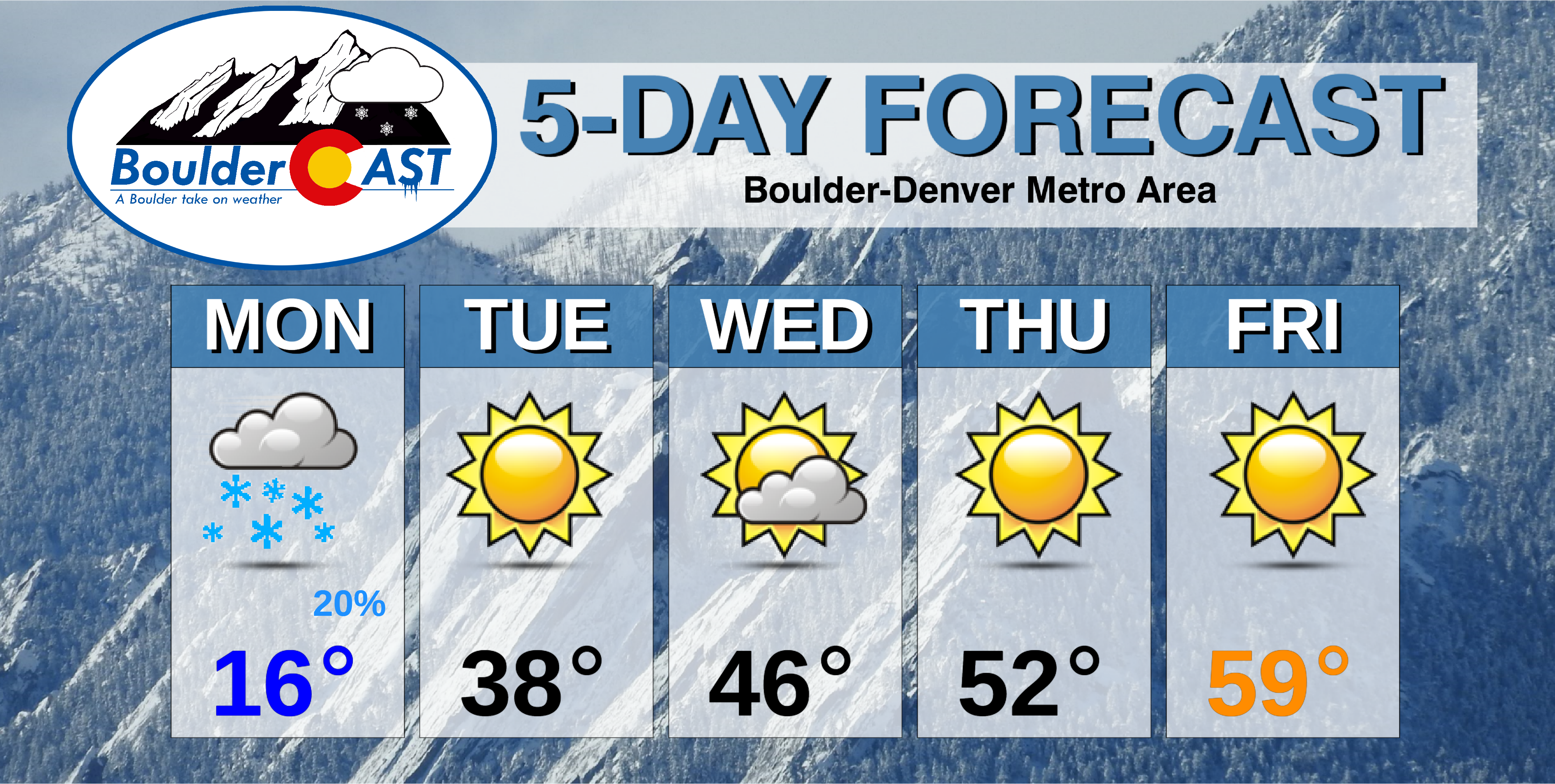
This week’s highlights include:
- Snow tapering off Monday morning with little to no additional accumulation
- Moisture from the snow has helped with the nearby wildfires
- Bitter, record-setting cold to start week trending to more seasonal weather towards week’s end
- After Monday, it will be a fairly sunny week with temperatures increasing each successive day through Saturday
DISCLAIMER: This weekly outlook forecast is created Monday morning and covers the entire upcoming week. Accuracy will decrease as the week progresses as this post is NOT updated. To receive daily updated forecasts from our team, subscribe to BoulderCAST Premium.

Cloudy and bitter cold to start
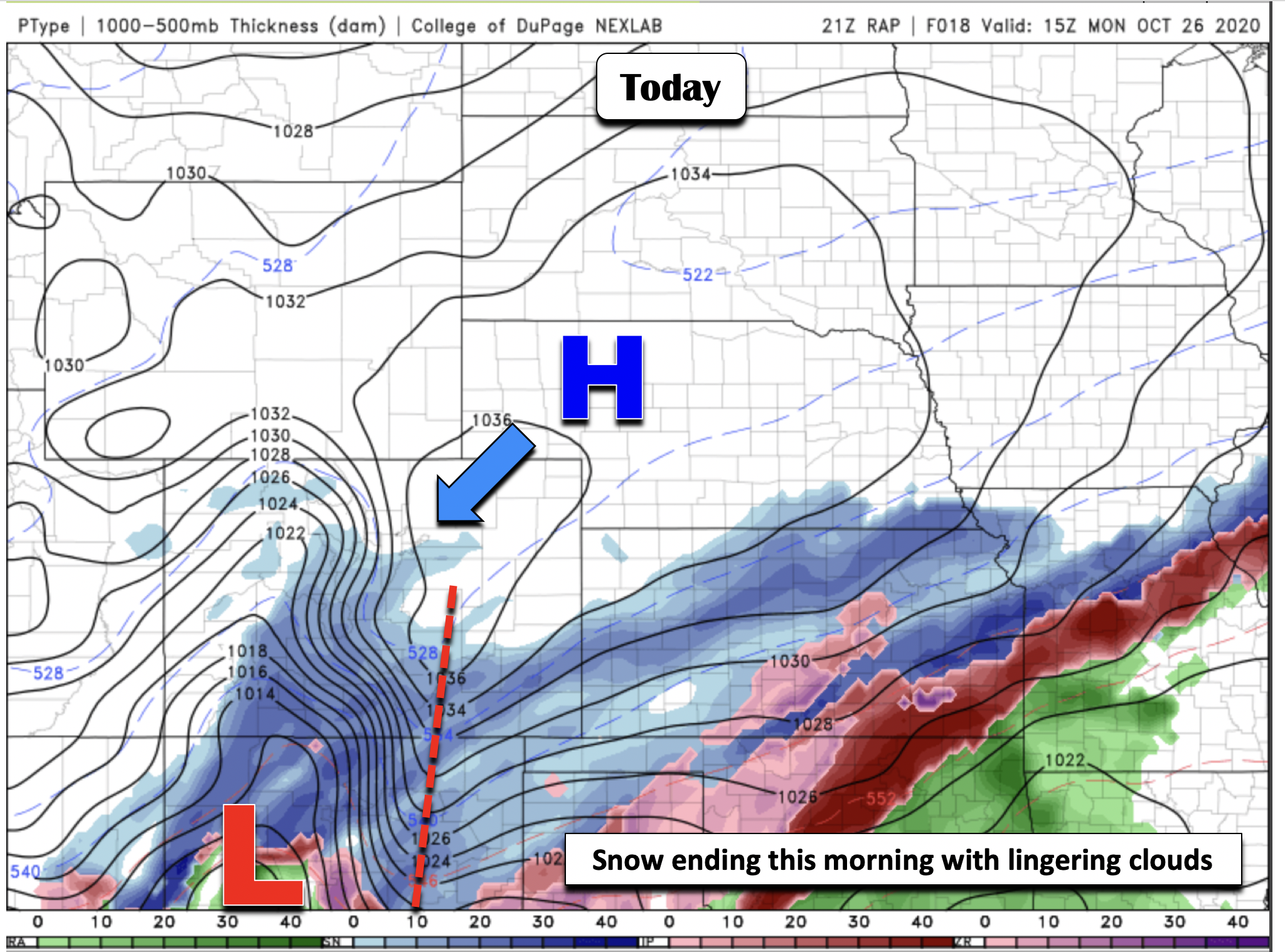
The week starts off, as you might have guessed, quite frigid. Our average high for today is in the lower 60’s. However, we will only reach the middle teens on this very cold Monday across the Front Range. This will lead to a record low maximum temperature for the date in just about every city. The previous record was 32°F in Boulder set in 2009. Light snow will taper off later through the morning from north to south and give way to just overcast skies. Little to no additional accumulation is expected at this point…really just flurries or very light snow showers. The snow will continue to move southward as the area of low pressure pushes into New Mexico. Little snow melt is expected on Monday as a result of the cold air and clouds in-place.
Boulder SMASHED the record low temperature this morning for Oct 26 by at least 12°F….(was 19°F, 2009). Current temps:
BoulderCAST Station – 7°F
Boulder Airport – 7°F
CU – 8°F
NCAR-Foothills – 7°F
NCAR-Mesa – 3°FThis will also go down as earliest single digit temp#COwx pic.twitter.com/RC47ivKCaz
— BoulderCAST Weather (@BoulderCAST) October 26, 2020
Tonight, clearing skies with the fresh snow cover will likely lead to record overnight low temperatures across the region. The record low Tuesday morning is 14°F for Boulder which is certainly going to be broken. We should have no problem dipping into the single digits by Tuesday morning. This will be the third consecutive record low temperatures set as a result of the weekend snowstorm.
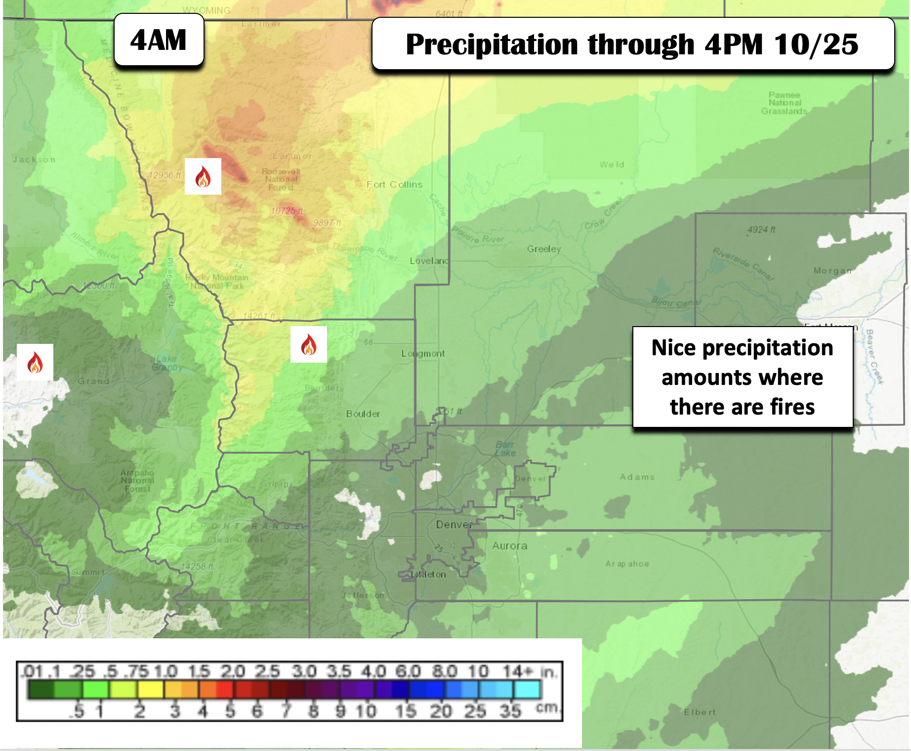
We will be posting a complete storm summary from this past weekend’s snow event later today, but here’s a quicklook. As of yesterday afternoon, welcomed precipitation amounts were observed over the Mountains and Plains (below). The highest totals fortunately also fell over the locations of the active fires (below). While the snow will not “extinguish” the fires, it will help firefighters battle the blazes. The snow could not have come at a better time.
A look at this week’s weather: hint – warmer and drier
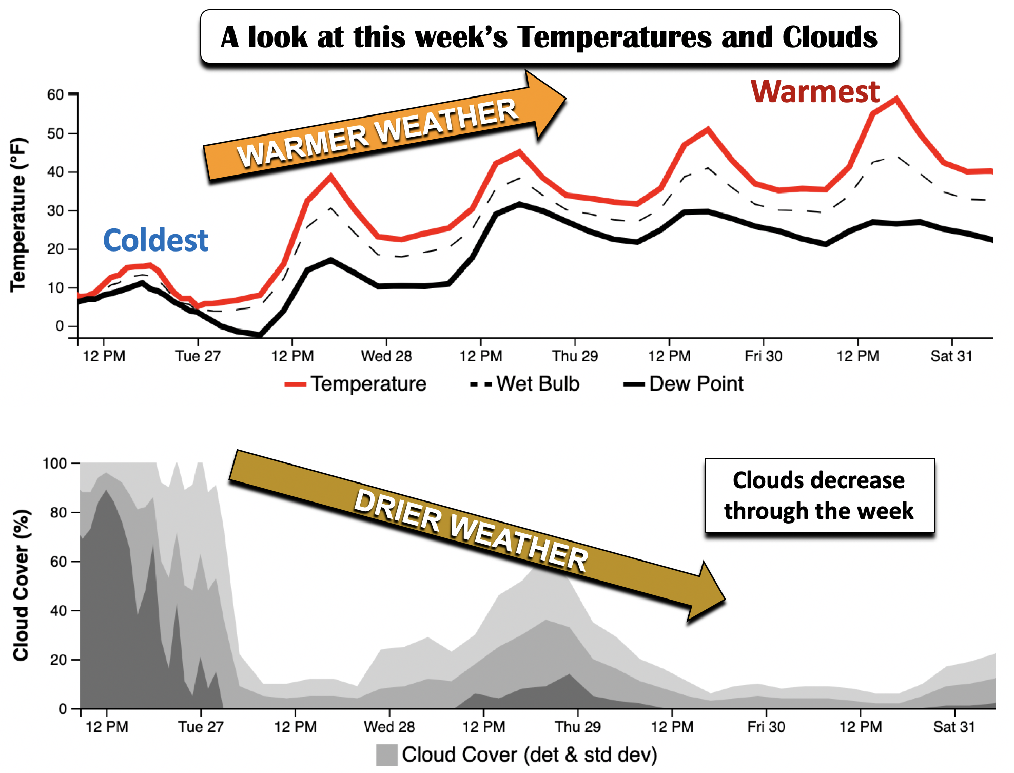
After today’s bitter cold, a much nicer trend is in store for the remainder of the week. Let’s take a bird’s eye view of the upcoming temperature and cloud forecast. This is shown below for temperature (red) and dewpoint (black) on the top panel and cloud cover percentage (%) in the bottom panel. As you can see, today will be our coldest day. Notice the upward trend in forecast high temperatures all the way through Friday. In addition, note the opposite trend in cloud cover, an overall sunny outlook after today. Outside of some clouds midweek, we will largely be basking in the sun. That will likely help to melt the snow by the end of the week/upcoming weekend, even in Boulder where nearly a foot of snow fell on Sunday.
Tuesday, the storm system continues to move south of Colorado, leaving weak high pressure over the state. That should allow for a pleasant warm-up from Sunday and Monday, with highs into the mid and upper 30’s. And with sunshine, you’ll be able to shovel that snow and clear your car off, if you didn’t get a chance to do it on Monday while the deep freeze was on-going.
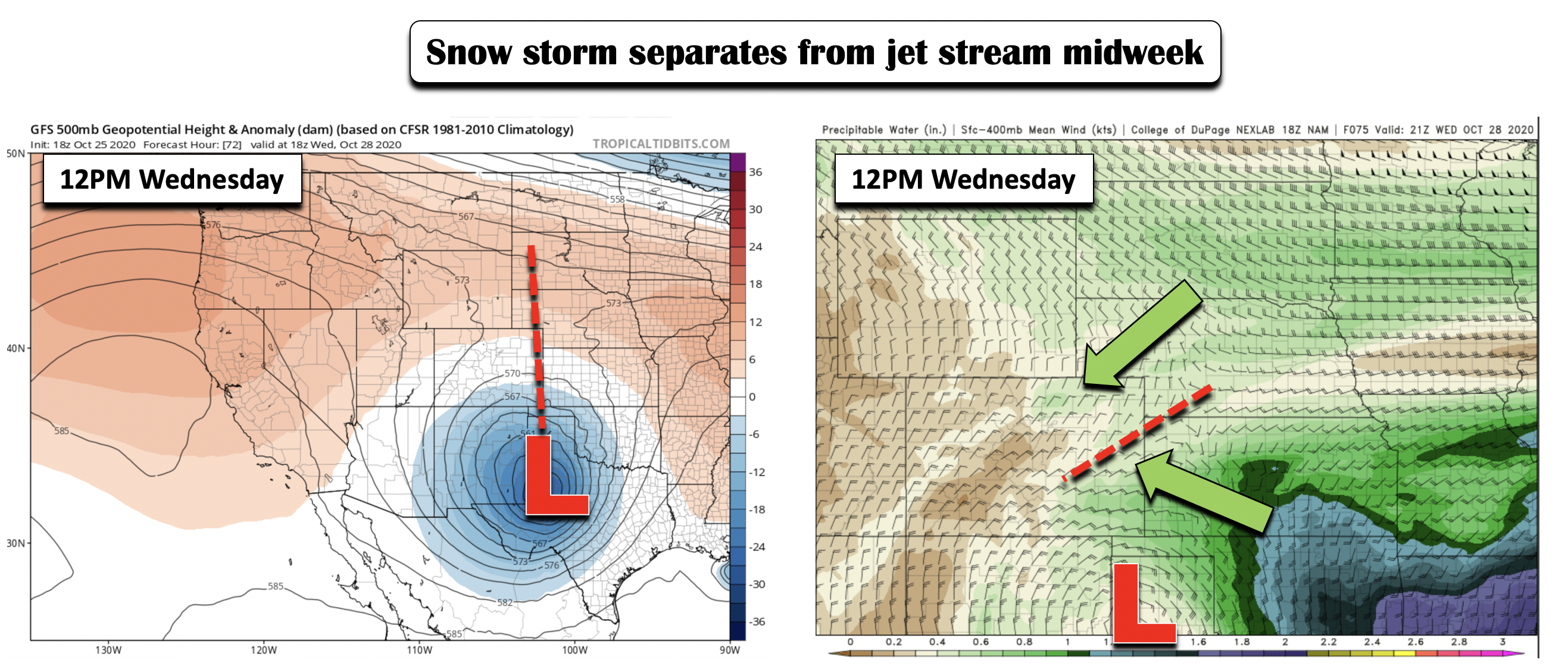
Come Wednesday, the aforementioned low pressure system is poised to be near the Texas panhandle (below left). While this is too far south of us to lead to any precipitation, the large area of rotation north of the system will continue to bring in moisture, both from the east and the northeast (below right). At this stage, we don’t expect any precipitation. However, do look for an uptick in afternoon clouds Wednesday with temperatures rising into the mid to upper 40’s.
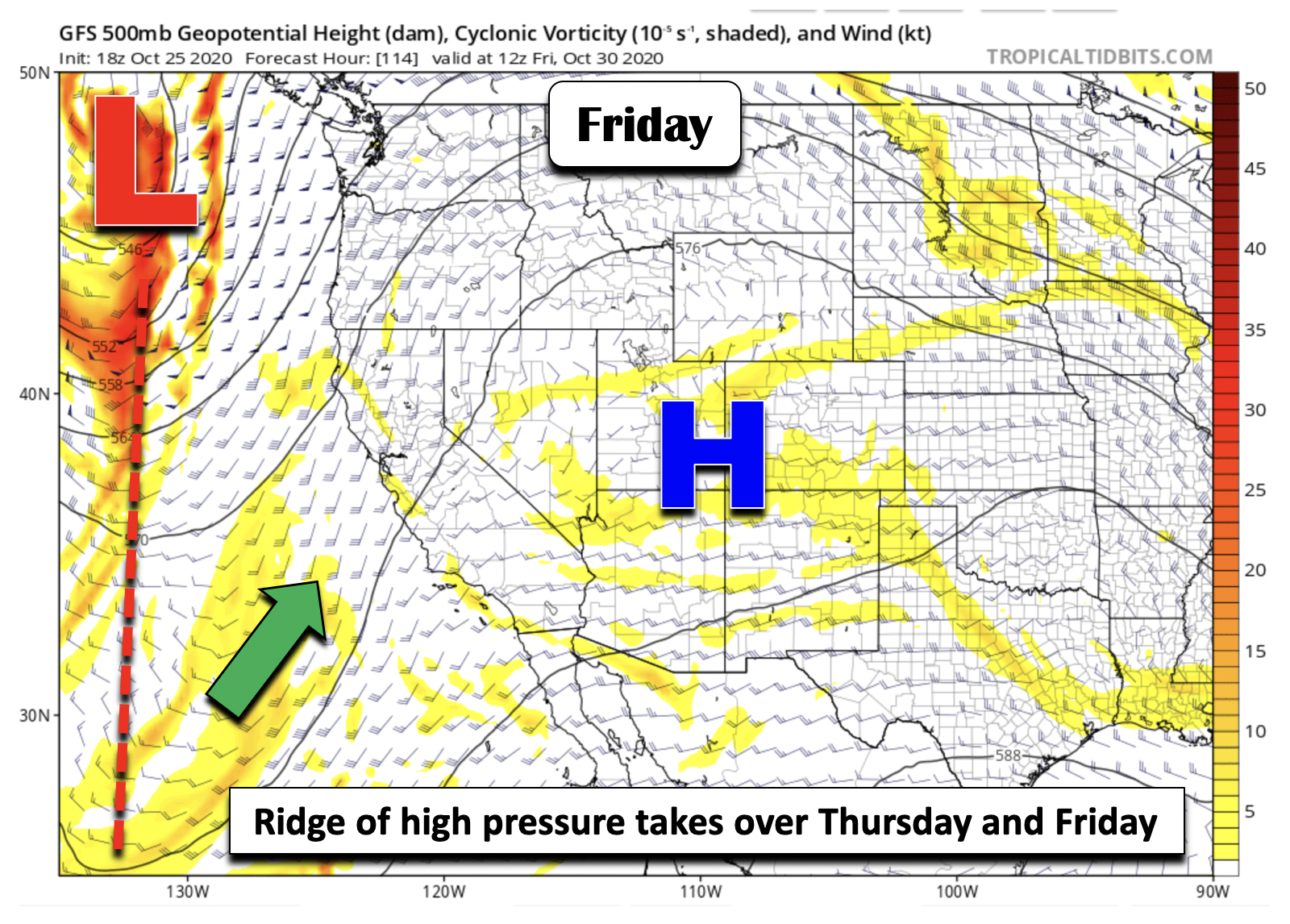
By Thursday, a ridge of high pressure will slowly take over, and by week’s end, the ridge will be largely in dominance (below). As you might expect with this pattern, this will facilitate lots of sunshine and high temperatures finally rebounding back to where we should be this time of year with highs Thursday in the lower 50’s and upper 50’s on Friday. Depending on how much snow is left come Friday, it is possible we could see lower 60’s to end the week, which is right where we should be this time of year – which would be lovely!
As for the upcoming weekend, it looks overall quiet at this point. A weak trough axis is predicted to make its way into Colorado late Saturday and Sunday as the westerly flow redevelops at the mid-levels of the atmosphere. However, this current pattern does not favor much in the way of precipitation. At the most, it will lead to increasing clouds – but with temperatures staying near seasonal normals.

That’s all for now. Look for our winter storm recap post later today. You may be surprised to see how much snow did or didn’t fall in other locations around the Front Range!
Have a good week!
Forecast Specifics:
Monday: Light snow ending in the morning from north to south with overcast skies lingering. Bitter cold with high temperatures in the middle teens on the Plains and lower teens in the Foothills.
Tuesday: Sunny and warmer but still well below average. Highs in the mid to upper 30’s for the Plains and upper 20’s in the Foothills.
Wednesday: Sunshine giving way to afternoon clouds. Highs in the mid to upper 40’s for the Plains and middle 30’s in the Foothills.
Thursday: Mostly sunny and warmer with highs in the lower 50’s on the Plains and lower 40’s for the Foothills.
Friday: Sunny and near normal with temperatures in the upper 50’s for the Plains and middle 40’s in the Foothills.
High Country: Clouds and snow on Monday give way to quiet conditions through the remainder of the week. The next chance of any possible precipitation will not be until the weekend, if at all. Check our PowderCAST page for daily updated forecasts for all the Colorado ski resorts. Here’s a look at the ski resort forecasts for Friday:
Help support our team of Front Range weather bloggers by joining BoulderCAST Premium. We talk Boulder and Denver weather every single day. Sign up now to get access to our daily forecast discussions each morning, complete six-day skiing and hiking forecasts powered by machine learning, first-class access to all our Colorado-centric high-resolution weather graphics, bonus storm updates and much more! Or not, we just appreciate your readership!
.
Spread the word, share the BoulderCAST forecast!
.


You must be logged in to post a comment.