Despite the progressive cold front on Sunday which brought strong winds, dangerous fire conditions, Mountain snow, and even a dust storm to some portions of the eastern Plains, we will see a nice rebound in our temperatures immediately to start the week. However, a stronger cold front will arrive later in the week leading to chilly temperatures . It is looking like another dry week as well, with any precipitation chances holding off until sometime next week.
This week’s highlights include:
- The polar jet stream will shift northward over the next few days to allow above average temperatures
- The same jet shifts back southward after Wednesday for a notably colder end to the week
- Mostly sunny through much of the week with no chance of precipitation
- Breezy conditions are expected Monday and Wednesday with high fire danger as a result
DISCLAIMER: This weekly outlook forecast is created Monday morning and covers the entire upcoming week. Accuracy will decrease as the week progresses as this post is NOT updated. To receive daily updated forecasts from our team, subscribe to BoulderCAST Premium.

Above average to start
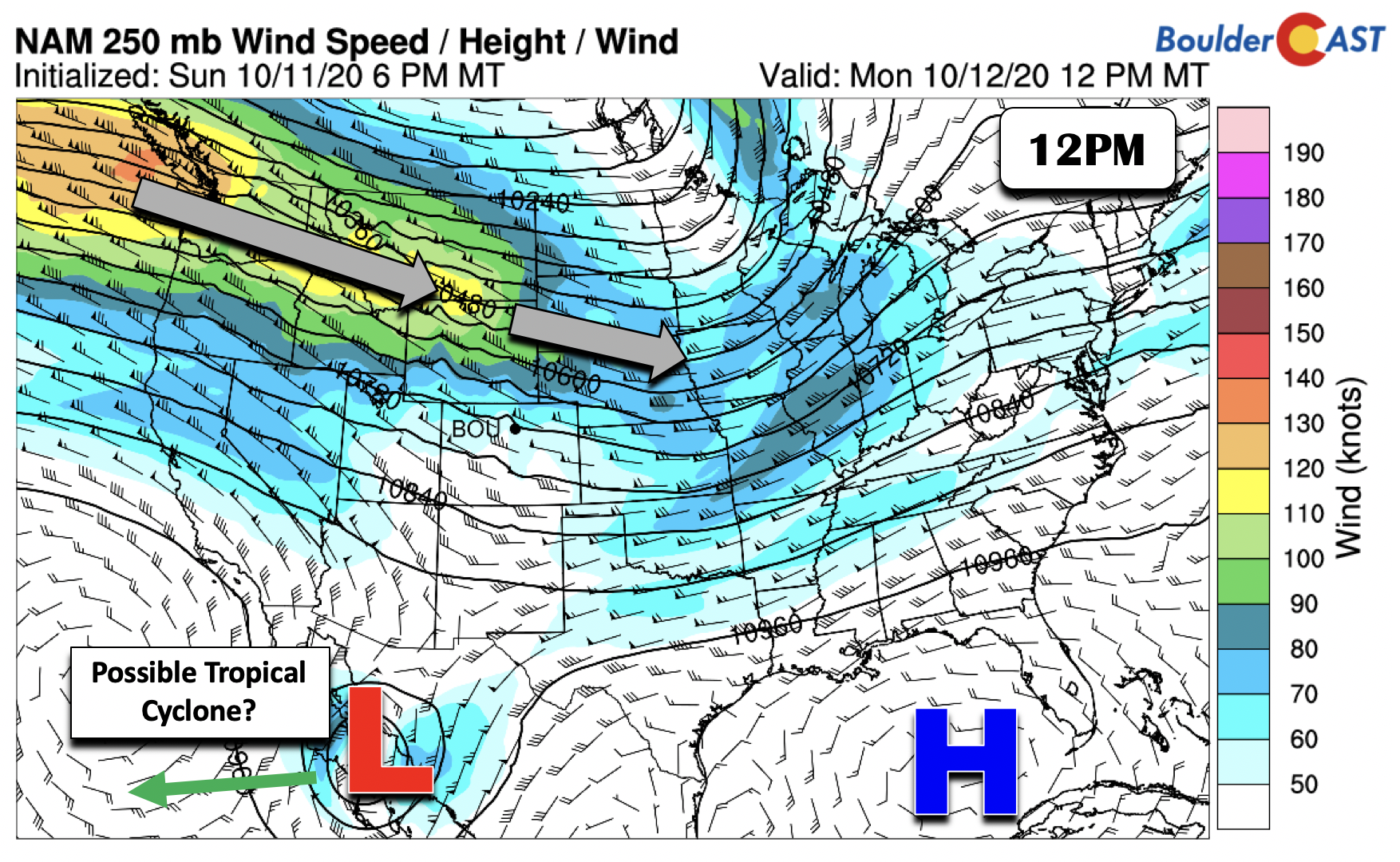
After a breezy and chilly end to our weekend, the work week is going to start out much nicer with above average temperatures on the horizon. Below shows the nation’s weather at roughly 30,000 feet up. A strong jet stream extends from the Pacific Northwest into the Midwest today. This jet stream will be the major player for our weather this week as it meanders north and south through the period. Although not expected to impact us, there are some hints in the forecast models that a weak area of low pressure near Baja California could become a tropical cyclone as it moves west-southwest out over the Pacific Ocean in the next few days.
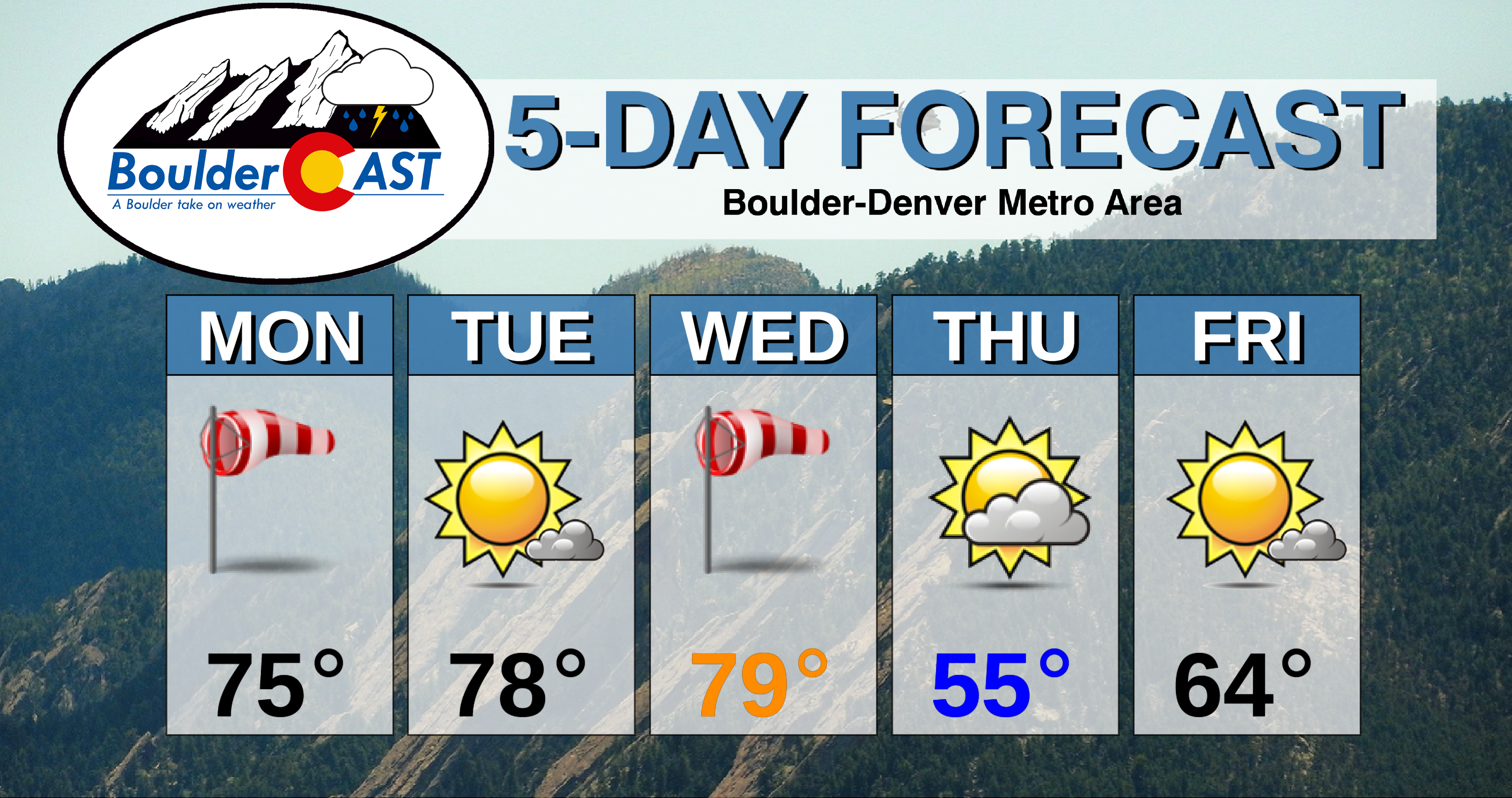
Highs on Monday will top out near the middle 70’s. That’s right…temperatures will still be several degrees above normal the day after a relatively strong cold front. This is the kind of October it has been so far…
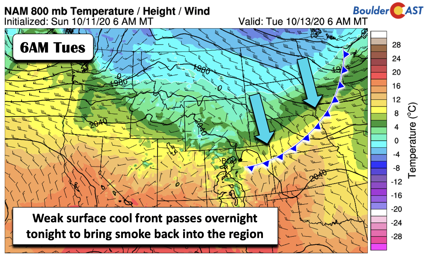
It will be another breezy day, with westerly winds gusting up to 30 mph at times. Though, expect winds to taper off a tad as the afternoon wears on. Red Flag Warnings remain active through this evening due to those gusty winds. After the surge of dust and smoke accompanying the cold front on Sunday, air quality has improved drastically in the Front Range. However, northeasterly winds developing overnight tonight with a weak cool front sliding south (below) will likely lower air quality early Tuesday morning as some smoke returns.
As much as we’d like to predict a total conclusion to the smoke for the year, that isn’t going to happen until the massive nearby fires are closer to being extinguished.
6 out of the 10 largest wildfires in Colorado state history we're caused by humans. Take that Mother Nature!#COwx #Wildfires #MullenFire #CameronPeakFire #Smoke pic.twitter.com/sVGobCTJi4
— BoulderCAST Weather (@BoulderCAST) October 9, 2020
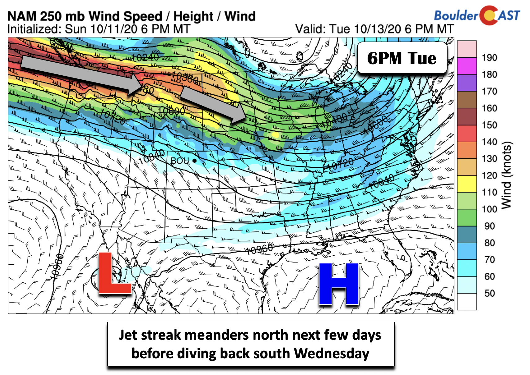
The front tonight will do little to impact high temperatures tomorrow. After the northerly winds in the morning on Tuesday, southerly flow will return with temperatures rebounding some 10 degrees above average into the upper 70’s. The jet stream tomorrow will migrate northward into Montana (below), allowing for the nice warm-up!
Below average for latter half of the work week
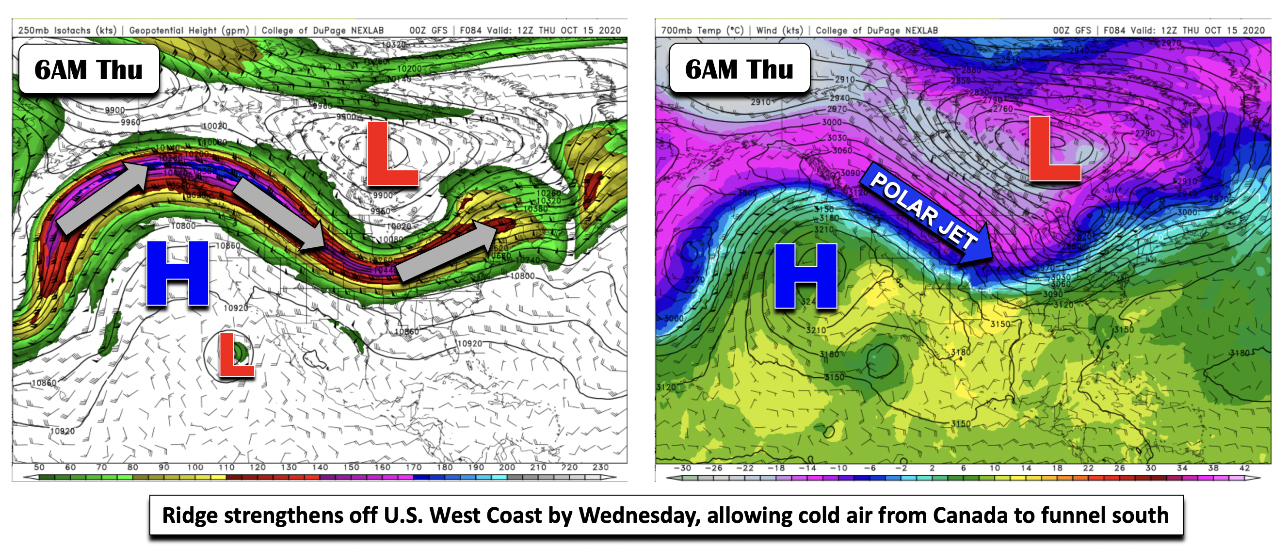
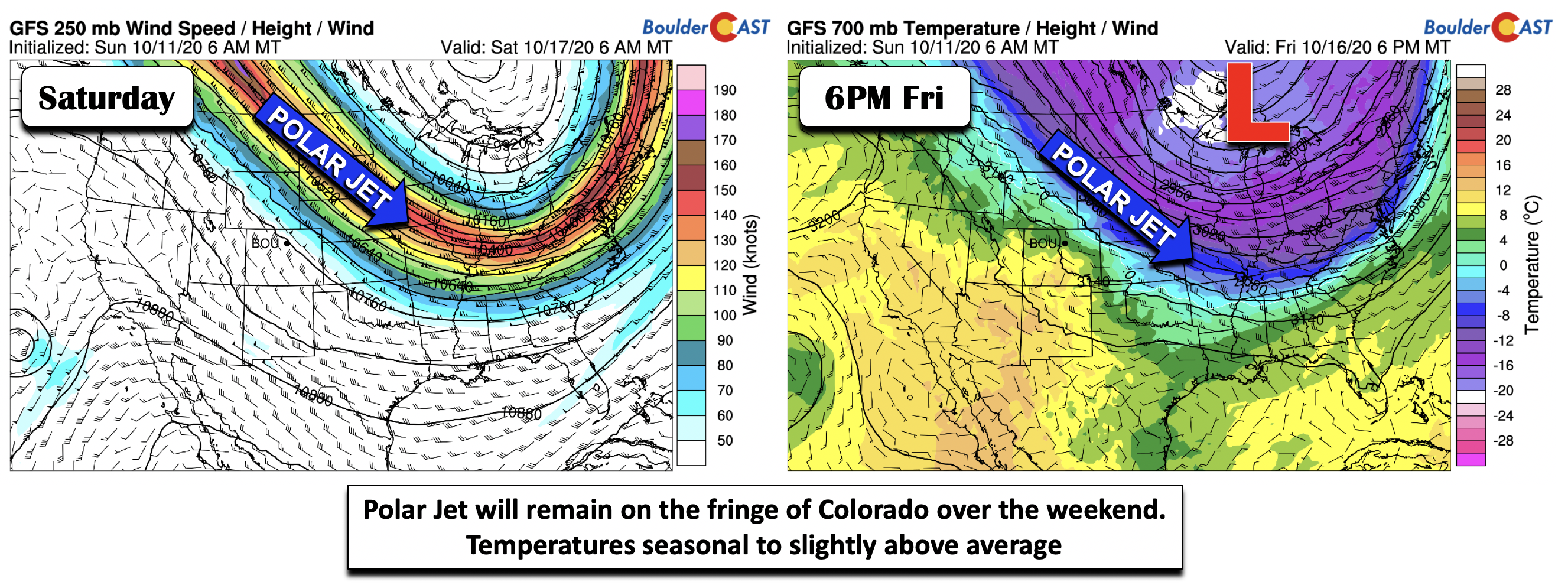
As we go from Wednesday into Friday, the pattern takes on a more active and colder trend. To see how this forms, let’s look at forecast maps for the entire North American region of the upper-level jet (below left) and the temperatures at 700mb (below right). The start of the week will see a zonal (west to east) flow of the jet stream over the northwest U.S. However, as high pressure offshore builds northward into the Pacific Northwest, the jet stream will meander back southward out of Canada and open the flood gates for some very cold air to penetrate into the United States, from Colorado into the Midwest and the Northeast.
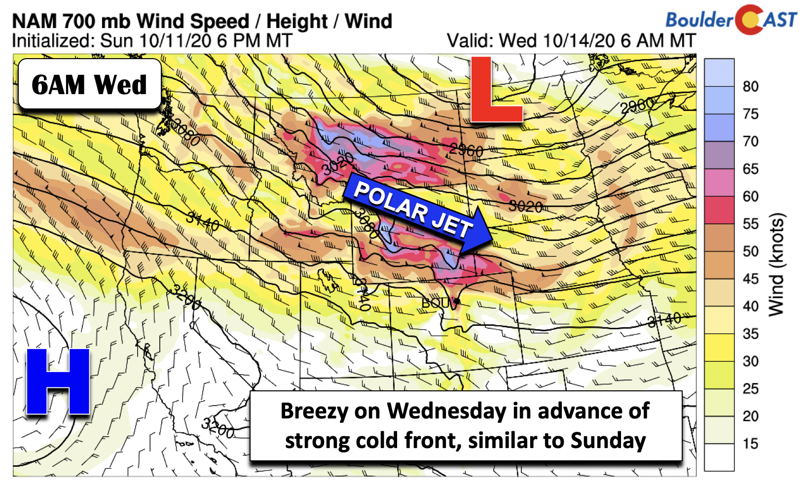
Temperatures ahead of the front on Wednesday may briefly reach the low 80’s before turning colder with highs in the 50’s Thursday and 60’s on Friday. Similar to our Sunday, the passage of the front will be accompanied by gusty west-northwest winds (below) and as a result, high fire danger. Winds could easily gust over 35 mph again on Wednesday afternoon/evening. The current guidance places the front through the Front Range in the afternoon, but this will likely shift a little as we get closer.
In the extended, the polar jet stream which brings the colder air down from Canada, is expected to ooze further south and east into the eastern U.S. by the weekend, allowing for a slight moderation in our temperatures Friday and Saturday. That could lead to more seasonal or even slightly above average temperatures by the weekend. However, confidence in this scenario is not overly high as the polar jet is likely to be on the fringe of the Colorado/Kansas border, keeping cold fronts nearby for chilly weather. Our forecast tentatively calls for a slow moderation in temperatures heading into the upcoming weekend.
You’ll probably notice that we didn’t mention any precipitation in this week’s forecast discussion. Well, that’s because there isn’t any, unfortunately. Dry weather will persist across the area through the upcoming weekend with a pattern quite unfavorable for any moisture in the Rocky Mountain State.
That’s all for now. Have a super week!
Forecast Specifics:
Monday: Mostly sunny with a few wave clouds, breezy, and mild with highs in the middle 70’s on the Plains and lower 60’s in the Foothills. West winds gusting to 30 mph at times.
Tuesday: Morning haze and smoke possible, followed by mostly sunny skies and highs in the upper 70’s for the Plains and middle 60’s in the Foothills.
Wednesday: Breezy and warm to start with highs near 80 on the Plains and upper 60’s in the Foothills, followed by falling temperatures from afternoon into evening with a dry cold frontal passage.
Thursday: Partly cloudy skies and chilly. Highs in the middle 50’s in the Denver Metro and middle 40’s in the Foothills.
Friday: A mix of clouds and sun and still chilly with highs in the lower to middle 60’s on the Plains and lower 50’s in the Foothills.
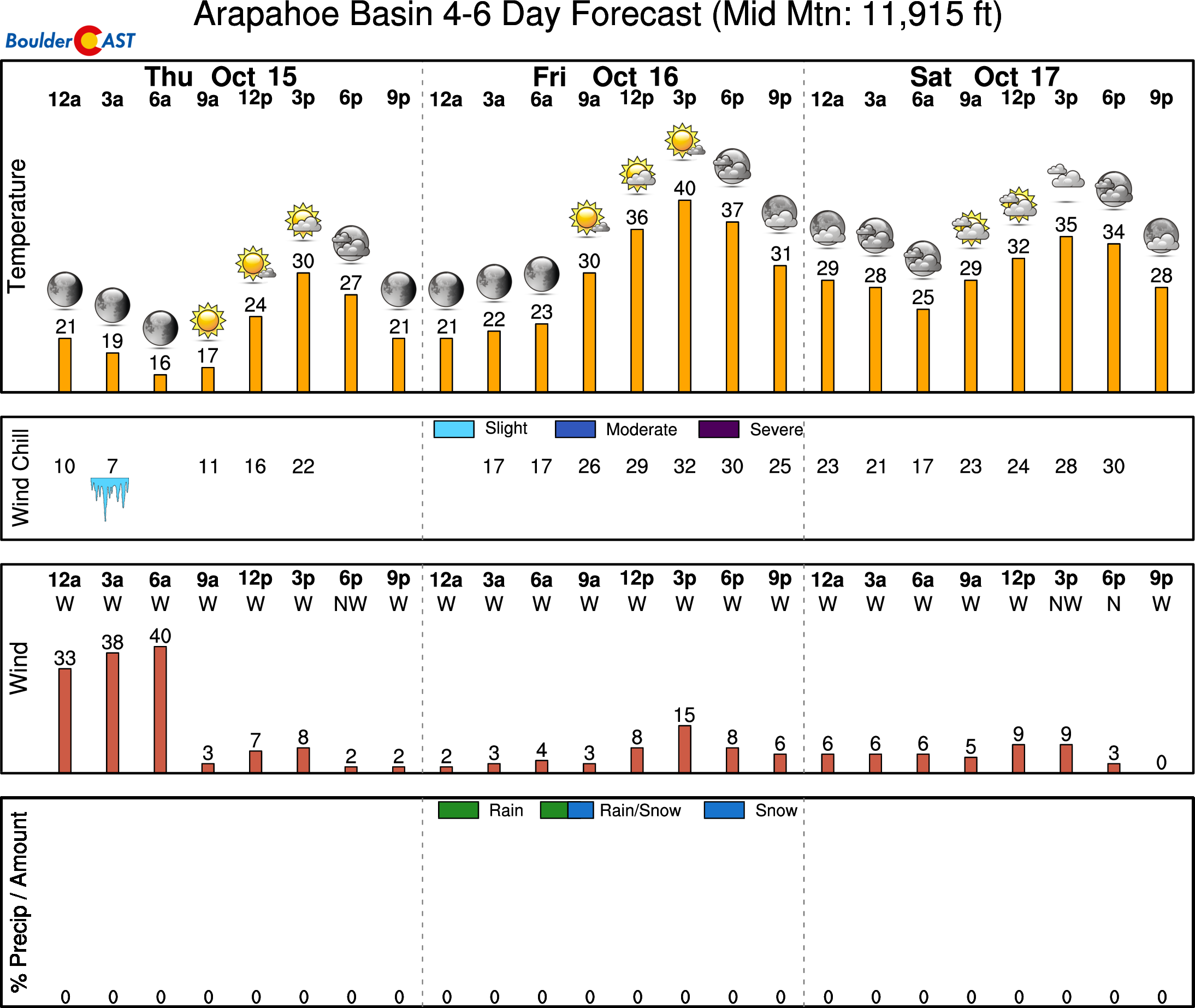
High Country: Gusty winds will prevail today through Wednesday across the higher terrain. Dry weather is expected much of the week, though we can’t rule out some snow showers over the northwest part of the state Wednesday and Thursday with the passage of a cold front. The rest of the week is dry and colder. Check our PowderCAST page for daily updated forecasts for all the Colorado ski resorts. Here’s a look at the extended outlook for A-Basin later this week:
Help support our team of Front Range weather bloggers by joining BoulderCAST Premium. We talk Boulder and Denver weather every single day. Sign up now to get access to our daily forecast discussions each morning, complete six-day skiing and hiking forecasts powered by machine learning, first-class access to all our Colorado-centric high-resolution weather graphics, bonus storm updates and much more! Or not, we just appreciate your readership!
.
Spread the word, share the BoulderCAST forecast!
.


You must be logged in to post a comment.