
The week starts out on the cold side with light accumulating snow Monday into Monday night. We discuss the timing, amounts, and provide our snowfall forecast map. Beyond Monday, a series of troughs will remain across the western United States keeping below seasonal temperatures over much of Colorado, but providing little to no additional precipitation.
This week’s highlights include:
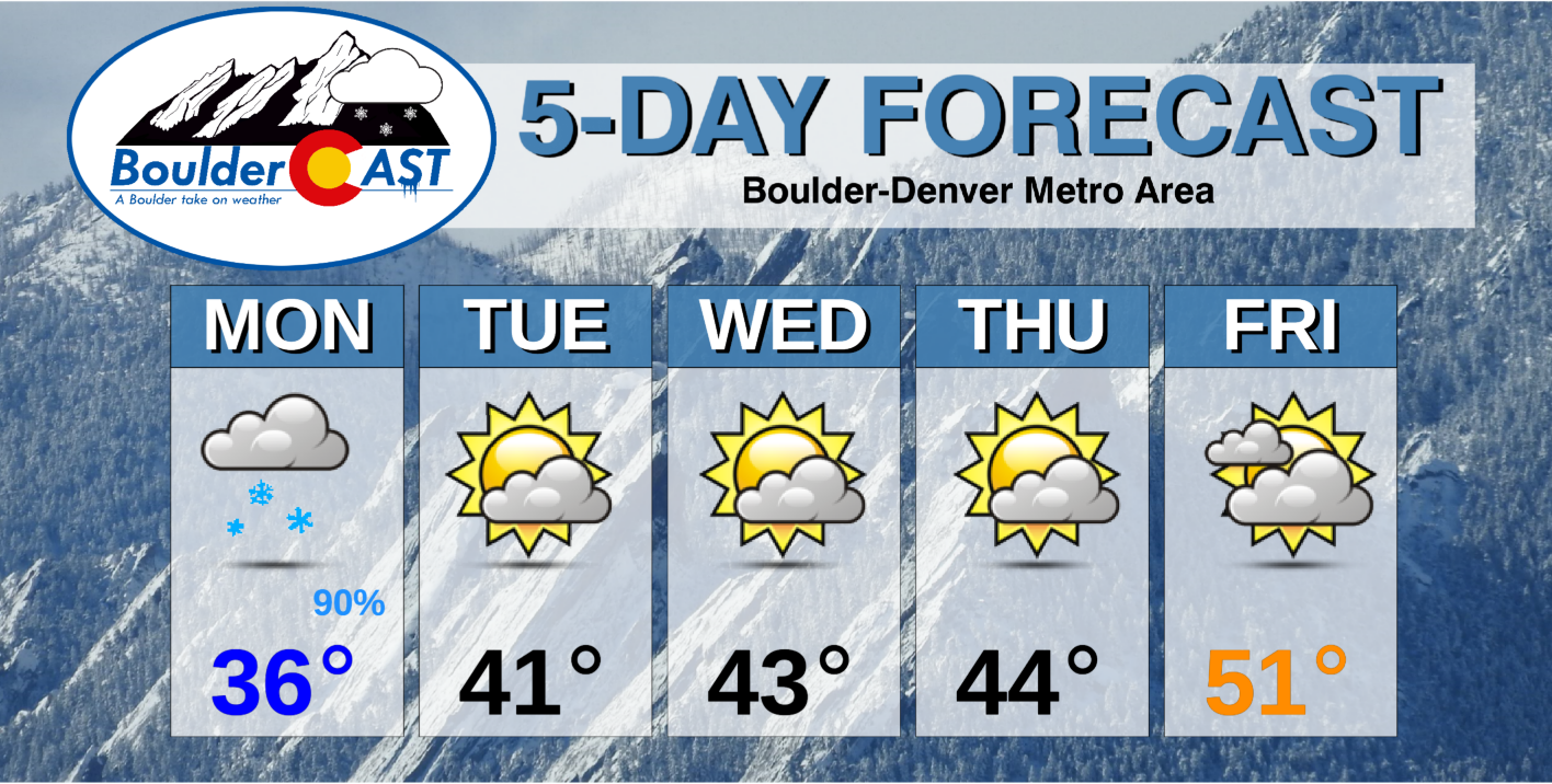
- A taste of winter on Monday with light snow and chilly temperatures, generally 2″ or less of accumulation
- Dry for the remainder of the week with temperatures below average in the 40’s
- A warmup by week’s end back into the 50’s!
DISCLAIMER: This weekly outlook forecast is created Monday morning and covers the entire upcoming week. Accuracy will decrease as the week progresses as this post is NOT updated. To receive daily updated forecasts from our team, subscribe to BoulderCAST Premium.

A cold and snowy start
Winter weather returns to begin our work week! If you are a BoulderCAST Premium member, you were aware through our weekend forecasts talking about a large trough of low pressure situated across the western U.S. This trough is still located to our west (below left). A vast expanse of cold air is entrenched across the Inter-Mountain region as a result, from California and Arizona, northward into Montana (below left). While there are two systems tied to the trough, the main one that will impact us on Monday is over the Four Corners area. As the low pressure system moves eastward through southern Colorado this afternoon/evening, a short period of lift will accompany the system. Moisture will wrap around the low pressure and move into the Front Range and Foothills (below right). It is this timeframe where we expect to see some accumulating snow across the Front Range. More on this in a bit…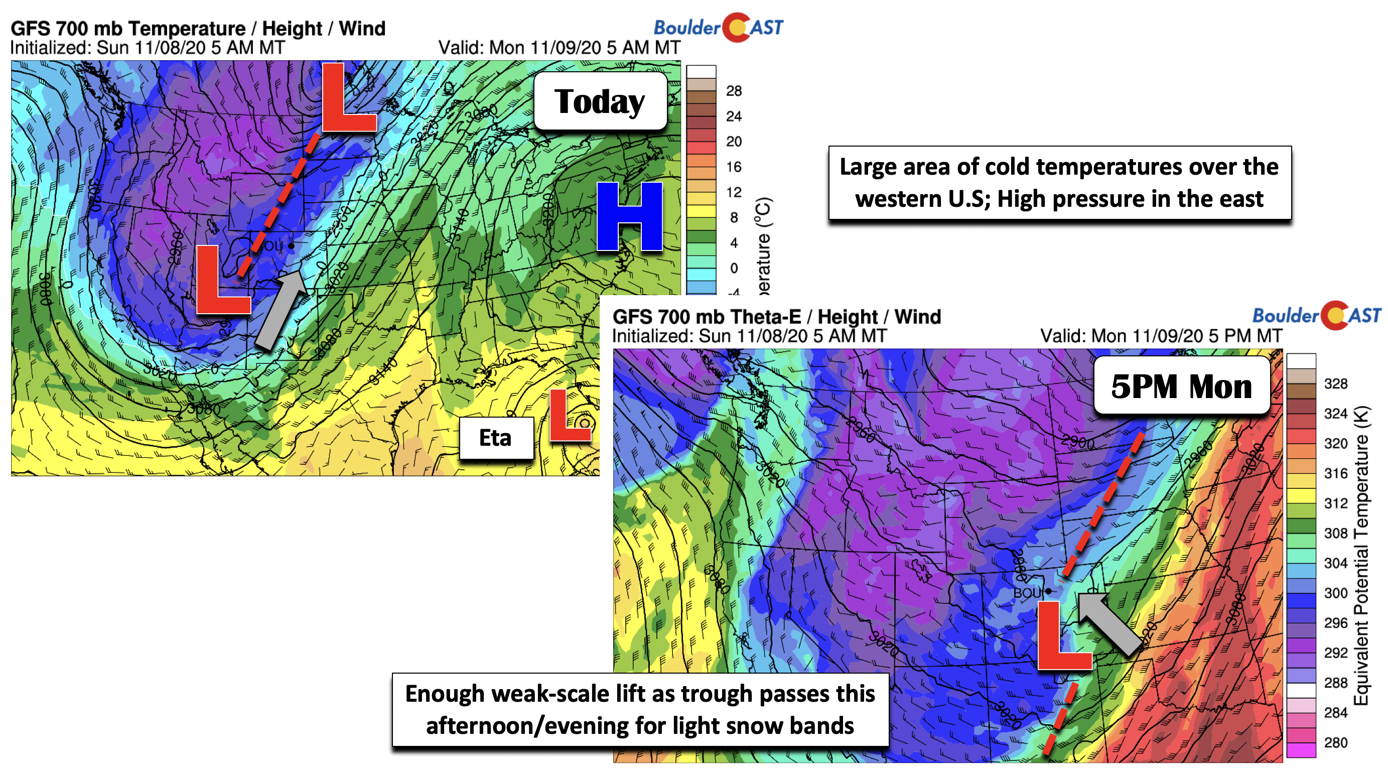
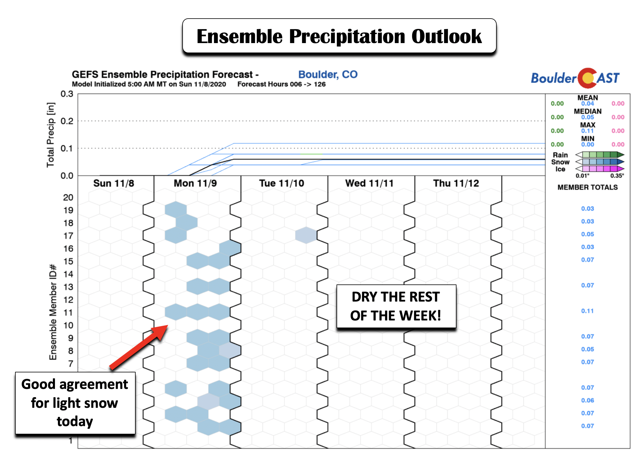
Much of the guidance, including ensemble predictions, have been quite consistent since the weekend that only light snow will shake-out today. That has not changed as of Monday morning (below), with good agreement of a short period of snow this afternoon/evening. However, after today, the rest of the week is looking completely dry! So if we can just get through this bit of winter weather, the rest of the week is looking much more pleasant, albeit still on the chilly side.
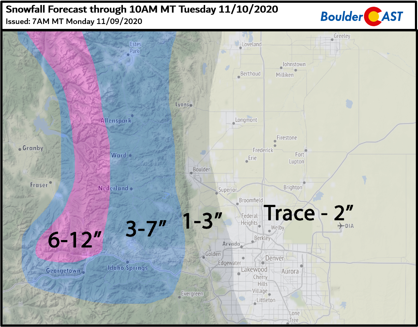
Ahead of the trough passage this afternoon, a cold front pushes through the Front Range this morning. Northeasterly surface winds, leading to upslope conditions, will keep temperatures in the middle 30’s during the day today (below right). Depending on which model guidance you look at, the amount of snow predicted ranges from just a trace to upwards of a few inches in some spots (below left; HRRR high-res model). The higher resolution models are showing the potential for a few brief period of moderate to heavy snowfall rates, mainly in the late afternoon into mid-evening hours .
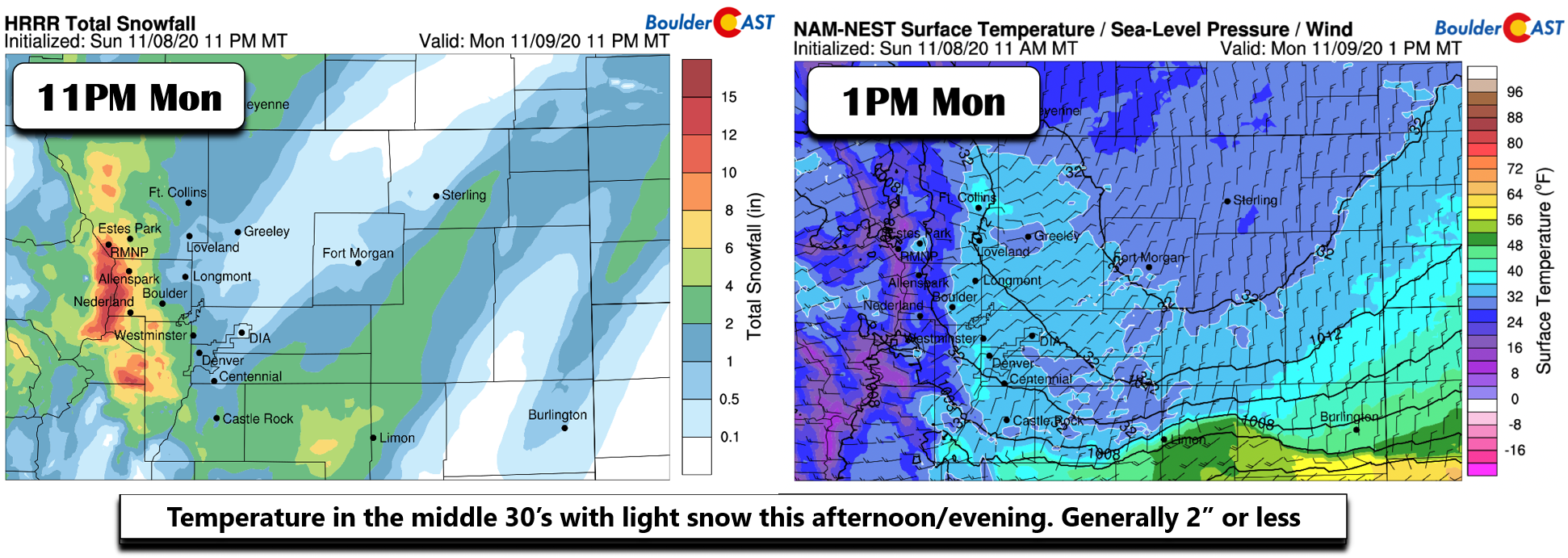
Expect light snow showers to develop through the day and continue into the evening, tapering off generally around midnight or so. There could be brief period of moderate snow mixed in, especially in the western suburbs and Foothills. Given that forcing is weak and that the upslope is not very deep, we believe most areas will see 2″ or less, with perhaps double this amount in the Foothills region west of the Metro area which could see a few hours of moderate snowfall. Temperatures will dip into the low and middle 20’s Monday night so bundle up if you have evening plans or early morning adventures on Tuesday.
Our snowfall forecast map for the event is shown below. This covers any snow falling through Tuesday morning.
Cool weather linger, but warmer by the weekend
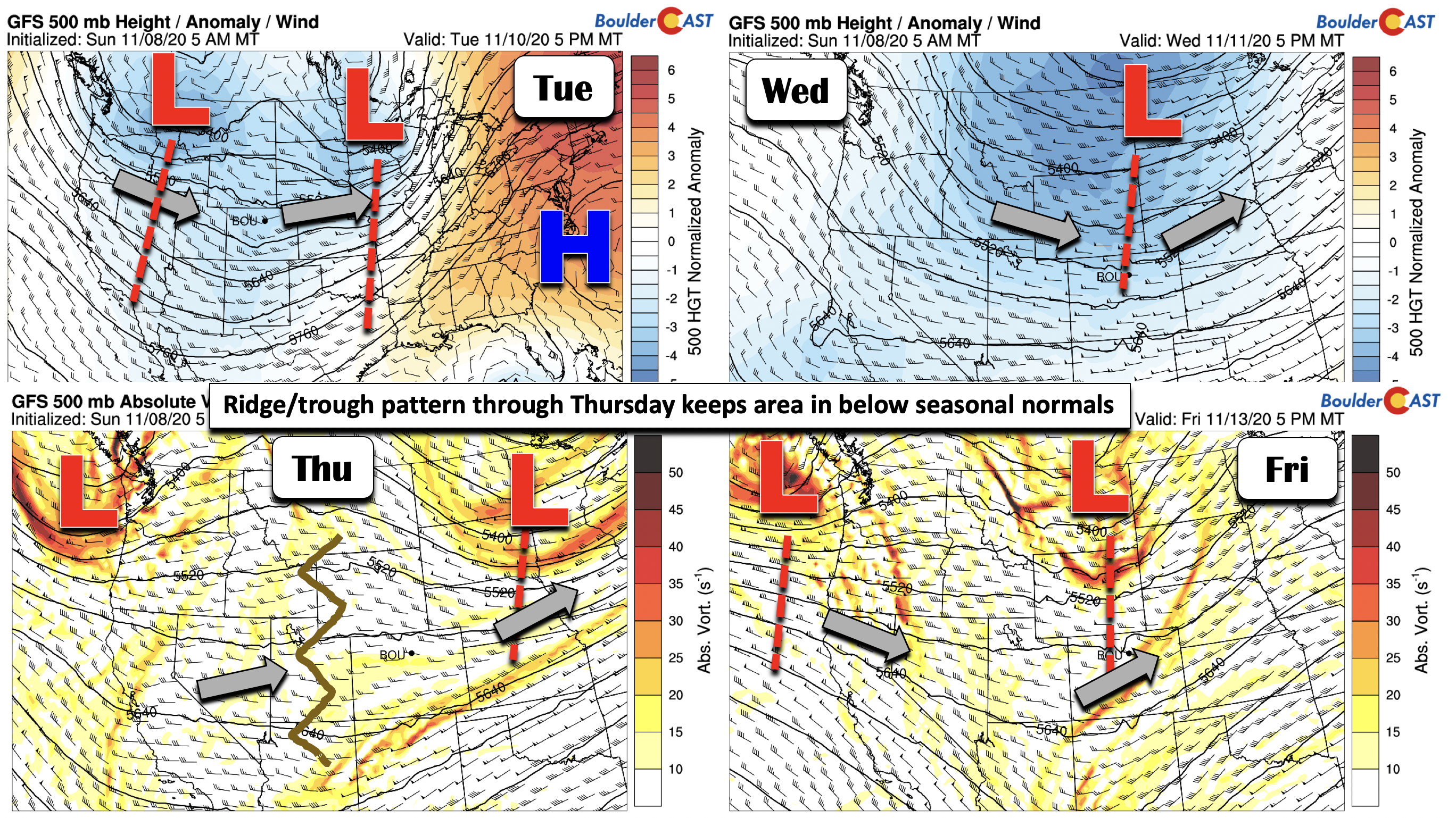
As mentioned previously, after today’s snow and cold, the rest of the week is going to be dry but with highs staying below average. Our normal high temperatures for this time of year are in the low to middle 50’s. The reason for our cooler stretch, at least through Thursday, is a series of troughs and ridges that will oscillate back and forth across the western U.S. The jet stream is thus active. By Tuesday(top left figure below), our snow-maker moves into Minnesota, but yet another storm is waiting in the wings over Idaho. A weak ridge develops Tuesday but is not enough to move the cold air out of eastern Colorado. On Wednesday (top right figure below), a new trough digs southward with an axis through Colorado. By Thursday (bottom left figure below), some weak ridging looks to develop, but yet another trough advances on Friday (bottom right figure below). What does this spell out for our weather? Well, really just a mix of clouds and sun interspersed throughout the week, along with temperatures in the low to middle 40’s early on, followed by a rise to the lower 50’s by week’s end. This warm-up come Friday is due to downslope winds allowing for a warmer airmass to take hold over eastern Colorado.
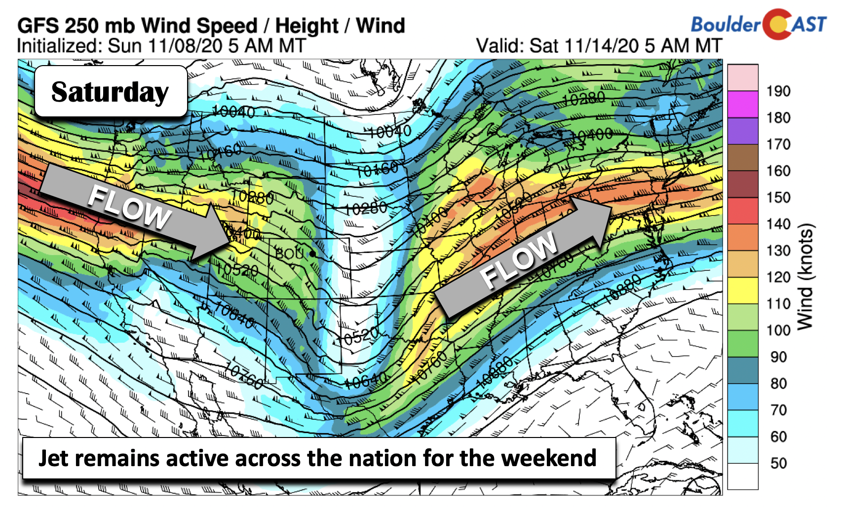
The rise to the lower 50’s by week’s end will mean we should be closer to average. These near normal temperatures will persist into the upcoming weekend. However, the jet stream will remain active (below). By Saturday, another jet streak will move onshore into the Pacific Northwest. While there are no major storms in sight yet in the extended, it will be something worth watching given the active setup.
Forecast Specifics:
Monday: Mostly cloudy skies with light snow showers through the day into the evening. Highs in the middle 30’s on the Plains and upper 20’s in the Foothills. Total snow accumulations up to 2″ across the lower elevations, with up to 6″ in the Foothills.
Tuesday: Morning sunshine giving way to increasing wave clouds in the afternoon. Temperatures near the lower 40’s on the Plains and middle 30’s in the Foothills.
Wednesday: Partly cloudy skies and still on the chilly side. Highs in the lower 40’s on the Plains and middle 30’s in the Foothills.
Thursday: A mix of clouds and sunshine with highs in the low to middle 40’s on the Plains and upper 30’s over the Foothills.
Friday: Increasing clouds with highs in the lower 50’s on the Plains and middle 40’s in the Foothills.
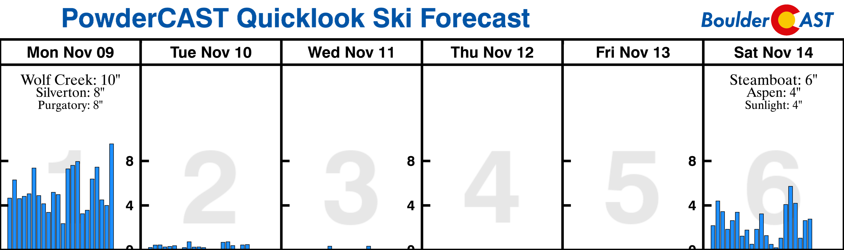
Mountains: Periods of snow will exist across the higher terrain on Monday thanks to the passing storm system. Northwest flow on Tuesday will lead to some lingering light snow showers, primarily over the northwest part of the state. Storm total accumulations from Monday into Tuesday will range from 4-10″. Drier weather takes over for the remainder of the week, but windy conditions are possible by week’s end with a new jet entering the picture. Find forecasts for all the Colorado ski resorts over at our PowderCAST page. Here’s a look at the snowfall outlook for the next six days:
Help support our team of Front Range weather bloggers by joining BoulderCAST Premium. We talk Boulder and Denver weather every single day. Sign up now to get access to our daily forecast discussions each morning, complete six-day skiing and hiking forecasts powered by machine learning, first-class access to all our Colorado-centric high-resolution weather graphics, bonus storm updates and much more! Or not, we just appreciate your readership!
.
Spread the word, share the BoulderCAST forecast!
.


You must be logged in to post a comment.