This week’s weather will be a mixbag across Colorado, with a little bit of Mountain snow, bouts of gusty winds, and one or two sizable temperature swings for the lower elevations. With the exception of a cold and windy Tuesday, the week ahead will be pretty nice for us overall. Looking ahead, a juicy atmospheric river may reach Colorado during the upcoming weekend with substantial Mountain snow in the works. Read on for all the details.
This week’s highlights include:
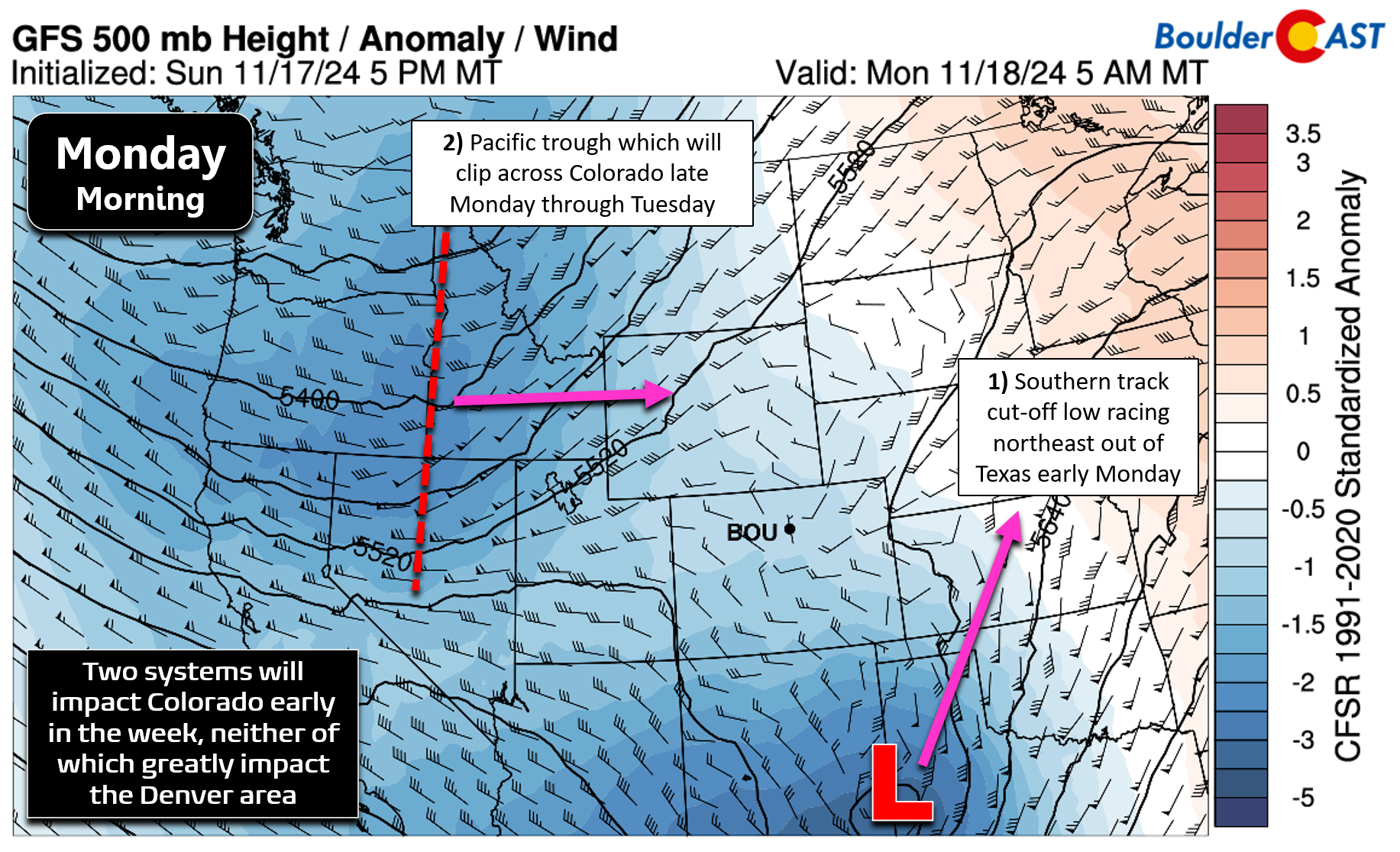
- An Active Early Week: Two weather features will impact Colorado early in the week — are a southern-track low pressure system and a Pacific trough. The southern system will bypass the Front Range, while the northern trough will bring light snowfall to the Mountains and a strong cold front to the Metro area
- Temperatures Tumble Tuesday: Monday will be mild with highs in the mid-50s, but a cold front will bring much colder temperatures on Tuesday, with highs only around 40 degrees and gusty winds.
- Mid-Week Ridge Develops Wednesday & Lingers: A ridge of high pressure will build over Colorado from Wednesday into the weekend, leading to quieter weather and gradually warming temperatures.
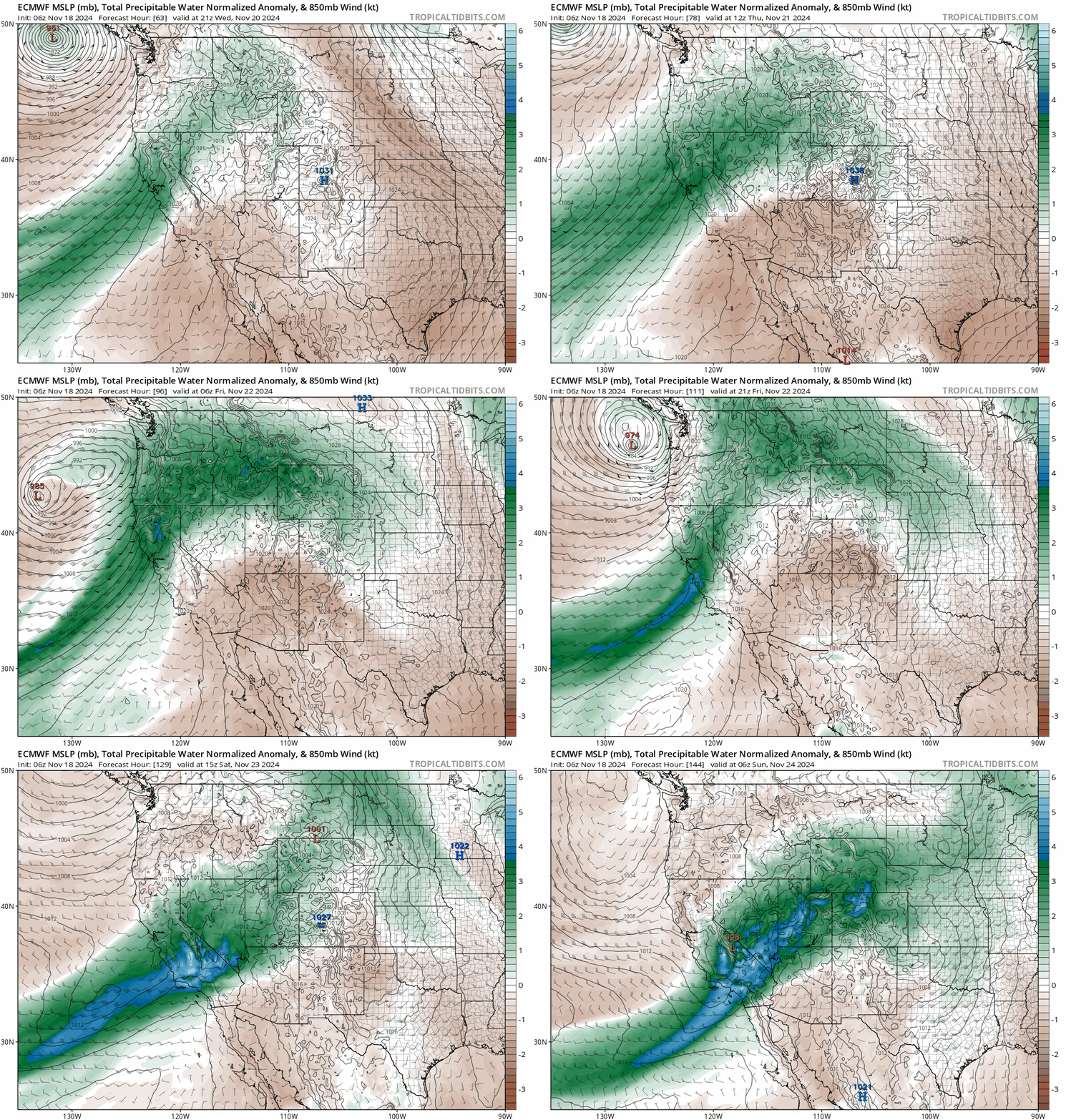
- Atmospheric River Brings Heavy Mountain Snow This Weekend: Temperatures should remain warm for Saturday, potentially reaching the mid to upper 60s in the Denver area. There is some uncertainty about a remnant atmospheric moving in and how it may impact the lower elevations. In general though, expect widespread moderate to heavy snow to break out in the Mountains as deep Pacific moisture flows in.
DISCLAIMER: This weekly outlook forecast is created Monday morning and covers the entire upcoming week. Accuracy will decrease as the week progresses as this post is NOT updated. To receive daily updated forecasts from our team, among many other perks, subscribe to BoulderCAST Premium.
Daily Forecast Updates
Get our daily forecast discussion every morning delivered to your inbox.
All Our Model Data
Access to all our Colorado-centric high-resolution weather model graphics. Seriously — every one!
Ski & Hiking Forecasts
6-day forecasts for all the Colorado ski resorts, plus more than 120 hiking trails, including every 14er.
Smoke Forecasts
Wildfire smoke concentration predictions up to 72 hours into the future.
Exclusive Content
Weekend outlooks every Thursday, bonus storm updates, historical data and much more!
No Advertisements
Enjoy ad-free viewing on the entire site.
Active early week, but little to show for it
We begin Monday under the gun of an active pattern across the western United States. However, active doesn’t always translate into much for our area which, whether you like it or not, is positioned in the rain (snow) shadow of the great Rocky Mountains. As of Monday morning, there are two weather features of concern across the region: 1) a southern-track cut-off low pressure racing northeast out of Texas and New Mexico which will only clip far east/southeast Colorado Monday morning as it pushes off into the Midwest, and 2) a Pacific trough passing across the northern Rockies that will do a bit more for us.
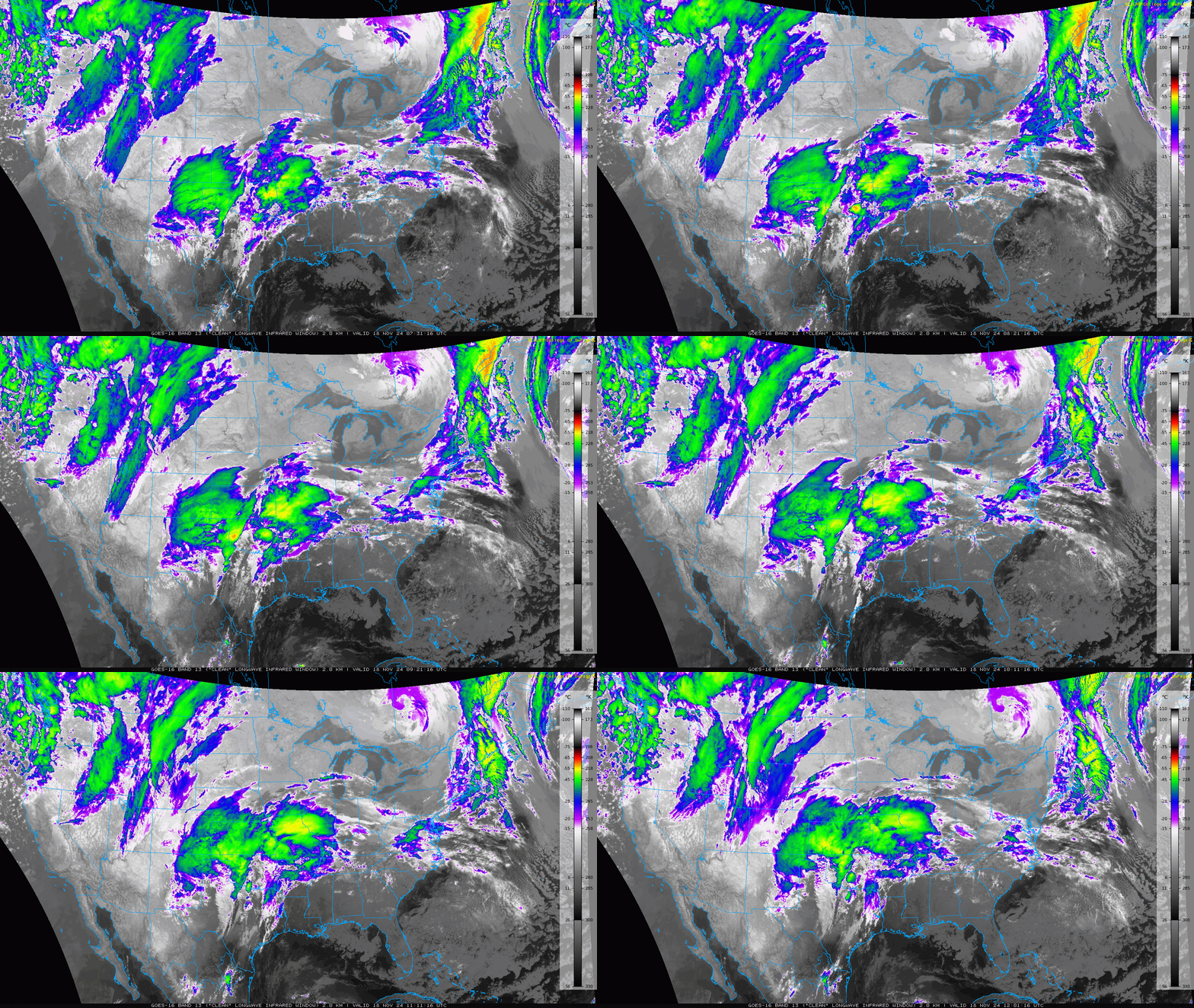
Both features of interest early this week are visible on Monday morning’s GOES-East infrared satellite animation shown below. The southern-track storm looks quite impressive, but it will definitely be bypassing the Front Range. We may see a few wispy high clouds low on the horizon streaming in from the east through our Monday, but otherwise this system will completely miss our area. The other feature, the trough coming across the northern Rockies right now, will bring more sensible impacts for us, but still nothing too bad.
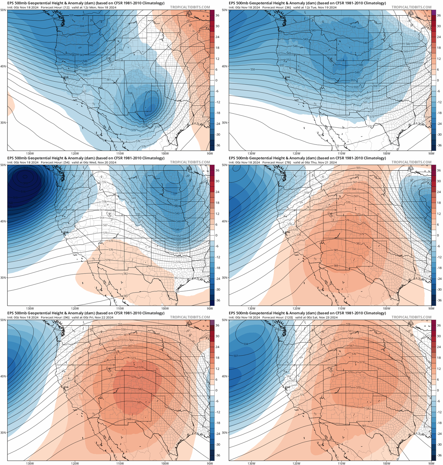
The European ensemble 500mb height animation below spans Monday through Friday. The northern stream trough will be consolidating along the Canadian Border Monday and Tuesday before moving east into the Great Lakes by Wednesday. In its wake, a persistent ridge will develop across Colorado Wednesday into the upcoming weekend. Thus, our semi-interesting weather will be front-loaded this week, with quieter times returning for the back half of the week.
The northern system’s cold front will move through the Front Range area Monday night, paving the way for a much colder and blustery Tuesday.
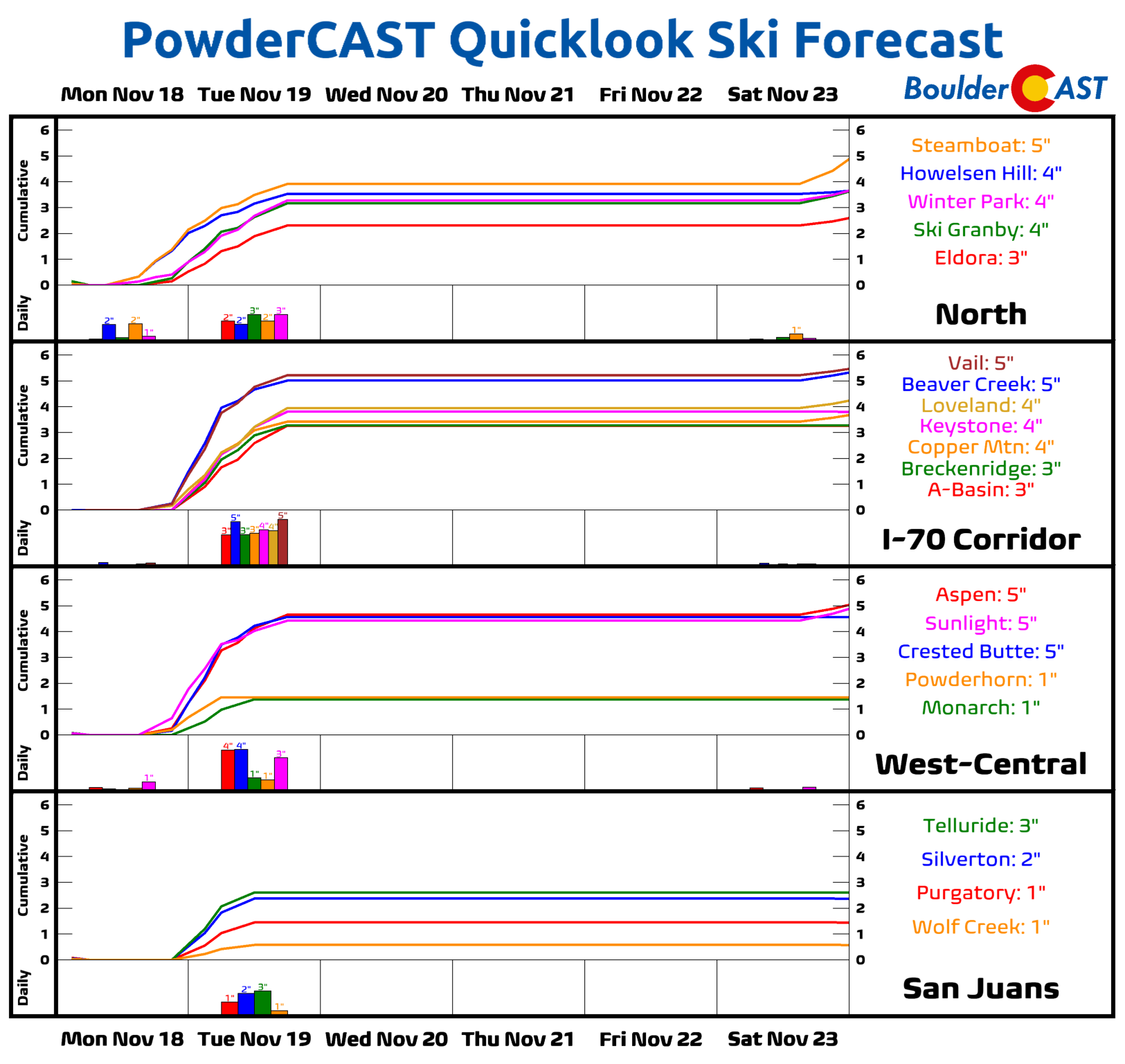
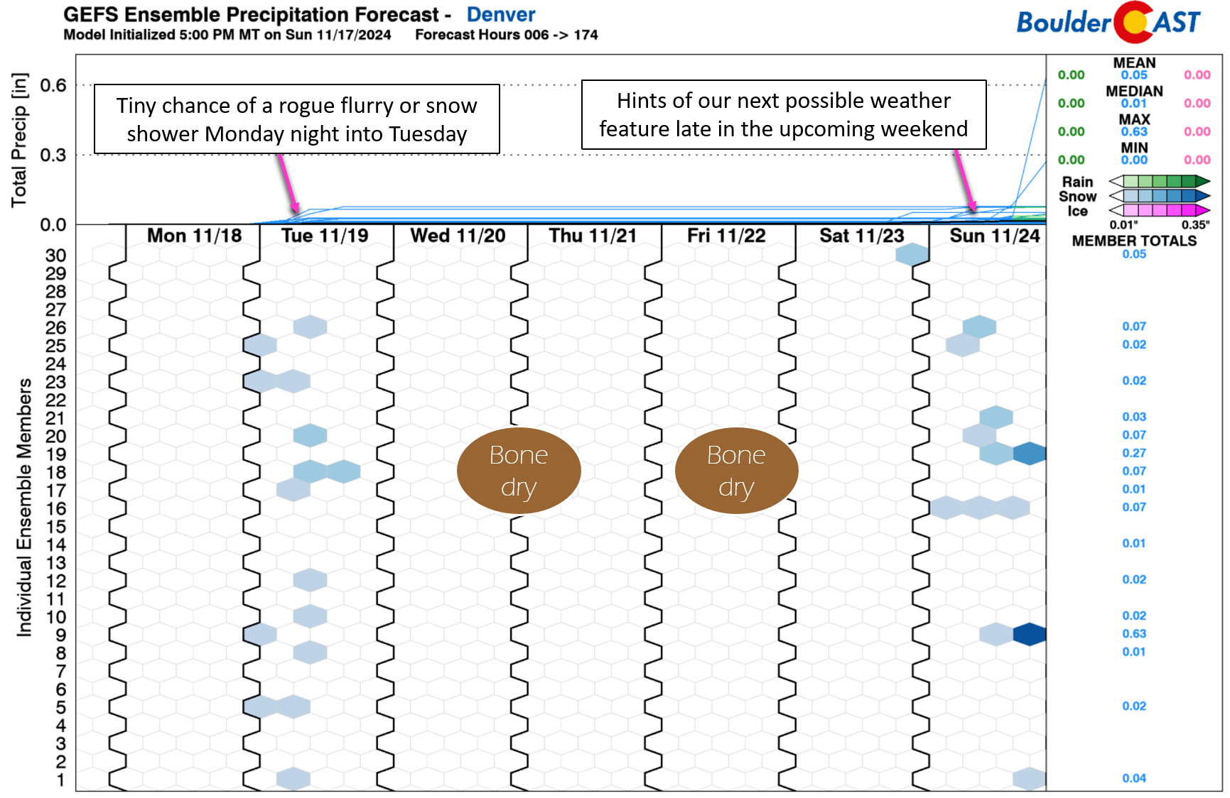
This system will produce light, orographic snowfall in the Mountains much of the day Monday through Tuesday leading to a few inches of accumulation. PowderCAST is predicting anywhere from 1 to 5″ of snow early this week across Colorado’s cornucopia of ski resorts, which we agree with. Northern Colorado will do best due to the proximity to the trough and its more favorable northwest flow orographics. While this trough was previously shown to dig a bit further south, which could have produced light snow accumulations across the Denver Metro area, that no longer is the case with a less pronounced and faster moving trough being favored. Still, there could be a few spotty snow showers on Tuesday east of the Mountains, but these would be very isolated and not lead to any accumulation.
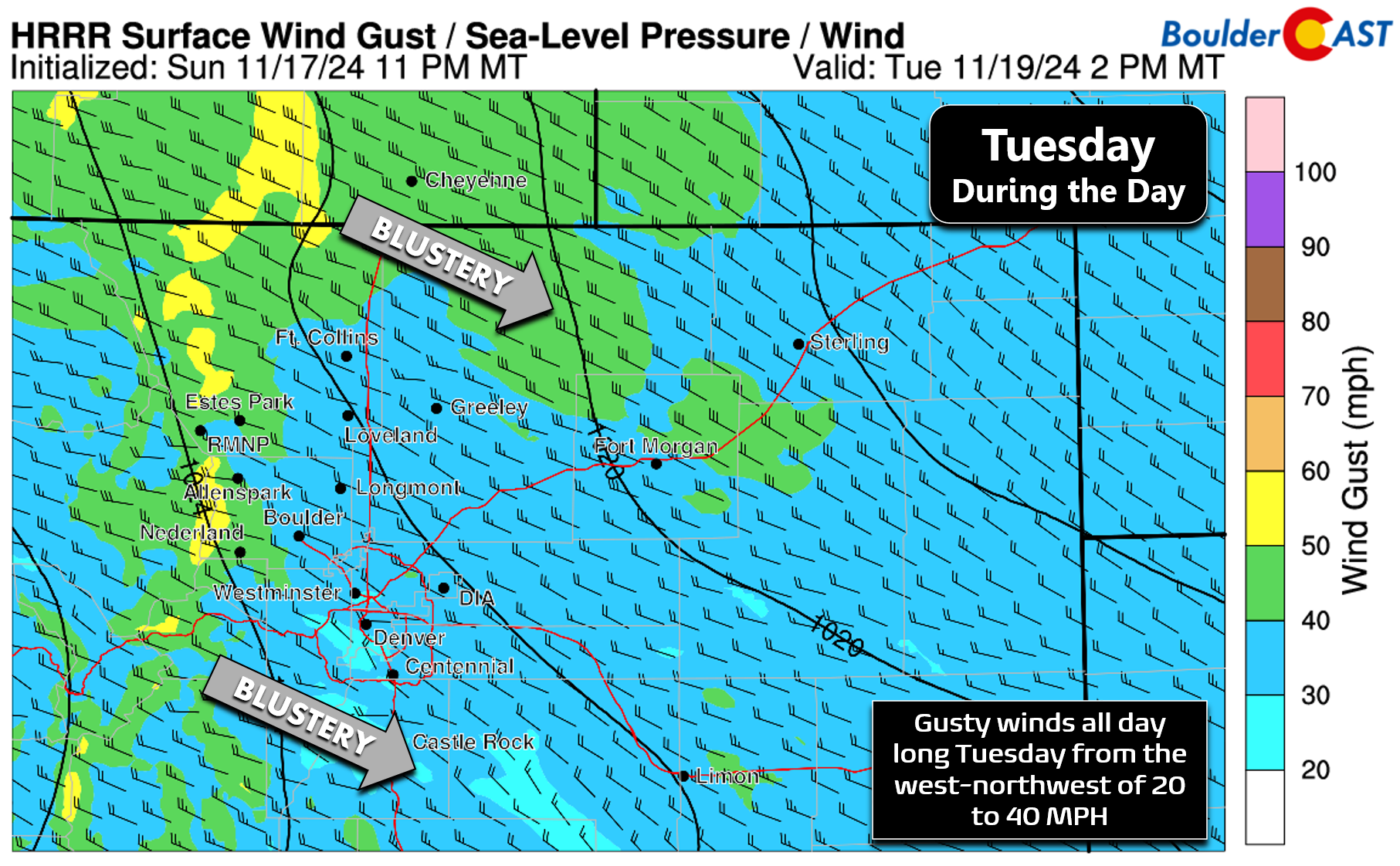
As the trough exists east, strong subsidence will push across the region on Tuesday with wind gusts of 20 to 40 MPH mixing down into the entire Boulder-Denver area, even higher in the Foothills and along the Wyoming Border. Plan for a blustery day!
After temperatures reach into the middle 50s on Monday, we’ll see notable cooling follow on Tuesday with highs expected to only be in the upper 30s to near 40 degrees with gusty west-northwest winds making it feel even colder!
A dry & quiet rest of the week
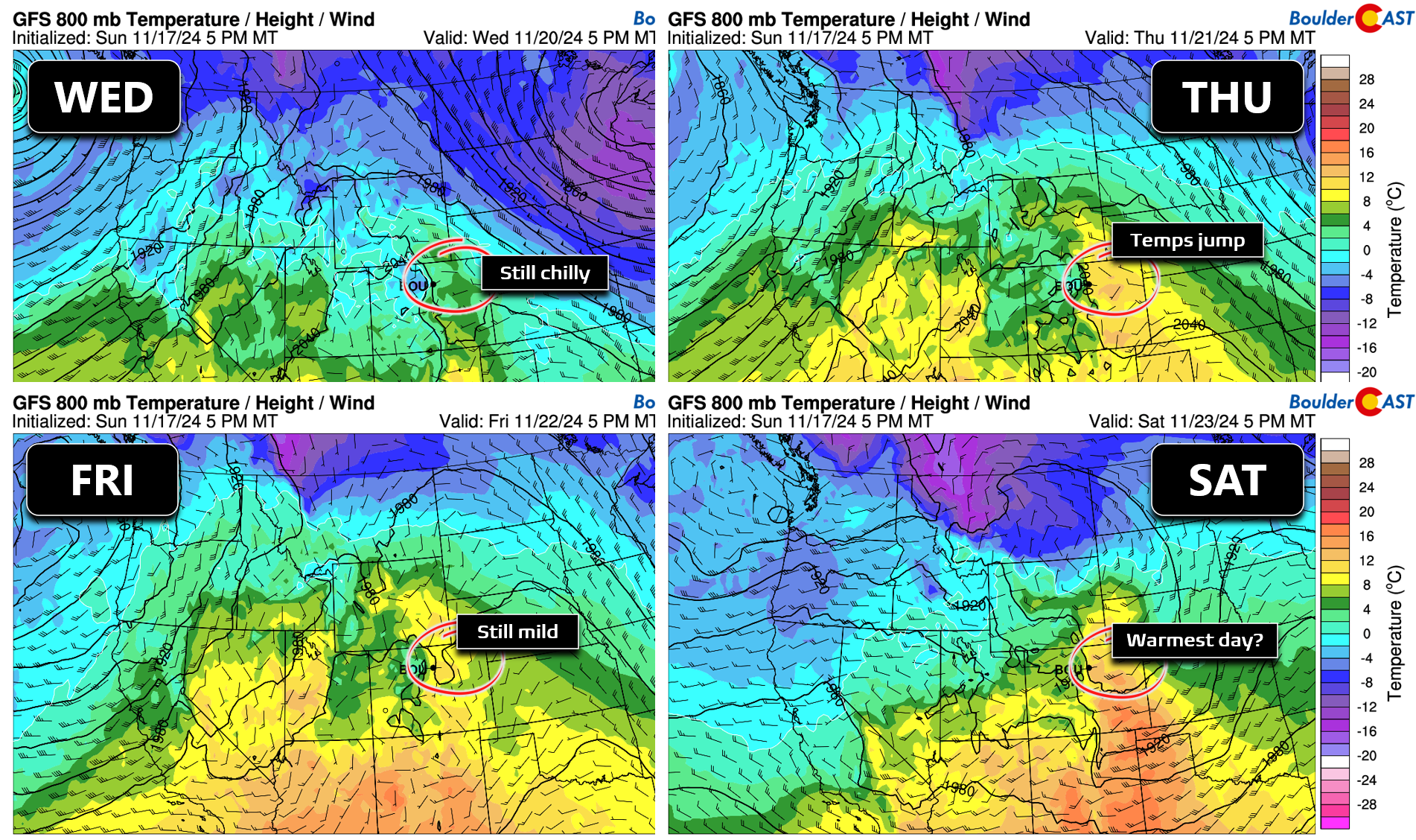
As mentioned earlier, the rest of the week will remain quiet in the Front Range as a ridge of high pressure builds directly over Colorado and lingers into the weekend. Temperatures will be slow to warm back up initially, only reaching near 50 degrees by Wednesday which is still slightly below normal. However, by Thursday and Friday, we’ll be pushing back towards the 60-degree mark or better — what a way to end the week! Saturday is shaping up to be very nice as well with perhaps middle 60s in the cards.
Some models are showing the ridge breaking down during the upcoming weekend or early next week as a powerful Pacific storm system comes ashore. There’s a lot of uncertainty, but our next chance of snow may not be too far off.
However, there’s not enough evidence to suggest anything significant for the lower elevations yet. If anything, the Mountains will likely get hammered with moderate to heavy snow thanks to an influx of Pacific moisture as part of a remnant atmospheric river. The latest Euro moisture anomaly forecast really looks promising with a narrow plume of moisture reaching Colorado during the upcoming weekend — after ravaging California beforehand of course…
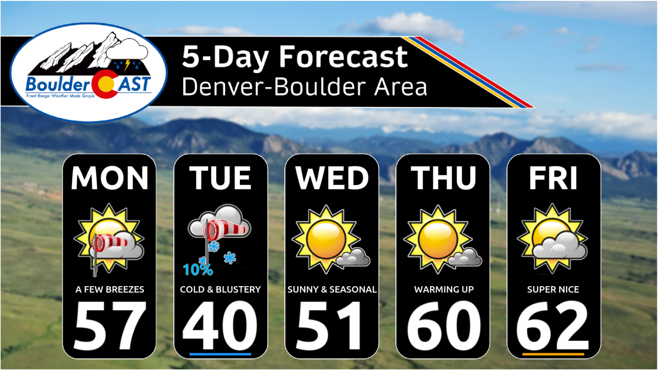
Our extended forecast graphic below shows the ups and downs expected over the next several days, including the cold and blustery Tuesday with a rogue snowflake or two possible. However, most of us will navigate through this week totally dry. Enjoy!
Forecast Specifics:
Monday: Partly to mostly sunny and seasonal with highs in the middle 50s on the Plains and middle 40s in the Foothills. Late-day breezes may gust up to 40 MPH in and near the Foothills. A cold front will move through Monday night with a few isolated snow showers possible, but no accumulation.
Tuesday: Possibly a few isolated morning snow showers, but otherwise partly sunny, cold and blustery. Highs will only be around 40 on the Plains with lower 30s in the Foothills. Winds will be whipping most of the day with gusts of 20 to 40 MPH from the west-northwest.
Wednesday: Quiet conditions return, as does the sunshine. Highs reach the lower 50s on the Plains with upper 30s in the Foothills.
Thursday: Warmer and mostly sunny with temperatures rebounding back to near 60 degrees on the Plains with upper 40s in the Foothills.
Friday: Staying warm with a mix of clouds and sun. High temperatures in the lower 60s on the Plains with near 50 in the Foothills.
Weekend: Saturday should be fairly warm pushing well into the 60s. Sunday is more uncertain with a new system possibly moving in, but it may also hold off or only impact the Mountains. Either way, we probably will start to see temperatures decrease in the Metro area.
Get BoulderCAST updates delivered to your inbox:
DISCLAIMER: This weekly outlook forecast is created Monday morning and covers the entire upcoming week. Accuracy will decrease as the week progresses as this post is NOT updated. To receive daily updated forecasts from our team, among many other perks, subscribe to BoulderCAST Premium.
Daily Forecast Updates
Get our daily forecast discussion every morning delivered to your inbox.
All Our Model Data
Access to all our Colorado-centric high-resolution weather model graphics. Seriously — every one!
Ski & Hiking Forecasts
6-day forecasts for all the Colorado ski resorts, plus more than 120 hiking trails, including every 14er.
Smoke Forecasts
Wildfire smoke concentration predictions up to 72 hours into the future.
Exclusive Content
Weekend outlooks every Thursday, bonus storm updates, historical data and much more!
No Advertisements
Enjoy ad-free viewing on the entire site.
Enjoy our content? Give it a share!






You must be logged in to post a comment.