After a very gusty weekend, you’ll be happy to know that warmer and calmer weather is on the way for much of the week ahead. High temperatures rise sharply back into the 60’s and even 70’s this week with lots of sunshine. However, winter weather could be right around the corner. Read on for our complete outlook of the week ahead.
This week’s highlights include:
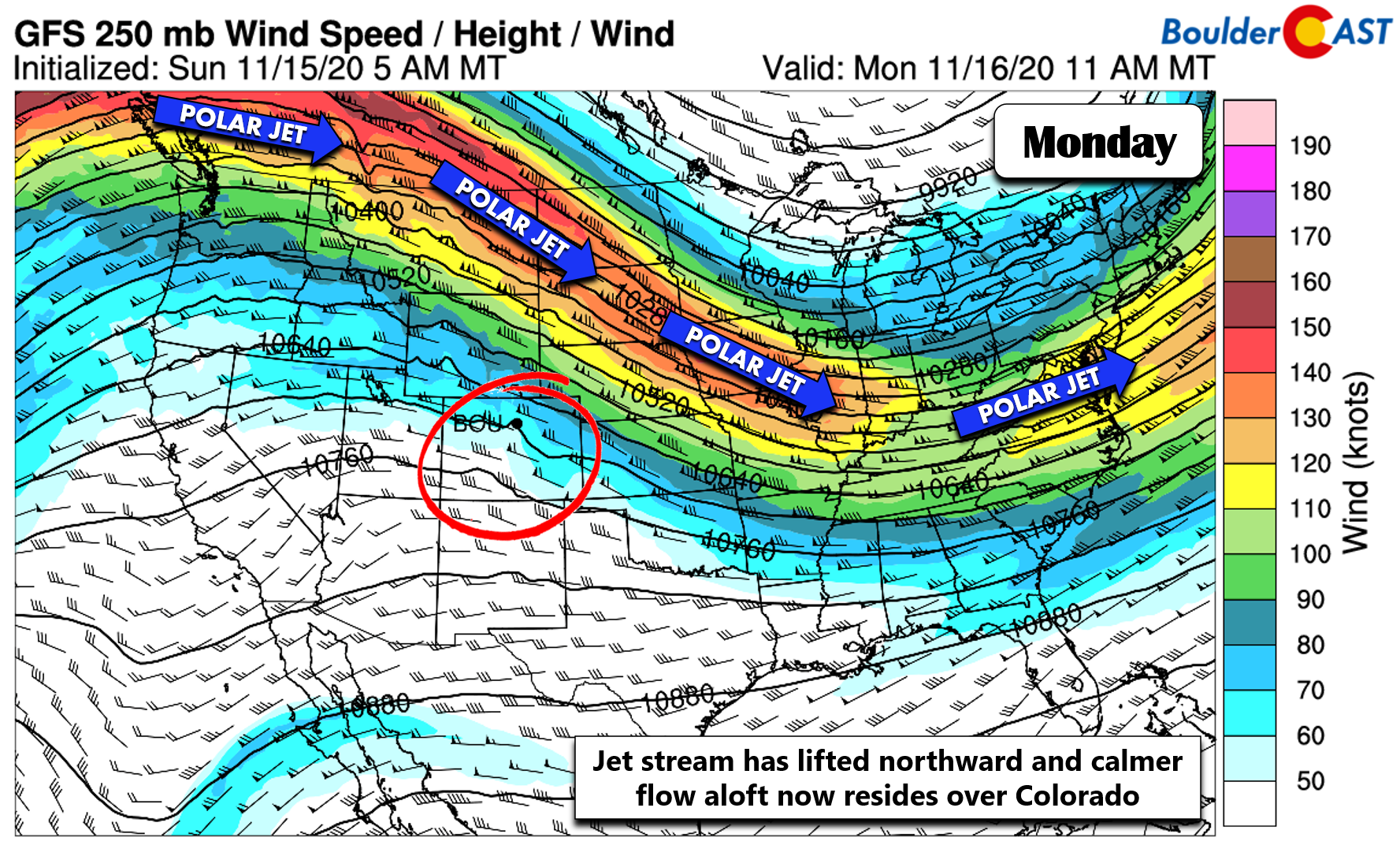
- Winds die down quickly as the jet stream exits northward
- A warm week is expected with temperatures in the 60’s and 70’s, lots of sunshine
- Winter weather is taking shape for late Friday into Saturday, but confidence is low in snow potential east of the Continental Divide
DISCLAIMER: This weekly outlook forecast is created Monday morning and covers the entire upcoming week. Accuracy will decrease as the week progresses as this post is NOT updated. To receive daily updated forecasts from our team, subscribe to BoulderCAST Premium.

Warm & tranquil most of the week
Another week, another period of painfully boring weather for the Front Range. The jet stream which made for a very blustery weekend has finally pushed northward and out of Colorado (see below).
With the jet overhead and favorable atmospheric conditions to bring these strong winds down to ground level, peak wind gusts were impressive to say the least across the region. Here’s a look at the maximum wind gusts from over the weekend.
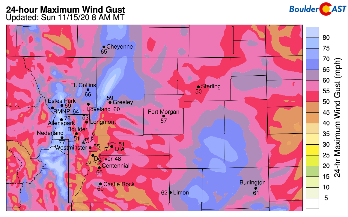
Peak gusts from the weekend around the area
Just about everywhere saw gusts at times above 50 MPH. The strongest gusts were reported in the vicinity of Boulder and topped 80 MPH!
Here's a look at the wind gusts over the past 24 hours. Almost all of our forecast area saw wind gusts of 50-60mph, and a station 3 miles south of Boulder recorded an 85mph gust this morning! #cowx pic.twitter.com/A9peE9Nrjx
— NWS Boulder (@NWSBoulder) November 15, 2020
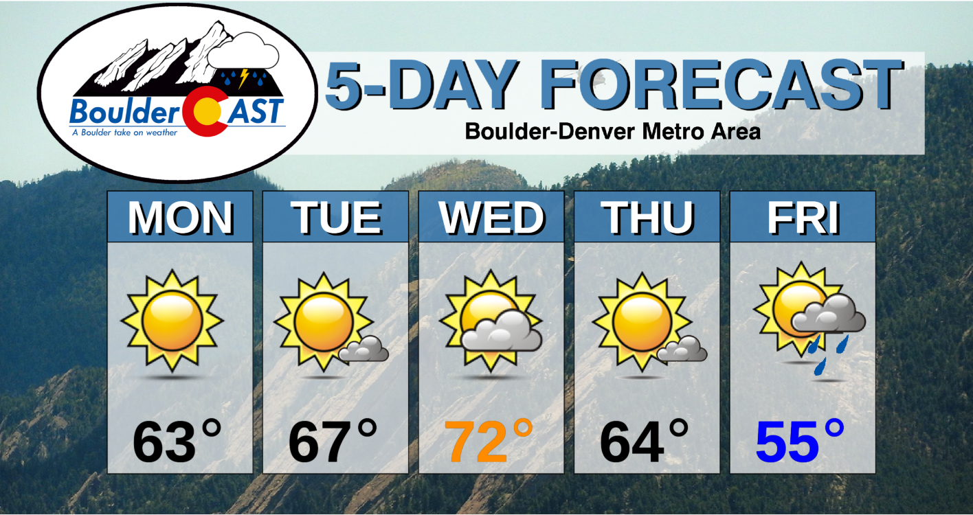
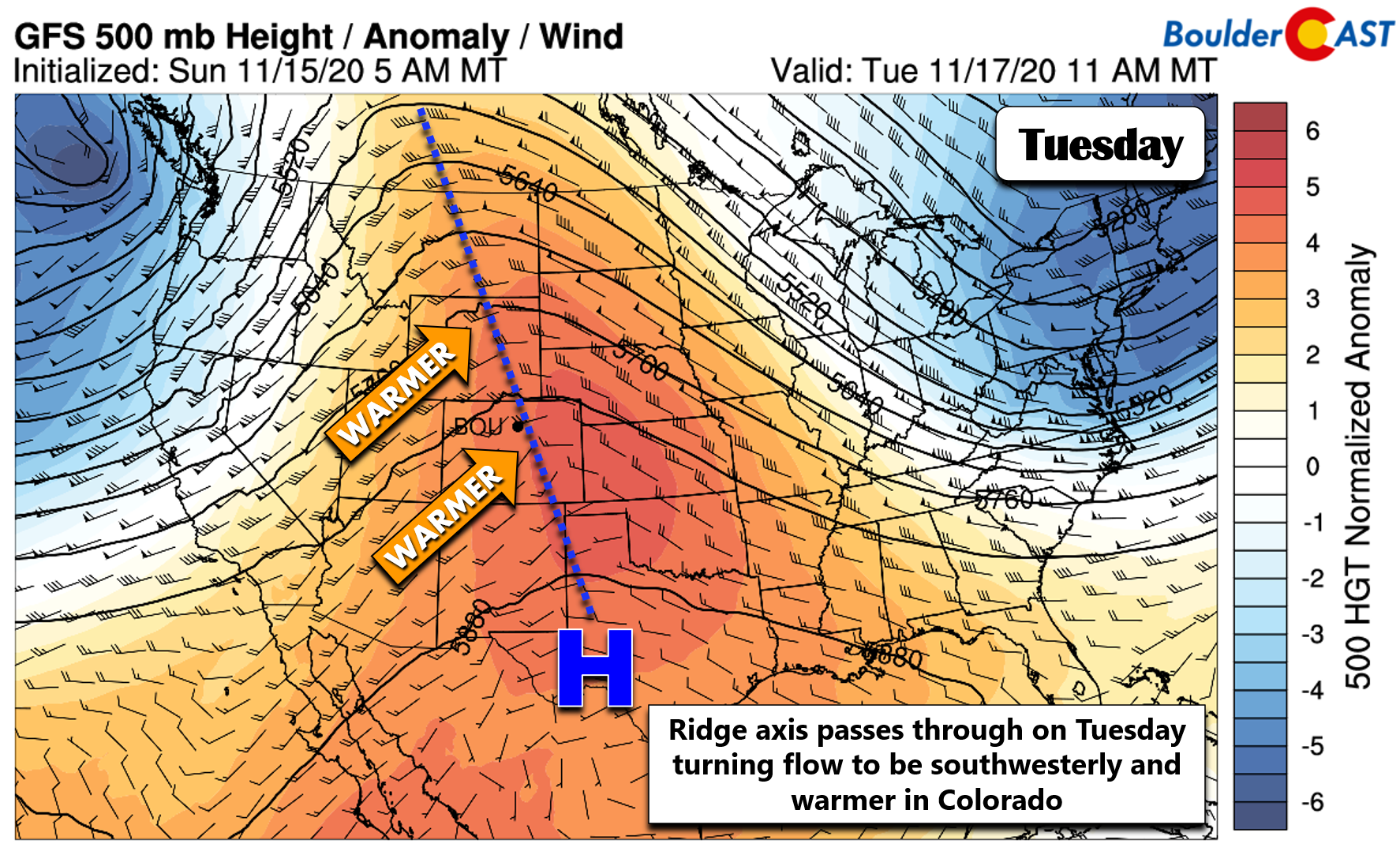
For the week ahead, it will be much calmer and as we mentioned earlier, somewhat on the boring side. High pressure and ridging will build into the state Monday through Wednesday leading to generally tranquil conditions statewide. The story of the week will be the temperatures as downslope warming takes hold and flow eventually turns southwesterly aloft as a ridge axis passes through (see below).
Temperatures across the Front Range will be above normal throughout the week, though the warmest day looks to be Wednesday with highs pushing into the lower to perhaps middle 70’s. Slightly cooler conditions are indicated for Thursday and Friday but highs should still remain somewhat mild in the 50’s to lower 60’s.
Late week snow potential
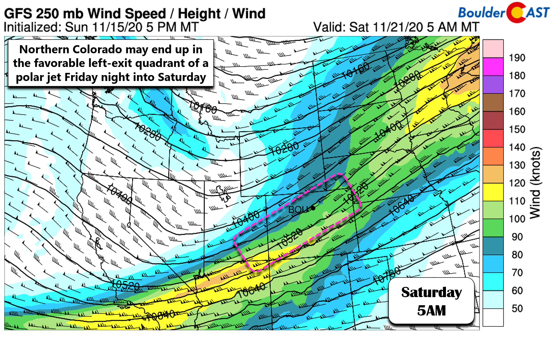
Our next weather system will arrive late in the week ushering in unsettled conditions to the region. A Pacific trough will aid in producing another period of moist southwest flow followed by moist northwest flow in Colorado. The weather models are still diverging on how strong and quick-moving this system will be, but early signs point towards another weak one with mainly mountain snow and possibly some rain and snow across the Plains as well. The main forcing mechanism with this system will be the overhead jet stream, with portions of Colorado residing in the favorable left-exit region of a small polar jet streak. There is very little to no easterly upslope indicated by the models right now, so potential snow amounts east of the Divide will depend greatly on the position of this tiny jet feature. As such, this forecast is highly uncertain right now but will definitely be something to watch through the week.
The first chances for precipitation across the Denver Metro area with this system could arrive as early as Friday evening in the form of rain showers.
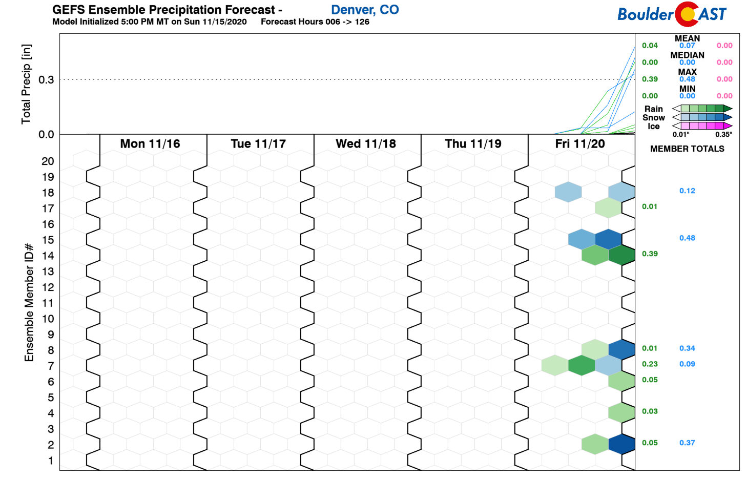
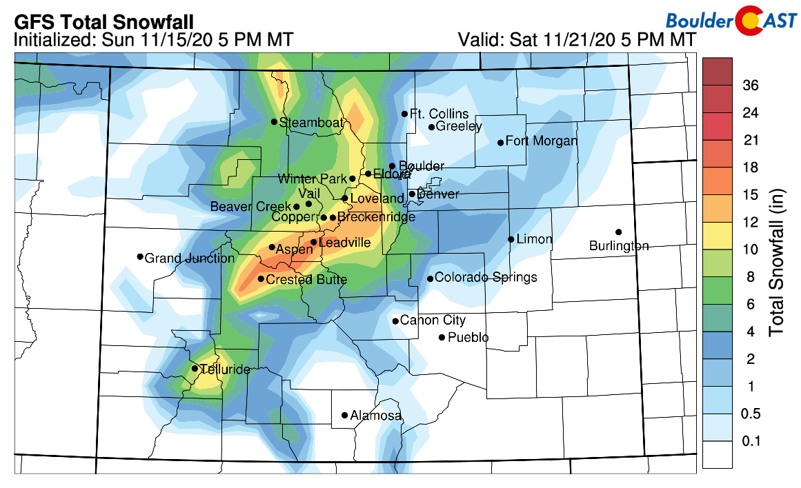
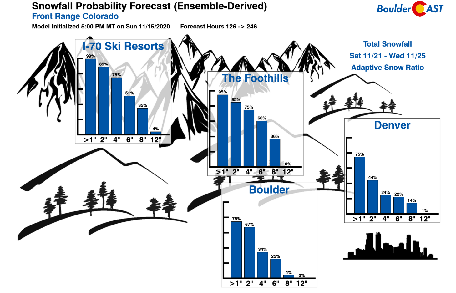
With temperatures cooling Friday night into Saturday, the precipitation type would likely change over to snow, with some accumulation not out of the question in Boulder and Denver. We’ll need to see how things shake out as the week progresses with the jet and overall storm intensity, but this will probably be a mostly mountain snow event. The latest GFS model-derived snowfall forecast through Saturday evening is shown below.
Our latest Snowfall Probabilities do point to the potential for larger totals, even across the lower elevations, but we do caution how much this depends on the jet’s positioning. Check back through the week for updates on the winter weather potential. It’s too early to call right now.
Finally, keep the Central American country of Nicaragua in your thoughts today as Category 4 Hurricane Iota bears down and makes landfall later this afternoon. This is almost the exact same track that Category 4 Hurricane Eta took less than two weeks ago which caused devastating flooding and deadly mudslides in the area. Iota is now flirting with the record for the most potent Atlantic hurricane ever to exist in November which would be just another notch in 2020’s belt…
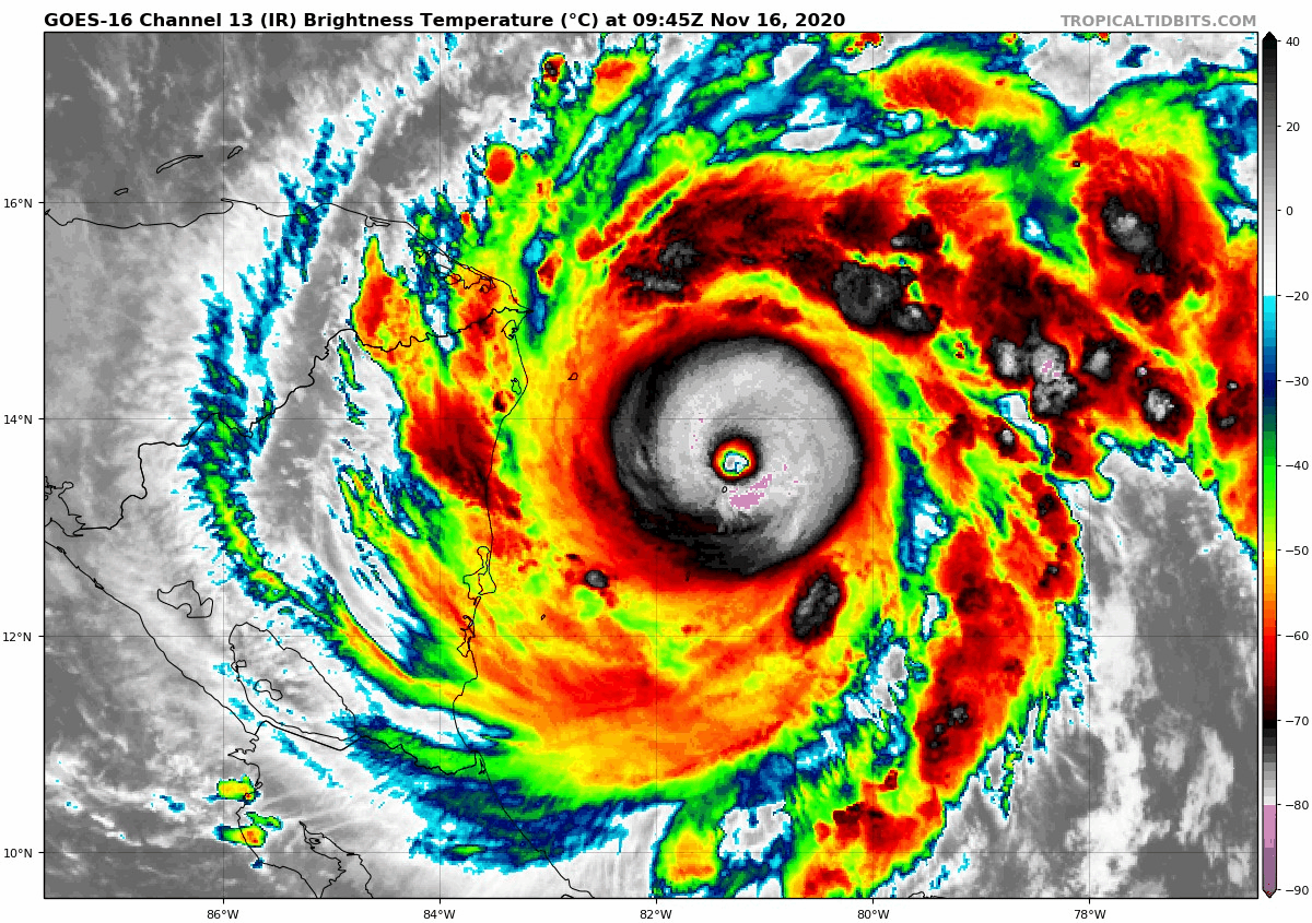
GOES-East infrared satellite animation of Cat 4 Hurricane Iota from Monday morning.
Forecast Specifics:
Monday: Sunny, mild and breezy. Highs in the lower 60’s on the Plains and upper 40’s in the Foothills.
Tuesday: Mostly sunny and mild. Temperatures in the middle 60’s in the Plains and lower 50’s in the Foothills.
Wednesday: A mix of wave clouds and some sunshine, but quite warm. High temperatures in the lower 70’s on the Plains and upper 50’s in the Foothills.
Thursday: Mostly sunny, mild, and continued dry. Temperatures cooler in the lower 60’s across the Plains with upper 40’s in the Foothills.
Friday: Partly cloudy and cooler with highs in the 50’s on the Plains and 40’s in the Foothills. There will be a slight chance of rain showers across the Plains late in the day with our next storm system arriving. Some snow showers in the higher Foothills.
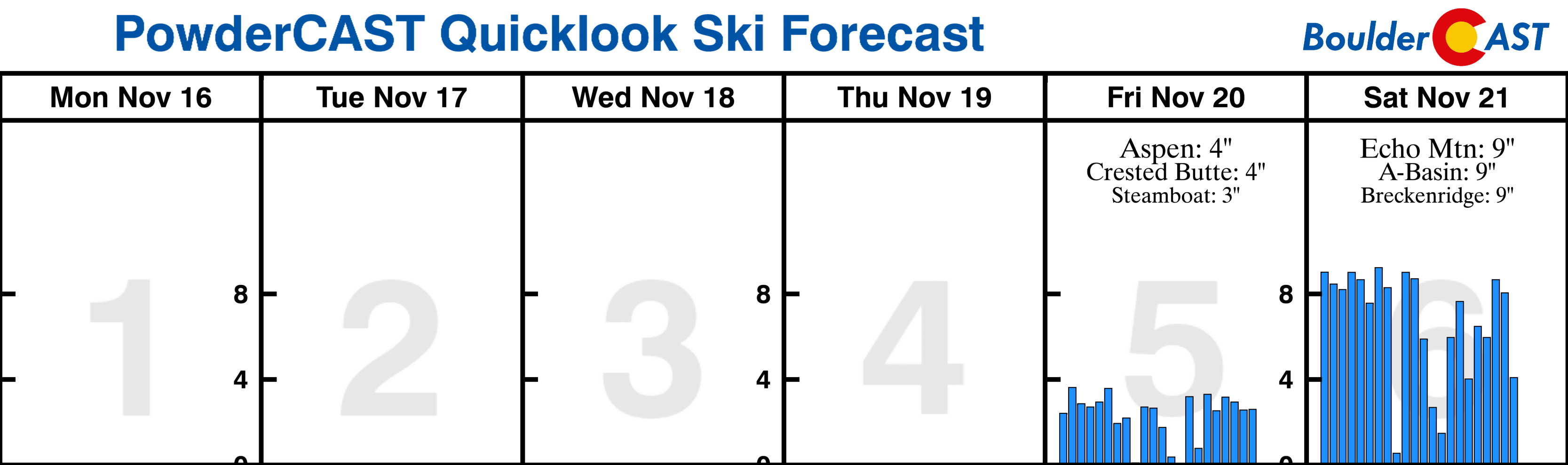
Mountains: It will be dry across the mountains through the week with overall mild conditions and mixtures of clouds and sun statewide. Winds will relax as well in many areas. The next storm system will spread rain/snow to the San Juans Thursday night and across the rest of Colorado’s mountains on Friday. Many ski resorts could see a broad brush of 6 to 12″ of new snow from this system, but confidence is somewhat low right now. Find daily updated forecasts for all the Colorado ski resorts over at our PowderCAST page.
Help support our team of Front Range weather bloggers by joining BoulderCAST Premium. We talk Boulder and Denver weather every single day. Sign up now to get access to our daily forecast discussions each morning, complete six-day skiing and hiking forecasts powered by machine learning, first-class access to all our Colorado-centric high-resolution weather graphics, bonus storm updates and much more! Or not, we just appreciate your readership!
.
Spread the word, share the BoulderCAST forecast!
.


You must be logged in to post a comment.