
We begin very cold, rainy and snowy for some, but things will improve through the week slowly with a chance at hitting 80 degrees again by week’s end. Overall, though, the week remains fairly unsettled which is typical for this time of year and is welcomed considering the lingering drought. Let’s take a look at the forecast.
This week’s highlights include:
- A very cold and soggy Monday with widespread rain lingering through the day and even into the evening for upslope-favored spots
- Staying cool and somewhat unsettled Tuesday and Wednesday with two weaker disturbances moving across Colorado
- A ridge develops for Thursday and Friday with temperatures getting back into the 70’s to near 80 degrees
- Another spring storm may be gearing up for the weekend ahead, but still too early to say for sure

DISCLAIMER: This weekly outlook forecast is created Monday morning and covers the entire upcoming week. Accuracy will decrease as the week progresses as this post is NOT updated. To receive daily updated forecasts from our team, subscribe to BoulderCAST Premium.

A soggy Monday!
As of 7:00 AM Monday, around 1″ of rain has already fallen across much of the Front Range, with a few inches of snow above 7500 feet in the Foothills. Radar is showing essentially 100% coverage of precipitation across the area, so wherever you may be, it’s most likely raining or snowing right now this morning!
On Sunday, we had strong thunderstorms develop across the area as the initial cold front approached from the west. The first storm formed just west of Boulder producing pockets of relatively small hail, gusty winds, heavy rain, and lots of thunder!
Well that storm blew up quickly. Brief heavy rain, lightning and small hail moving through Boulder and areas east now or very soon! #cowx #hail pic.twitter.com/5B4Tbz18cC
— BoulderCAST Weather (@BoulderCAST) May 2, 2021
Our weather will improve very little on Monday as the best ingredients for precipitation are still very much in-place. The trough and parent storm system are located to the west near the Four Corners (below left). This puts most of Colorado in a favorable location for weak large-scale lift. This system will slowly migrate eastward through the day Monday into Monday night keeping the gloom locked-in for another day. Furthermore, the strongest, deepest and coldest upslope recently arrived after midnight last night and will linger through all of Monday before shutting down in the late evening hours tonight (below right). These factors will help to keep widespread light to moderate precipitation going across the Front Range through most of Monday and even into Monday night for the most upslope-favored areas of Boulder and Jefferson Counties.

We’re sitting at 38°F at BoulderCAST Station right now with moderate rainfall as of 7:00AM. With the clouds and precipitation socked in today, temperatures won’t budge much at all. We’re looking at highs only in the low to middle 40’s in most areas, with perhaps upper 40’s in spots that manage to dry out a little further east and away from the terrain.

We mentioned it earlier, but here’s a look at the precipitation totals through ~7:00 AM Monday. Most areas have already seen between 0.75″ and 1.5″ of liquid!

This storm still has a lot of life left and will dump another 0.25 to 1.0″ of liquid by the time it moves out Monday night. This will solidify moisture totals of 1-2″ for the area!

GFS storm total precipitation forecast. As of Monday morning, around 1/2 of this had already fallen.
Where it is colder higher up, snow will continue to fall through the day Monday. Snow levels Monday morning will bottom out around 6500-7000 feet. With the very potent May sun rising soon, snow levels will creep up slightly through the day with any travel impacts in the Foothills diminishing as roadways quickly melt out from the minor overnight accumulations. Even with falling snow through much of the day, little additional accumulation is expected in the Foothills as melt rates begin to eclipse snowfall rates. Our snowfall forecast map included in Sunday’s forecast is still applicable and is shown below.

Seasonally unsettled Tuesday and Wednesday
After the main storm system moves out Monday night, Tuesday and Wednesday will be somewhat quieter but still unsettled due to a pair of weak disturbances embedded in the northwest flow. Temperatures will top out around 60 degrees both days with slight chances for rain showers with a few rumbles of thunder (10-30%).
Warming up late-week
Later in the week, a large ridge of high pressure will quickly develop and just as rapidly push east of our area. Despite the brevity, we should be able to squeeze out two relatively nice and warmer days Thursday and Friday.
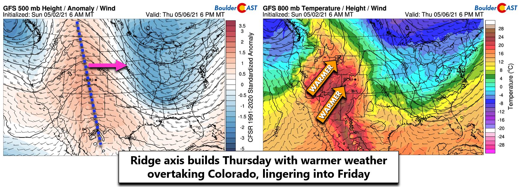
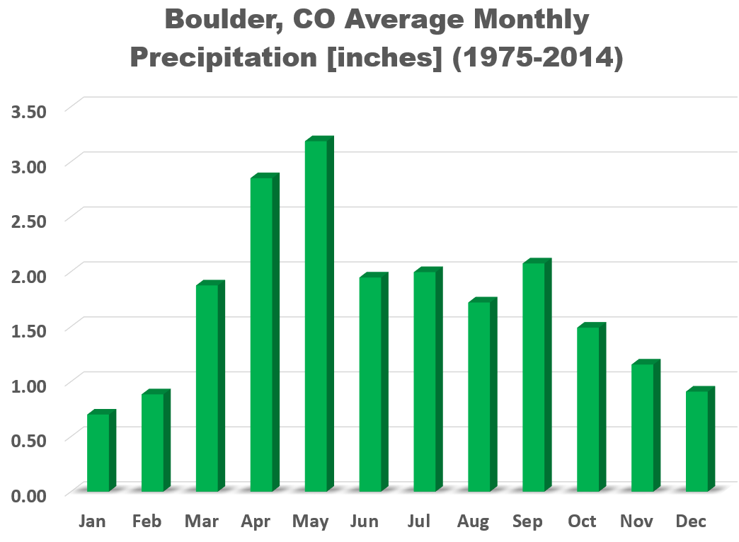
High temperatures Thursday will be in the 70’s with then a chance at hitting 80 degrees on Friday. Another storm system will follow the ridge with cooler and unsettled weather expected for the upcoming weekend. There is some uncertainty in the timing of that system and when the associated cold front might arrive to the Front Range. Current model trends have the front arriving Friday evening or night. If it comes in a little earlier, the chance of hitting 80 degrees Friday might go up in flames…a little later and Saturday could be fairly nice, too. Either way, it’s definitely a relief to see the pattern remaining active in what is typically our wettest month of the year. We need the moisture!
Stay up to date with Colorado weather and get notified of our latest forecasts and storm updates:
We respect your privacy. You can unsubscribe at any time.
Forecast Specifics:
Monday: Gloomy and rainy most of the day on the Plains with snow above 7000 feet elevation. Some snow could mix at times as low as 5500 feet with no accumulation. Rain/snow will linger into Monday evening and night in spots. Highs in the middle 40’s on the Plains and low to middle 30’s in the Foothills. Additional snow accumulations of up to 2″ in the Foothills expected.
Tuesday: Partly cloudy with a chance of afternoon/evening rain showers and maybe a rumble or two of thunder. Highs in the upper 50’s on the Plains and in the middle 40’s in the Foothills.
Wednesday: Partly to mostly sunny with widely scattered afternoon/evening showers and storms. Highs in the lower 60’s on the Plains with upper 40’s in the Foothills.
Thursday: Sunny, warmer and dry with temperatures in the lower 70’s on the Plains and upper 50’s in the Foothills.
Friday: Partly cloudy and perhaps a little gusty with highs near 80 degrees across the Plains with upper 60’s in the Foothills.
Mountains: Light snow will continue during the day Monday with additional accumulations less than 2″ expected in the peaks, except along the Continental Divide where up to 5″ could fall. Rain/snow showers will be possible Tuesday and Wednesday afternoons (no accumulation). Thursday and Friday will be warmer, drier and sunnier in the Mountains.
Help support our team of Front Range weather bloggers by joining BoulderCAST Premium. We talk Boulder and Denver weather every single day. Sign up now to get access to our daily forecast discussions each morning, complete six-day skiing and hiking forecasts powered by machine learning, first-class access to all our Colorado-centric high-resolution weather graphics, bonus storm updates and much more! Or not, we just appreciate your readership!
.
Spread the word, share the BoulderCAST forecast!
.


You must be logged in to post a comment.