
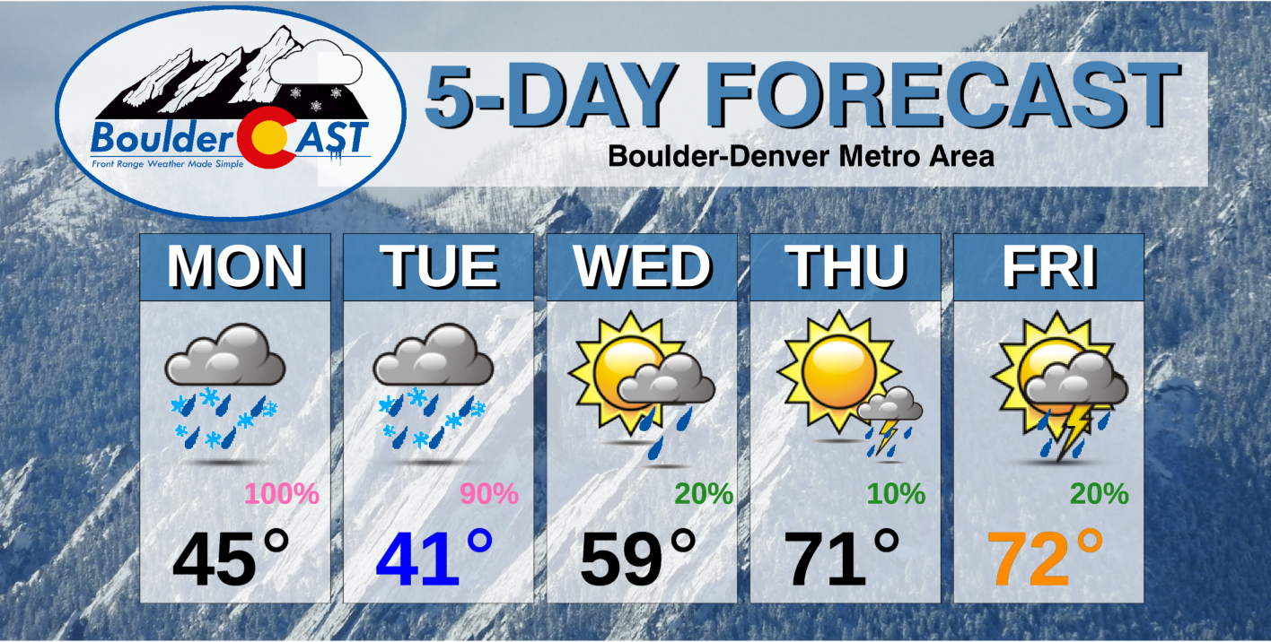
Get ready! There will be a rather unsettled and cold start to the week as a spring low pressure circulates across the state Monday into Tuesday. Temperatures even drop cold enough to support a change-over to late-season snow in Boulder and Denver Monday night! We discuss expected snowfall amounts through Tuesday and provide our final snowfall forecast map. Drier and more seasonal temperatures will close out the rest of the week.
This week’s highlights include:
- A circulating area of low pressure sits over Colorado through Tuesday, bringing rain/snow to much of the state
- Light accumulations possible on the Plains, but up to a foot in the Foothills by Tuesday night
- Sunshine redevelops Wednesday
- Drier and more seasonal to end the week, though watching for some isolated storms
DISCLAIMER: This weekly outlook forecast is created Monday morning and covers the entire upcoming week. Accuracy will decrease as the week progresses as this post is NOT updated. To receive daily updated forecasts from our team, subscribe to BoulderCAST Premium.

Rain and snow aplenty!
Below shows the infrared satellite image as of Monday morning at 6AM. Low pressure over western Montana has brought a moist flow regime into Colorado. This area of low pressure will slowly make its way south into the state and be with us through Tuesday, bringing rounds of rain and some snow for the region. We’ll detail expected amounts as this system traverses the Colorado domain.
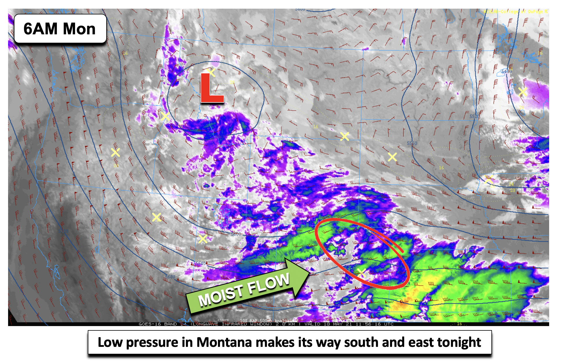
Overcast skies today will keep temperatures from budging too much on Monday or Tuesday. Expect highs in the middle 40’s this afternoon. Tonight, that system in Montana moves to the Utah/Colorado/Wyoming border, with deep lift out ahead of it for the Front Range.
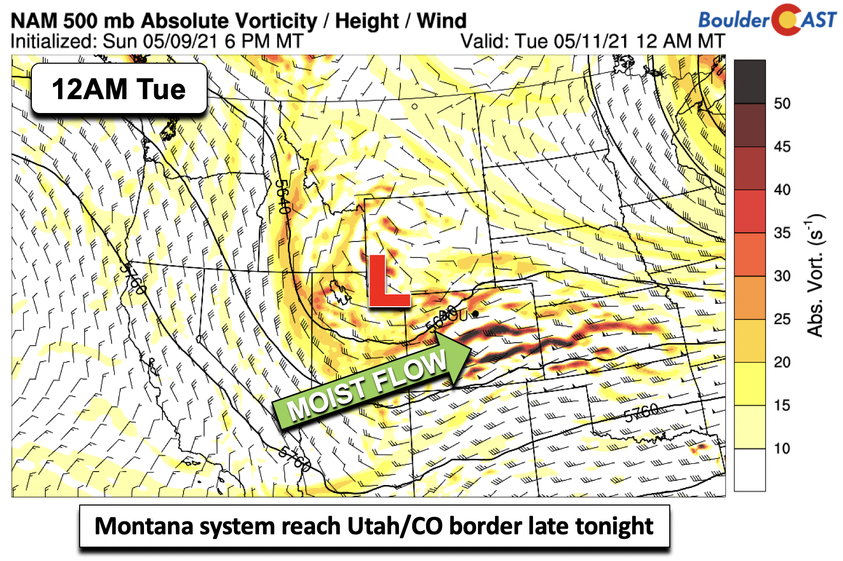
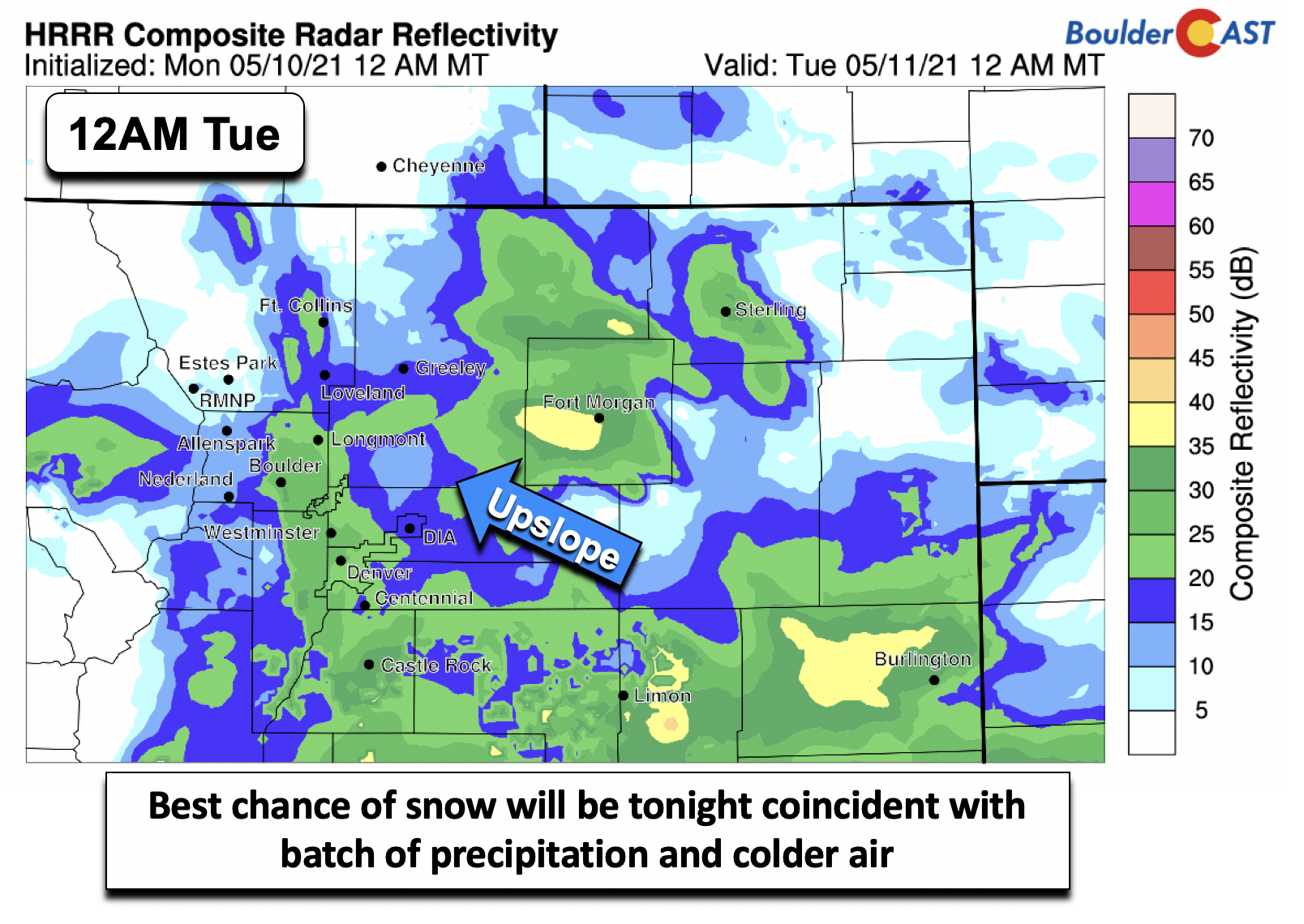
As this lift intensifies tonight, including a nice fetch of Front Range upslope, precipitation will become widespread across the region (below). This is also during the same time when colder air starts to filter down into northeast Colorado.
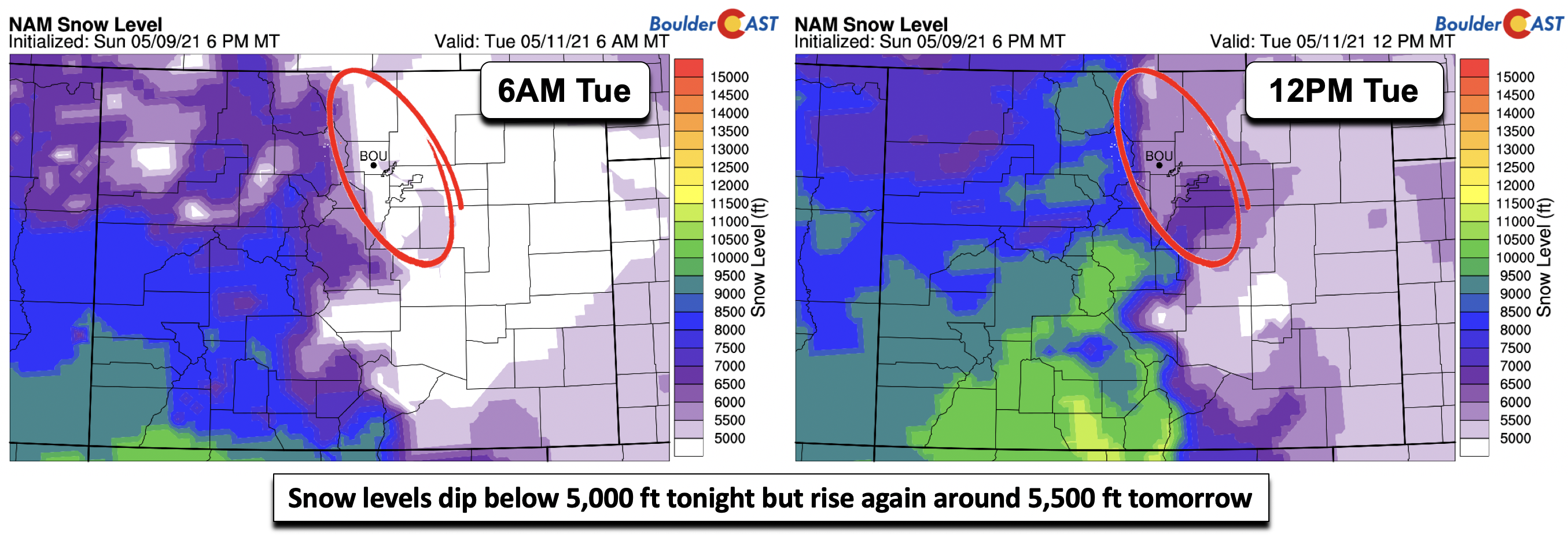
If we take a look at predicted snow levels (in feet), they drop below 5000 feet during the late evening and overnight hours (below left). By tomorrow, with daytime heating and some slight warming in the lower atmopshere, snow levels rise to around 5,500 feet.
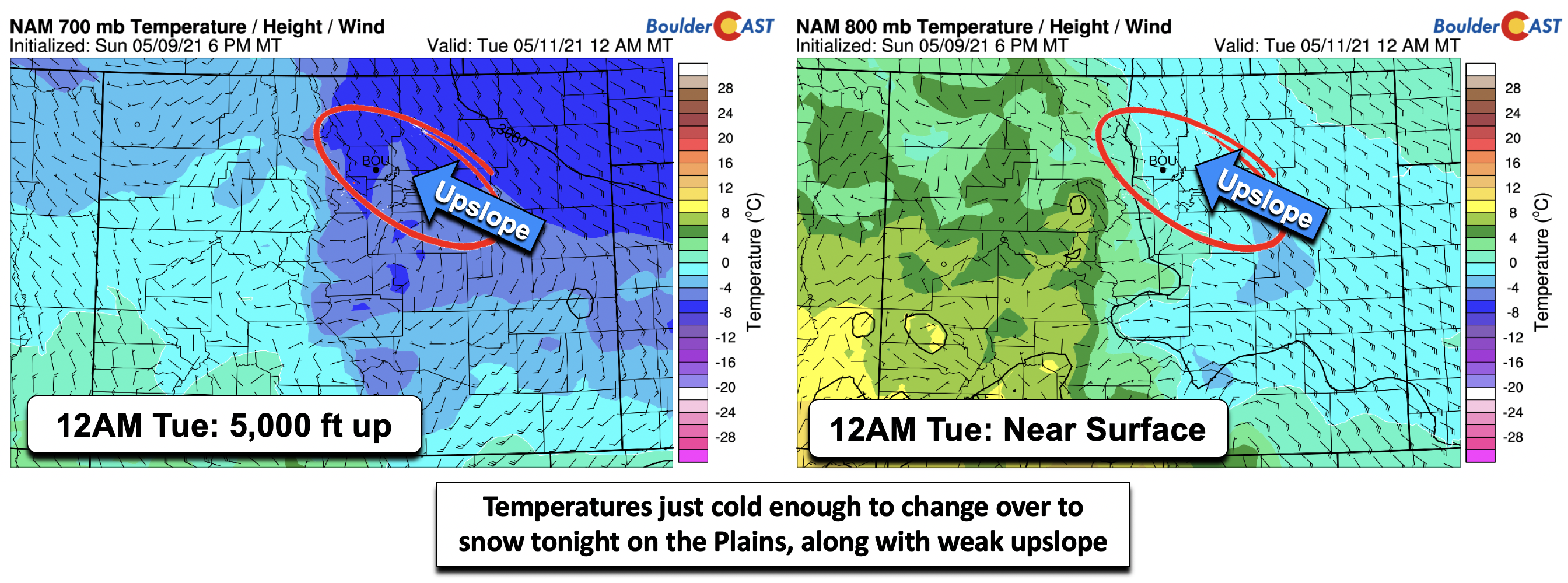
Looking at temperatures roughly 5000 feet up (below left) versus near surface temperatures (below right), you can tell that this is borderline just cold enough for rain to change over to snow on the Plains. The temperature aloft is about -6°C and around -1°C the surface. The GFS (not shown) is colder by about 1-2 °C at both levels, likely too cold given the time of year.
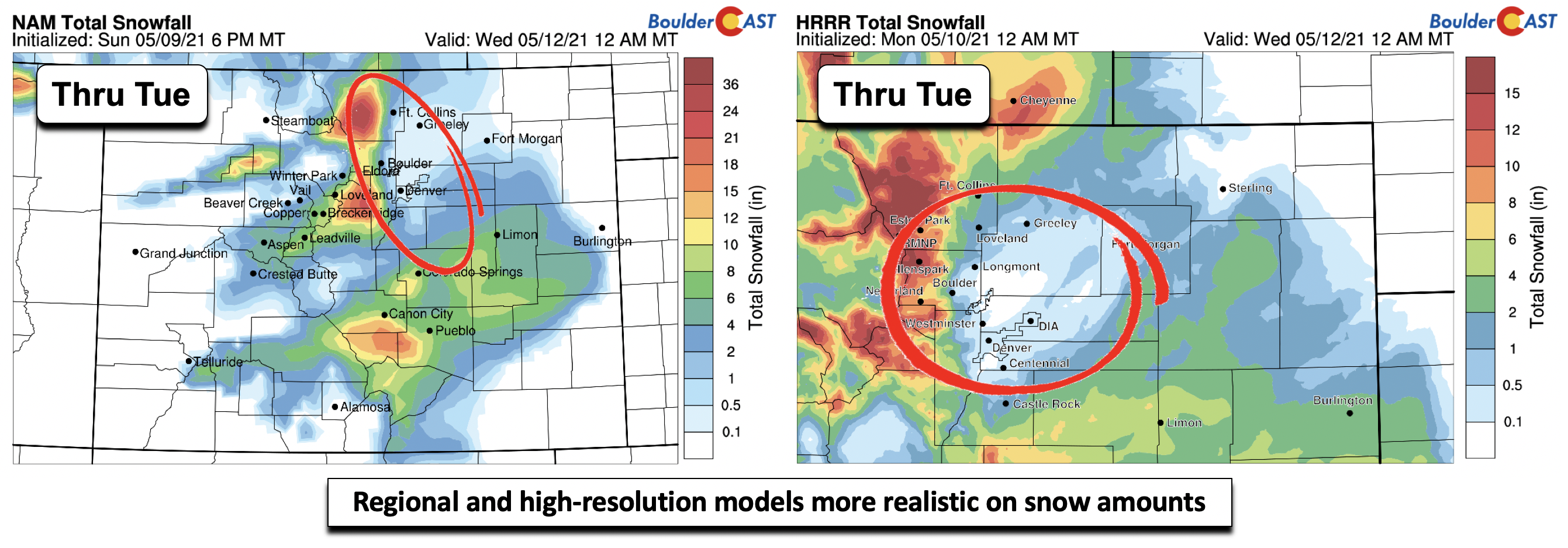
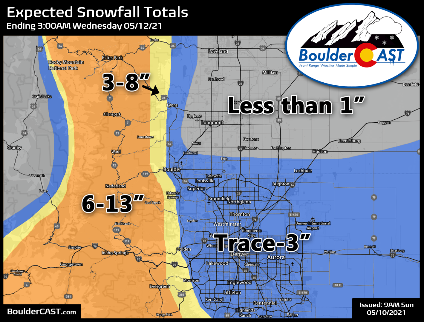
We therefore think the best chance of any accumulating snow will be late tonight to early Tuesday morning, coincident with the deep-lift and colder air in the lower levels of the atmosphere, along with loss of the sun – which is very important in mid-May! If we take a look at the various model predictions for snow totals, we notice a large spread in predicted amounts. The global and ensemble data point to possibly 5+” of snow on the Plains. These are likely too high given the warm ground, time of year, and these models inability to capture the fine-scale details. If we look at the higher resolution models (NAM left left; HRRR below right), we see their amounts are much less, between a trace to 3″ in the NAM and HRRR, respectively. While maybe not fully correct, we think these models are closer to the truth in this mid-May scenario. There is good agreement that most of the Front Range will see about 1″ of precipitation. We feel that most of that will fall as rain or a rain/snow mix.
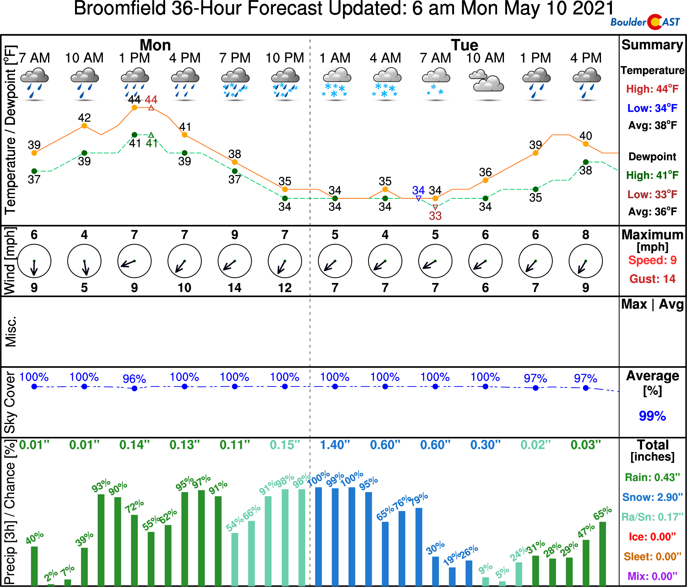
Our forecast calls for about a trace to 3″ on the Plains, with the highest amounts most likely in far southern Denver and around Boulder. Our latest NowCAST shows potential of up to 3″ in Broomfield (below) during the overnight hours tonight, before changing back over to rain/snow tomorrow. This amount is likely a little high considering temperatures may not actually reach freezing overnight. As for the Foothills, colder air and higher elevation would favor 3-12″ in these areas, highest amounts above 8000 feet elevation.
In summary:
- Rain showers develop through the day Monday across the area, mixing with some snow at times this evening. All snow in the Foothills above 7500 feet.
- A changeover to all snow for portions of the Denver Metro tonight to early Tuesday
- Snow mixes back with rain Tuesday morning and eventually changes over to all rain again before ending Tuesday evening
- Amounts: Trace to 3″ on the Plains and 3-12″ in the Foothills (depending on elevation)
- Highs only in the middle 40’s Monday and in the lower 40’s on Tuesday
Our snowfall forecast map for the event is shown below. This covers snow falling all the way into Tuesday night. While snow will be mixing back to rain and winding down across the lower elevations on Tuesday, we may see a resurgence in instability snow showers developing across the higher terrain which could cap things off with several inches of additional accumulation in the Foothills.
There are three impacts to consider from this event:
- Near-freezing temperatures: Temperatures will drop close to freezing across the Plains. Take precautions for any outdoor plants you wish to save. Most likely we will stay a degree or two above freezing as most models are showing, but better safe than sorry!
- Slushy roadways: We’re not expecting any real travel impacts other than wet roadways across the lower elevations Monday night into early Tuesday, but if you’re traveling in the Foothills or through the Palmer Divide, definitely plan on slushy and slick travel. Areas in the Foothills above 8000 feet may get snow-packed Monday night.
- Minor tree damage: Right now we’re not expecting major tree damage in the Denver Metro from potential overnight accumulation. Even with advanced foliage, 1-3″ won’t cause widespread damage. Any more than that, however, and things will get ugly fast!
Warming up toward the latter part of the week
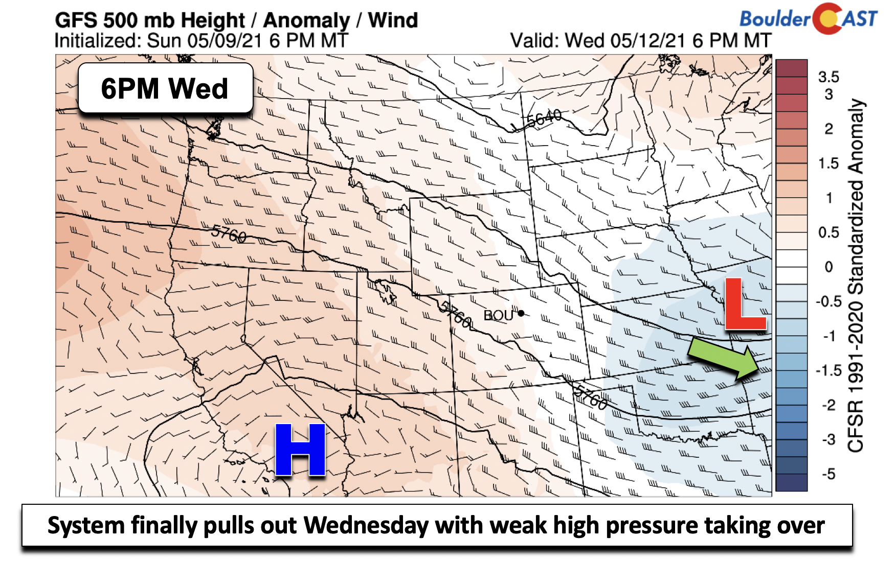
The low pressure system finally pushes out early Wednesday, making its way eastward into the Mississippi River Valley. Weak high pressure to our southwest aids in downslope warming for the Denver area. High temperatures under mostly skies should warm us into the upper 50’s. There might be just enough lingering moisture for a few spotty rain showers in the late-day period. If so, these would mainly be confined to areas in and near the Foothills.
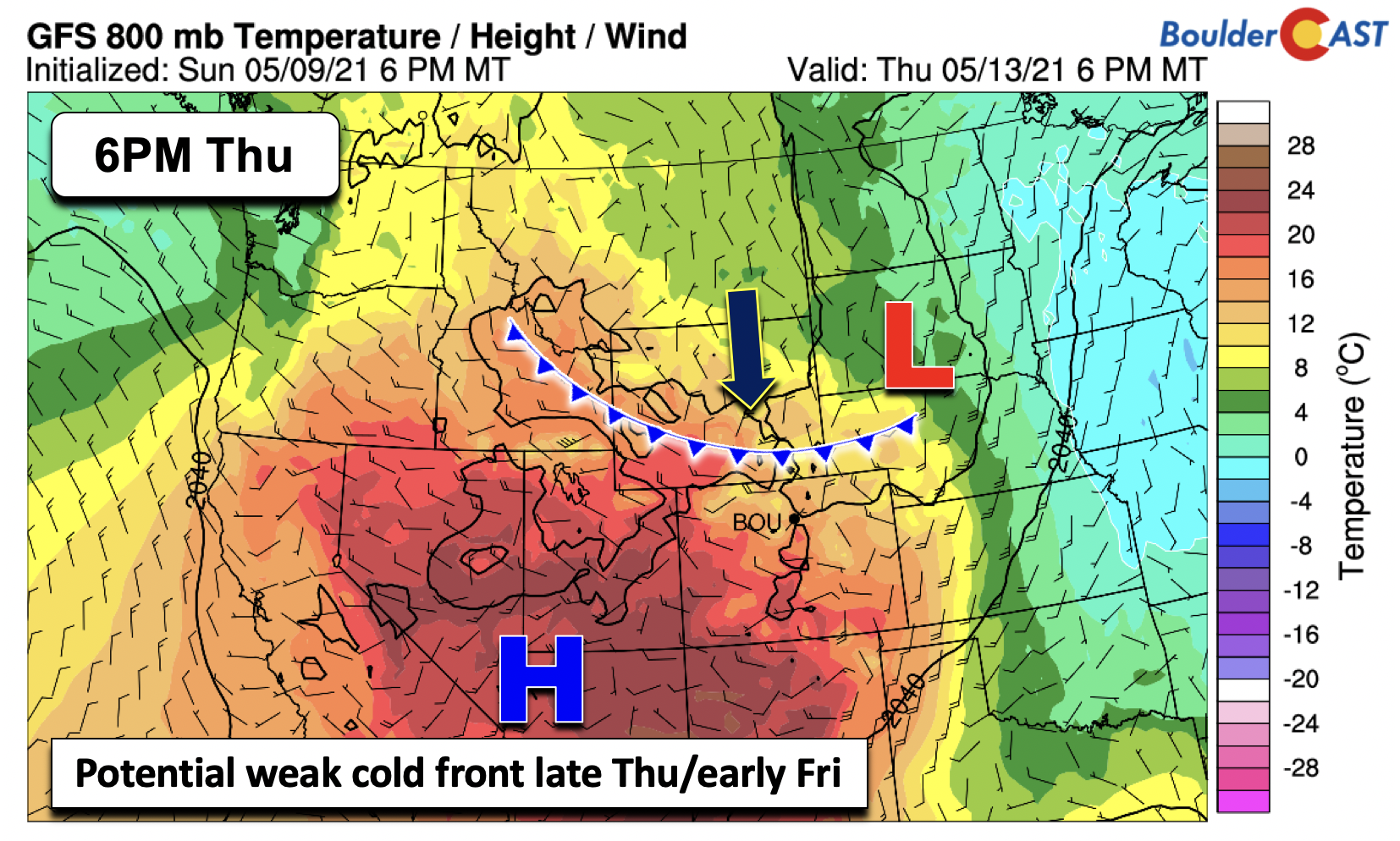
On Thursday, we continue the warm-up, with highs likely returning closer to normal in the lower 70’s. We are watching the potential for a weak cold front to slide down in the northwest flow at the mid-levels. The front may lead to some isolated thundershowers on Thursday but that would be about it.
As we end the week, another trough develops across the eastern Pacific. Our region will still be under high pressure, but the frontal boundary, if it does push through, should keep temperatures in the upper 60’s to lower 70’s. The trough out west may send ripples of energy through the state on Friday. Enough instability could favor some isolated storms again Friday afternoon/evening, but confidence is low on this at the moment. Overall, a much better end to the week compared to the start of it!
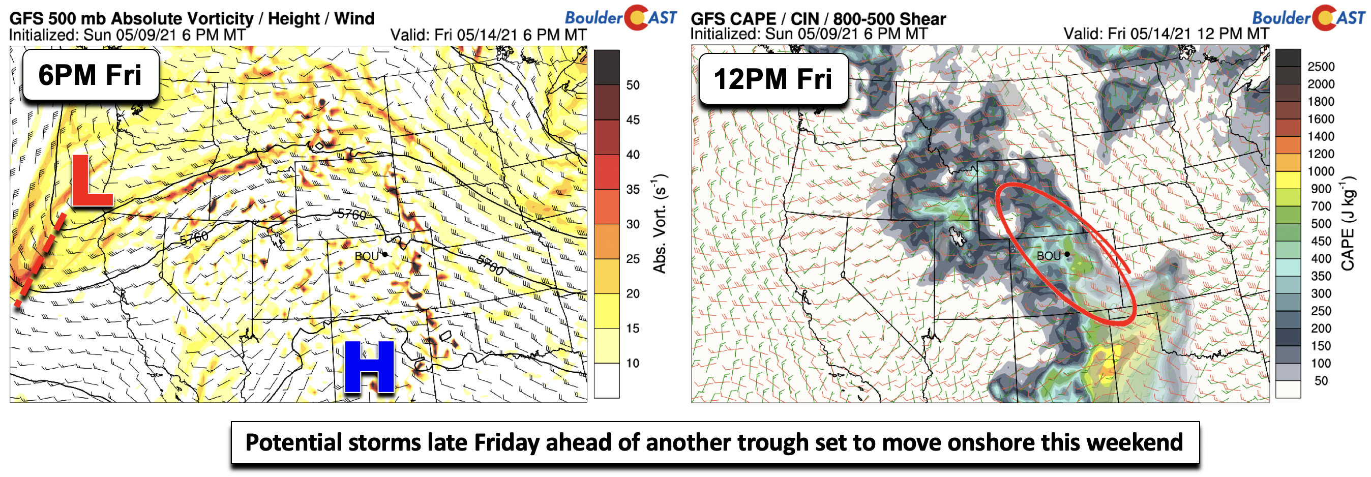
This low pressure on Friday will move onshore by the weekend, leading to a potential unsettled pattern late Saturday and come Sunday. Time will tell.
Stay up to date with Colorado weather and get notified of our latest forecasts and storm updates:
We respect your privacy. You can unsubscribe at any time.
.
Forecast Specifics:
Monday: Overcast skies with spotty rain showers through the day. Rain becomes widespread in the afternoon and evening. Highs in the middle 40’s for the Plains and middle 30’s in the Foothills. Rain mixes with snow or changes fully to snow tonight, with up to 3″ possible in Boulder and 6-13″ in the highest Foothills.
Tuesday: Morning snow to become a mix of rain/snow and then all rain for the afternoon. Snow showers will continue in the Foothills with additional light daytime accumulations possible. Highs remaining cold in the lower 40’s on the Plains and lower 30’s in the Foothills.
Wednesday: Warmer with more sunshine. Still there will be a chance of showers in the afternoon and evening. Highs in the upper 50’s on the Plains and middle 40’s in the Foothills.
Thursday: Partly cloudy skies and closer to normal with highs near 70 degrees for the Plains and upper 50’s in the Foothills. A slight chance of isolated thundershowers in the early evening.
Friday: A mix of clouds and sunshine with isolated showers/storms and temperatures upper 60’s to middle 70’s for the Plains and upper 50’s in the Foothills.
Mountains: Widespread snow across the higher terrain today through Tuesday, with amounts of 3-7″ today and 2-5″ tomorrow. Drier weather takes over Wednesday. Some afternoon and early evening showers or storms are possible to end the week Thursday and Friday.
Help support our team of Front Range weather bloggers by joining BoulderCAST Premium. We talk Boulder and Denver weather every single day. Sign up now to get access to our daily forecast discussions each morning, complete six-day skiing and hiking forecasts powered by machine learning, first-class access to all our Colorado-centric high-resolution weather graphics, bonus storm updates and much more! Or not, we just appreciate your readership!
.
Spread the word, share the BoulderCAST forecast!
.


You must be logged in to post a comment.