Colorado’s weather this week promises to be a mixbag, kicking off with near-record warmth and high fire danger on Monday, followed by a dramatic cool-down with a chance of rain and snow heading into midweek. As we officially transition into the spring season, be prepared for gusty winds, fluctuating temperatures, but only minor precipitation—with an active yet relatively dry forecast for the Denver-Boulder area this week. Read on for all the details.
This week’s highlights include:
- Fire Danger Monday: Near-record warmth in the lower 70s will combine with strong downslope winds and dry air for create high fire danger on Monday
- Turning Cooler Tuesday and Beyond: More seasonal to below average temperatures are expected for the remainder of the week
- Rain/Snow Chance Late Tuesday: A strong passing low pressure system will bring a chance of rain/snow late Tuesday into Tuesday night — but little to no accumulation is expected. Gusty winds over 35 MPH are the bigger story.
- Staying Active Heading into Spring: Precipitation (mostly snow) chances are possible Wednesday and Friday, but those chances appear minimal thus far. The late-week will be season to cooler than normal with occasionally gusty winds.

DISCLAIMER: This weekly outlook forecast is created Monday morning and covers the entire upcoming week. Accuracy will decrease as the week progresses as this post is NOT updated. To receive daily updated forecasts from our team, among many other perks, subscribe to BoulderCAST Premium.

Go Premium, get all the perks.
Daily Forecast Updates
Get our daily forecast discussion every morning delivered to your inbox.
All Our Model Data
Access to all our Colorado-centric high-resolution weather model graphics. Seriously — every one!
Ski & Hiking Forecasts
6-day forecasts for all the Colorado ski resorts, plus more than 120 hiking trails, including every 14er.
Smoke Forecasts
Wildfire smoke concentration predictions up to 72 hours into the future.
Exclusive Content
Weekend outlooks every Thursday, bonus storm updates, historical data and much more!
No Advertisements
Enjoy ad-free viewing on the entire site.
High fire danger & near-record warmth Monday
Our week starts off very warm on Monday as a ridge of high pressure remains centered over New Mexico and stretches as far north as Wyoming. High temperatures Monday afternoon will reach the lower to mid 70s across the lower elevations.
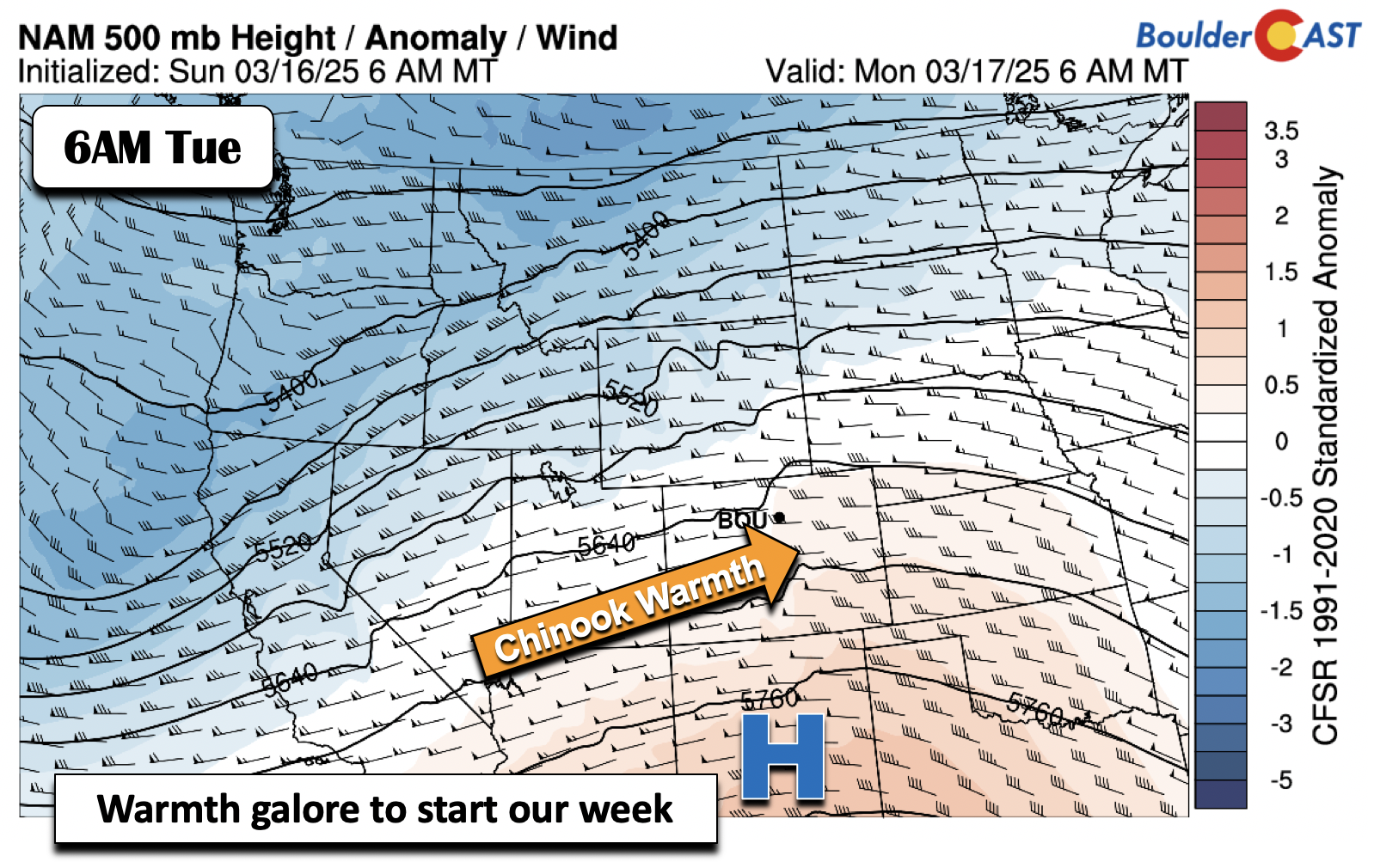
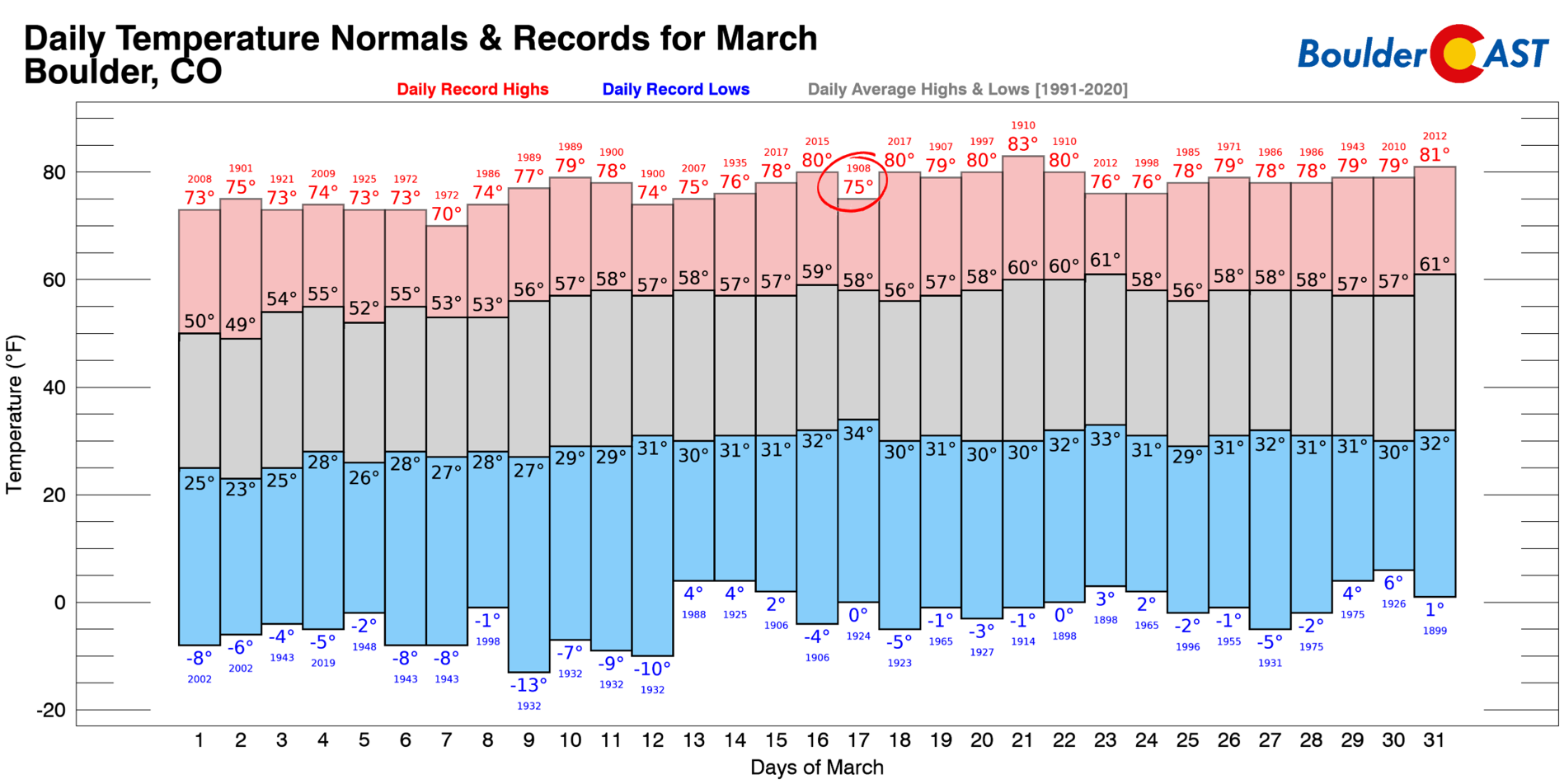
This extreme warmth will put is in the ballpark of existing record highs for Saint Patty’s Day — for Boulder that’s 75°F set back in 1908. We probably will land a tad cooler than this record value, but it’s not impossible we get there. Denver’s record high is 76°F.
Along with the near-record warmth, downslope winds will be blasting on Monday, particularly in the morning when a favorable mountain wave setup will exist. Expect a few gusts up to 55 MPH in the morning in Boulder, with winds of 20 to 40 MPH more common through the rest of the day, strongest west of Interstate 25. These winds, combined with the dry downslope airmass will lead to high fire danger region-wide on Monday.
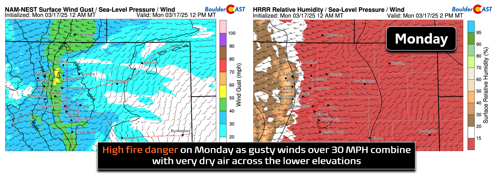
Red Flag Warnings are posted everywhere below 6000 feet elevation where humidities will be under 15% all of Monday.
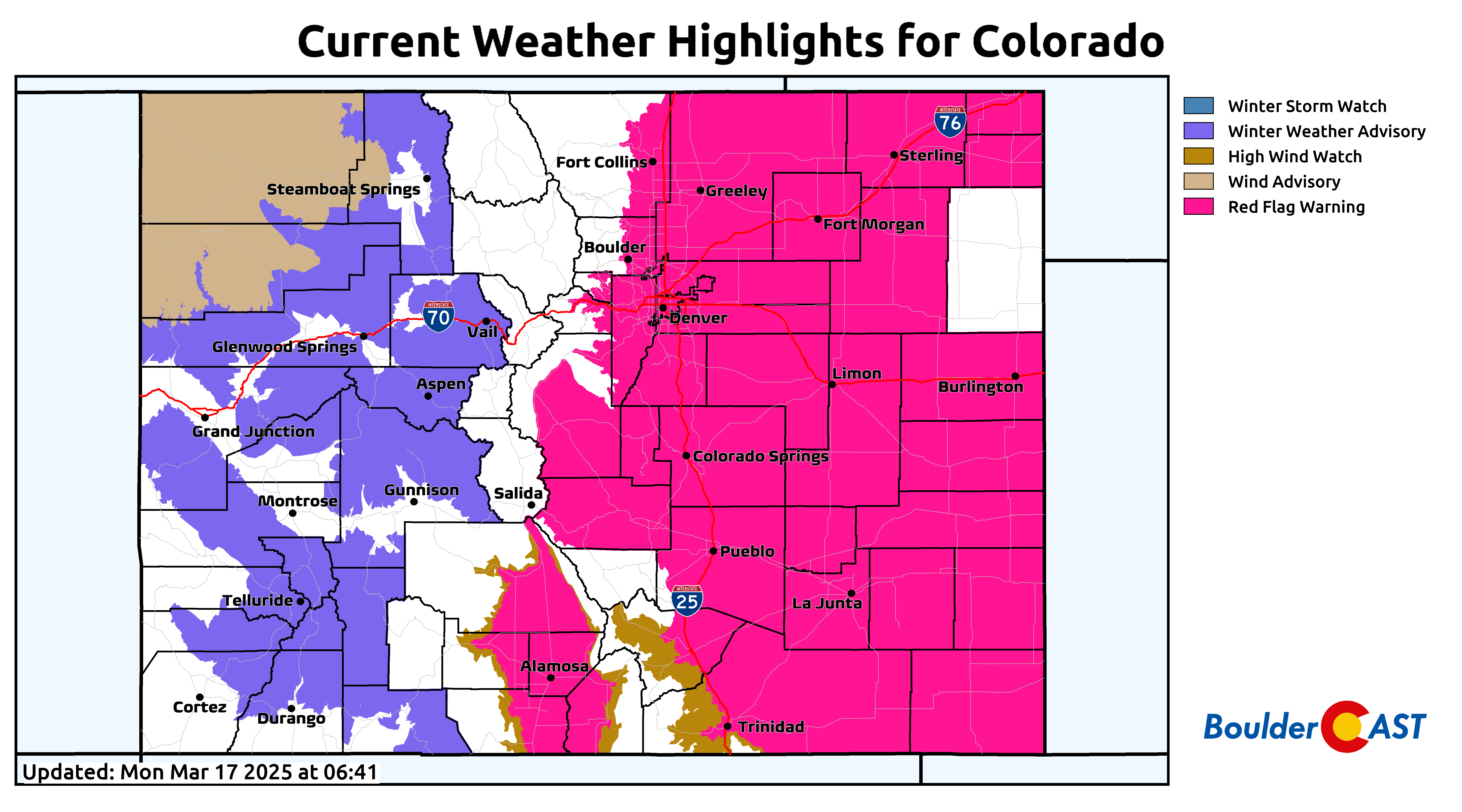
Definitely use caution in this situation — please no green fireworks for the occasion!
![]()
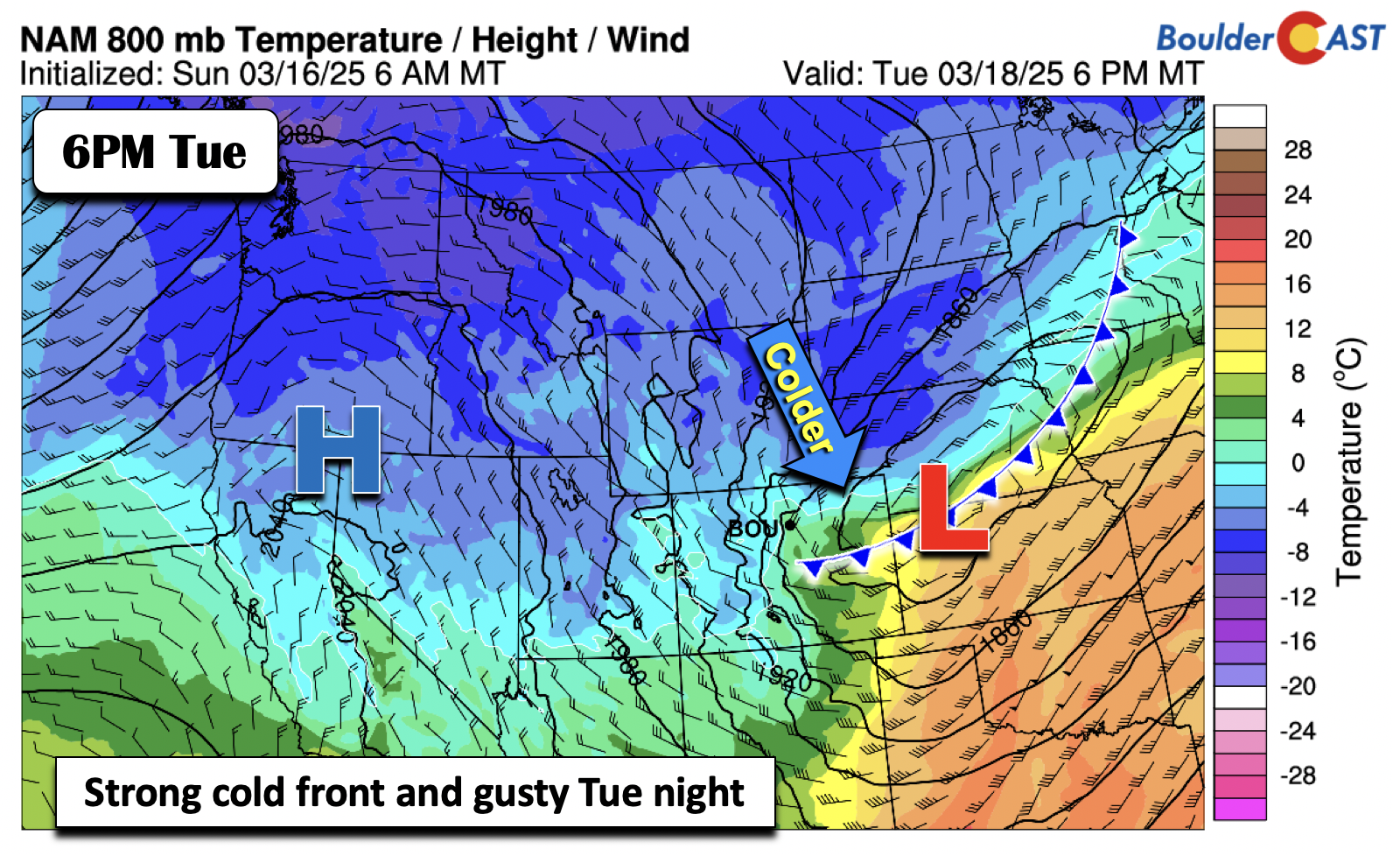
Windy rain/snow mix late Tuesday
On Tuesday, we’ll initially stay warm ahead of a cold front slated to come in during the late afternoon or early evening hours. Before that happens, highs in the lower 60s are expected. Latest guidance has the cold front moving through late in the day on Tuesday, roughly between 2 and 5PM local time. As the front passes, temperatures will drop into the 30s and eventually the 20s by Wednesday morning — quite a change from earlier in the week! Additionally, gusts from the north and northwest will reach speeds of 30 to 45 MPH Tuesday night, with some brief gusts to 50 MPH possible over eastern portions of Denver as a surface low deepens in eastern Colorado.
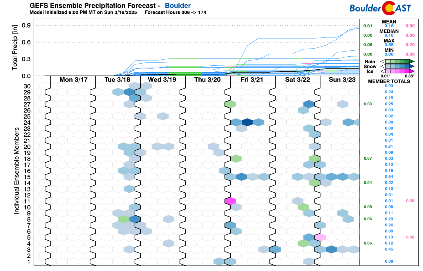
As the low pressure system tied to the front moves east, wrap-around moisture will bring a brief shot of light rain changing to light snow Tuesday evening into early Wednesday. Our flow will primarily be downslope in nature in our immediate area, so only limited impacts are expected.
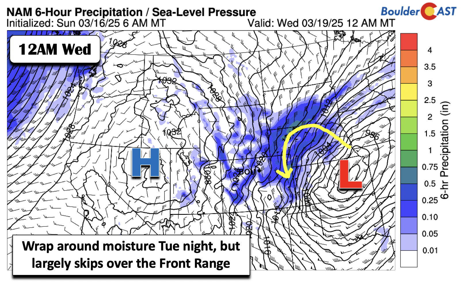
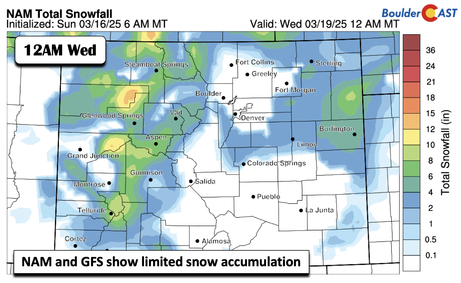
The NAM and GFS models are very much in agreement for a “donut hole” around the Front Range with little to no snow accumulation. Overall, we could see a trace to an inch of snow across the Boulder-Denver area Tuesday night, but some of us may not see any snow at all. The better chance for a few inches of snow will be over eastern Colorado in closer proximity to the surface low (i.e. Limon eastward towards Kansas).
The GEFS ensemble suite is hinting at another weak chance of snow on Wednesday afternoon and another perhaps on early Friday. We’ll discuss these next.
A few minor precipitation chances the rest of the week
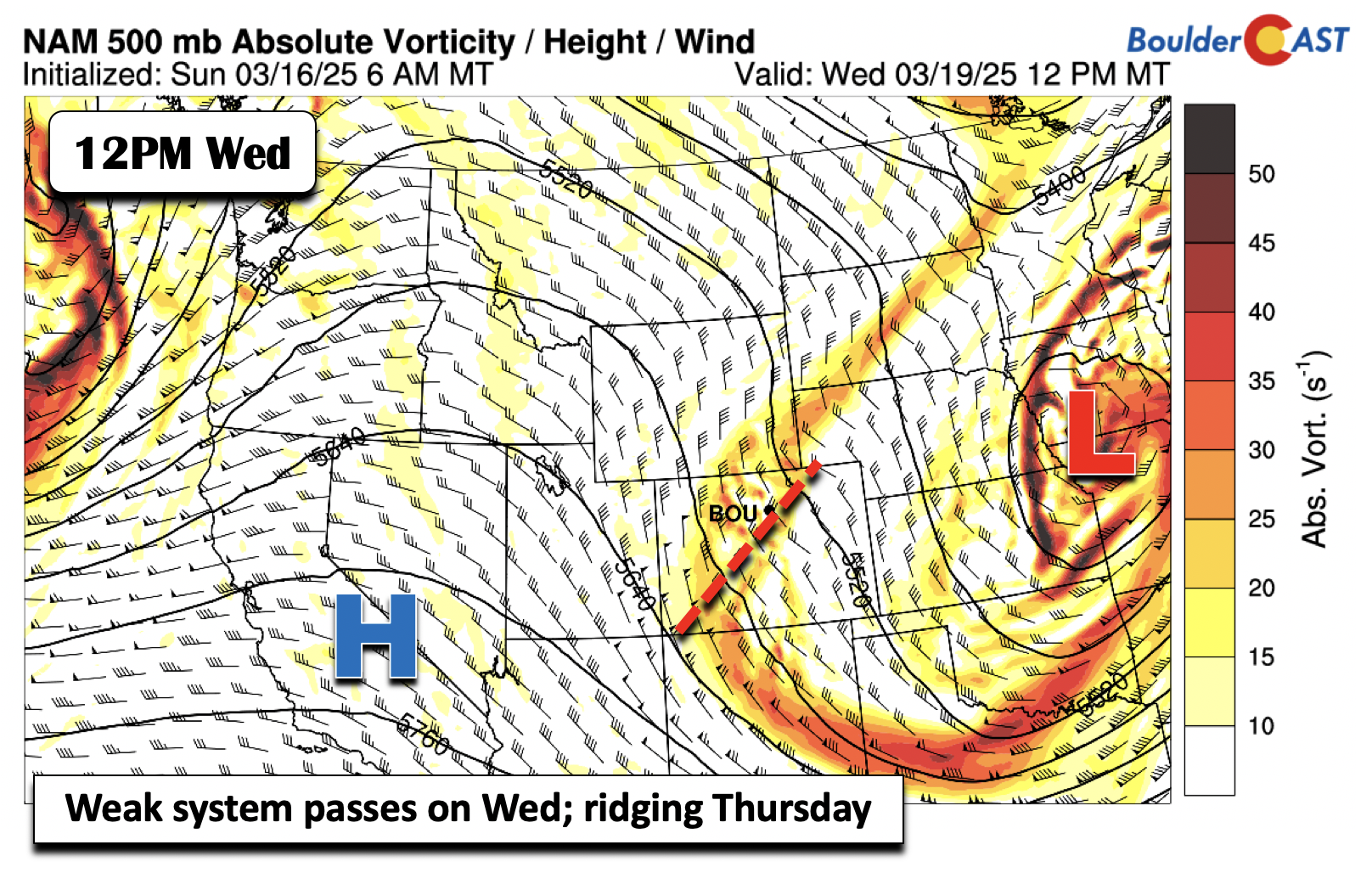
As the trough and system from Tuesday lift eastward into the Midwest, ridging will build east with time. A passing trough axis and weak shortwave will move overhead Wednesday midday. Most of this shortwave will bring just light snow showers for the higher terrain west of the Divide. However, a few light snow showers could reach the Denver Metro but largely not resulting in anything measurable. Wednesday should be mostly dry, but we will include a slight chance (less than 10%) of a snow shower in the forecast. Breezes of 15 to 25 MPH will also be around midweek for us.
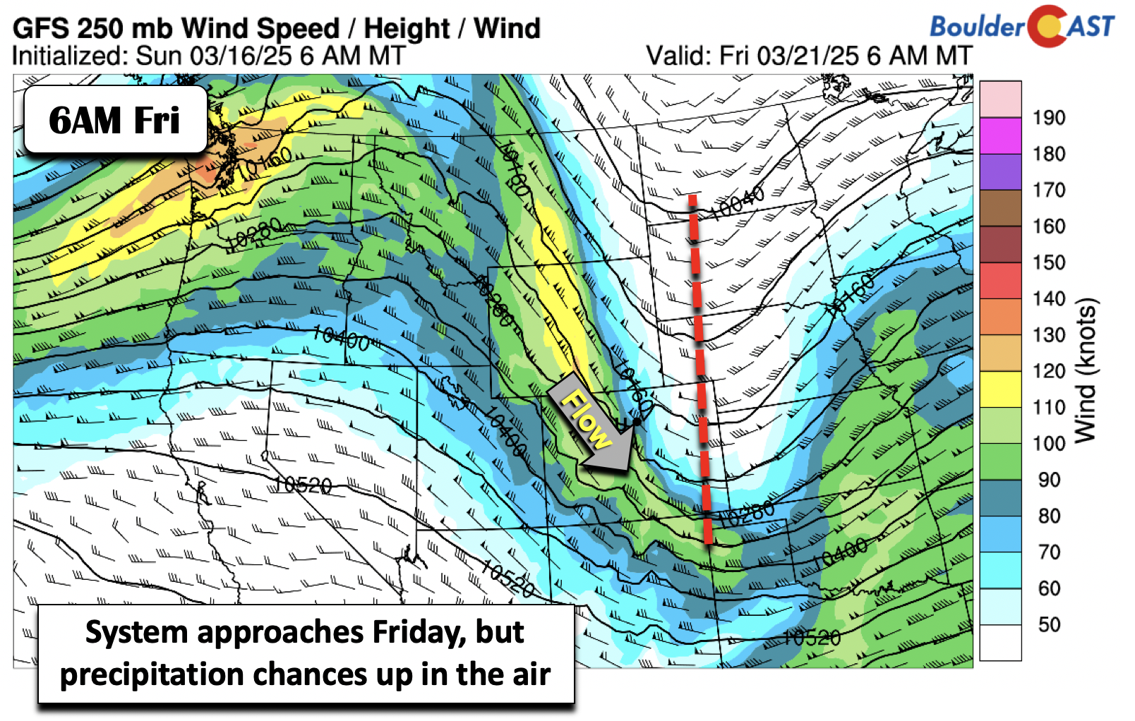
After only topping out in the 40s on Wednesday, ridging will return and spell out quiet conditions and warmer temperatures in the 50s to near the lower 60s by Thursday. Another late-week system moves overhead with a more impressive trough than Wednesday. However, models are largely showing that it moves across with downslope flow into the Boulder-Denver area. The ECMWF does indicate a more southward track, which could warrant a light snow chance as it passes early in the day. For the time being, we think it is worth watching but does not appear impactful at this stage.
As we’ve discussed above, the week ahead will be active but not overly rainy or snowy in the Denver Metro area. The pesky wind and fluctuating temperatures will be the bigger stories this week.
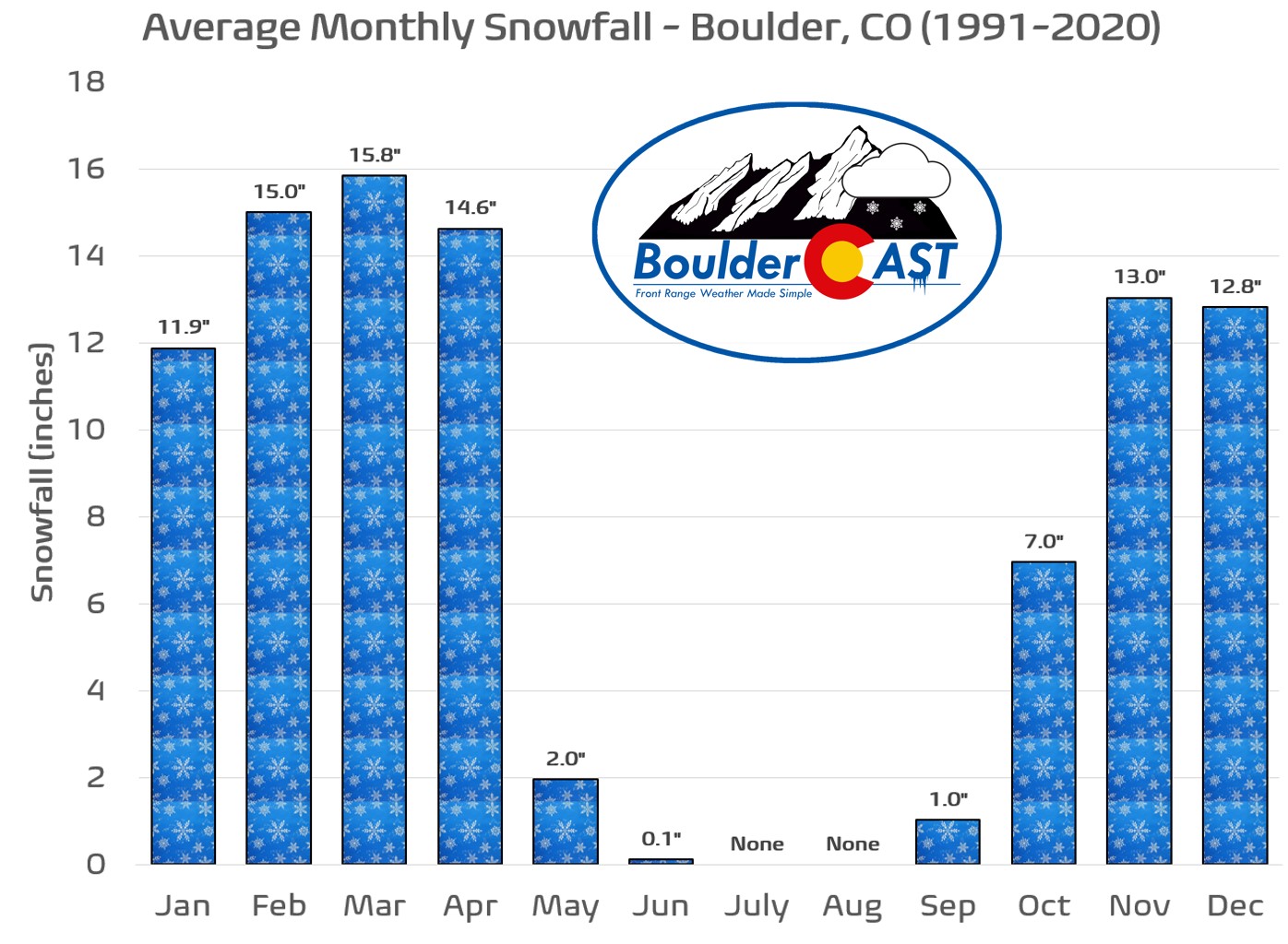
A reminder that Thursday is the first day of spring. That’s only in name of course here in Colorado — we’ve still got plenty of snow to go in the coming two months. Enjoy!
Forecast Specifics:
Monday: Partly to mostly sunny with near-record warmth and HIGH fire danger. Highs in the low to mid 70s on the Plains and lower to mid 60s in the Foothills. Westerly winds gusting 20 to 40 MPH during the day, even stronger in the morning hours around Boulder.
Tuesday: Warm to start, then colder and blustery in the evening. Highs in the lower 60s on the Plains and 50s in the Foothills. Turning colder into the 20s overnight. A chance of light rain changing to snow in the evening but only minimal accumulations are expected (less than 1″).
Wednesday: Breezy, colder and below normal temperatures with mid 40s in the Denver Metro and mid 30s in the Foothills. There is a slight chance of a late-day snow shower or flurry, mainly in the higher terrain.
Thursday: Milder and quiet with highs in the upper 50s on the Plains and upper 40s in the Foothills.
Friday: A slight chance of light snow early in the day, then mostly sunny. Otherwise seasonal with highs around 50 degrees on the Plains and low 40s in the Foothills.
Get BoulderCAST updates delivered to your inbox:
DISCLAIMER: This weekly outlook forecast is created Monday morning and covers the entire upcoming week. Accuracy will decrease as the week progresses as this post is NOT updated. To receive daily updated forecasts from our team, among many other perks, subscribe to BoulderCAST Premium.
Go Premium, get all the perks.
Daily Forecast Updates
Get our daily forecast discussion every morning delivered to your inbox.
All Our Model Data
Access to all our Colorado-centric high-resolution weather model graphics. Seriously — every one!
Ski & Hiking Forecasts
6-day forecasts for all the Colorado ski resorts, plus more than 120 hiking trails, including every 14er.
Smoke Forecasts
Wildfire smoke concentration predictions up to 72 hours into the future.
Exclusive Content
Weekend outlooks every Thursday, bonus storm updates, historical data and much more!
No Advertisements
Enjoy ad-free viewing on the entire site.
Enjoy our content? Give it a share!


You must be logged in to post a comment.