
Following the long, cold and gloomy holiday weekend, our weather improves considerably in the coming days. Temperatures will warm back above average and may even approach 90 degrees for the first time in 2021. After a few dry days, subtropical moisture is expected to surge into Colorado during the upcoming weekend bringing the return of wet weather to the region.
This week’s highlights include:
- Much nicer weather this week than we had over the holiday weekend
- Widely scattered thunderstorms Tuesday with a passing shortwave dropping out of Wyoming, some could be severe
- Dry weather returns Wednesday through Friday as temperatures climb well into the 80’s
- Subtropical moisture invades Colorado during the upcoming weekend with storms returning

DISCLAIMER: This weekly outlook forecast is created Monday morning and covers the entire upcoming week. Accuracy will decrease as the week progresses as this post is NOT updated. To receive daily updated forecasts from our team, subscribe to BoulderCAST Premium.

An end to the gloomy weather!
The sun barely made an appearance over Memorial Day weekend with much of the Front Range seeing persistent gloom alongside the rain. The graphic below shows 72-hour rainfall totals ending at 6AM Tuesday. These are cooperative observations, so they aren’t necessarily that accurate. The largest official total we found was in Boulder where 1.64″ of rain was reported. The official high temperature in Boulder on Memorial Day was just 57°F. This came within a few degrees of the all-time record low maximum for May 31st. While not record-breaking, it was darn cold on Monday!

Not surprisingly, as the long weekend comes to an end, so too does the gloomy weather across the Front Range! The mid-level trough responsible for the low clouds and wet weather has shifted south and east alongside a cut-off low pressure in the Mexican Baja. A large ridge of high pressure exists along the West Coast into the Pacific Northwest. This ridge will be a factor for us later in the week. For Tuesday, however, the focus will be on northwest flow and a weak embedded shortwave dropping south out of Wyoming. This wave will facilitate the chance of scattered showers and thunderstorms on Tuesday.

The HRRR model simulated radar animation below shows the developing storms Tuesday afternoon into early evening and their progression from northwest to southeast. The best chance will be from 1PM to 7PM today.

HRRR model-simulated radar animation for Tuesday showing developing thunderstorms across the Front Range
The Storm Prediction Center includes the eastern portions of the Front Range in the Marginal Risk for severe weather on Tuesday. Both shear and CAPE are fairly limited during the afternoon, so the risk is low and only isolated severe cells are expected, if any. The primary risks are 1″ hail and 60 MPH wind gusts across the eastern Plains of Colorado.

High temperatures on Tuesday will be much warmer than recent times, but still below normal for early June. Look for highs in the upper 60’s to near 70 degrees.

Drying out & warming up
Wednesday and beyond that ridge of high pressure along the West Coast will slide eastward to encompass Colorado as well. This migration is shown in the GFS ensemble 500 mb height forecast animation below. The ridge initially is fairly amplified into Canada early this week. However, by the time it reaches Colorado it will flatten out considerably.

GFS 500mb height anomaly forecast animation spanning from Tuesday into Sunday. The ridge shifts easts and flattens over Colorado.
Nonetheless, the pattern will bring on a warming and drying trend to the Denver Metro area overall. Wednesday through Friday will be largely dry for the lower elevations, with just some afternoon instability firing off isolated to widely scattered storms in the Mountains. A closer inspection of the steering flow with this ridge (below) shows that winds aloft will veer from northerly on Wednesday to northeasterly on Friday. This shift will help to keep any storms that do form from reaching the Boulder and Denver area. Both of these flow patterns favor the storms remaining over the higher terrain.

Temperatures rise slowly each day this week. Wednesday will reach the upper 70’s. Thursday will be in the lower 80’s, pushing perhaps towards the upper 80’s by Friday.
Wet weather returns for the weekend
Models begin to diverge over the upcoming weekend in regards to the timing surrounding a surge of subtropical moisture. The ridge will be weakening with flow turning southwesterly across Colorado. This will ultimately result in more moisture inundating the state. The GFS model, shown below, brings copious moisture into Colorado by Saturday afternoon, whereas the Euro model remains notably drier. If the GFS verifies, Saturday could be fairly wet during the afternoon and evening with thunderstorms. For now, we will mention a chance of storms on Saturday but most of the activity could remain across western Colorado and the Mountains. Sunday will likely be wet as well with late-day storms developing. If the drier Euro solution does come to fruition, Saturday could be our first 90-degree of the year, but you know what they say about counting chickens…

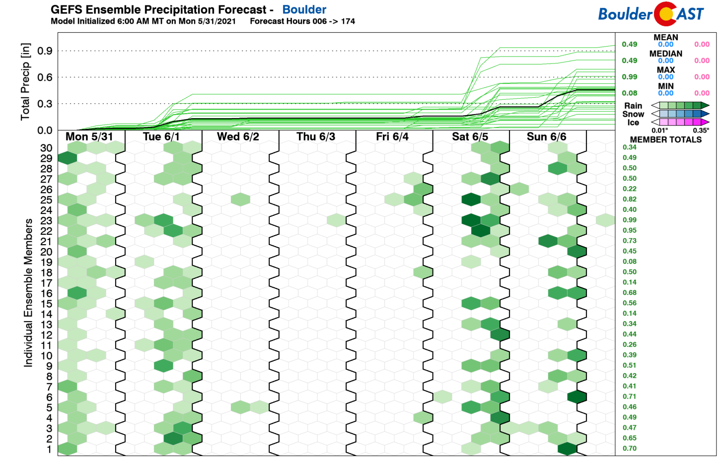
The GFS ensemble precipitation forecast below summarizes the week ahead. Wet weather takes a hiatus Wednesday through Friday, but conveniently returns just in time to make an attempt at spoiling another weekend.
Finally, let us be the first to wish you a happy first day of summer! Of course we are talking about meteorological summer which begins on June 1st and runs through August 31st.
Enjoy the shortened work-week and nicer weather ahead!
Stay up to date with Colorado weather and get notified of our latest forecasts and storm updates:
We respect your privacy. You can unsubscribe at any time.
.
Forecast Specifics:
Tuesday: Morning sun, then increasing clouds with scattered afternoon and early evening thunderstorms. One or two cells could be severe with 1″ hail, mainly east of Denver. Highs near 70 degrees across the Plains with upper 50’s in the Foothills.
Wednesday: A mix of clouds and sun with temperatures seasonal in the upper 70’s across the Plains and lower 60’s in the Foothills.
Thursday: Mostly sunny and dry. Highs in the lower 80’s on the Plains with upper 60’s in the Foothills.
Friday: Sunny and warm with temperatures in the mid to upper 80’s on the Plains and lower 70’s in the Foothills.
Saturday: Morning sun with increasing clouds and widely scattered late-day thunderstorms. Hot with highs in the upper 80’s across the Plains and middle 70’s in the Foothills.
Mountains: The chance of rain and thunder will exist in the Mountains every day this week. The wettest days will be Tuesday and Saturday with scattered to widespread storms. Wednesday through Friday will see isolated storms. Snow levels are near 12,500 feet on Tuesday so snow is possible on the highest peaks. Temperatures warm thereafter with mostly rain expected through the rest of the week, even on the top of the 14ers.
Help support our team of Front Range weather bloggers by joining BoulderCAST Premium. We talk Boulder and Denver weather every single day. Sign up now to get access to our daily forecast discussions each morning, complete six-day skiing and hiking forecasts powered by machine learning, first-class access to all our Colorado-centric high-resolution weather graphics, bonus storm updates and much more! Or not, we just appreciate your readership!
.
Spread the word, share the BoulderCAST forecast!
.


You must be logged in to post a comment.