After a hot and mostly dry Monday, the Front Range is in store for a wetter stretch midweek, with an uptick in monsoonal moisture and storm activity. A favorable upper-air pattern and midweek cold front will drive daily thunderstorm chances and potential flash flooding, especially Tuesday through Thursday. Conditions will trend hotter and drier into the weekend and next week, exacerbating the ongoing drought and fire risk in the High Country.
This week’s highlights include:
- Storm Chances Peak Midweek: Monsoonal moisture will surge Tuesday through Thursday, bringing near-daily storm activity and a heightened risk for heavy rainfall and flash flooding.
- Moisture-Driving Weather Pattern: A trough over the Pacific Northwest and high pressure over the southern Plains will funnel a moist southwest flow into Colorado, enhancing storm formation.
- Flash Flood Setup: Elevated precipitable water values and weak mid-level winds will lead to slow-moving storms capable of producing localized flooding, especially in recent burn scars.
- Temps Shift With the Front: Hot conditions kick off the week, with a cold front arriving midweek that cools temperatures and supports storm development—particularly Wednesday and Thursday.
- Drying Out and Heating Up By the Weekend: Ridging returns late week, steering Colorado toward drier west winds and tapering rain chances. The extended outlook pushes us towards triple-digit heat with limited rainfall — not good for the drought/fire danger brewing in western Colorado or the Mountains.

DISCLAIMER: This weekly outlook forecast is created Monday morning and covers the entire upcoming week. Accuracy will decrease as the week progresses as this post is NOT updated. To receive daily updated forecasts from our team, among many other perks, subscribe to BoulderCAST Premium.

Go Premium, get all the perks.
Daily Forecast Updates
Get our daily forecast discussion every morning delivered to your inbox.
All Our Model Data
Access to all our Colorado-centric high-resolution weather model graphics. Seriously — every one!
Ski & Hiking Forecasts
6-day forecasts for all the Colorado ski resorts, plus more than 120 hiking trails, including every 14er.
Smoke Forecasts
Wildfire smoke concentration predictions up to 72 hours into the future.
Exclusive Content
Weekend outlooks every Thursday, bonus storm updates, historical data and much more!
No Advertisements
Enjoy ad-free viewing on the entire site.
A wetter period in store, centered on the middle of the week
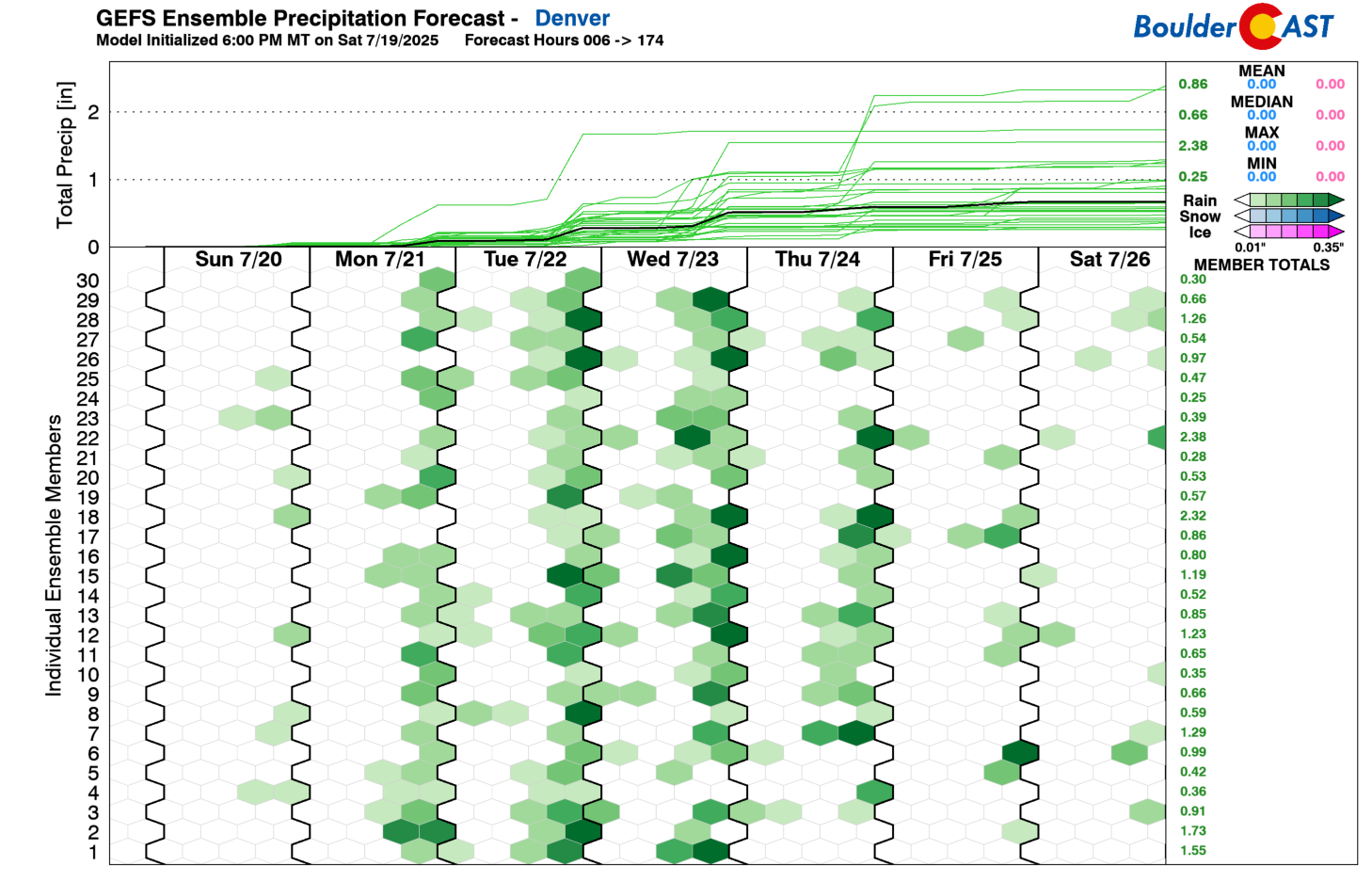
Anoticeable uptick in monsoonal moisture is on the way—especially from Tuesday through Thursday. That’s our prime window for widespread storm activity, with almost daily chances for showers and thunderstorms centered on the midweek stretch. We’ll dig into the broader weather pattern driving these changes, but heads up: heavy rainfall and localized flash flooding are on the table throughout the week. Some ensemble members from the GEFS are even showing QPF totals over 2 inches. While those are on the high end, they do underscore the risk of excessive rainfall.
Two key players in the upper-level pattern are setting the stage:
- A broad trough will settle over the Pacific Northwest early this week, then shift eastward into the northern Great Plains.
- At the same time, high pressure over the southern Plains will help establish a persistent southwest flow into Colorado.
Together, this setup enhances monsoon moisture transport and lead to daily storm development across the region.

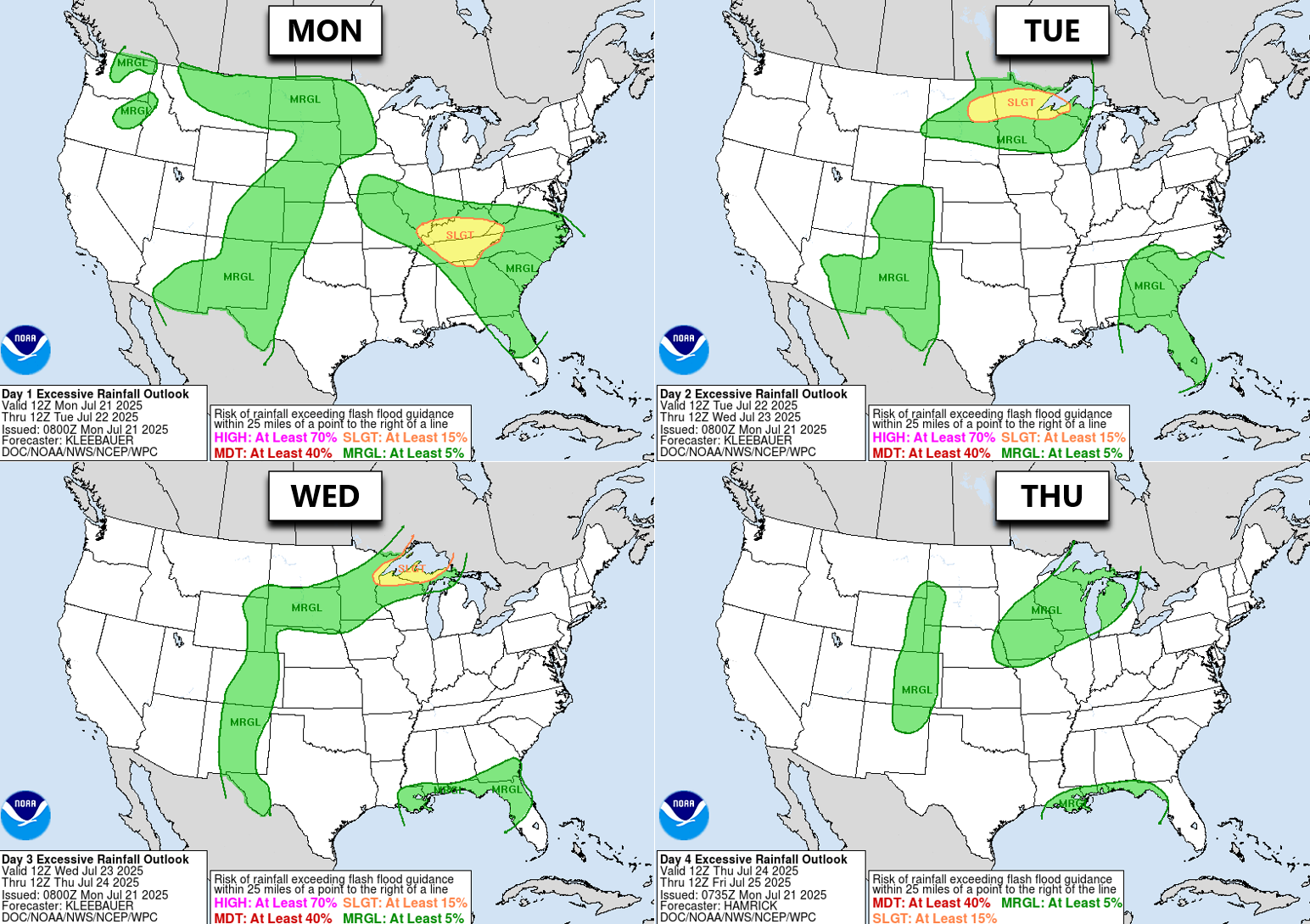
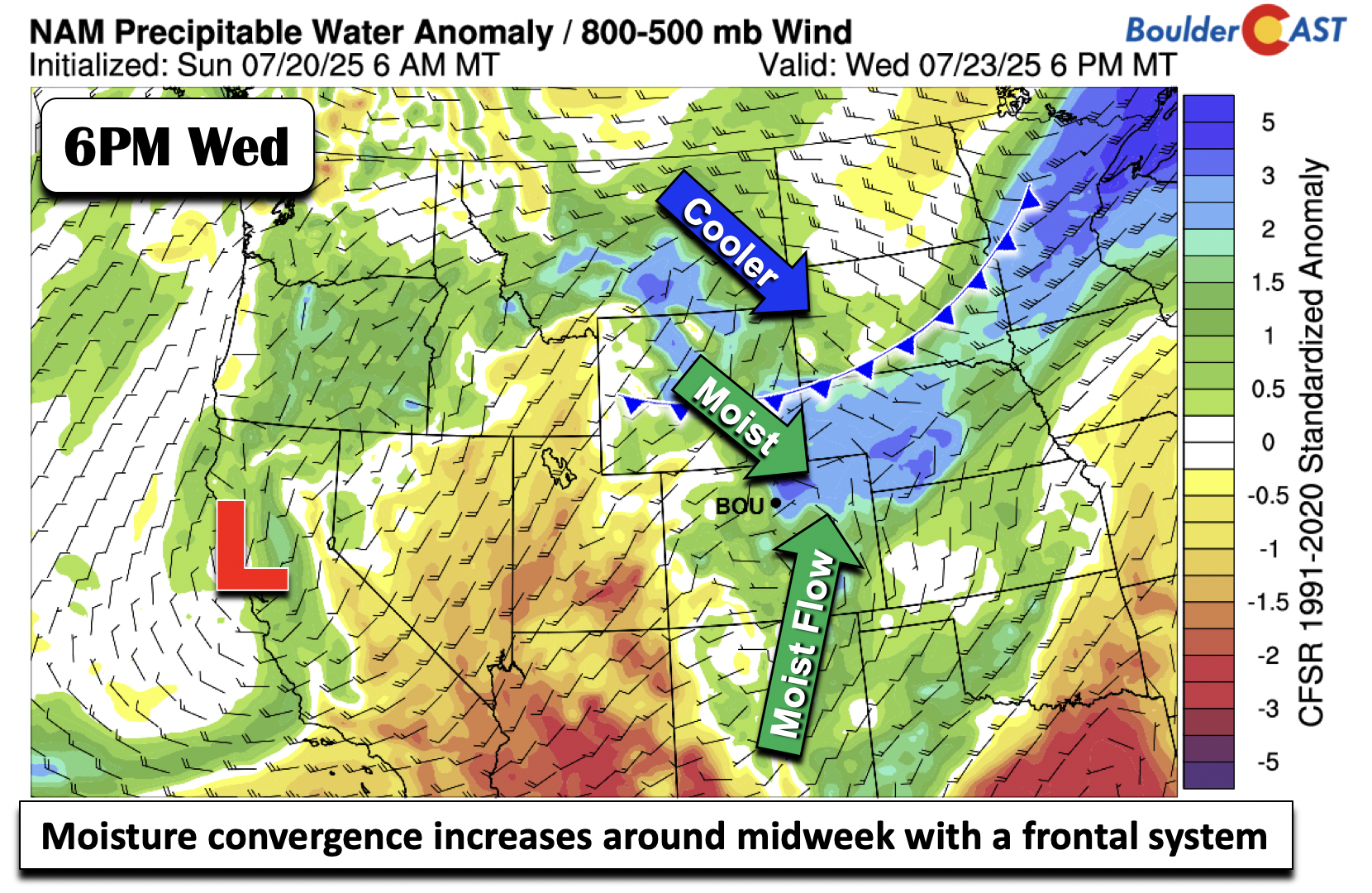
By Tuesday, precipitable water values will climb past 1 inch—well above seasonal norms for late July. Combine that with relatively weak mid-level flow, and you’ve got a recipe for slow-moving storms that can dump serious rainfall. Flash flood potential will tick upward as a result, particularly in areas prone to terrain-enhanced runoff (recent burn scars).

The NOAA Weather Prediction Center currently places much of the Front Range under a Marginal Risk for excessive rainfall nearly every day this week.
We’re also starting the week on a toasty note, with highs in the low to mid 90s through Tuesday.
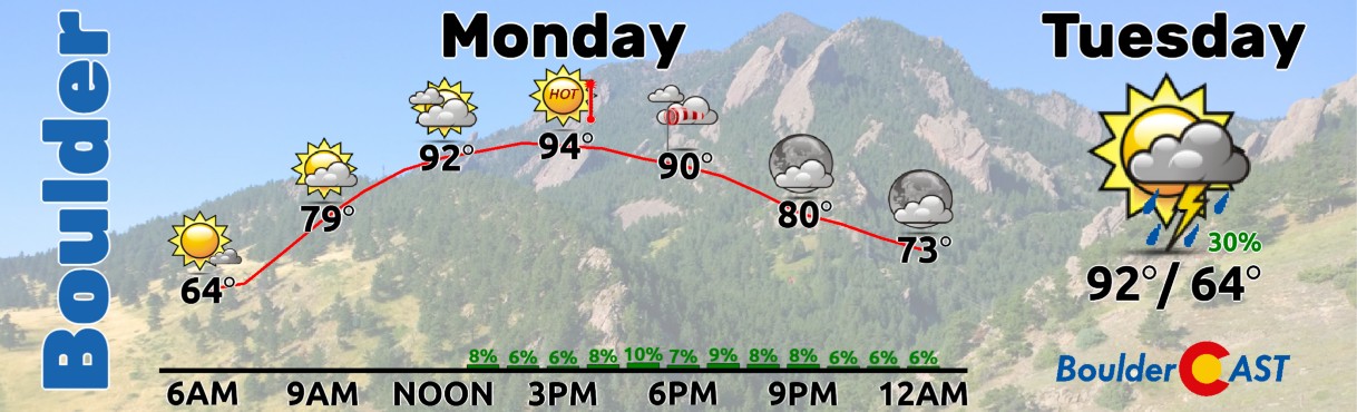
The lower atmosphere is unusually warm and moist for late July, which—paired with minimal rain chances—means plenty of sun to accompany the heat.

By Wednesday, a cold front will be knocking on the door along the Wyoming border, with a pre-frontal trough helping spark low-level convergence over the Front Range. The front should pass through sometime Thursday morning, bringing cooler temps and shifting rain chances downward for Friday. Temps drop back to near average Wednesday through Friday as the frontal system approaches and eventually pushes through.

Notably, this frontal interaction will also enhance deep-layer moisture convergence across the Denver Metro area—likely making Tuesday through Thursday our wettest stretch (30 to 60% rain chances daily). After the front clears, upslope flow Thursday will support lingering showers and storms.
By Friday, ridging starts inching closer from the west. That nudges the upper-level winds toward a drier westerly flow, helping rain chances decrease to end the week. Temperatures return to the lower 90s by Friday as well.
The latest GFS outlook shows some areas potentially picking up around 1 inch of rainfall by week’s end—though isolated pockets could see totals above 2 inches, depending on storm placement.

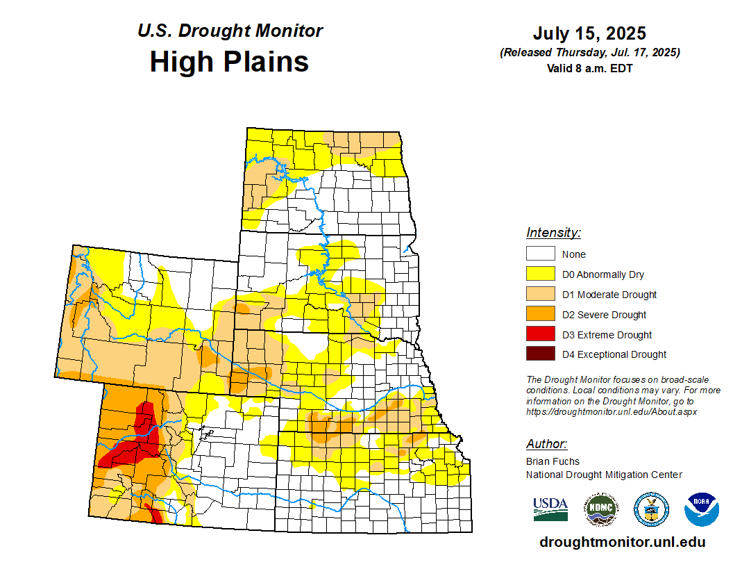
Drought conditions are tightening their grip across the Mountains and Western Slope, with some areas growing dangerously dry. This week’s scattered showers may offer a brief reprieve—especially for parts of the Mountains —but relief will be hit-or-miss, and the hardest-hit regions could be left waiting.
Looking ahead, a hot and dry pattern is expected to settle in by the weekend and stick around into next week. Temperatures along the Front Range are forecast to climb back toward 100°F, and any lingering moisture will likely vanish, worsening drought stress and fire danger across the High Country.
Forecast Specifics:
Monday: Partly cloudy with isolated late-day storms coming off the terrain — more wind than rain with these. Highs hot in the low to middle 90s for the Plains with lower 80s in the Foothills.
Tuesday: Hot with scattered to numerous afternoon and evening storms. Highs in the low to middle 90s on the Plains with lower 80s in the Foothills.
Wednesday: Cooler and more seasonal with numerous late-day showers and storms, potentially focused more on the evening than afternoon. Heavy rainfall could cause flash flooding. Highs in the mid to upper 80s in the Denver Metro and upper 70s in the Foothills.
Thursday: Staying cooler in the middle 80s with late-day storms likely. Storms could produce localized flash flooding. The Foothills only reach into the 70s.
Friday: Starting to dry out. Morning sun gives way to only a few storms. Highs return to the lower 90s on the Plains with upper 70s in the Foothills.
DISCLAIMER: This weekly outlook forecast is created Monday morning and covers the entire upcoming week. Accuracy will decrease as the week progresses as this post is NOT updated. To receive daily updated forecasts from our team, among many other perks, subscribe to BoulderCAST Premium.
Go Premium, get all the perks.
Daily Forecast Updates
Get our daily forecast discussion every morning delivered to your inbox.
All Our Model Data
Access to all our Colorado-centric high-resolution weather model graphics. Seriously — every one!
Ski & Hiking Forecasts
6-day forecasts for all the Colorado ski resorts, plus more than 120 hiking trails, including every 14er.
Smoke Forecasts
Wildfire smoke concentration predictions up to 72 hours into the future.
Exclusive Content
Weekend outlooks every Thursday, bonus storm updates, historical data and much more!
No Advertisements
Enjoy ad-free viewing on the entire site.
Enjoy our content? Give it a share!


You must be logged in to post a comment.