
Another brutally hot week is expected across the Front Range with a ridge of high pressure staying the course over Colorado. With this, temperatures will remain above normal for the next six days or more, including a couple chances at reaching triple digits. Thunderstorms will be around throughout the week, but as usual they will be fairly spotty and will offer little reprieve from the ongoing heatwave and drought. A slight pattern shift early next week should revive the monsoon for the Desert Southwest, but whether that propagates into Colorado remains to be seen.
This week’s highlights include:
- The pesky ridge over Colorado moves little through the week ahead keeping temperatures hot across the area
- Near-record highs possible Monday near 100 degrees in the Denver Metro
- Temperatures fall back into the 90s Tuesday through Thursday with a slight uptick in storm chances as monsoon moisture circulates in
- Triple digits may be possible again to end the week
- Over the upcoming weekend the ridge will shift slightly eastward taking the hottest temperatures with it and potentially allowing the monsoon to be revived
DISCLAIMER: This weekly outlook forecast is created Monday morning and covers the entire upcoming week. Accuracy will decrease as the week progresses as this post is NOT updated. To receive daily updated forecasts from our team, among many other perks, subscribe to BoulderCAST Premium.

Another scorching week
Temperatures were hot over the weekend reaching into the 90s both days in the Denver Metro area. Saturday saw a brief thunderstorm move through Boulder during the afternoon hours bringing what we can only describe as the heaviest rain in forever. This weak thunderstorm ended up producing 0.17″ of rainfall making Saturday the wettest day for the city of Boulder since May 31st! That’s not surprising — it’s been a very dry last seven weeks…
Looking good on radar. Will we get more than sprinkles? Probably! #cowx pic.twitter.com/PExvssOj8I
— BoulderCAST Weather (@BoulderCAST) July 16, 2022
The week ahead doesn’t look to change things much. If last week was too hot for your taste, you’re really not going to like the weather for this week either which will be even warmer in many regards. We begin on Monday with what will be a very hot day of near-record high temperatures across the Front Range. This hot pattern, as it has been the case for the last week or so, is being fueled by a large ridge of high pressure which remains situated directly over Colorado. This airmass within this ridge has continued to warm and we will be feeling the effects of this hot airmass through at least Saturday.

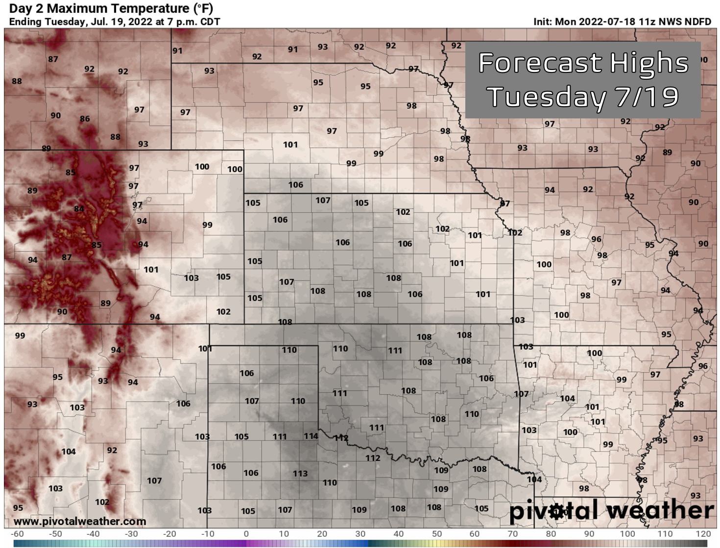
Very hot temperatures will unfold Monday for not only the Denver Metro area, but also a large portion of the western Great Plains — some places could even top 110°F in Nebraska, South Dakota and Texas.

Overnight temperatures have barely dropped with most areas holding near record overnight lows in the upper 60s to middle 70s across the Denver area (as of 6AM Monday).
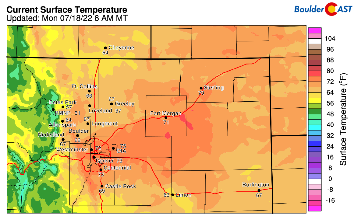
Overnight lows Monday morning were anything but “low”
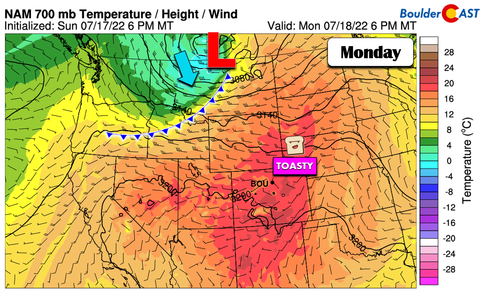
Mid-level temperatures look to the be the warmest yet across northeast Colorado, reaching ~20°C at 700mb by late afternoon on Monday. This would translate to temperatures right around 100 degrees for our entire area. Some spots will be a few degrees hotter. You may also notice a cold front in the graphic below tied to a low pressure moving along the Canadian border. This front will usher in cooler temperatures into the 70s and 80s for Tuesday on its backside. Unfortunately, that surface front will not reach the Front Range…
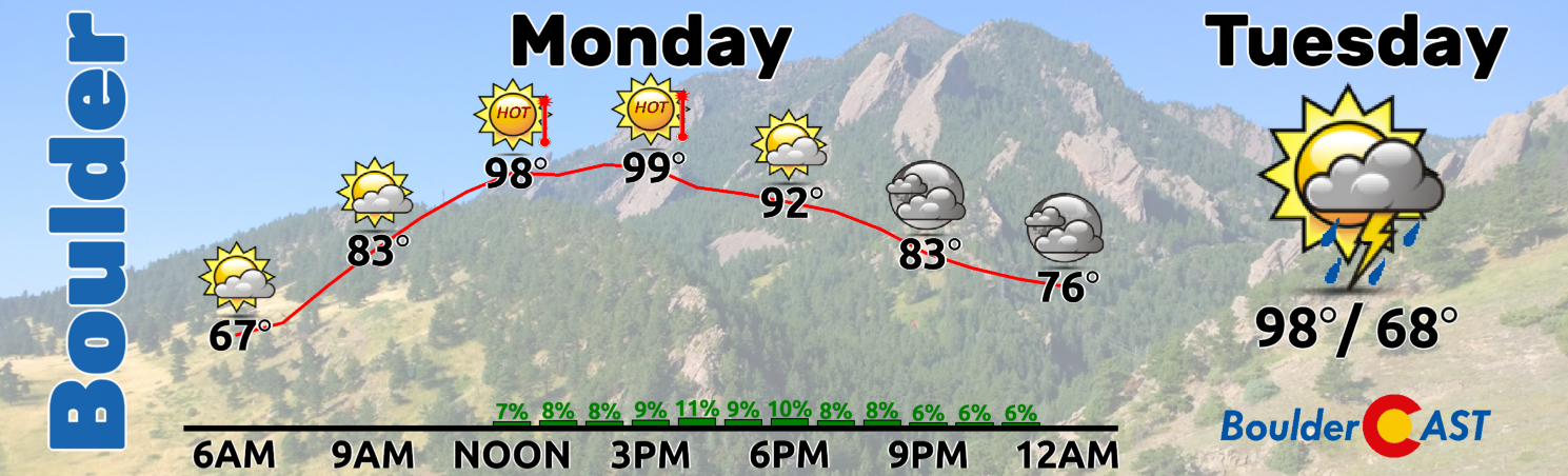
High temperatures on Monday will be very hot and close to record highs in our region. As you can see below, it will be a quick warm-up with readings already soaring into the upper 90s by noon. We’re forecasting a high of 100°F in Boulder. Coincidentally, the record high for July 18th is also 100°F set back in 2020. Double coincidentally, that date two years ago was also the last time Boulder recorded a triple-digit temperature. Denver’s record high on Monday is 99°F and that is almost certainly going to be busted. The only concern today that could impact our chance at record highs is the developing thundershowers during the 2PM to 9PM timeframe. We only have a 20% chance of rain in the forecast, but their gusty outflows and thickening clouds may keep some areas from reaching the triple digits.
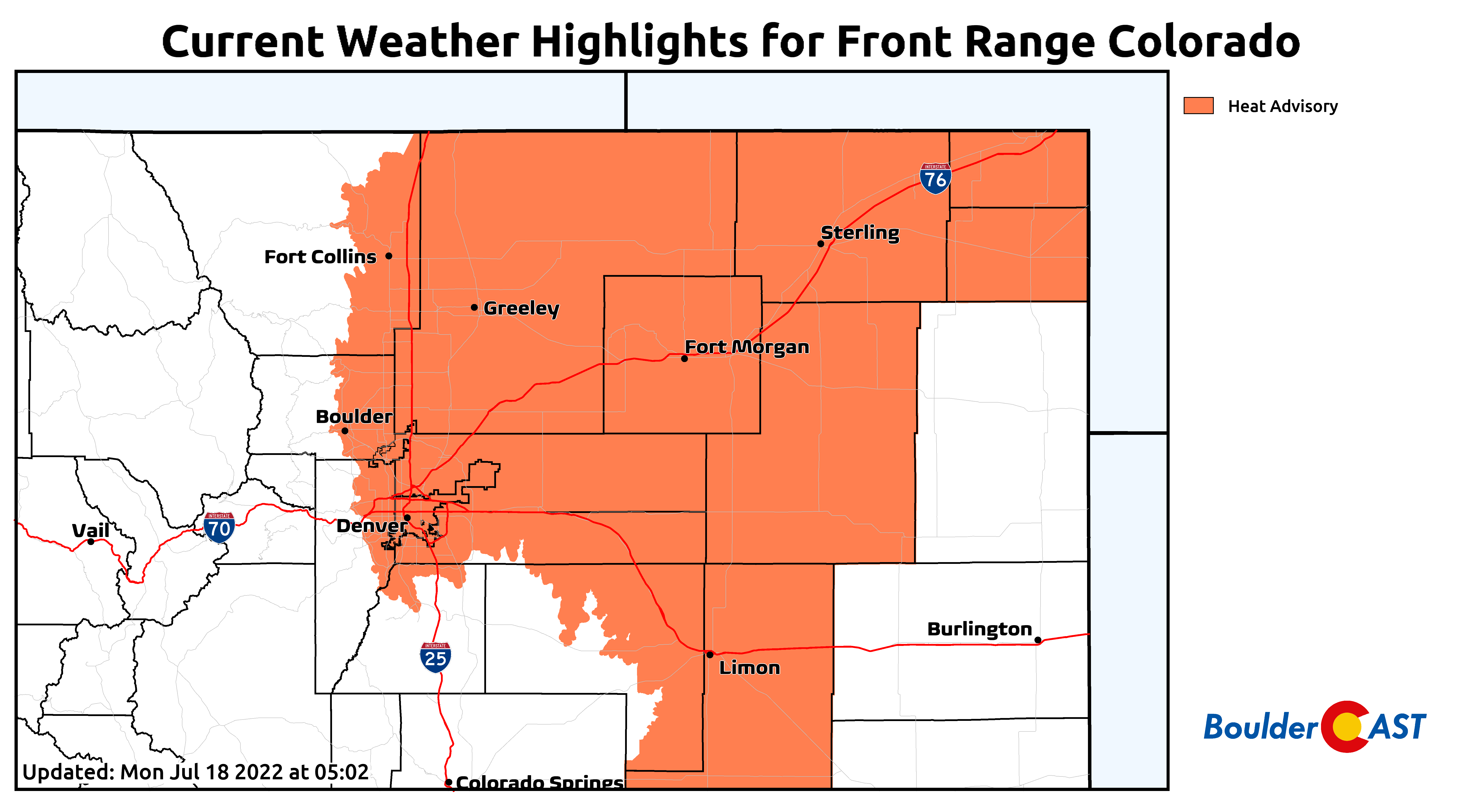
For this third time this year, Heat Advisories are posted for almost all of northeast Colorado with high temperatures everywhere below 5500 feet expected to land between 100 and 105°F on Monday. Stay hydrated and avoid being outside during the hottest time of the day if you can!
The good news is that Tuesday will be cooler. The bad news is that it will only be by a few degrees as the absolute hottest core of air shifts slightly southeastward. Highs will fall back into the middle to upper 90s — still rather hot and several degrees above normal. There will be a increase in storm coverage on Tuesday as well, but probably only in the higher terrain including the Foothills and Palmer Divide. We’re only putting a 10% chance for Boulder and Denver with most areas likely to remain high and dry in the heat.
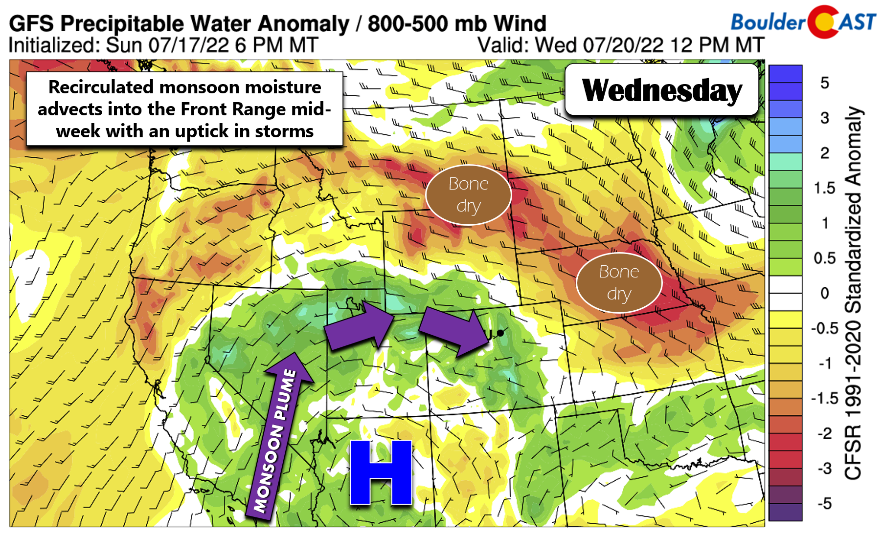
Wednesday will be the “coldest” day of the week as monsoon moisture makes a return to the region. It won’t be a direct flow of moisture, however. Instead, the monsoonal plume will be taking the scenic route to Colorado rotating around the persistent high pressure, which by mid-week will be sitting across Arizona. This roundabout pipeline of moisture will lead to a notable uptick in storm coverage across the area. Storms and clouds will be developing earlier in the day which is the main reason temperatures will be cooler overall. Highs on Wednesday will be in the lower 90s with scattered afternoon and evening storms.
Thursday will be very similar to Wednesday with again a decent chance of late-day storms. Temperatures will climb a few degrees back into the middle 90s.
According to most weather models, Friday appears to entertain a slight reduction in moisture availability across the Front Range, but this remains somewhat questionable being so far out in the forecast. With this, clouds/storms should be reduced and we could easily see temperatures make another attempt at 100 degrees.
Looking ahead: Staying hot
The pesky and hot ridge of high pressure over the Four Corners won’t budge much in the extended forecast either. The GEFS 500mb height anomaly forecast animation below runs for the next seven days. Notice how the ridge largely remains intact during this timeframe. It does flatten out a little and the center is forecast to shift eastward into the southern Great Plains by the end of the upcoming weekend. Not only would this shift take the core of the hottest air away from Colorado, it would also be a more favorable position to potentially revive the monsoon and/or allow more meaningful cold fronts to reach our area.
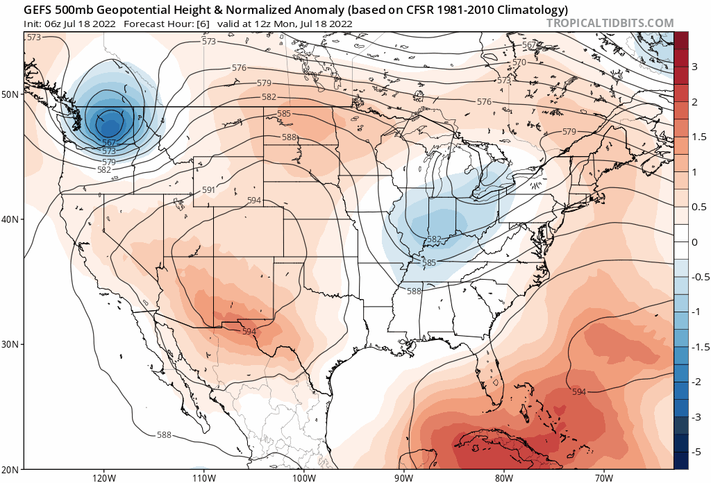
GFS ensemble mean 500mb height anomaly forecast animation over the next seven eight days
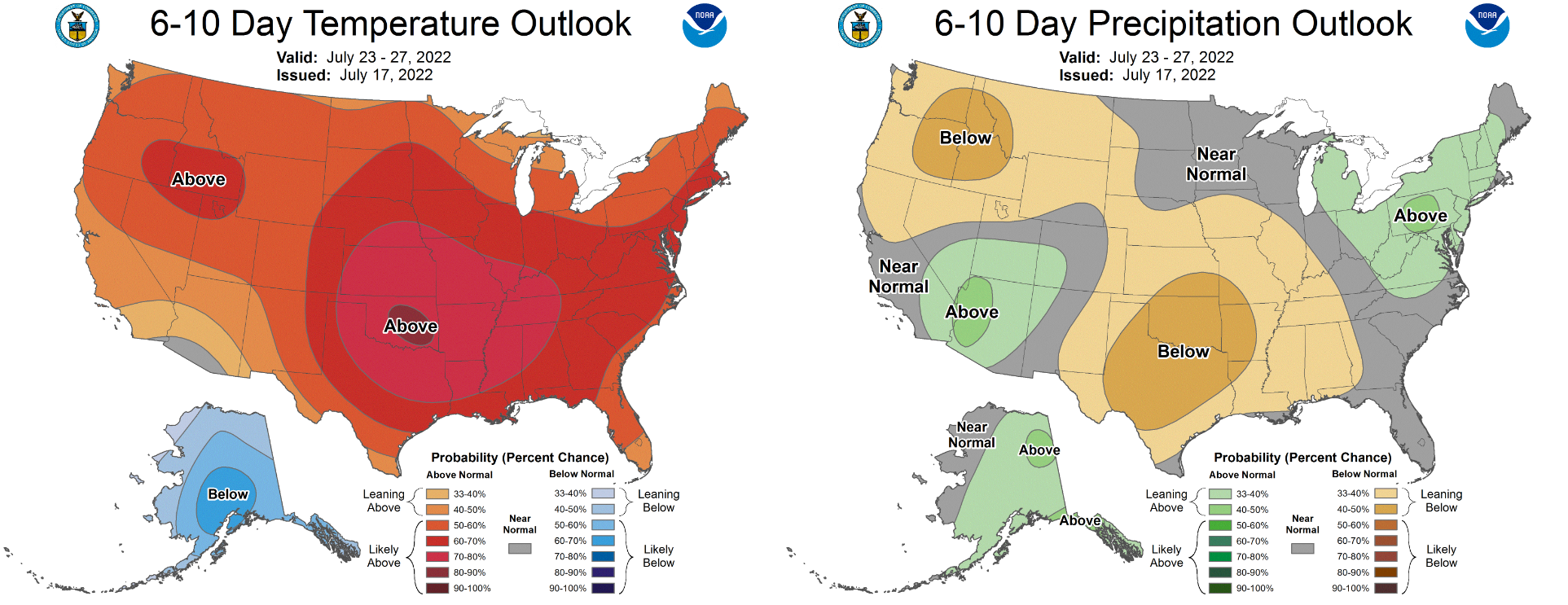
The CPC outlook for Days 6 to 10 doesn’t look great for Colorado, though we do clearly see the result of the ridge’s migration eastward: the epicenter of the heatwave sets up over the southern Plains and Texas, while the Four Corners will see above normal rain chances as the monsoon flares up once again.
Stay cool, folks! It’s going to be a brutally hot week and weekend ahead…

Stay up to date with Colorado weather and get notified of our latest forecasts and storm updates:
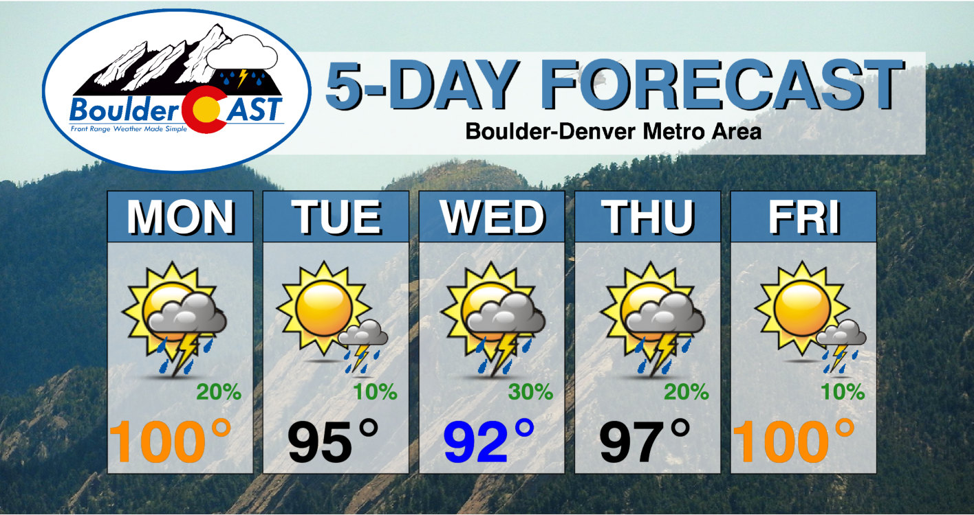
Forecast Specifics:
Monday: Partly cloudy and very hot with near-record high temperatures possible in the low 100s. Just a slight chance of afternoon/evening thundershowers capable of producing light rainfall and gusty winds.
Tuesday: Somewhat cooler, but still hot with isolated late-day thunderstorms, mainly in the higher terrain. Highs in the mid to upper 90s on the Plains with lower 80s in the Foothills.
Wednesday: The “coolest” day of the week with storm clouds building earlier in the day. Expect scattered afternoon and evening storms taking the edge of the heat. Highs reach the lower 90s across the Plains with upper 70s in the Foothills.
Thursday: Warming up. Morning sun turning cloudy in the afternoon with scattered late-day thunderstorms possible. Highs in the middle 90s across the Plains with lower 80s in the Foothills.
Friday: Very hot with a slight chance of late-day thunderstorms. Temperatures will be near-record values close to 100 degrees on the Plains and in the upper 80s in the Foothills.
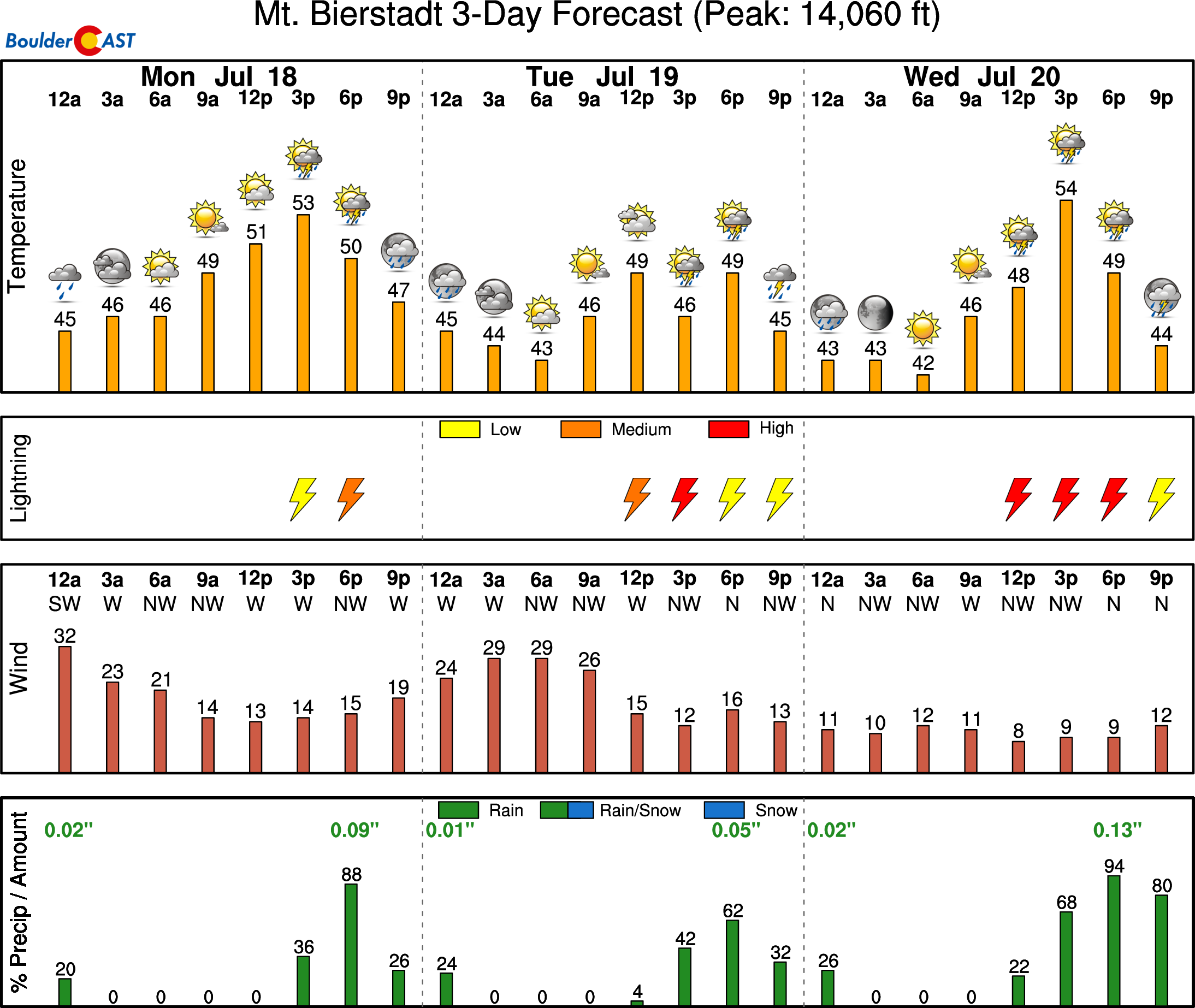
High Country: There will exist a chance of storms and dangerous lightning each day over the High Country this coming week. Make sure to check the forecast if you are headed to the Mountains. There will be rain around in some form nearly every day this week up there.
Help support our team of Front Range weather bloggers by joining BoulderCAST Premium. We talk Boulder and Denver weather every single day. Sign up now to get access to our daily forecast discussions each morning, complete six-day skiing and hiking forecasts powered by machine learning, first-class access to all our Colorado-centric high-resolution weather graphics, bonus storm updates and much more! Or not, we just appreciate your readership!
Spread the word, share the BoulderCAST forecast!


You must be logged in to post a comment.