
With the monsoon getting suppressed and a hot pattern taking hold this weekend, both Saturday and Sunday could get Boulder to the elusive 100-degree mark for the first time in nearly two years. We discuss the cause of this heatwave, how hot it will get around Boulder and Denver this weekend (and next week), and when we expect cooler temperatures to arrive.
Key Highlights from This Post:
- A hot weather pattern will suppress the monsoon and push our temperatures to near 100°F both days this weekend
- Record highs likely to be tied or broken this weekend
- A cold front is scheduled for Sunday night bringing a nice cooldown for Monday
- The criteria for the Heat Advisory, something historically almost never issued in Denver, has changed this year making it more commonplace for us — including this weekend
- Another hot pattern will develop next week with 90s and possibly some 100s showing up again in the extended forecast
Help support our team of Front Range weather bloggers by joining BoulderCAST Premium. We talk Boulder and Denver weather every single day. Sign up now to get access to our daily forecast discussions each morning, complete six-day skiing and hiking forecasts powered by machine learning, first-class access to all our Colorado-centric high-resolution weather graphics, bonus storm updates and much more! Or not, we just appreciate your readership!

T
he hottest temperature so far in 2022 in Boulder was 99°F reached back on June 11th — a day which Denver was able to crack 100. Both cities have a chance at triple digit temperatures this weekend, especially on Sunday, as a large ridge of high pressure builds across Colorado. This pattern shift can be seen in the GEFS 500mb height anomaly animation below. Notice how the center of the ridge develops directly over southern Colorado on Saturday and sticks around into Sunday.
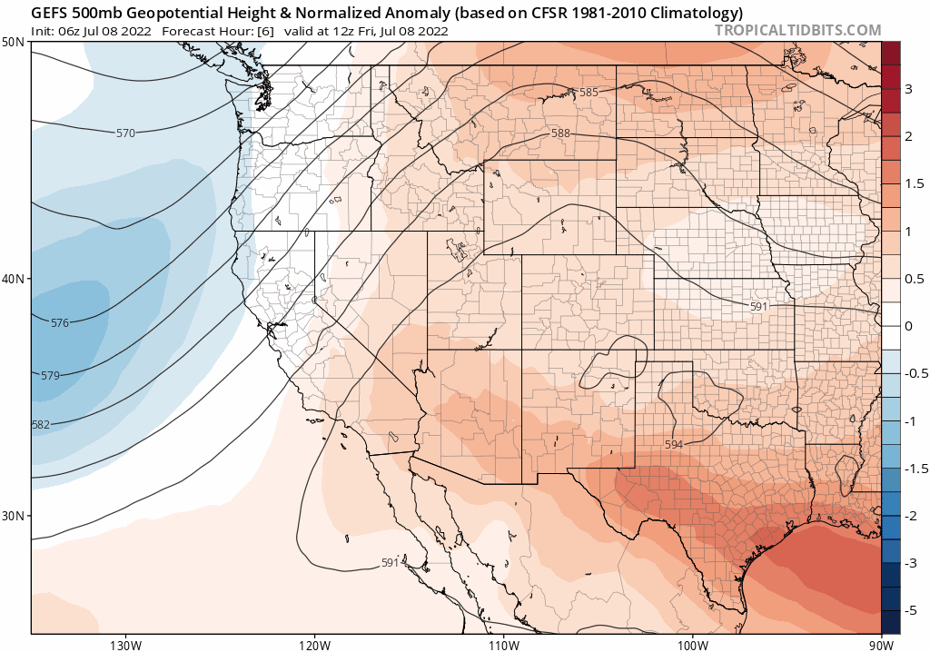
For a number of reasons, this atmospheric setup will help produce near-record heat right around the century mark in our area:
- Large-scale subsidence from this anomalously strong ridge will inhibit cloud and precipitation formation over the area allowing for mostly sunny skies (solar heating will be close to maximum)
- The monsoon moisture plume will get redirected westward into Arizona and Utah, starving our area for moisture and further contributing to the lack of clouds and storm development over the Front Range
- Winds rotating around the high will be blowing into Colorado from the southwest and west-southwest — straight from the very hot deserts of Arizona and southern Utah

While Denver averages about one 100-degree day per year, Boulder sees only about one every two years. It may come as a surprise, but Boulder is almost always cooler than Denver during the summer months, usually by a couple of degrees. There are a few notable reasons for this observed temperature shortcoming:
- #1 CLOUDS: Summertime cumulus clouds and storms routinely build over Boulder earlier in the day than Denver as they almost always initiate over the higher terrain first and move eastward. This allows Denver to capitalize on more solar heating during the late morning and early afternoon.
- #2 ELEVATION: Boulder is slightly higher in elevation than Denver, which has cooling implications in the daytime. For summer heat, lower elevation is better. Just look at Death Valley!
- #3 TERRAIN PROXIMITY: Boulder’s closeness to the Foothills tends to produce a weak upslope breeze during summer mornings which has a slight cooling effect. As the sun rises to the east, it strikes the eastern slopes of the Foothills/Mountains at the most efficient angle. This creates what is known as a valley breeze which is similar to a sea breeze. Both are created due to differential heating of two nearby locations. It’s not until around midday that the sun rises high enough to reduce the differential heating and kill off the valley breeze.
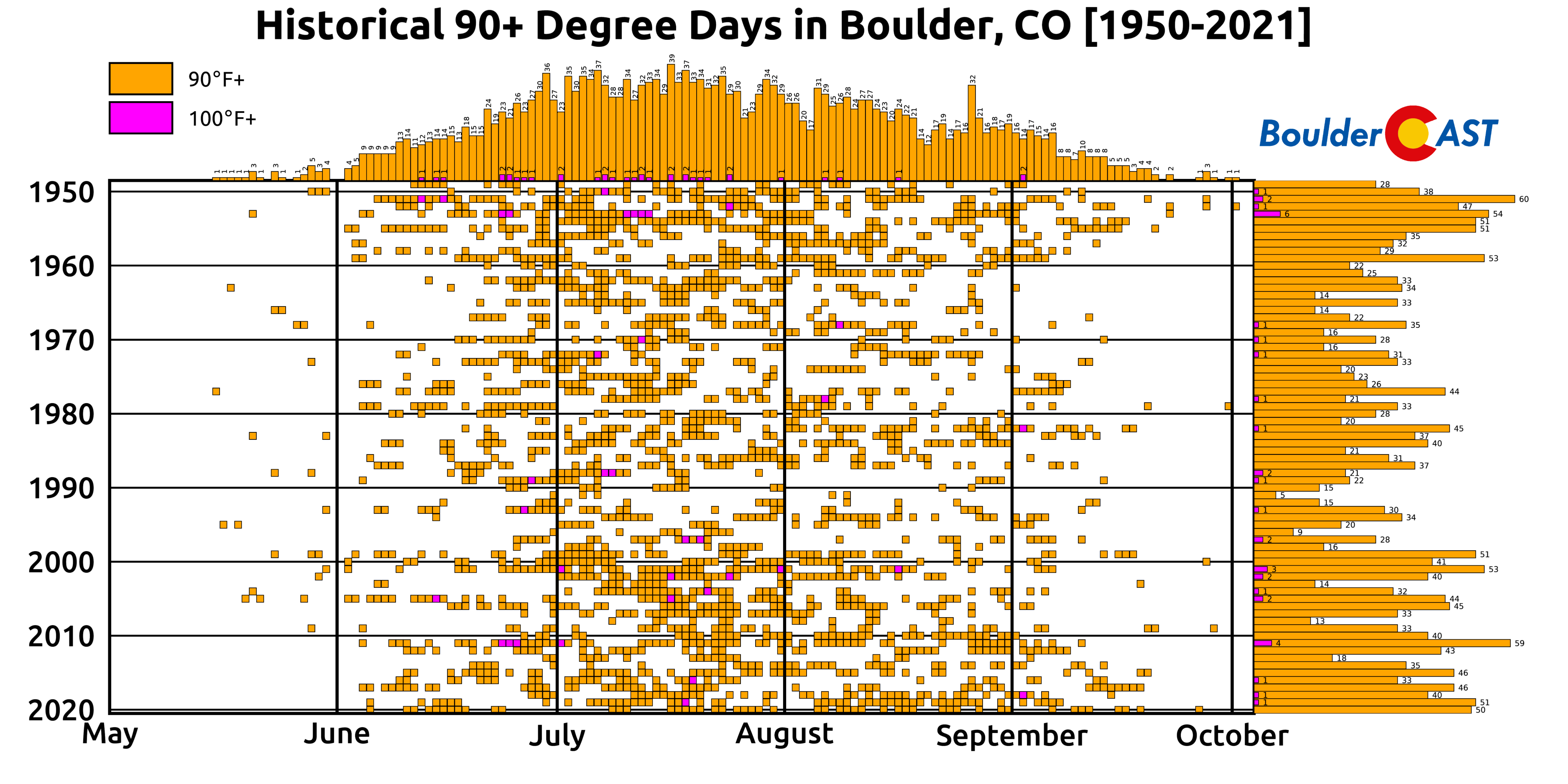
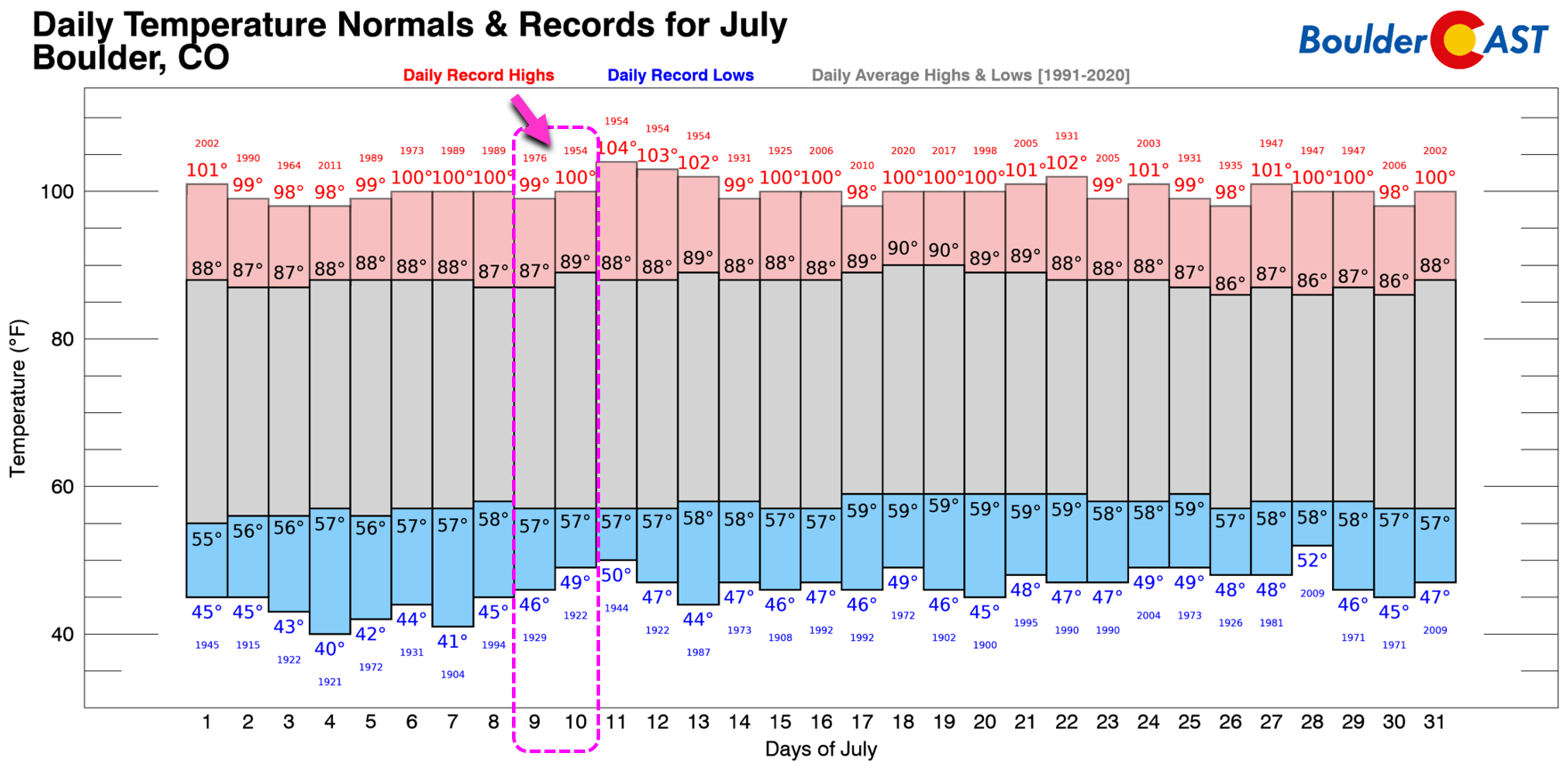
Reaching 100 degrees in Boulder is no easy feat. It’s not all that rare, but it is certainly uncommon. As shown in the graphic below, there have only been 36 100°+ days in the last 72 years in Boulder. The most common timeframe for triple-digit heat is from late June through late July, but they have been known to occur as early as June 12th and as late as September 2nd (twice!). Our last 100-degree day in Boulder was nearly two years ago — so we are about due! Shockingly, it’s been a decade since the city last hit 101°F — that happened the day after the Flagstaff Fire ignited in the brutally hot and dry June 2012.
Today is the 10 year anniversary of the #FlagstaffFire in #Boulder. 🔥 It was sparked by a monsoon lightning strike amidst a terrible statewide drought. In the end, the wildfire burned about 350 acres and forever changed the landscape of Bear and South Boulder Peaks #cowx pic.twitter.com/LrvPfdVLNa
— BoulderCAST Weather (@BoulderCAST) June 26, 2022
So how hot will it actually get this weekend?
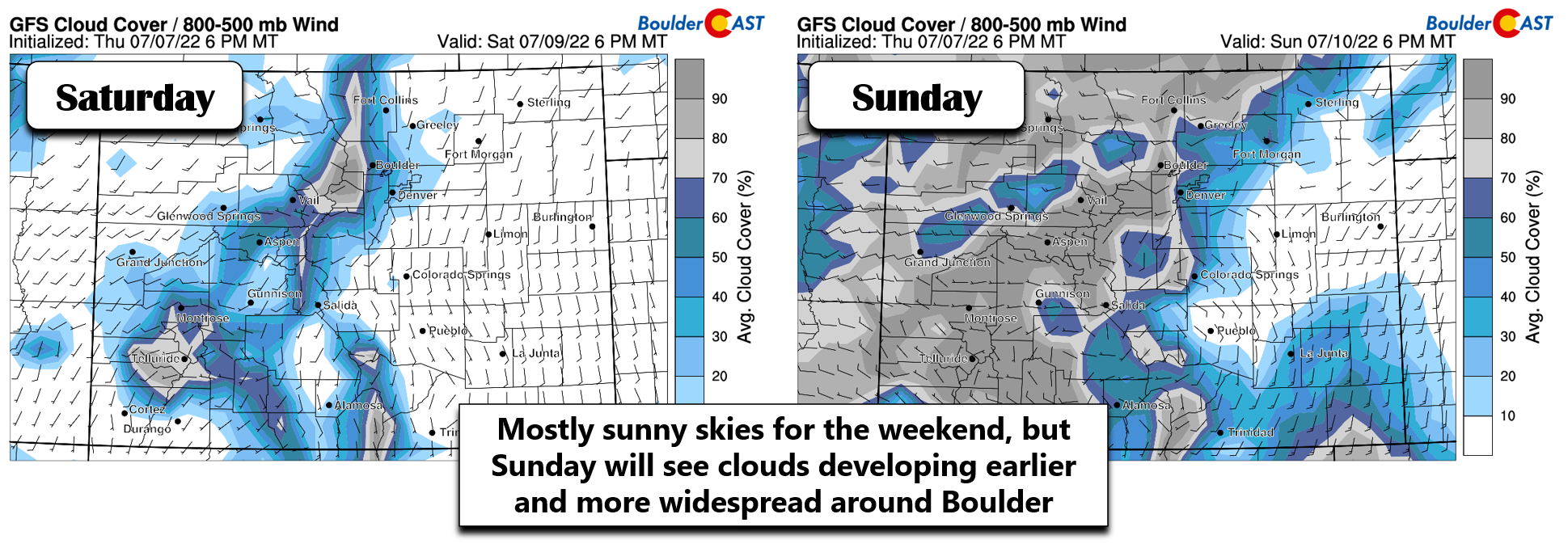
As mentioned, the monsoon will be shunted away from our area for the weekend. Despite this, enough moisture will remain underneath the ridge for some clouds and a few storms to develop. Both Saturday and Sunday will begin with full sunshine, but cumulus clouds forming over the higher terrain will spill into the Denver area in the afternoons and evenings helping to potentially cool things off a little bit. Saturday it looks the clouds will arrive later, while Sunday they will be earlier and more widespread — particularly around Boulder.
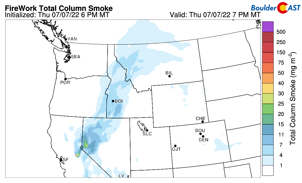
Furthermore, unlike years past and even the last time we flirted with triple digits a month ago, we’ll be home free from wildfire smoke this weekend. Thick smoke causes a chunk of the sun’s energy to be reflected and absorbed reducing the amount of sunlight reaching the ground. This has a net cooling effect on temperatures. Smoke won’t be a problem this weekend — unless of course new large wildfires break out nearby….
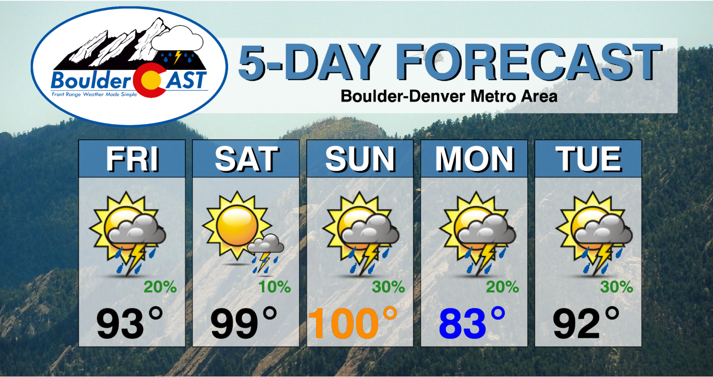
In short, both days will end up with nearly the same temperatures across the Front Range. Saturday will be sunnier with very low chance for rain but the airmass will be “cooler”. Sunday will have a warmer overall airmass thanks to persistence of the pattern, but clouds will form earlier in the day and rain chances increase a bit (perhaps there will be some cool outflows?). Both days will have some aspects favoring record heat, but others hindering it. Right now our forecast calls for a high of 99°F in Boulder on Saturday, and then 100°F on Sunday.
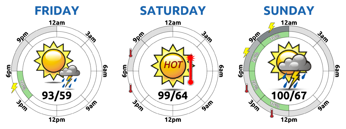
Coincidentally, these forecast highs are exactly the existing record highs for the city which were set back in 1976 and 1954, respectively. Denver proper (and much of the Denver Metro area in fact) is favored to reach 100°F both days, with Sunday possibly climbing to 102°F or so.
The good news? By late Sunday, the big ridge over Colorado will begin to flatten out as a disturbance moves across southern Canada. This will bring a long-tailed cold front into northeast Colorado sometime Sunday night with temperatures on Monday plummeting approximately 20 degrees back into the lower to middle 80s. Not cold by any stretch of the imagination, but certainly cooler and more comfortable.

The reprieve from the toaster oven will be short-lived, however (isn’t it always?). Medium-range model guidance shows a more pronounced ridge reforming over the Four Corners area by midweek — that one is projected to stick around for quite a while!

This newly forming ridge will quickly heat our temperatures back into the 90s by Tuesday with 100s possibly make a triumphant return as early as Thursday of next week to the Front Range! Sigh….
Finally, we wanted to talk about the Heat Advisory highlight that is likely to be issued by the National Weather Service (NWS) this weekend for our area. The Heat Advisory has historically been quite rare for the Denver area since it is based on temperature and heat index thresholds that really don’t occur here. In fact, prior to the one earlier this summer, the only other time a Heat Advisory was issued in Denver was in 2008.
It's been 14 years since the last time Denver has been in under a Heat Advisory (August 2008). This one is mostly because of the combination of near-record highs and the moderate wildfire smoke expected on Friday #Cowx https://t.co/J7yVXuntxh pic.twitter.com/HMMUOb5ib9
— BoulderCAST Weather (@BoulderCAST) June 16, 2022
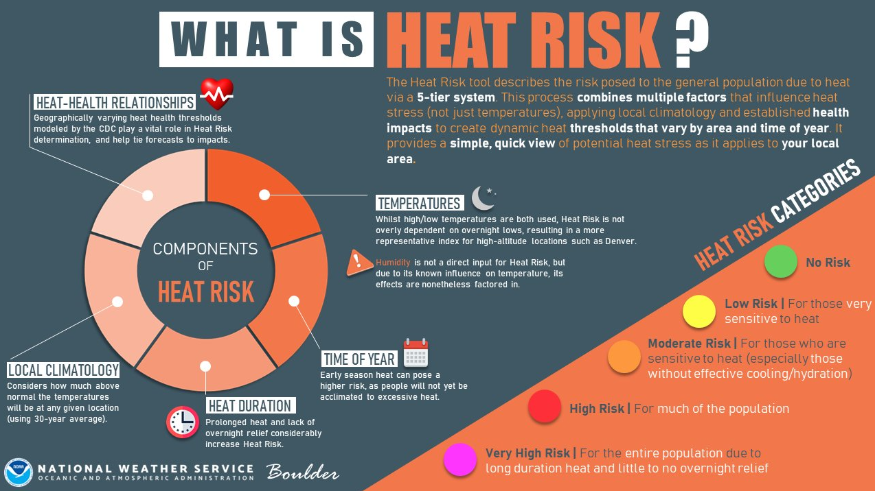
In order to increase awareness and capture the actual danger to the population of regionally-specific heat waves, the NWS has made changes to the Heat Advisory. They are now based on new subjective criteria feeding into general “heat risk” categories. As detailed in the diagram below, heat risk takes into account many factors in addition to just the sensible temperature. This will result in Heat Advisories becoming much more common in the Denver area. Basically anytime it gets close to 100 degrees, we should expected them to be issued for the Boulder-Denver area.
That’s all for now. Be smart this weekend and don’t push yourself too much in the heat. Stay cool!

Stay up to date with Colorado weather and get notified of our latest forecasts and storm updates:
We respect your privacy. You can unsubscribe at any time.
Help support our team of Front Range weather bloggers by joining BoulderCAST Premium. We talk Boulder and Denver weather every single day. Sign up now to get access to our daily forecast discussions each morning, complete six-day skiing and hiking forecasts powered by machine learning, first-class access to all our Colorado-centric high-resolution weather graphics, bonus storm updates and much more! Or not, we just appreciate your readership!
.


You must be logged in to post a comment.