
Warm, gusty weather is kicking off the first full week of 2026, but the atmosphere has a few twists lined up as we move toward the weekend. A stubborn ridge will keep us mild early on as downslope winds ramp up fire concerns. However, a developing trough later in the week will turn us much colder — with even the possibility of snow for Boulder and Denver if the storm track cooperates. The details are still evolving, but there’s plenty to watch in the days ahead.
This week’s highlights include:
- 🌤️ Mild pattern: Southwest flow under early‑week ridging keeps Colorado dry and unseasonably warm.
- 🌡️ Warm start: Highs run 10–15° above normal, topping out in the upper 50s to low 60s through midweek.
- 🌬️ Blustery winds: Downslope gusts of 25–45 MPH Monday and Tuesday elevates fire danger, though humidity stays high enough to prevent Red Flag conditions.
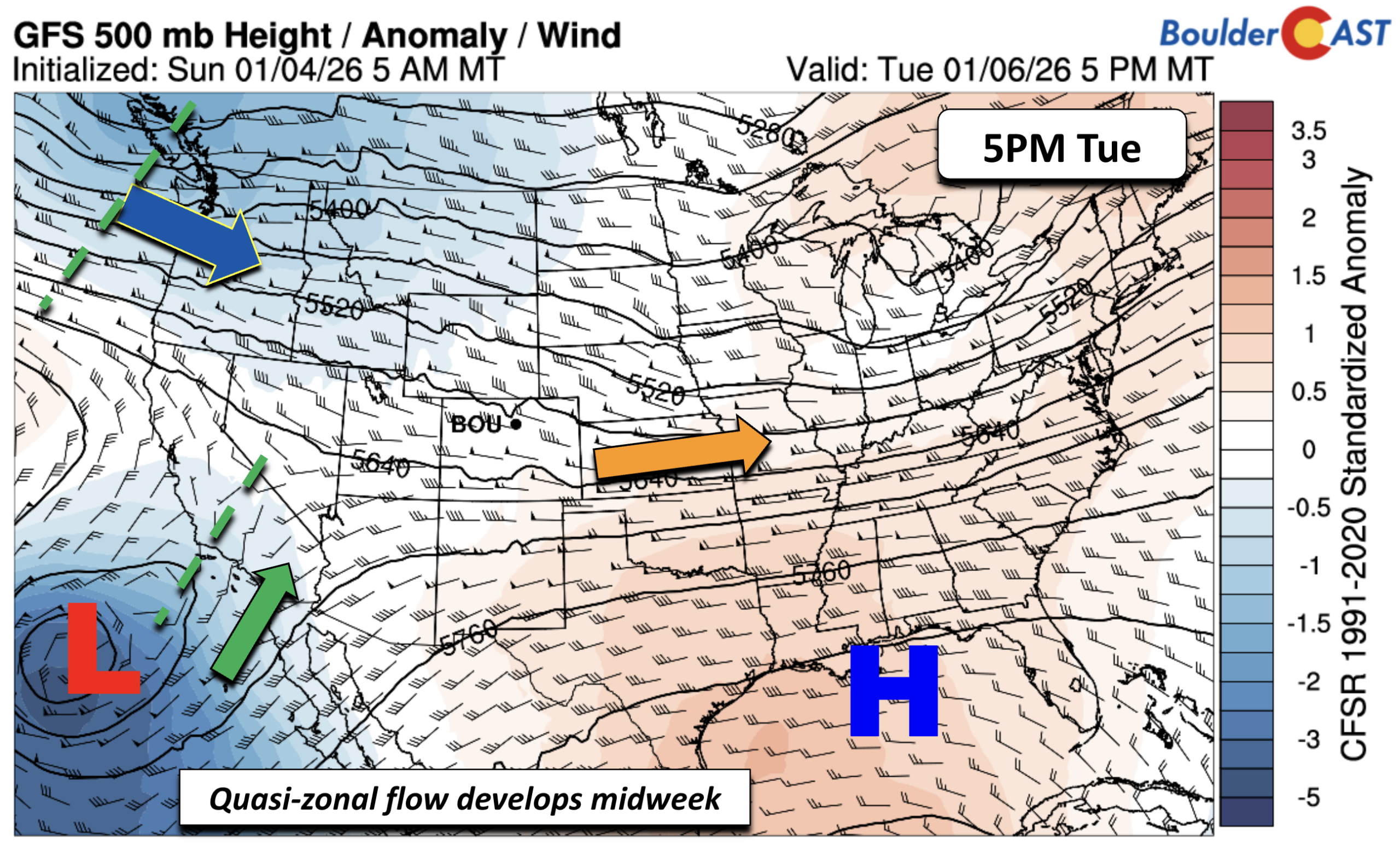
- 🌎 Pattern shift: Ridge flattens midweek as a Canadian trough digs south and a California low comes onshore. These two features are being watched closely as they could produce winter weather for us.
- ❄️ Late‑week snow uncertainty: Models disagree on where the developing trough sets up, leaving snow chances in the Front Range highly track‑dependent and still TBD.
- 📉 Colder end to week confirmed: Regardless of any snow, temps will fall to near 40° Thursday and around freezing by Friday.
- ⛰️ Two waves of Mountain snow: Widespread light to moderate snow is expected in the Mountains this week in two waves — one Monday and another on Thursday.
DISCLAIMER: This weekly outlook forecast is created Monday morning and covers the entire upcoming week. Accuracy will decrease as the week progresses as this post is NOT updated. To receive daily updated forecasts from our team, among many other perks, subscribe to BoulderCAST Premium.

Go Premium, get all the perks.
Daily Forecast Updates
Get our daily forecast discussion every morning delivered to your inbox.
All Our Model Data
Access to all our Colorado-centric high-resolution weather model graphics. Seriously — every one!
Ski & Hiking Forecasts
6-day forecasts for all the Colorado ski resorts, plus more than 120 hiking trails, including every 14er.
Smoke Forecasts
Wildfire smoke concentration predictions up to 72 hours into the future.
Exclusive Content
Weekend outlooks every Thursday, bonus storm updates, historical data and much more!
No Advertisements
Enjoy ad-free viewing on the entire site.
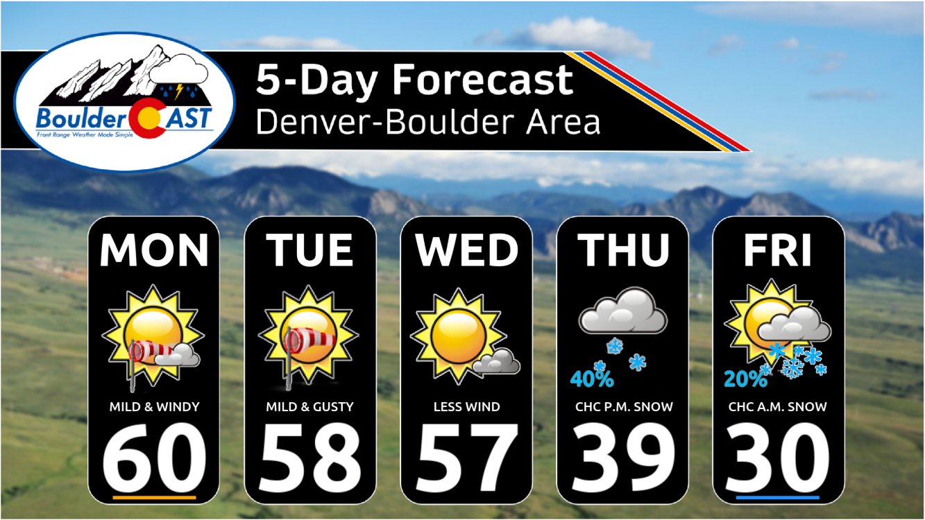
A warm start to the first full week of 2026
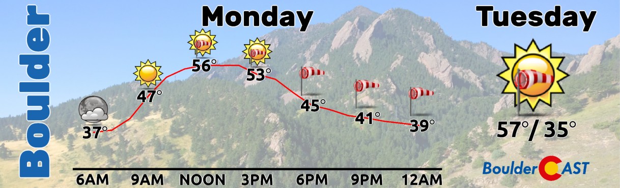
The first full week of January 2026 is kicking off on an unseasonably warm note. For reference, normal highs this time of year sit in the mid to upper 40s across Denver and Boulder. Instead, we’ll be running a good 10–15 degrees above that, with highs in the upper 50s to lower 60s through at least midweek.
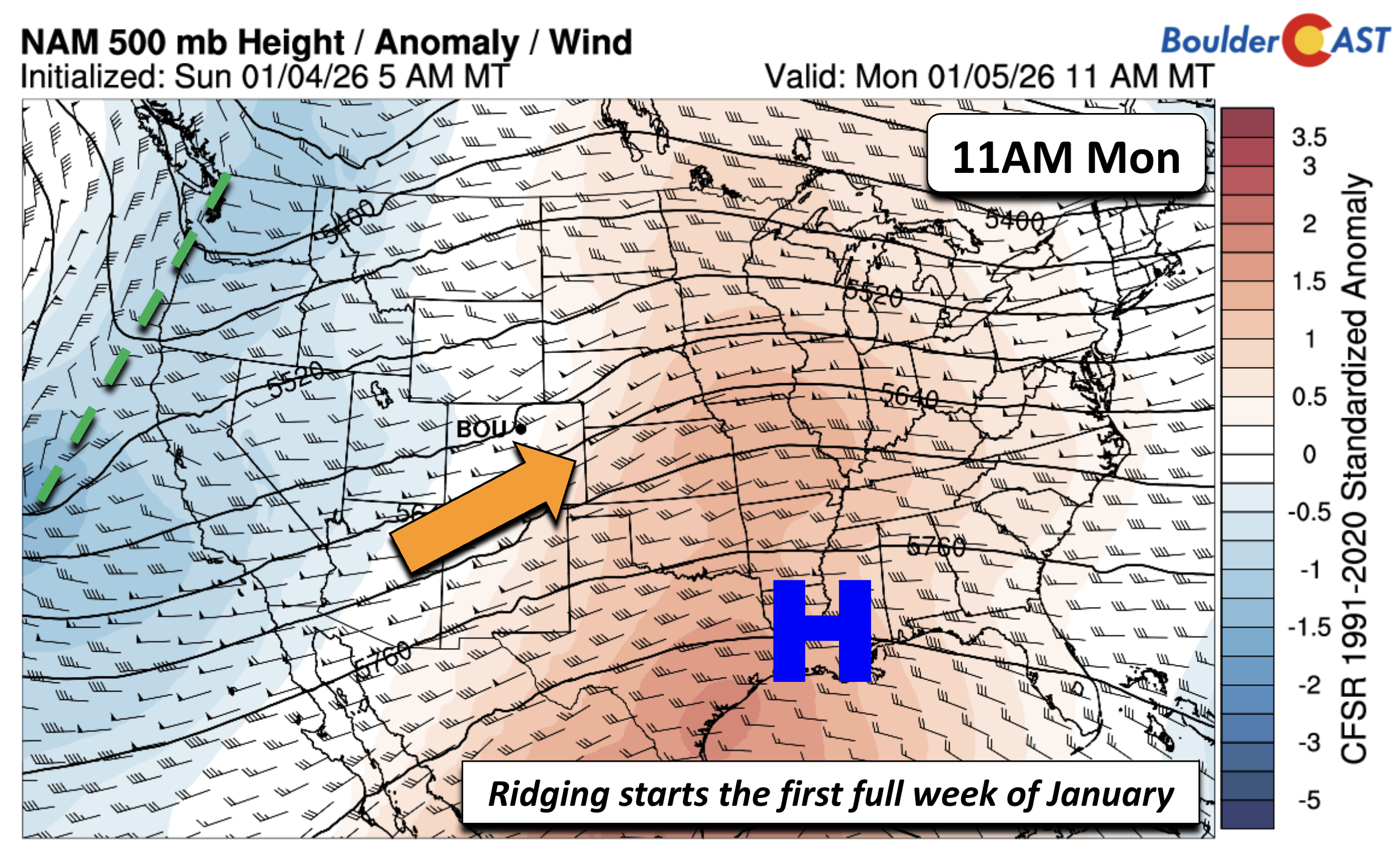
We start the week under broad ridging stretching from the northern Gulf of Mexico into the central U.S. At the same time, a weak trough lingering off the West Coast is helping pump southwest flow into Colorado. The result: mild, dry weather and plenty of sunshine to start January.
By late Tuesday into Wednesday, the pattern doesn’t change much, but the ridge does begin to flatten as a deepening trough digs into western Canada. That shift nudges us toward a more quasi‑zonal flow. Meanwhile, a closed low will be spinning off the California coast. Those two features may eventually interact later this week, potentially fueling a strong winter storm somewhere in the Midwest. And if they phase just right, we might be able to squeeze out a little snow along the Front Range too.
Fire danger will be elevated Monday and Tuesday thanks to westerly downslope winds gusting 25–45 MPH, especially around Boulder. The good news is that humidity stays relatively high—generally 20 to 35%—during the windiest periods, which should keep fire danger from getting out of hand.
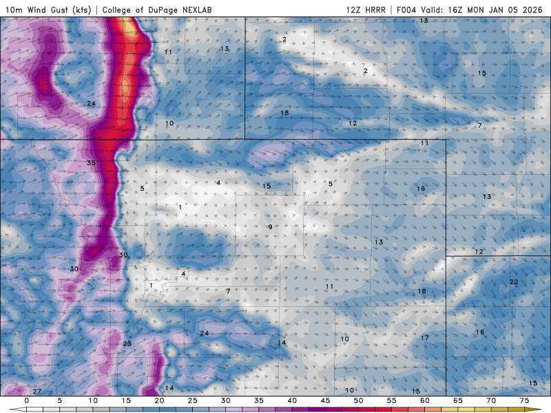
HRRR wind gust forecast animation for Monday AND Tuesday across the Front Range
Expect highs in the upper 50s or so Monday and Tuesday with pesky downslope winds making it feel a little cooler.
Keeping an eye on a late‑week snow chance
We’ve been hinting at the possibility of snowflakes later this week, and that signal is still on the table for sometime late Thursday into Friday. If you only looked at the GEFS ensemble for Denver, you might walk away thinking this is a non‑event. But a closer look shows several outliers pointing to at least a moderate snow potential.
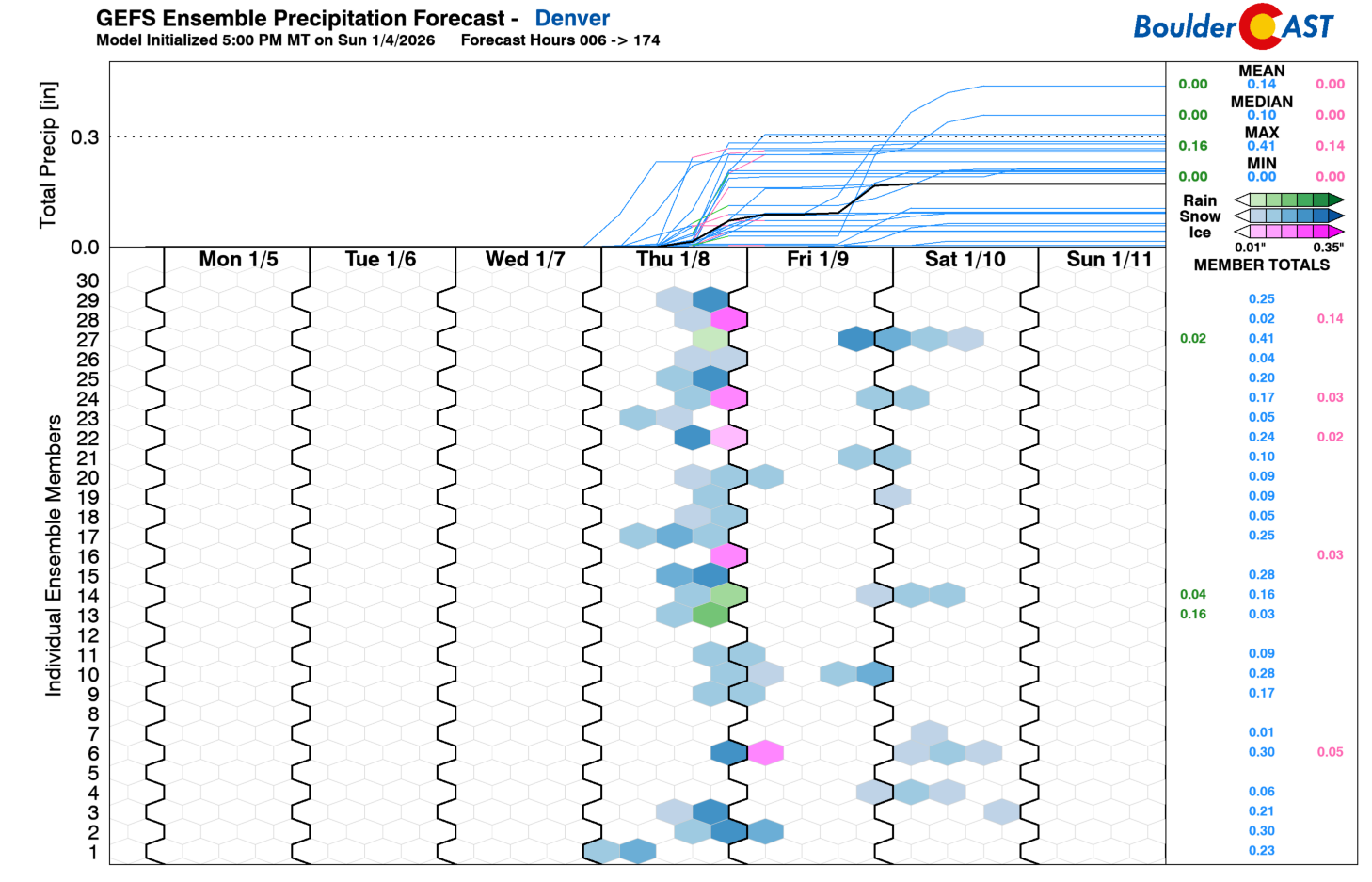
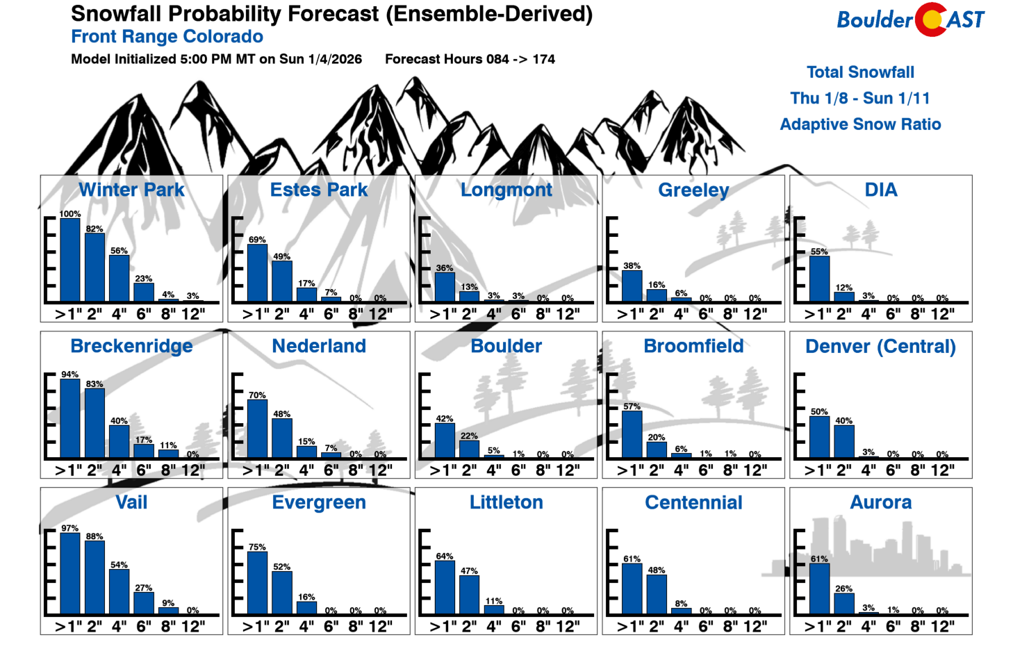
Snowfall Probabilities for the Wednesday–Saturday window also show only a modest 40–50% chance of at least an inch across the Metro area. So what’s driving the uncertainty?
In short: the models don’t agree on where the late‑week trough will set up. We know a trough will form somewhere over the central U.S., possibly as far west as the Four Corners. But it could also end up farther north into Wyoming/Nebraska, or farther south and east into Oklahoma/Kansas. There’s even a more progressive solution that develops only a weak surface low.
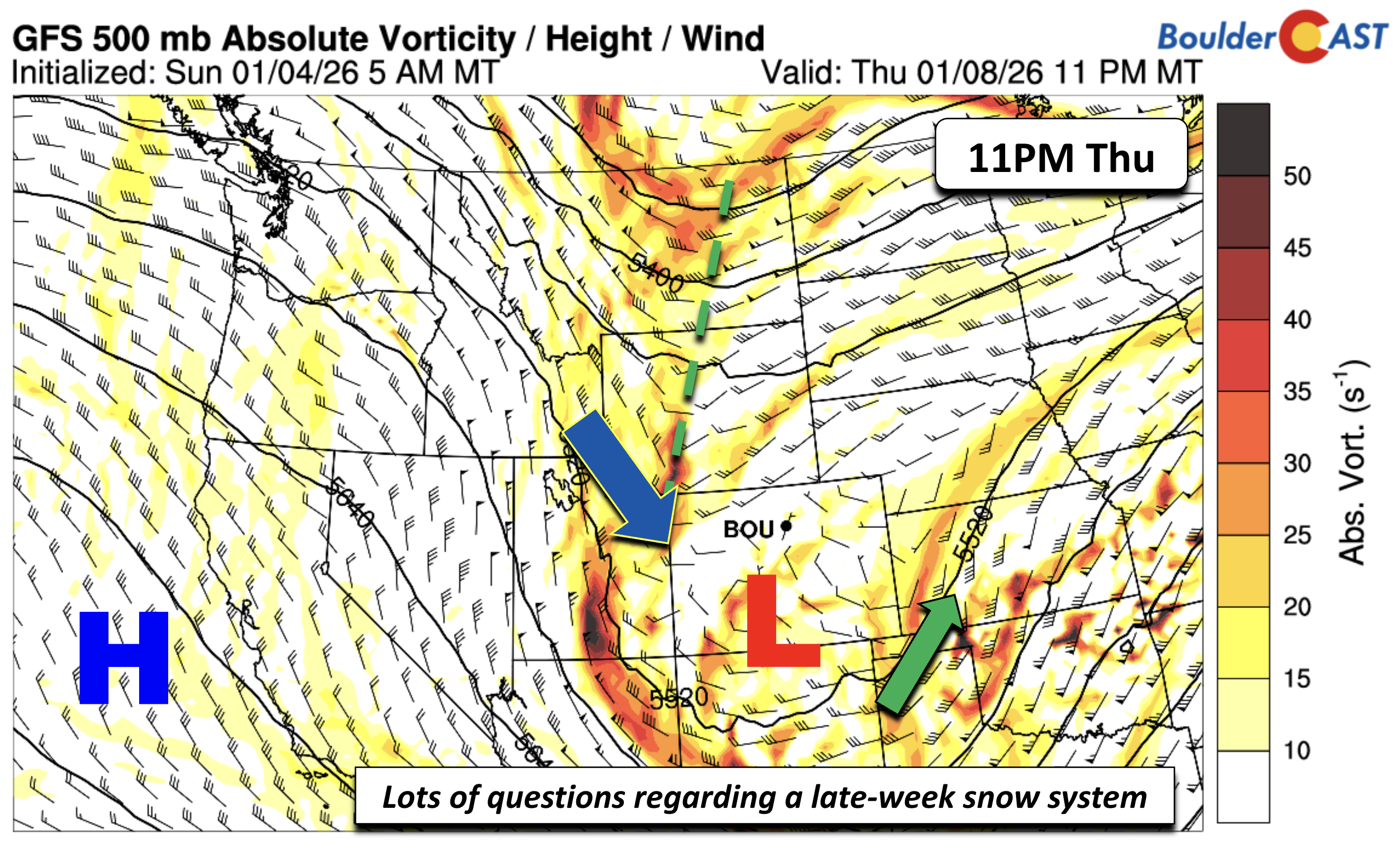
All of these possibilities will eventually converge into a single outcome, but we’ll need another day or two before confidence improves. The exact track will determine whether we see meaningful upslope—or very little at all. A farther‑east system favors northwest winds and limited snow. A farther‑west/south track puts us in a much better position for accumulation.
The GFS solution keeps the low too far east and south to deliver much snow to the Front Range.
The Euro, on the other hand, is more generous—showing widespread mountain snow and a few inches possible for the Boulder-Denver area.
Regardless of the track, temperatures will trend colder Thursday and Friday. Right now we’re forecasting highs near 40° Thursday and close to freezing Friday, but those numbers could drop if stronger Canadian air digs south.
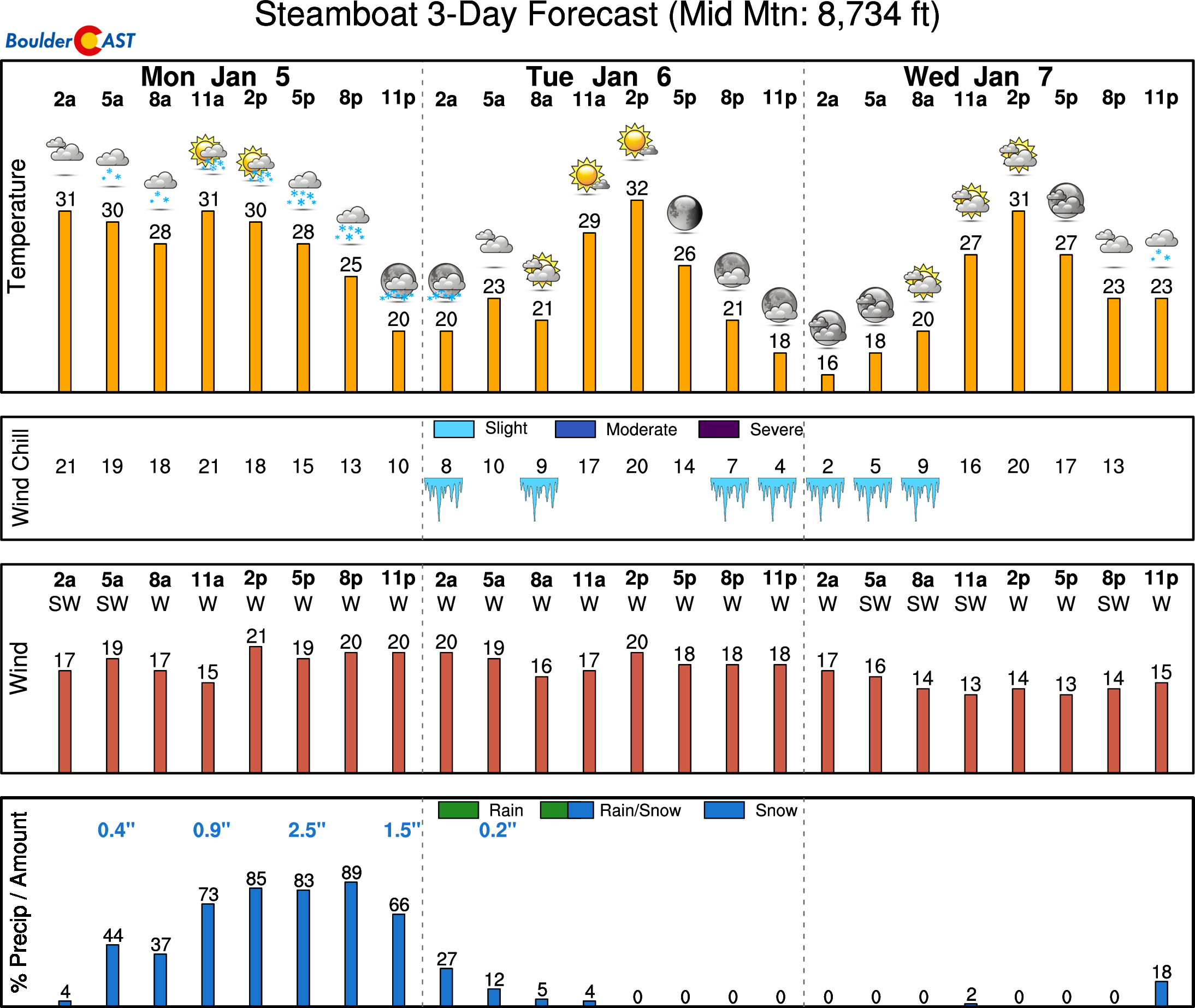
Finally, snow will be widespread in the Mountains this week, coming in two waves — one during the day Monday into Monday evening, and another with the late-week trough Thursday into early Friday. 3-6 inches are expected on Monday in most resorts (up to 8 inches at Steamboat), with another 3-8 inches expected later in the week.
We’ll have plenty more to say as the pattern shift in the coming days. For now, enjoy the warm, breezy start to 2026 while we monitor precisely how the late‑week potentially snowy setup comes together.
Forecast Specifics:
Monday through Wednesday: Lots of sunshine, warm and windy. Highs mild in the middle 50s to lower 60s on the Plains and upper 40s to around 50 in the Foothills. Gusts from the west-northwest Monday and Tuesday could reach values of 45 MPH at times. Fire danger will be elevated but not critical. Winds will be much reduced on Wednesday.
Thursday: Mostly cloudy with a chance of snow in the afternoon and evening. Highs turning cooler in the 30s to lower 40s for the Plains and lower 30s in the Foothills.
Friday: A chance of lingering snowflakes in the morning, then mostly sunny by afternoon. Highs colder around freezing on the Plains with 20s in the Foothills.
Weekend: A moderating trend may take shape late in the weekend, with highs possibly in the 40s by Saturday with 50s for Sunday.
DISCLAIMER: This weekly outlook forecast is created Monday morning and covers the entire upcoming week. Accuracy will decrease as the week progresses as this post is NOT updated. To receive daily updated forecasts from our team, among many other perks, subscribe to BoulderCAST Premium.
Go Premium, get all the perks.
Daily Forecast Updates
Get our daily forecast discussion every morning delivered to your inbox.
All Our Model Data
Access to all our Colorado-centric high-resolution weather model graphics. Seriously — every one!
Ski & Hiking Forecasts
6-day forecasts for all the Colorado ski resorts, plus more than 120 hiking trails, including every 14er.
Smoke Forecasts
Wildfire smoke concentration predictions up to 72 hours into the future.
Exclusive Content
Weekend outlooks every Thursday, bonus storm updates, historical data and much more!
No Advertisements
Enjoy ad-free viewing on the entire site.
Enjoy our content? Give it a share!


You must be logged in to post a comment.