
The week begins quiet on Monday, but things turn notably snowy and much colder by Tuesday. We’re tracking a winter storm that will bring accumulating snow to all of eastern Colorado Tuesday morning into the afternoon hours with a dicey morning commute all but guaranteed. We discuss the timing of the storm and expected snowfall amounts across the region. Further out, another round of snow could accompany a weak system on Thursday, but that is still evolving. Read on for all the details.
Premium Storm Update (1/25/22 6:00AM): We do a final check of the latest model runs and how they compare to what is actively occurring across northeast Colorado early Tuesday morning. We give our final thoughts on the storm and discuss the next chance of light snow waiting in the wings for Thursday. READ HERE
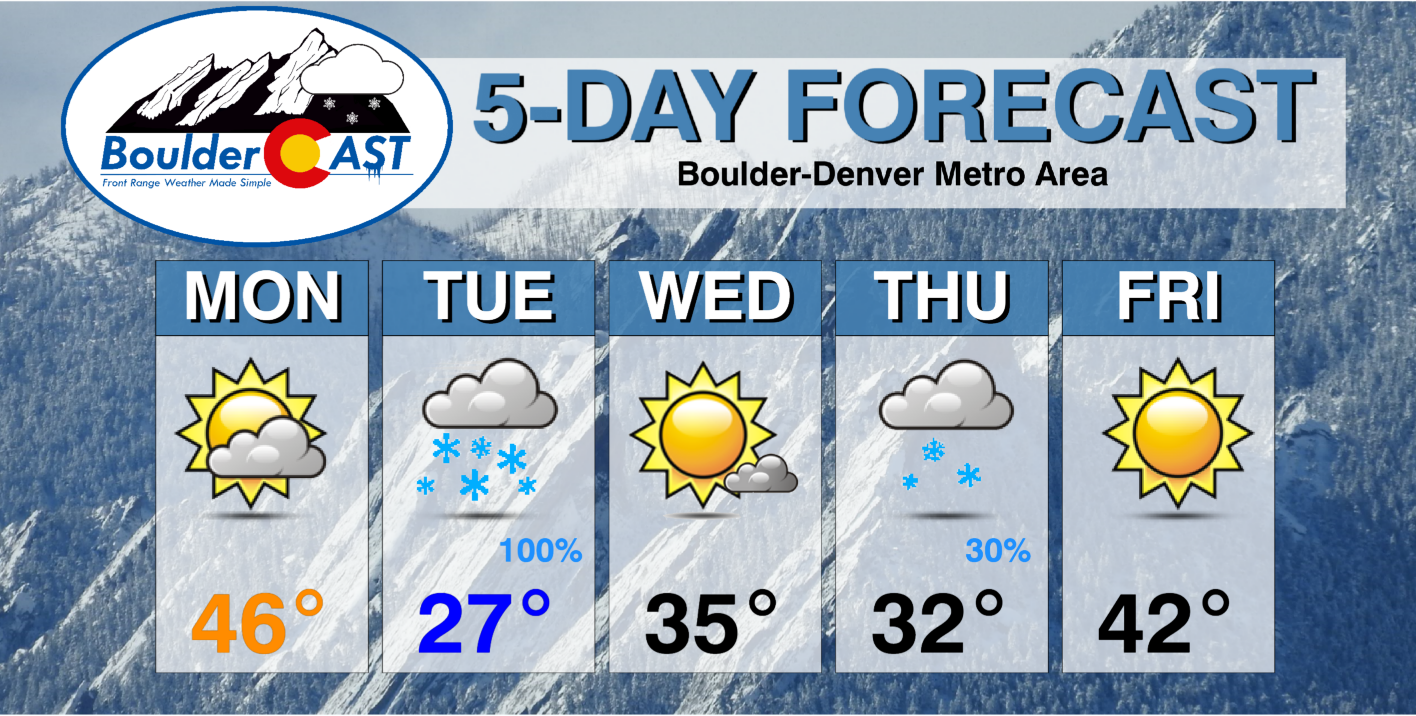
This week’s highlights include:
- A beautiful Monday with highs in the 40’s
- A quick-moving low pressure will impact the area on Tuesday bringing a burst of heavy snow in the morning
- Generally 2 to 6″ of accumulation is expected Tuesday with a slick morning commute and highs below freezing, highest totals west and southwest
- Another round of lighter snow may impact the area on Thursday, but that is still uncertain
- The week ends like it began: quiet and sunny with temperatures returning to the 40’s on Friday
DISCLAIMER: This weekly outlook forecast is created Monday morning and covers the entire upcoming week. Accuracy will decrease as the week progresses as this post is NOT updated. To receive daily updated forecasts from our team, among many other perks, subscribe to BoulderCAST Premium.

Heavy snow & difficult travel early Tuesday
We begin the week with an immediate Front Range snow event which is already taking shape some 1000 miles to our northwest. A trough of low pressure is set to dive southward out of British Columbia today and into the Four Corners area by Tuesday evening. In the process, this will bring a round of snowfall to our area as upslope ensues. As of Monday morning, the storm is still north of the border in Canada. Some of the lift from this system is spawning clouds and snowfall across northern Montana and Idaho already, seen as the green shadings in the infrared satellite animation below.
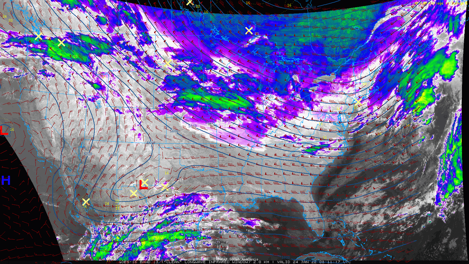
GOES-16 infrared satellite animation from early Monday morning. Note the system dropping into Montana from the north.
Forecast models remain in good agreement that this system will quickly dive southward and form a cut-off low pressure just east of the Four Corners by Tuesday evening. As this happens, a period of upslope and large-scale lift will team up across the Front Range spawning widespread snow for the area. Watch the system dive southward and develop into a closed low in the NAM 500mb vorticity forecast animation below.
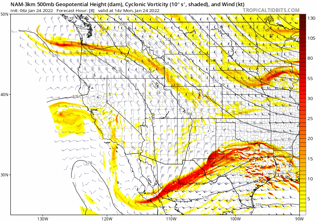
NAM-NEST 500mb height and vorticity forecast animation for Monday into Wednesday morning showing the evolution of the storm
The cold front will move southward and through the Denver Metro area early Tuesday morning several hours before sunrise.
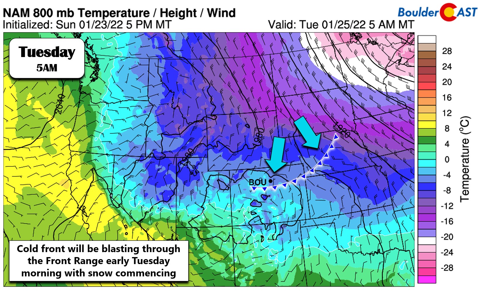
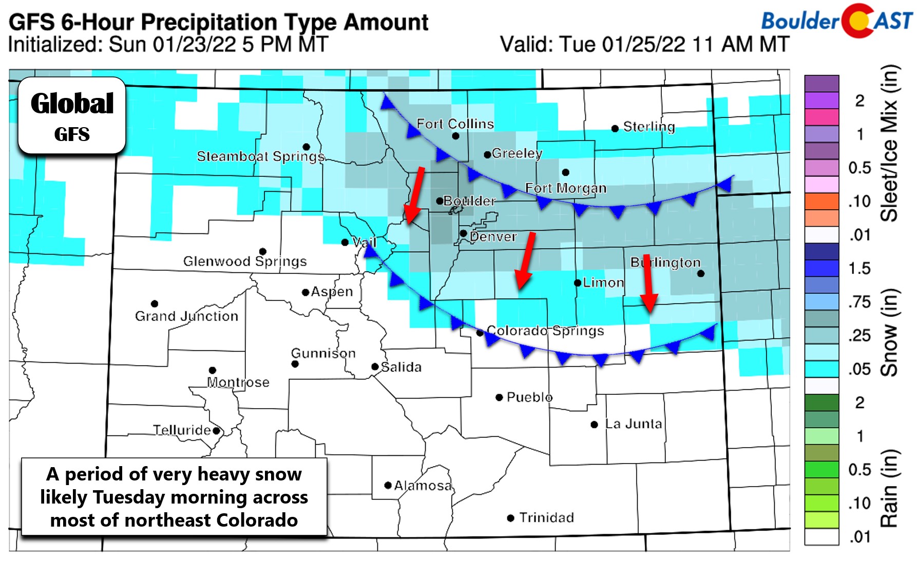
This cold front will offer up the most impactful weather for this event — a brief window of banded snowfall along the front as it moves through. The potential for a quick hit of heavy snowfall is showing up nicely in both the global and regional models — something that increases our confidence substantially in this outcome. Here’s a look at the GFS precipitation type forecast for Tuesday morning as the front drops through. As much as 1/2″ of liquid is forecast to fall in and near the Foothills Tuesday morning by this model — that is very heavy snow!
A closer, high-resolution look from the HRRR model shows a similar outcome. Snowfall rates with this frontal band will be around 1 to 2″ per hour.
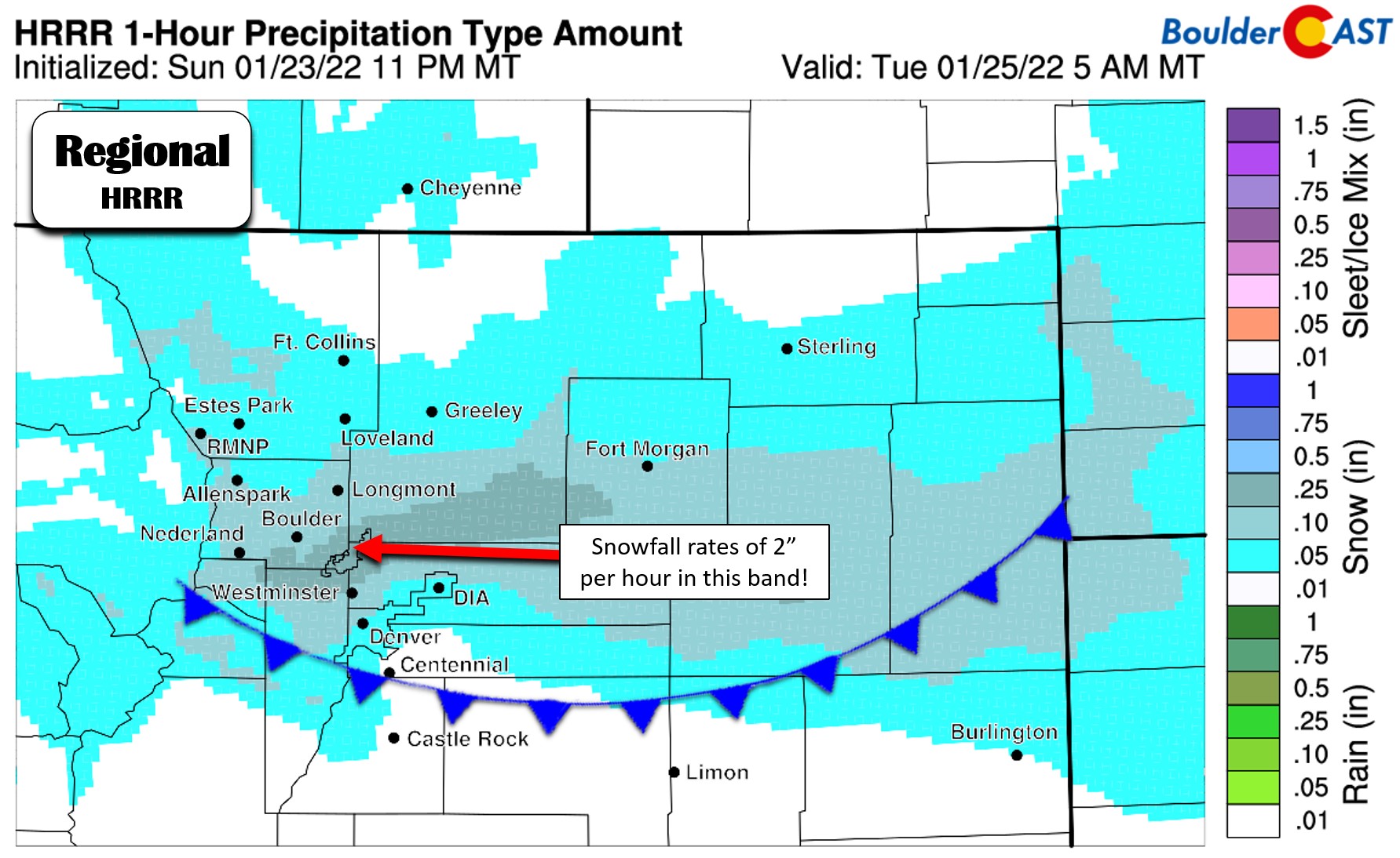
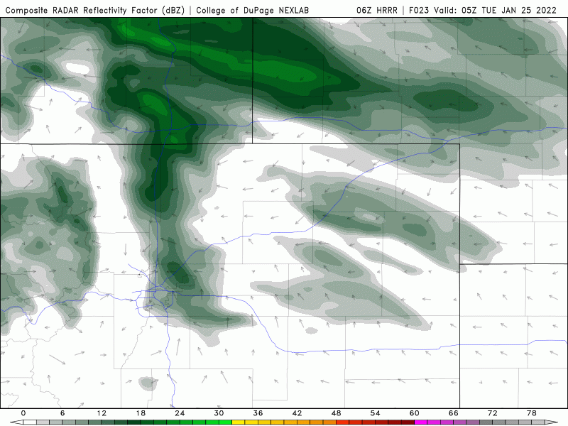
An animation of the latest HRRR simulated radar forecast is shown below. The banded snowfall early Tuesday is certainly impressive! The timing from this particular model brings heavy snow into the Boulder and Denver area around 5:00AM Tuesday with the worst of the snow likely ending by mid-morning. Global models are a couple hours slower. This several hour difference results in either a widespread snow-packed commute from heavy snow that has mostly already fallen, or an even more dangerous commute with heavy snow actively falling and limited visibility smack in the middle of the commute window. Either way, plan for slow and treacherous travel early Tuesday!
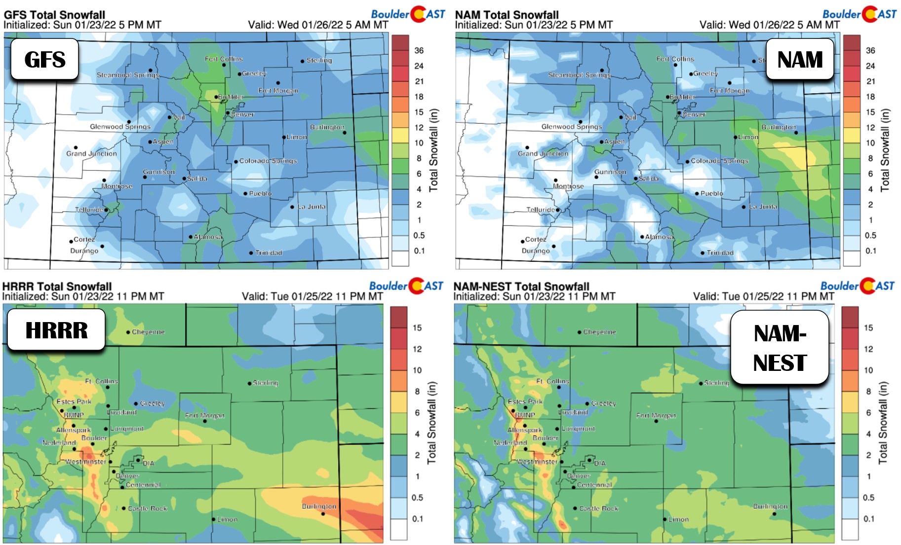
As far as snowfall amounts, we’re looking at several inches for the entire area as the band of heavy snow accompanying the front will not discriminate towards the terrain much. Only in the post-frontal regime from late morning into the afternoon will we see upslope start to favor locations in and near the Foothills. Here’s a look at four different model snowfall forecasts for the storm using our in-house snow ratio algorithm. You can see that several models have a bullseye of 5 to 9″ in the lower Foothills southwest of Boulder. However, across the Denver area, 2 to 6″ will be more common. It’s also important to note that a band of more substantial snow, perhaps dumping 6 to 12″, will probably develop out along the Kansas border during the day Tuesday. That’s not really in our domain, but good luck to the meteorologists trying to pinpoint that one!
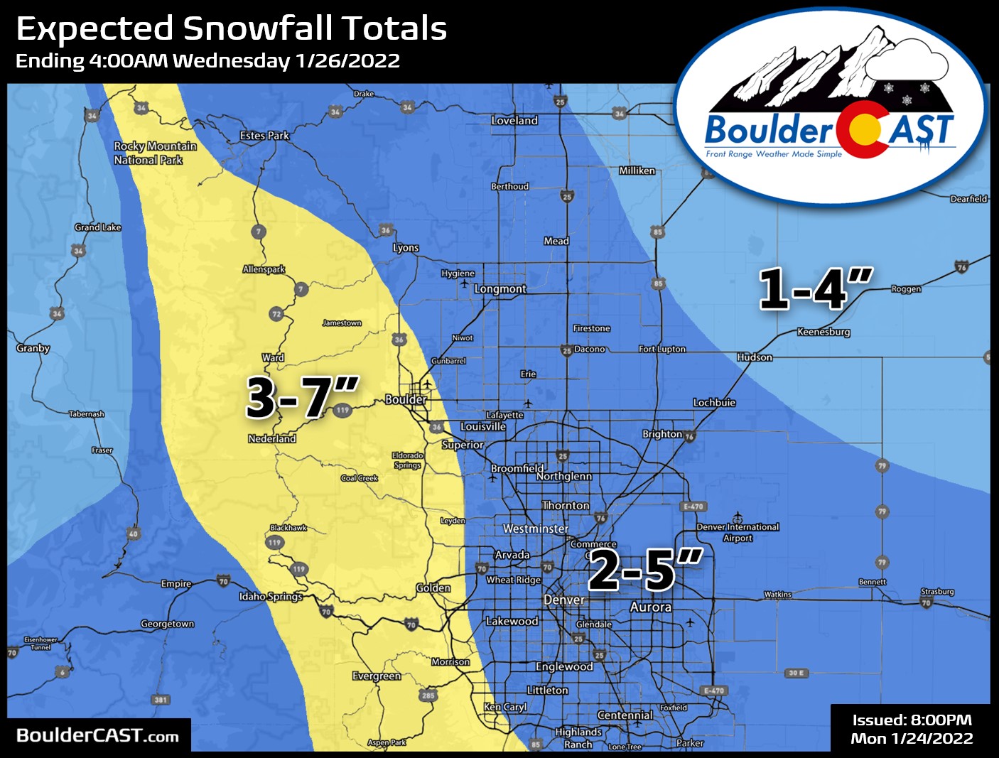
Given the model support for this event and the relative certainty that a period of heavy snow will occur Tuesday morning, this is a somewhat “easy” forecast for the area. Our snowfall forecast map for the event is shown below. Basically, we anticipate a broad brush of 2-5″ across the Denver area, with 3-7″ in Boulder and the Foothills. Lower totals are expected towards Greeley.
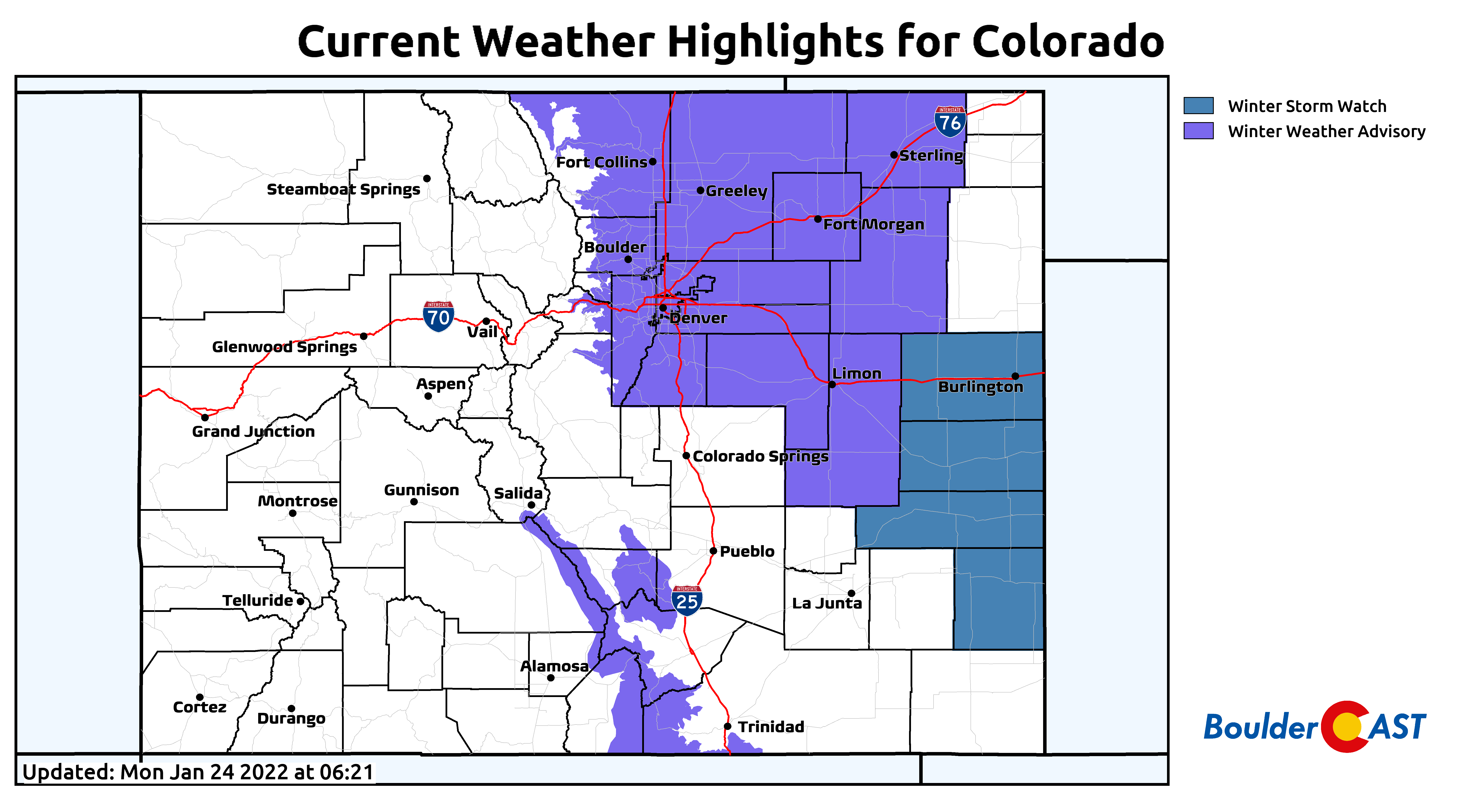
Winter Weather Advisories have already been issued for the entire Front Range area due to the high confidence of travel impacts Tuesday morning. Winter Storm Watches are posted along the Kansas border for reasons we already touched on.
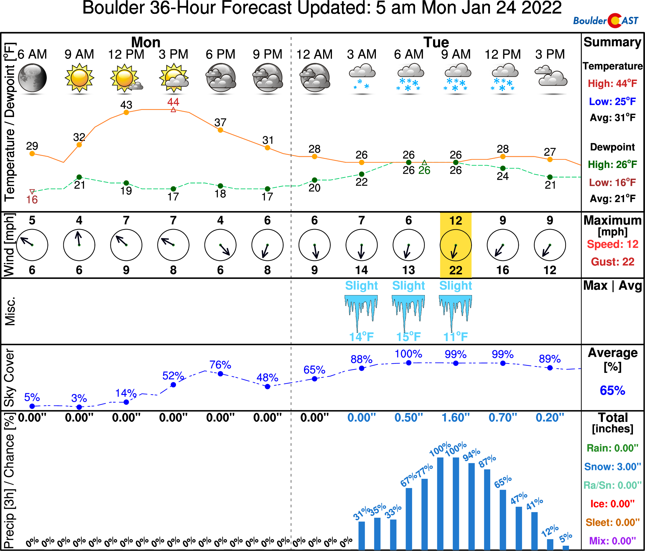
Light snow will continue in and near the Foothills with weak upslope persisting into the afternoon hours Tuesday before fully ending by evening. The timeline through the day Monday into midday Tuesday is shown below. Expect a fairly seasonal day Monday with highs in the mid to upper 40’s and some sunshine. Things go downhill rapidly before sunrise Tuesday, though! Temperatures will not make it out of the 20’s on Tuesday with overcast skies and light snow persisting in spots.
Calmer Wednesday & beyond, but not entirely
As we move into Wednesday, things will turn calmer across Colorado with a shortwave ridge moving overhead. Look for sunshine and highs in the 30’s to near 40 degrees.
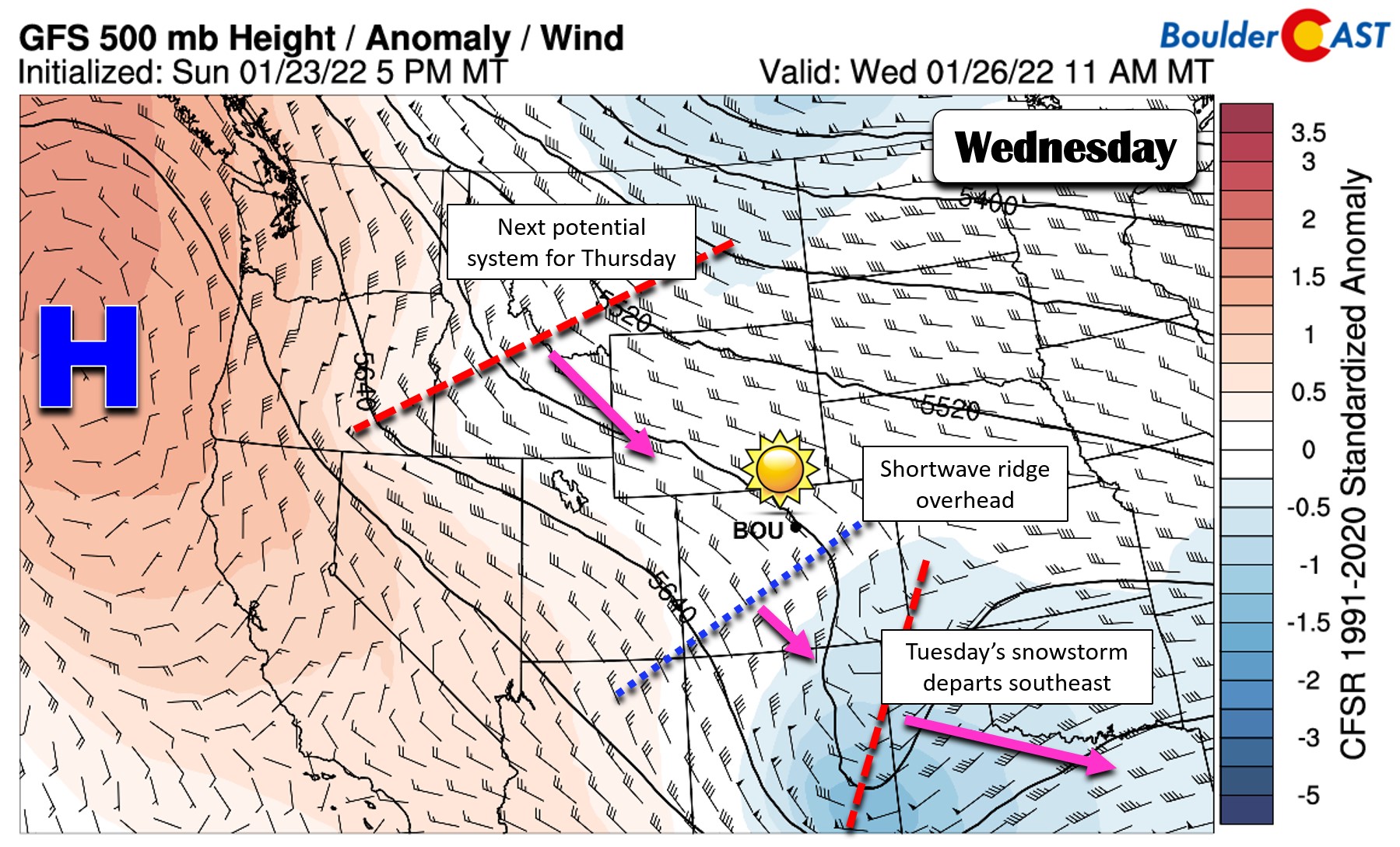
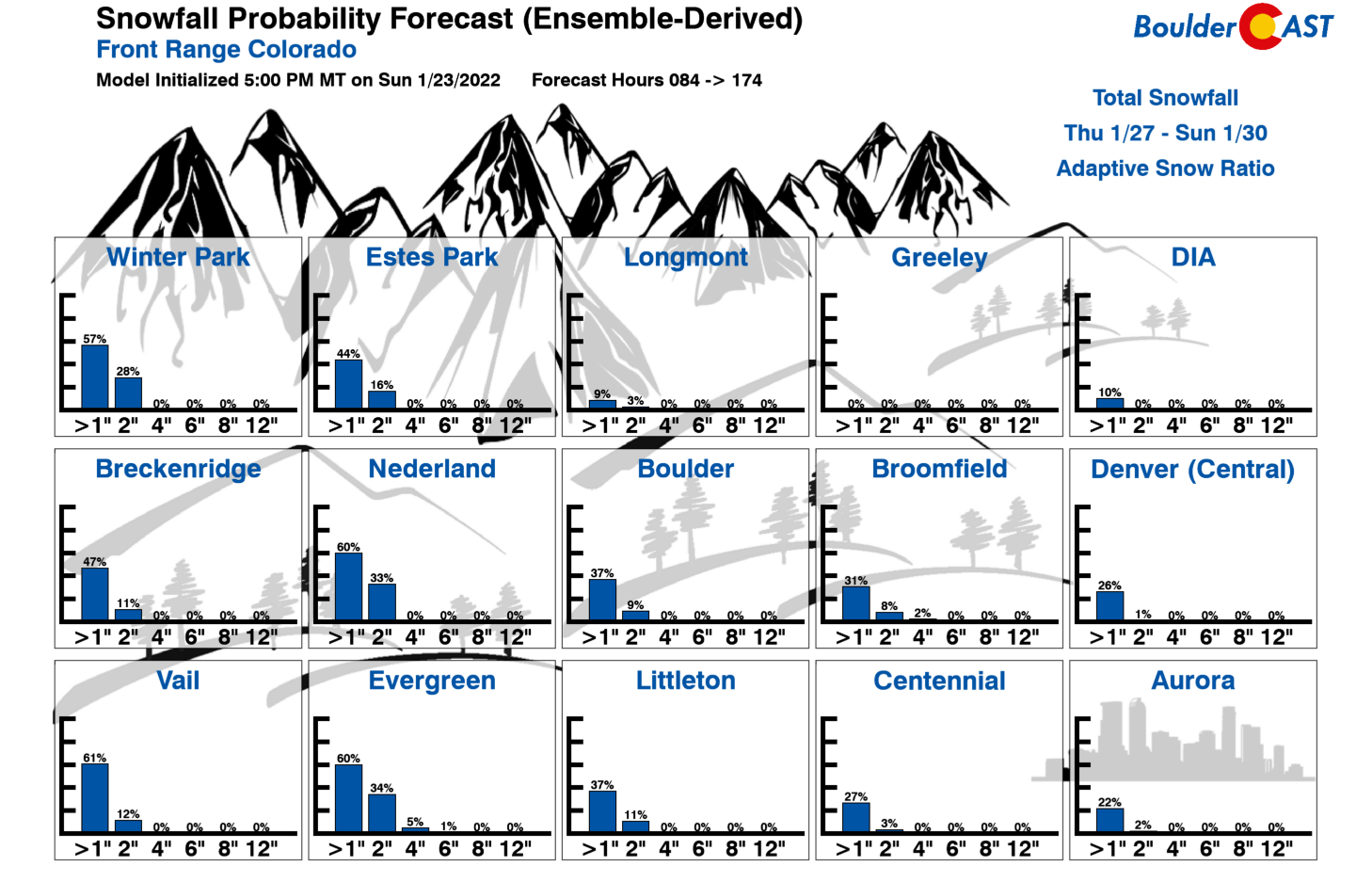
Not far off, though, will be another trough to the northwest which will sweep across Colorado on Thursday. Even though it has a similar appearance to the Tuesday system on paper, the late-week storm will come through weaker with less moisture to work with. Models don’t yet agree on how impactful this system will be for us, with the GFS dumping up to a couple inches of additional snowfall across the area, but the Euro is notably drier for the Front Range with minimal upslope. Our snowfall probabilities look meager with this second wave of snow — the most likely outcome is a dusting to 1″ in some spots. We’ll keep an eye on this second system, but plan on a cooler Thursday with a chance of light snow in the morning and afternoon timeframe.
The week ends on a very quiet note with yet another ridge moving across the area. Friday will be warmer and quite sunny with temperatures in the 40’s.
Let’s hope both snow events pan out this week — we certainly need it!
Stay up to date with Colorado weather and get notified of our latest forecasts and storm updates:
Forecast Specifics:
Monday: Sunshine early in the day, but clouds increase in the afternoon. Highs seasonal in the mid to upper 40’s across the Plains with lower 30’s in the Foothills.
Tuesday: Sharply colder and overcast with heavy snow likely in the morning followed by light snow lingering in the afternoon. Highs in the middle to upper 20’s only across the Plains with teens in the Foothills. Several inches of accumulation are likely with a treacherous commute in the morning.
Wednesday: A bitter cold morning followed by a mostly sunny day. Highs reach only into the 30’s across the Plains with 20’s in the Foothills.
Thursday: Mostly cloudy with a chance of light snow in the morning and afternoon. Some late-day sunshine is possible. Expect light accumulations at worst with this system. High temperatures in the 30’s across the Plains with 20’s in the Foothills.
Friday: Quiet and mild to end the week with lots of sun. Temperatures top out in the 40’s across the Plains with 30’s in the Foothills.
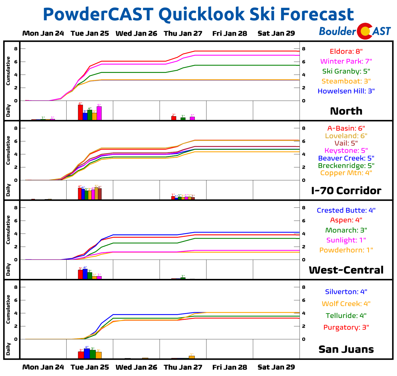
Mountains: The main storm of the week for the Mountains will be Monday night into Tuesday for the northern and central Mountains with 3-8″ of new snow expected. This system drops into southern Colorado bringing light accumulations for the San Juans Tuesday afternoon through Tuesday night. Another storm will likely bring light accumulations on Thursday before drier weather takes over Friday into the weekend.
Help support our team of Front Range weather bloggers by joining BoulderCAST Premium. We talk Boulder and Denver weather every single day. Sign up now to get access to our daily forecast discussions each morning, complete six-day skiing and hiking forecasts powered by machine learning, first-class access to all our Colorado-centric high-resolution weather graphics, bonus storm updates and much more! Or not, we just appreciate your readership!
Spread the word, share the BoulderCAST forecast!


You must be logged in to post a comment.