After weeks of spring-like warmth and quiet skies, the atmosphere is finally showing signs of waking up in the West. While drought continues to tighten its grip and Colorado’s snowpack sits at historic lows, things are beginning to stir, subtly at first, but with hints of something more promising on the horizon. This week brings our warmest day yet with Monday approaching 70 degrees, then a quick cooldown Tuesday, and finally the return of Mountain snow midweek courtesy of a weak atmospheric river. It’s not the pattern shift we need just yet, but it’s the most active stretch we’ve seen in a while… and it may be the first step toward rebuilding what winter has failed to deliver so far in the High Country. Let’s dig in.
This week’s highlights include:
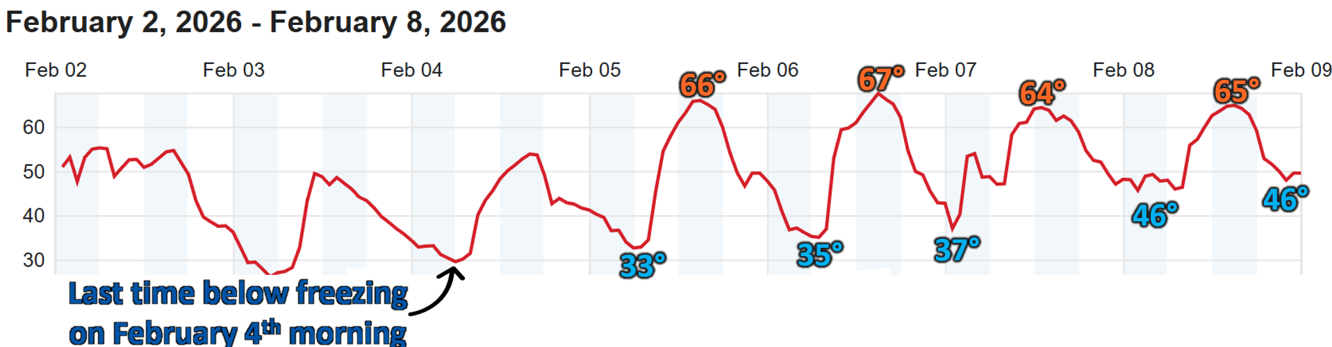
- 🌤️ Warm, Quiet Front Range Stretch: Highs have been in the 60s since Thursday with no below freezing temps since last Wednesday.
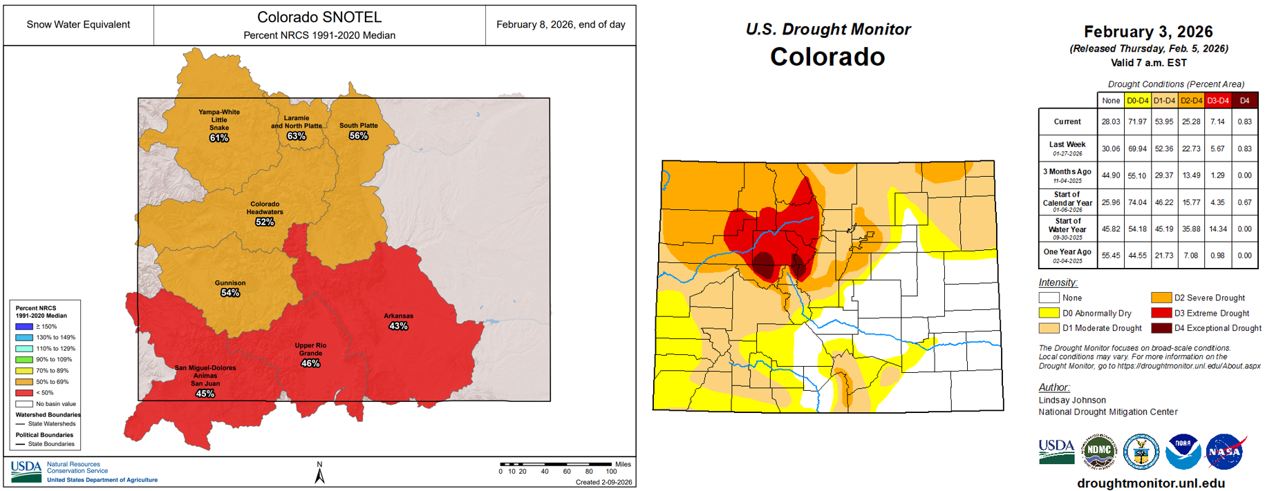
- 🌵 Drought & Snowpack Concerns: Moderate to Severe Drought grips the Front Range as statewide snowpack lingers at historically low levels.
- 💨 Monday’s Warmth & Winds: Highs near 70°. Some areas will see gusts over 30 MPH and Red Flag Warnings near the Wyoming border.
- 🌡️ Cooler But Still Mild Midweek: A dry front knocks temps back to the 50s Tuesday, followed by a cloudier, moisture‑laden pattern.
- ❄️ Weak Atmospheric River for the Mountains: A moisture plume brings 6 to 12″+ of high‑elevation snow (locally 18″+) Wednesday morning into Thursday night, offering a much‑needed snowpack boost.
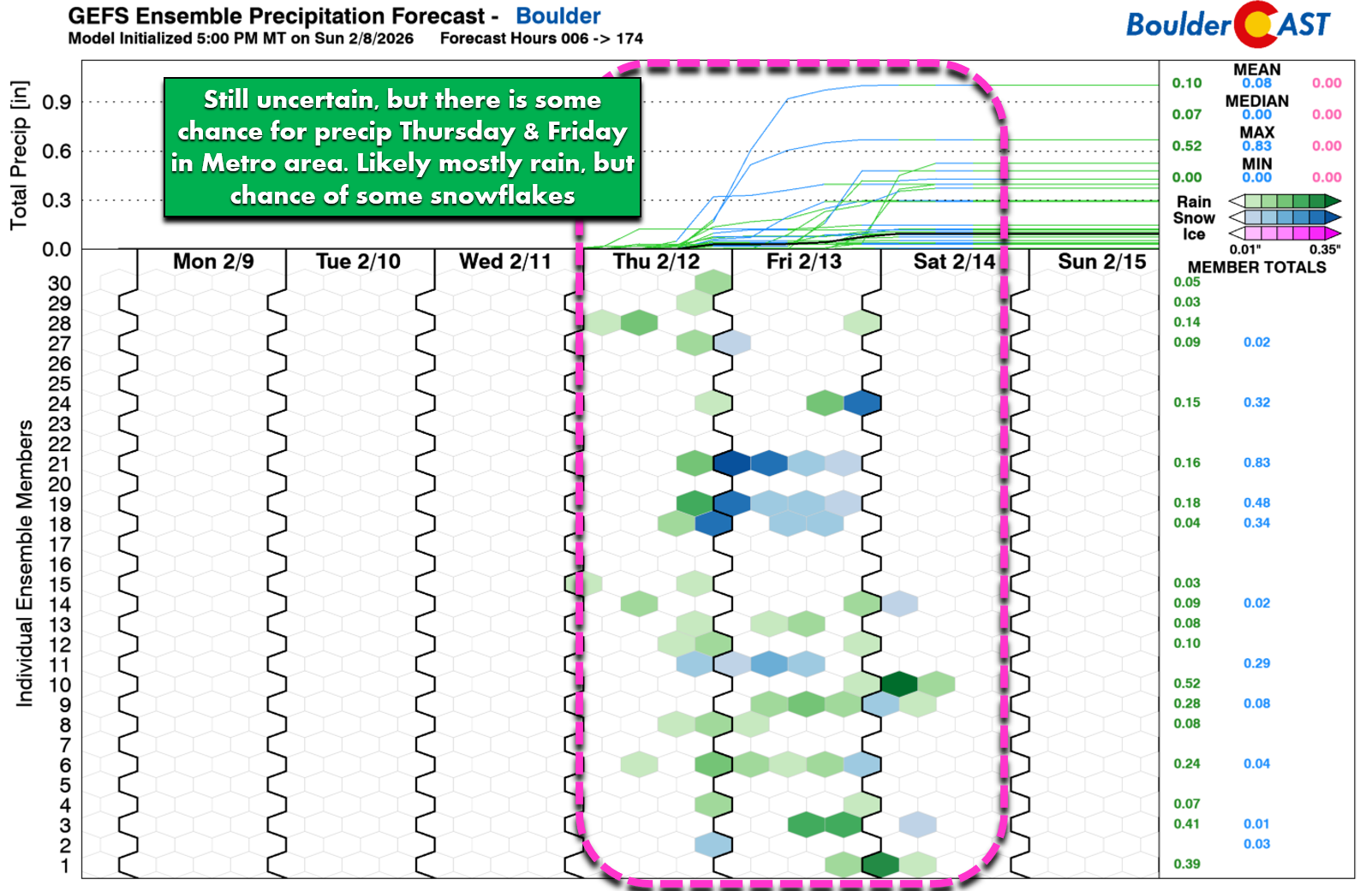
- 🌦️ Light Showers Possible on the Plains: Limited moisture will reach east of the Divide but the Metro area will see a chance of precipitation Thursday and Friday, mainly in the form of rain.
- 🏔️ More Mountain Snow Next Week? Another atmospheric river next week hints at a more active, snow‑friendly pattern continuing across the West.
- 🔥 No Relief for Denver or Boulder: We’re not expecting much moisture to make it east of the Divide over the next two weeks, with potentially windy conditions next week spiking fire danger for several days.
DISCLAIMER: This weekly outlook forecast is created Monday morning and covers the entire upcoming week. Accuracy will decrease as the week progresses as this post is NOT updated. To receive daily updated forecasts from our team, among many other perks, subscribe to BoulderCAST Premium.

Go Premium, get all the perks.
Daily Forecast Updates
Get our daily forecast discussion every morning delivered to your inbox.
All Our Model Data
Access to all our Colorado-centric high-resolution weather model graphics. Seriously — every one!
Ski & Hiking Forecasts
6-day forecasts for all the Colorado ski resorts, plus more than 120 hiking trails, including every 14er.
Smoke Forecasts
Wildfire smoke concentration predictions up to 72 hours into the future.
Exclusive Content
Weekend outlooks every Thursday, bonus storm updates, historical data and much more!
No Advertisements
Enjoy ad-free viewing on the entire site.
A More Active Week as Mountain Snow Returns
The Front Range has been basking in undeniably pleasant weather of late—warm afternoons, quiet winds, and a remarkable lack of freezing temperatures. Our station hasn’t dipped below 32°F since last Wednesday, a testament to just how gentle “winter” has been of late.
Of course, that same tranquility is also the problem. Aside from a couple of brief cold snaps, this season has lacked any real winter punch. Moderate to Severe Drought now blankets the entire Front Range, and statewide snowpack remains at historic lows for early February. Many basins are running at 50-60% of normal, and the southern basins are faring even worse. It’s a sobering backdrop, but not a hopeless one. This week’s weather pattern is finally showing signs of life with a return of the white stuff in the Mountains.
The week ahead will be more active than anything Colorado has seen in quite some time, though it still won’t deliver the wholesale pattern flip we desperately need. Ensemble guidance keeps a ridge loosely draped over the central Rockies through Thursday, but it’s weaker and more variable than the dominant block we’ve been stuck under of late. By late week, a Pacific trough pushes ashore and slides toward the southern Rockies, nudging us into a more unsettled regime.
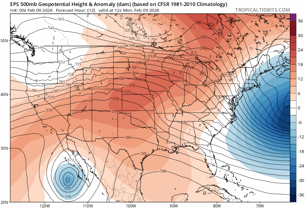
European ensemble 500mb height anomaly forecast animation for the week
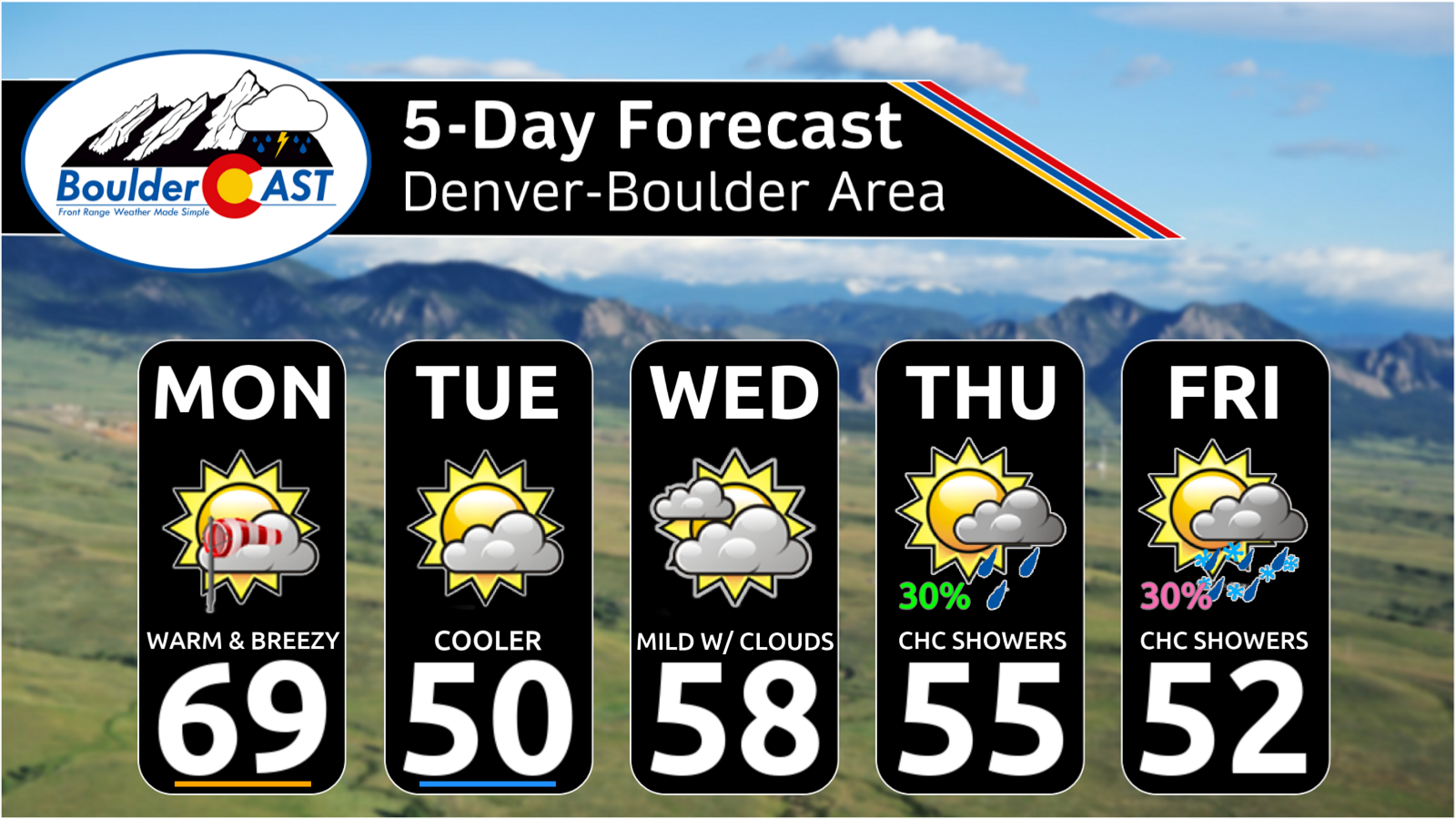
Monday: One Final Very Warm Day
Monday will be exceptionally mild—likely the warmest day of this ongoing warm spell. A weak disturbance passing through Wyoming and Montana will tighten the westerly flow aloft, boosting winds across portions of the Metro area.
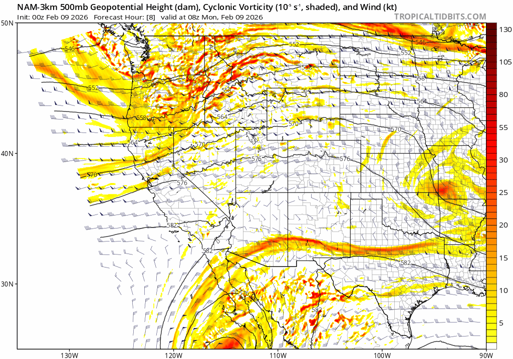
High-resolution 500mb vorticity forecast for Monday into Monday night showing the northern stream wave passing across Wyoming/Montana
Short‑range guidance shows classic “Foothills wind tongues” pushing eastward during the day, with favored spots seeing gusts over 25 to 35 MPH.
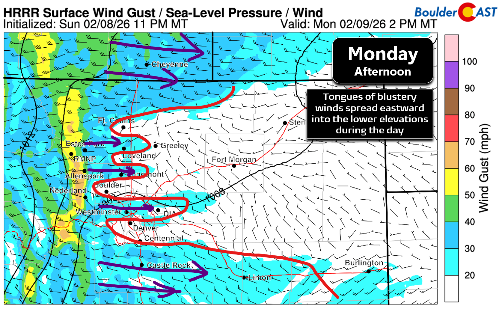
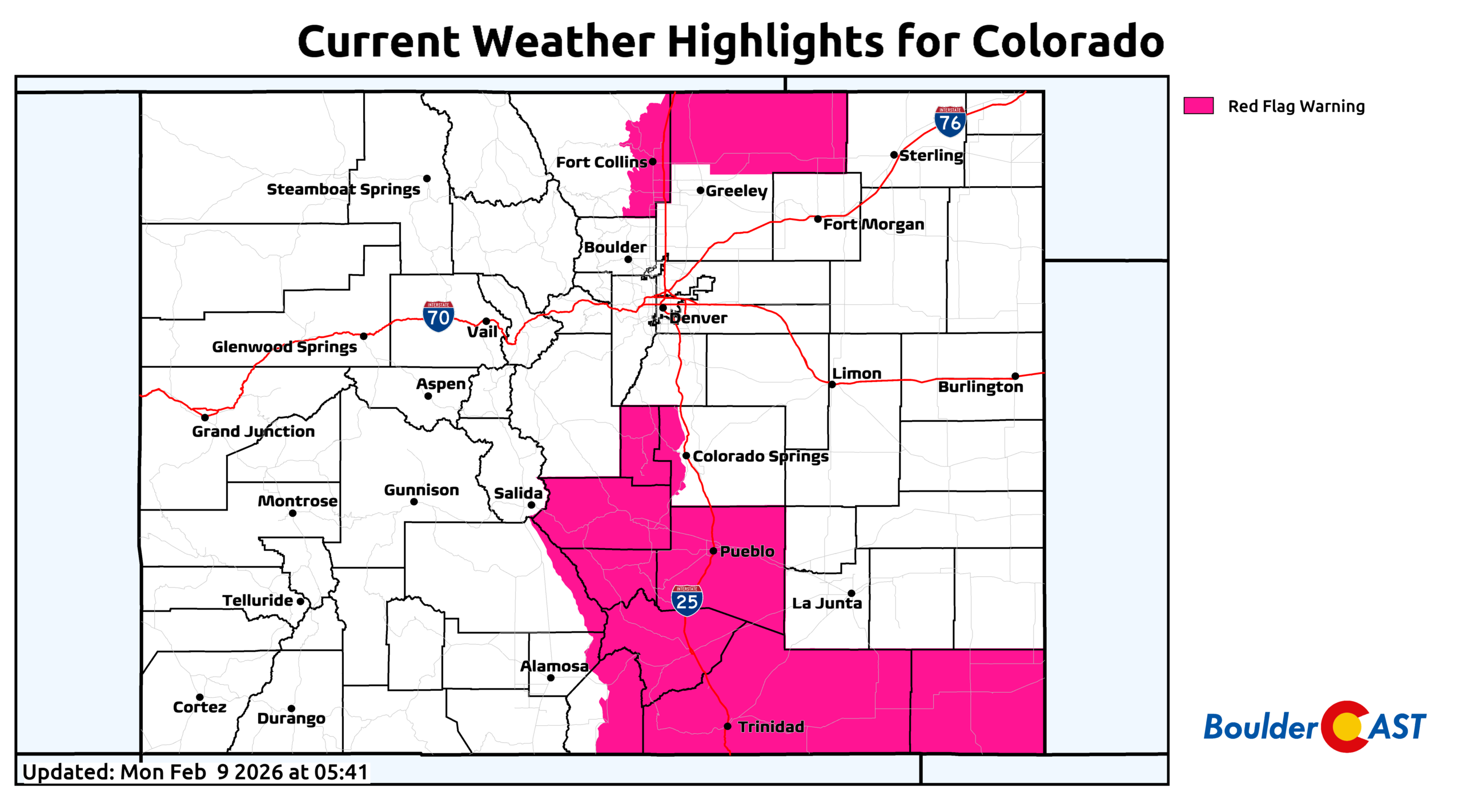
The strongest, most persistent winds will be along the Wyoming border north of Fort Collins, where Red Flag Warnings are posted from 11 AM to 5 PM.
For Denver and Boulder, expect a breezy, partly cloudy day with highs around 70°, roughly 20° above normal, though still shy of Boulder’s 78° record high for February 9th (1954).
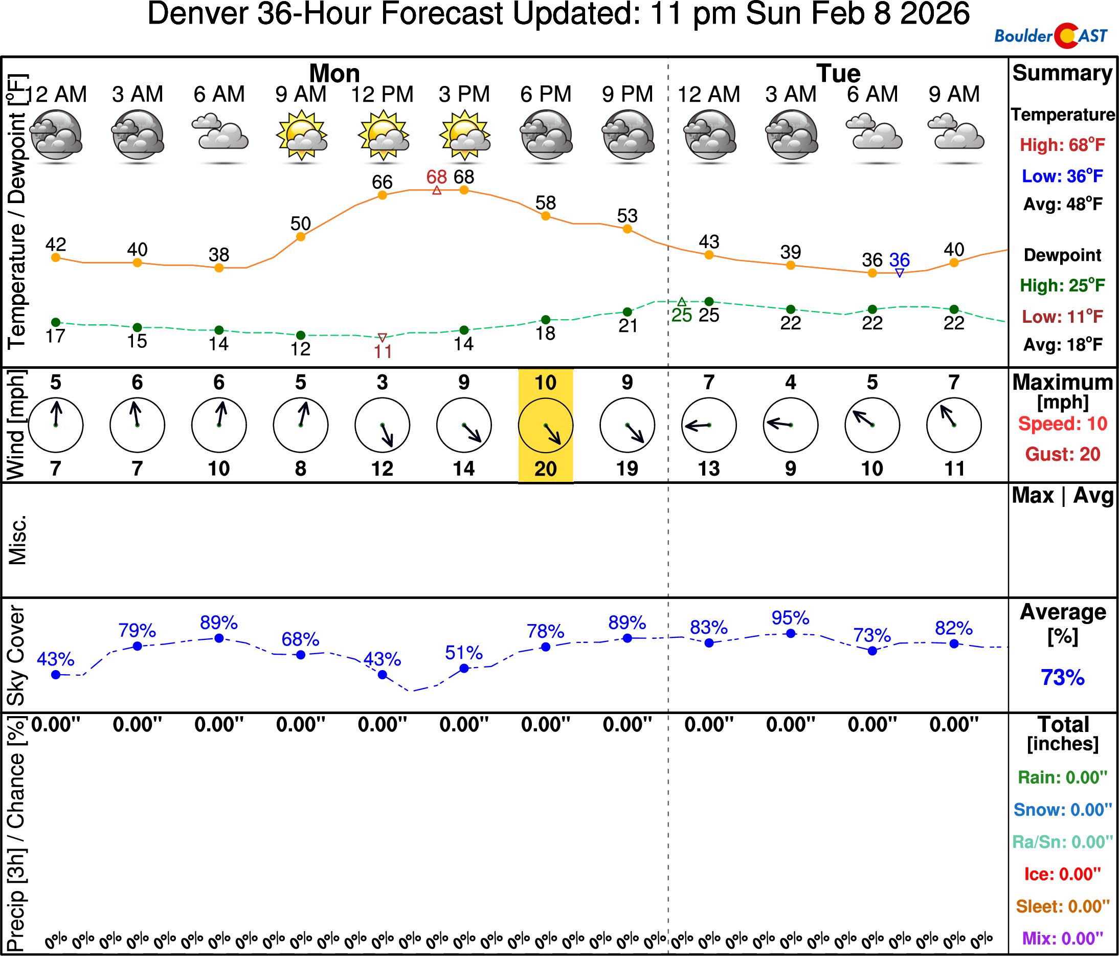
A dry cold front arrives Monday evening, tied to the northern‑stream wave. Aside from a brief bump in winds, it brings no precipitation. It will, however, end our anomalously warm run, with Tuesday’s highs sliding back into the lower 50s—much closer to seasonal norms.
Midweek: A Weak Atmospheric River Brings Mountain Snow
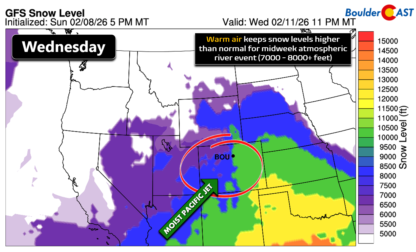
Early Wednesday, a Pacific storm digs toward California and stalls, allowing the subtropical jet to arc into the Four Corners. This setup taps into a weak atmospheric river, sending a 48‑hour plume of moisture into Colorado from the southwest.
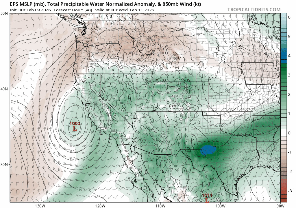
Rain and snow will break out across western Colorado early Wednesday and become widespread through the day. Warm southwest flow keeps snow levels high—generally above 7,500 feet, and possibly above 8,500 feet in the San Juans. Not ideal for snowpack building, but at this point any moisture is welcome. Snow levels lower slightly Thursday, though not dramatically. Expect valley rain and snow confined to passes and peaks.
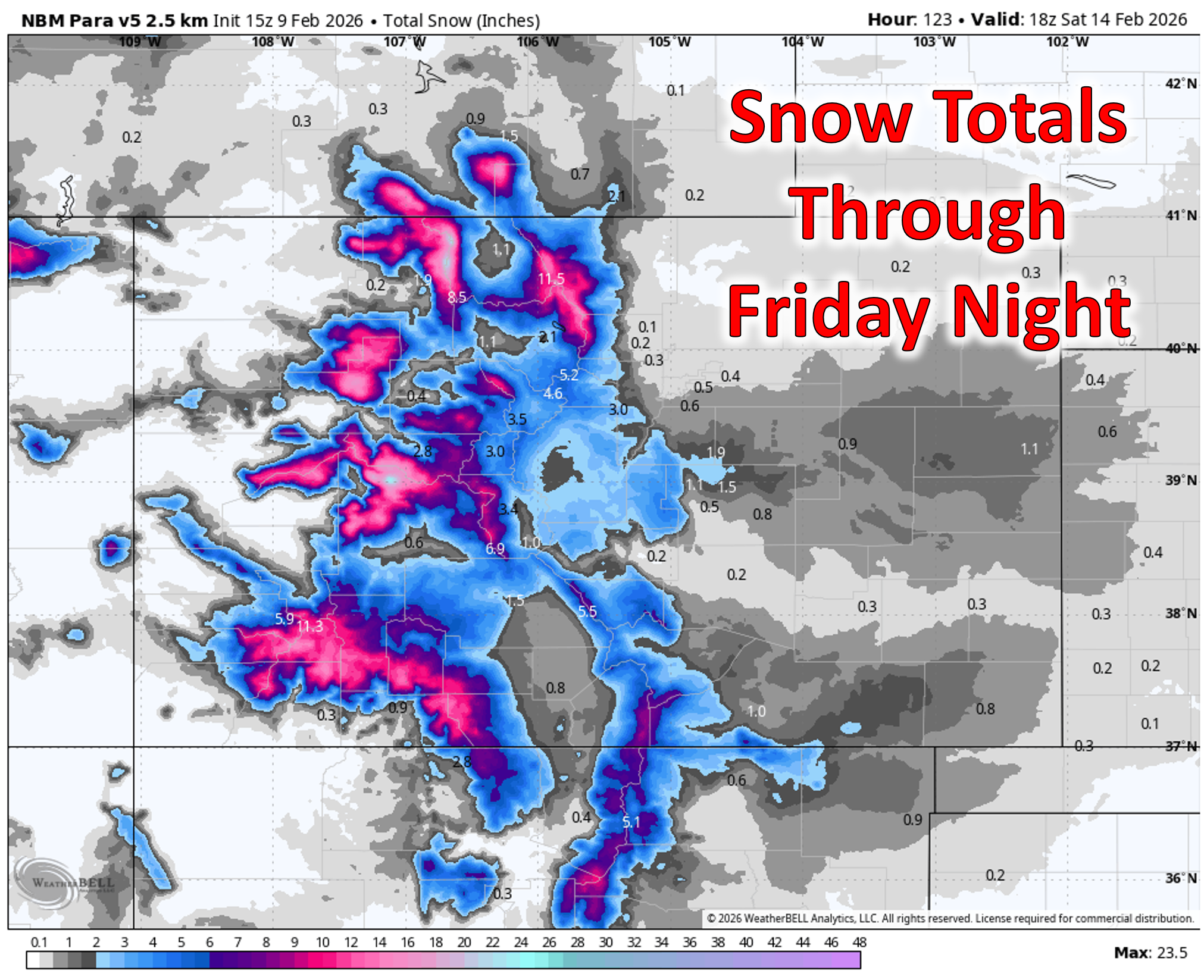
Most ski areas should net 6 to 12 inches, with favored high‑elevation resorts—like Steamboat, Aspen, maybe Vail—pushing 18 inches or more. After such a dismal season, this is a meaningful step in the right direction.
Lower Elevations: Limited Moisture, Mostly Rain
East of the Divide, the outcome of the atmospheric river is murkier. Model spread remains large regarding the trough’s eventual evolution late week. It’s pretty clear that moisture transport over the Continental Divide will be limited, but a few light showers are possible Thursday (rain) or Friday (rain/snow mix). With warm boundary‑layer temperatures, the odds favor February rain over snow for Boulder and Denver. Any precipitation looks light—generally under 0.15″ of liquid.
After our very warm Monday and cooldown Tuesday, temperatures Wednesday through Friday hold in the 50s thanks to the warm, moist southwest flow and increased cloud cover. Precipitation chances, while there, will be nothing to write home about.
Weekend and Beyond: A More Active Pattern Emerging
By late Friday into Saturday, drier northwesterly flow returns, bringing more sunshine and highs in the 50s. Sunday could nudge back into the 60s.
But the real story is what comes next: another atmospheric river event is lining up for early to mid next week, again targeting the Four Corners and Colorado’s mountains.
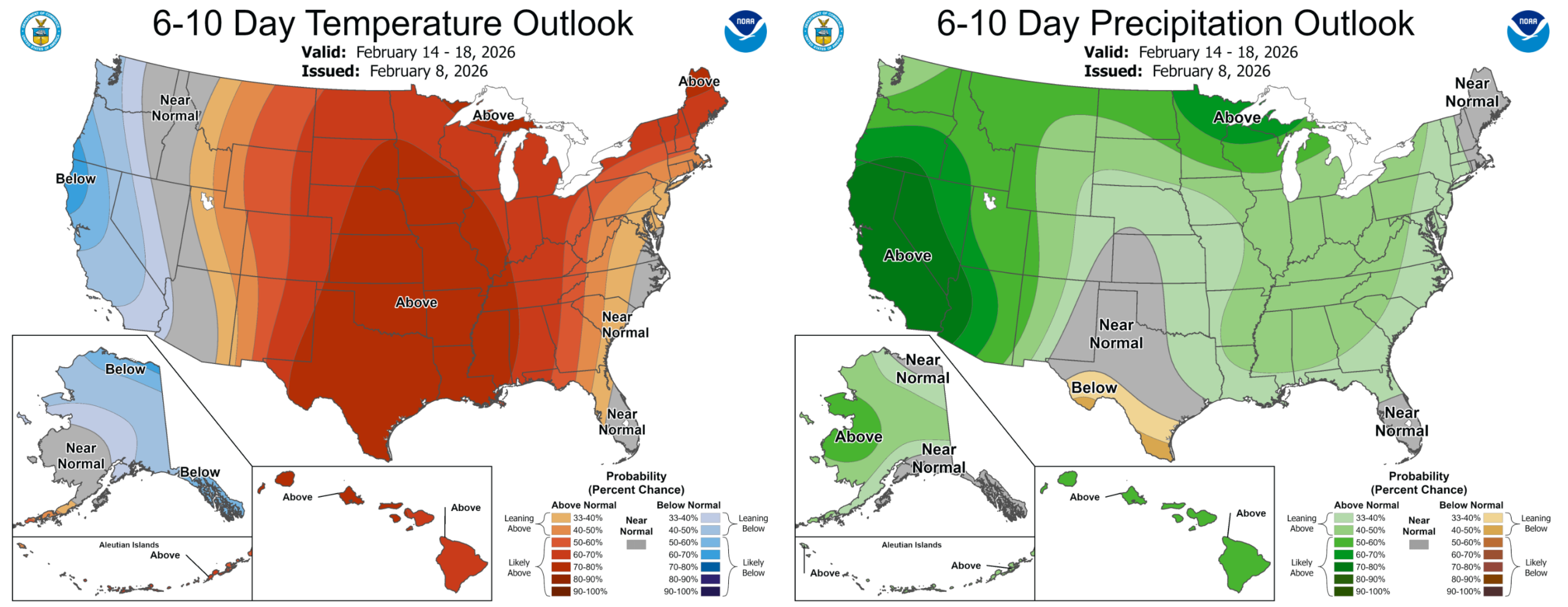
If it materializes, the High Country could see another healthy round of snow—exactly the kind of repeated moisture pulses we need to chip away at the snowpack deficit. This is GREAT news overall, but sadly it still doesn’t look like much moisture will make it east of the Mountains, with drought likely to persist and intensify further in the Boulder-Denver area. Next week’s pattern may also inject quite a bit of wind into our forecast which will bump up the fire danger.
It’s far too early to declare victory in terms of Mountain snow, but after months of stagnation, the atmosphere is finally showing signs of shifting toward a more productive southern storm track. For Colorado’s Mountains—and the broader West—that’s a trend worth rooting for. Happy Monday!
A picture of a pika from a recent hike, because who doesn’t love pikas?
Forecast Specifics:
Monday: Partly cloudy, very warm, and sporadically breezy. Gusts of 25 to 35 MPH possible in some areas. Highs reach near 70 degrees on the Plains with upper 50s in the Foothills.
Tuesday: Partly cloudy and cooler in the wake of a cold front. Highs more seasonal in the lower 50s for the Plains with lower 40s in the Foothills.
Wednesday: Partly to mostly cloudy and mild with highs in the upper 50s on the Plains and upper 40s in the Foothills. Snow returns to the Mountain peaks and passes, increasing through the day into the nighttime.
Thursday and Friday: Partly cloudy with a chance of light showers in the Metro area. Most of this would be rain, but some snow could mix in on Friday. Highs in the low to middle 50s on the Plains with upper 30s in the Foothills.
Weekend: Dry and quiet weather is expected for the weekend under northwest flow. Highs in the 50s Saturday but Sunday could be in the 60s.
DISCLAIMER: This weekly outlook forecast is created Monday morning and covers the entire upcoming week. Accuracy will decrease as the week progresses as this post is NOT updated. To receive daily updated forecasts from our team, among many other perks, subscribe to BoulderCAST Premium.
Go Premium, get all the perks.
Daily Forecast Updates
Get our daily forecast discussion every morning delivered to your inbox.
All Our Model Data
Access to all our Colorado-centric high-resolution weather model graphics. Seriously — every one!
Ski & Hiking Forecasts
6-day forecasts for all the Colorado ski resorts, plus more than 120 hiking trails, including every 14er.
Smoke Forecasts
Wildfire smoke concentration predictions up to 72 hours into the future.
Exclusive Content
Weekend outlooks every Thursday, bonus storm updates, historical data and much more!
No Advertisements
Enjoy ad-free viewing on the entire site.
Enjoy our content? Give it a share!


Leave a Reply
You must be logged in to post a comment.