
A continued flow of weak weather systems into Colorado this week will lead to a duet of light snow chances and unseasonably cold temperatures through mid-week. However, things take a much warmer turn heading into the weekend.
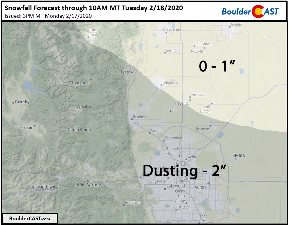
Update (Mon 2/17/20 3:00 PM): Added our official snowfall forecast map for light snow falling Monday evening and night.
An active early week, but only light snow expected
Happy “holiday” Monday. Whether you’re celebrating Presidents Day on vacation or at work, we’ve got you covered for the weather this week! A look at the water vapor animation this morning from the GOES-East weather satellite shows a broad and relatively deamplified trough across the continental United States. Notice the southward push of air into the Pacific Northwest, the west to east (zonal) flow across most of the country, and the moist northward stream along the East Coast. These features outline the base of this large-scale trough. The storm track into Colorado will be active for the first half of the week, but the end result won’t be terribly snowy across the Front Range, at least as things appear now. It sure will be cold, however.
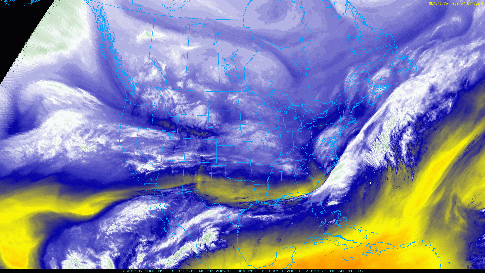
GOES-East mid-level water vapor animation from Monday morning across the CONUS
Over this past weekend, a moist Pacific jet brought significant snow to the mountains of northern and northwest Colorado, but only downslope to the Denver Metro area.
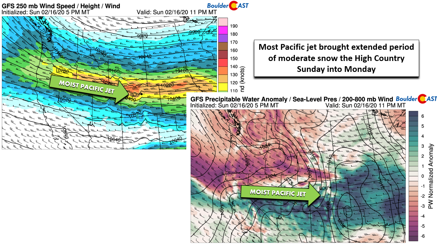
GFS 250 mb wind forecast map (left) and precipitable water anomaly map (right) for this past Sunday evening
A nice visualization of this moist jet can be seen in the animation of precipitable water anomaly below.
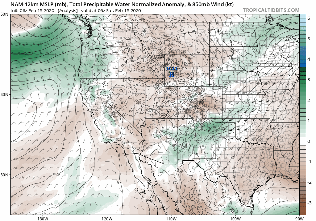
NAM precipitable water anomaly forecast animation from Saturday into Monday morning
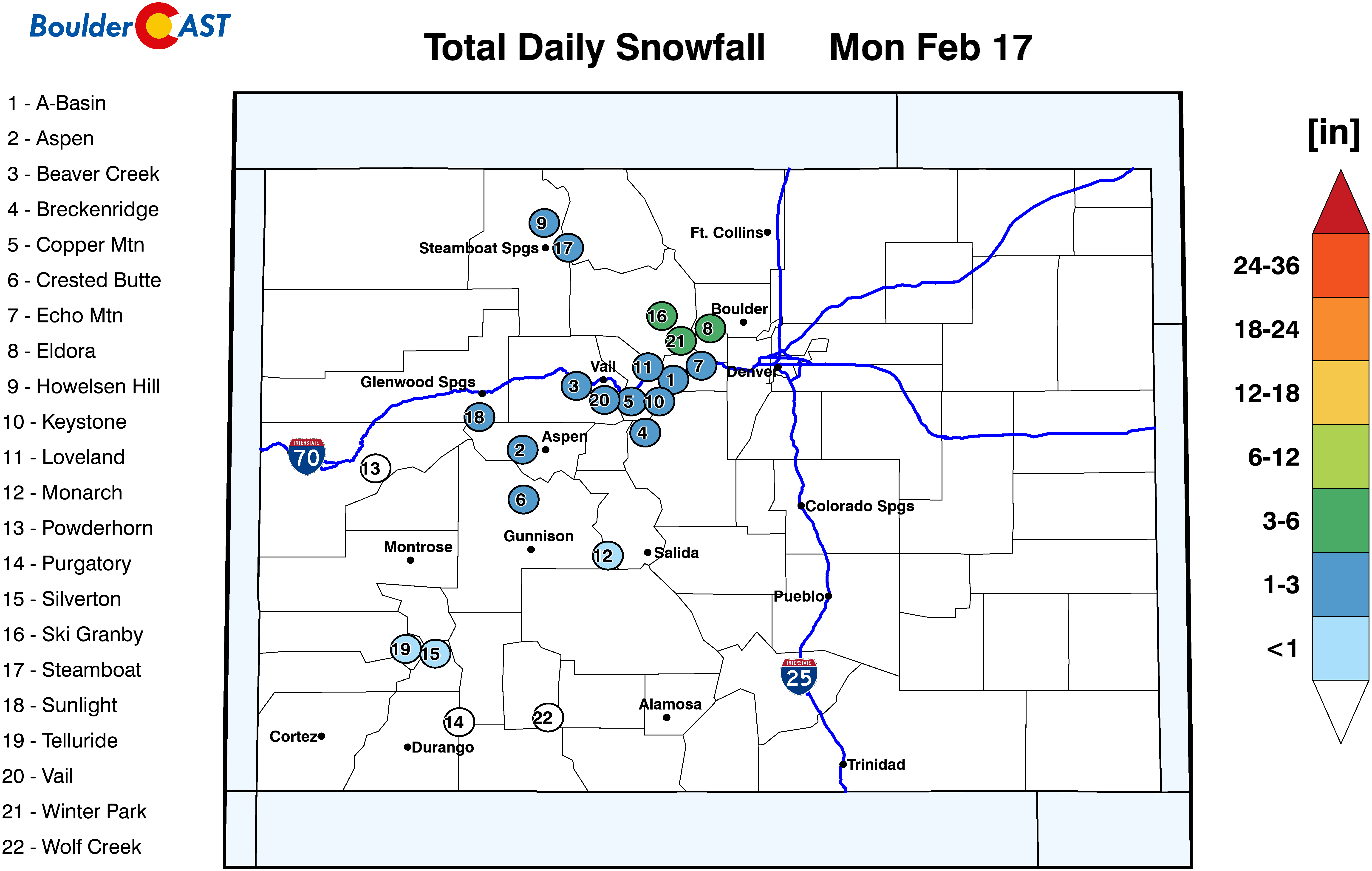
Fast west-northwest winds and copious moisture combined to produce the orographic snows in the Mountains the last few days. A handful of resorts received more than a foot of snow with this jet. Even Eldora, which is located east of the Continental Divide, picked up 10″ of “spill over” snowfall from this event, compliments of the very fast winds aloft. Here are the top snowfall totals from Saturday night into Monday morning from the resorts:
- Steamboat: 18″
- Winter Park: 16″
- Breckenridge: 15″
- Copper Mountain: 13″
- Eldora: 10″
As the jet continues to sag south and weaken Monday morning, snowfall will wind down in the Mountains quickly. With this, our attention shifts to an approaching weak shortwave disturbance behind the aforementioned jet (below on left). We’ve been monitoring this specific wave since the middle of last week, but it is coming in on the lower end of the intensity spectrum, just clipping across Colorado Monday evening and night. It doesn’t have a lot of moisture accompanying the weak lift. In particular, a layer of very dry air will be present in the lower atmosphere as it arrives. It will take a while for this layer to moisten up, but once it does, we do expect a period of light snow to break out across the Metro area late Monday evening into the overnight hours. Based on everything we are seeing, we’re only predicting a light dusting to 2″ of snow Monday night into early Tuesday. The highest totals are expected to be south of Interstate 70 into the Palmer Divide. Highs Monday will be near 40 degrees, dropping back into the 30’s for Tuesday.
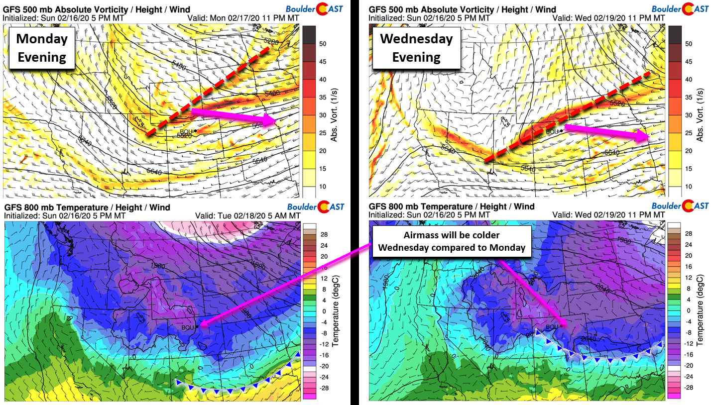
GFS 500 mb vorticity forecasts (top) and 800mb temperature forecasts (bottom) for Monday night (left) and Wednesday evening (right)
Our official snowfall forecast map for snow falling Monday night into the very early morning hours on Tuesday is shown below. Areas that reach closer to 2″ could see minor impacts on the Tuesday morning commute.
By Wednesday, the active weather pattern will deliver yet another shortwave disturbance to northern Colorado (above on the right). This one will be a little stronger and a tad further south. This more southern track will allow a deeper colder airmass to drop into the Front Range, but may also focus the best lift too far south of our region. The timing of the cold front will likely be sometime Wednesday morning with the best lift showing up during the afternoon into the evening hours. There could be a short period of freezing drizzle Wednesday morning before deeper cold air arrives to change things over to snow. In any case, we’re slightly more optimistic about the snowfall potential with Wednesday’s system. The upslope looks fairly good. It’s too far out to give a definitive projection, but it seems like models are trending towards a 1-3″ snowfall event for the Metro area. Expect very cold temperatures for mid-week…highs only in the 20’s.
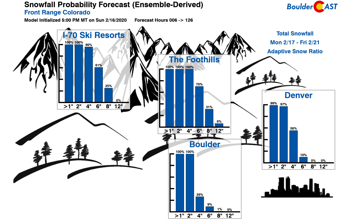
Thus, between the two wintry systems this week, Monday night and then on Wednesday, the Metro area could see anywhere from 1-5″ of snowfall combined. Our snowfall probabilities through the full week indicate this as well, with perhaps slightly better odds in Denver than Boulder.
A tamer late week and a warm-up
A less exciting atmospheric set-up appears to be gearing up for the tail-end of the week into the weekend as two different ridges come together across the Intermountain West, making for a single pronounced ridge of high pressure. This will lead to a quiet and much warmer end to the week for our area. Expect clearing skies on Thursday with highs around freezing. As the ridge builds, the cold airmass will lose its grasp on the Denver Metro area and Friday should see a significant jump in temperatures into the 50’s with plenty of sunshine.
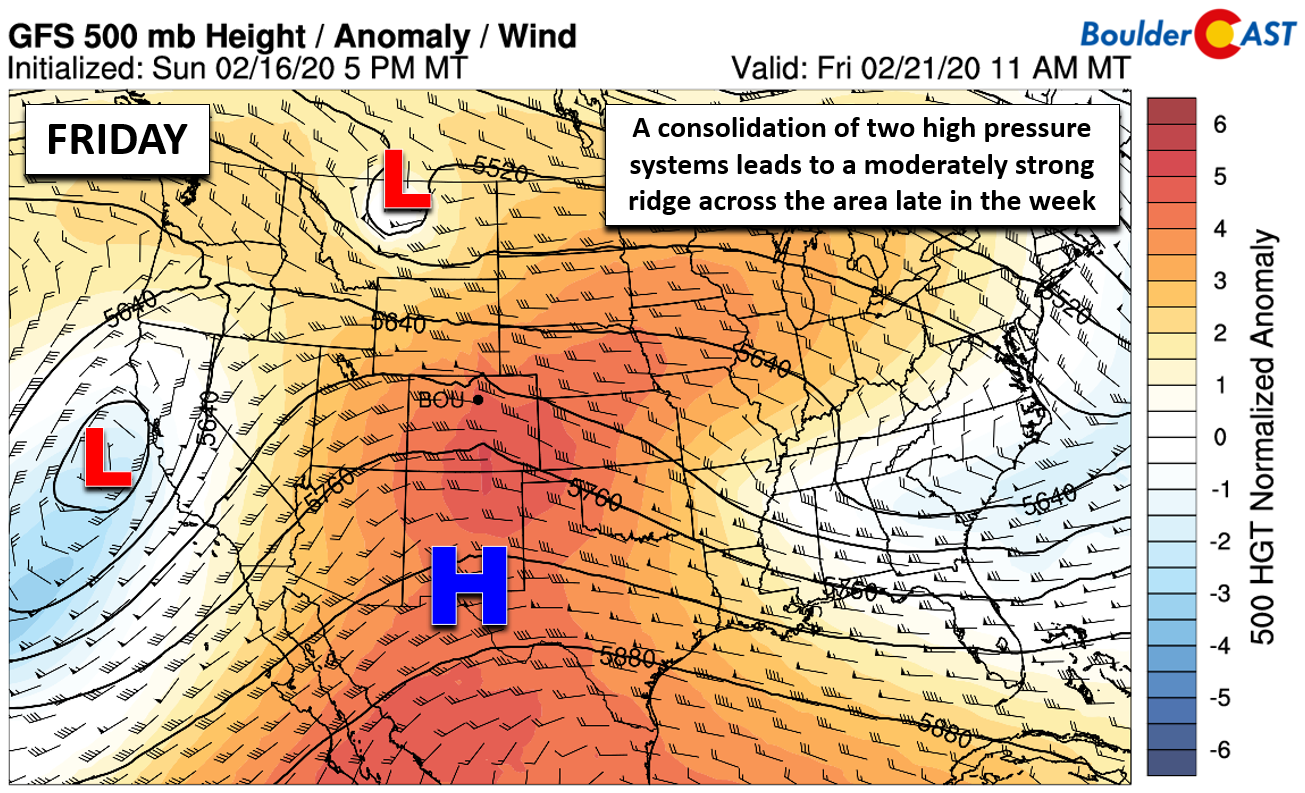
GFS 500 mb height anomaly forecast map for Friday. A potent ridge develops leading to much warmer temperatures and sunny skies.
Forecast Specifics:
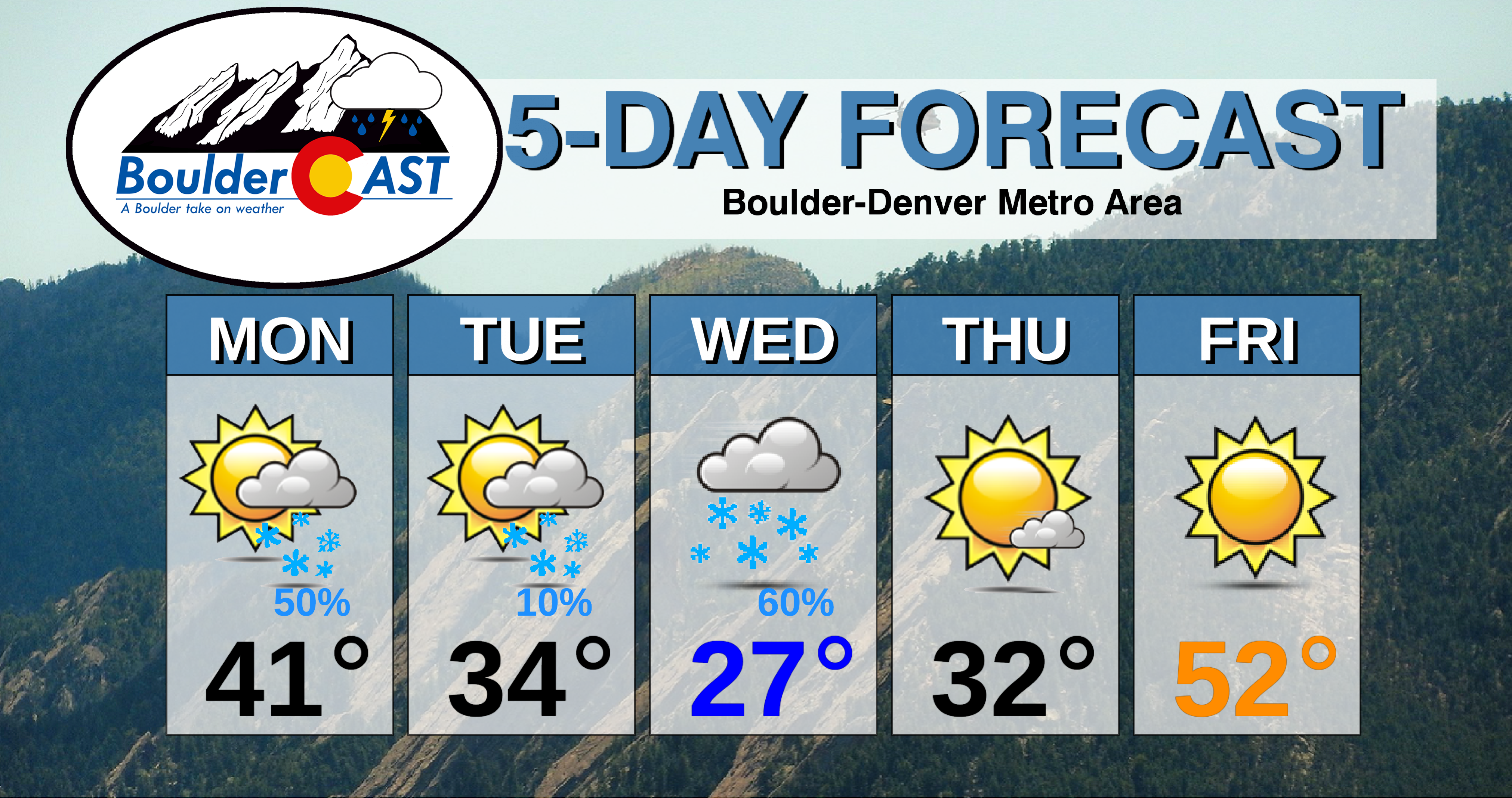
Monday: Partly cloudy skies through the day, with increasing clouds by evening with a chance of light snow across the Metro area from evening into the overnight hours. A dusting up to 2″ of accumulation is expected, highest south. Highs near 40 degrees on the Plains and in the upper 20’s in the Foothills.
Tuesday: A few linger morning snow showers, mainly south of Denver. Then partly sunny cold with highs in the middle 30’s for the Plains and middle 20’s in the Foothills. Flurries may redevelop across the area Tuesday evening with only a trace of snow expected.
Wednesday: Overcast and unseasonably cold. A good chance of snow develops from afternoon into the evening, possibly preceded by a short period of freezing drizzle. Highs in the 20’s across the Plains and Foothills.
Thursday: A few lingering low clouds in the morning, becoming mostly sunny. Highs in the low to middle 30’s on the Plains and low 20’s in the Foothills.
Friday: Sunny and much warmer. Highs return to the 50’s across the Plains and into the 40’s in the Foothills.
High Country: The best ski conditions will be on Monday with 6 to 14″ of fresh powder being reported from most ski resorts. Not bad considering this is a holiday! Light snow will be possible in the Mountains Monday morning, Monday night, and Wednesday evening. While northern Colorado got the brunt of the snow the last few days, the target will shift to southern Colorado through the week ahead. Check our PowderCAST page for always-updated weather forecasts for all of the Colorado ski resorts.
DISCLAIMER: This weekly outlook forecast is created Monday morning and covers the entire upcoming week. Accuracy will decrease as the week progresses as this post is NOT updated. To receive daily updated forecasts from our team, subscribe to BoulderCAST Premium.

.
Spread the word, share our forecast!


You must be logged in to post a comment.