Following a bitter cold and snowy January in the Front Range, the month of February so far has brought with it milder conditions. Last week we had our first 60-degree day in Boulder since just before Christmas, and even our first 70-degree day since late October. The warmer weather has been a welcomed reprieve, though it has rightfully confused some flowering plants across the area with early blooms. This warm weather was never going to last though — we’ve still got plenty of winter to go and this week will get us right back on-track with a two-part blast of Arctic air and snow headed for the Front Range. Read on for the latest details on the snowfall timing, amounts, and expected temperatures.
This week’s highlights include:
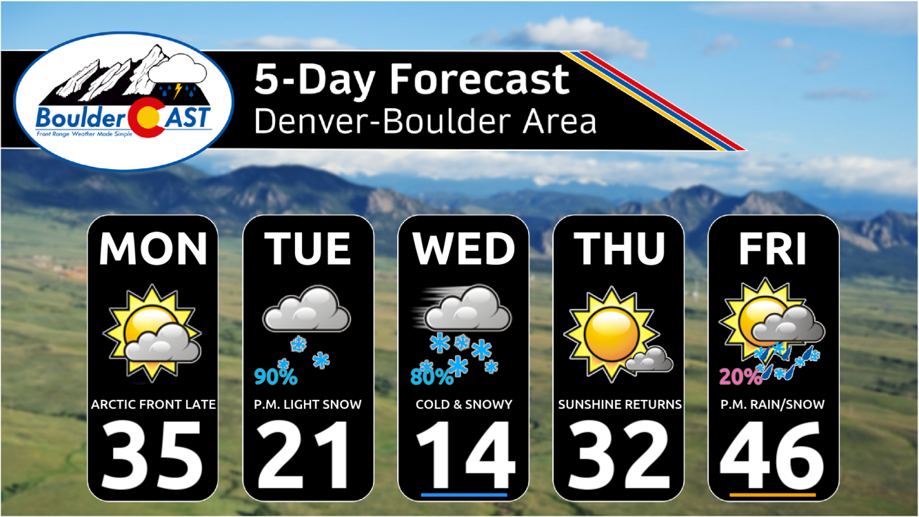
- Arctic Blast in Two Waves: Two blasts of Arctic air will drop across Colorado this week — the first late on Monday followed by a reinforcing shot late-day on Tuesday
- Very Light Snow Monday Night: Light snow possible Monday evening and night, with just a trace to 1″ of accumulation for most
- Several Inches of Snow Late Tuesday into Wednesday: A more substantial round of accumulating snow begins Tuesday afternoon and continues into Wednesday with 2-5″ in Denver, 3-8″ in Boulder and the Foothills.
- Arctic Air is Cold? Bitter cold air will accompany the snow with highs only around 20 on Tuesday and in the teens Wednesday, temperatures drop below zero Wednesday night
- Atmospheric River Brings Mountain Snow Late-Week: Another system will impact the state late in the week with heavy snow favored in some Mountain ranges, less certain what happens in the Boulder area but probably some light rain/snow
DISCLAIMER: This weekly outlook forecast is created Monday morning and covers the entire upcoming week. Accuracy will decrease as the week progresses as this post is NOT updated. To receive daily updated forecasts from our team, among many other perks, subscribe to BoulderCAST Premium.

Go Premium, get all the perks.
Daily Forecast Updates
Get our daily forecast discussion every morning delivered to your inbox.
All Our Model Data
Access to all our Colorado-centric high-resolution weather model graphics. Seriously — every one!
Ski & Hiking Forecasts
6-day forecasts for all the Colorado ski resorts, plus more than 120 hiking trails, including every 14er.
Smoke Forecasts
Wildfire smoke concentration predictions up to 72 hours into the future.
Exclusive Content
Weekend outlooks every Thursday, bonus storm updates, historical data and much more!
No Advertisements
Enjoy ad-free viewing on the entire site.
February has been warm so far, but this week won’t be
We’ve been following this shift back to much colder weather for many days now, alluding to this week’s surge of Arctic air about a week ago in our Premium discussions. While it initially looked like there would be quite a bit of snow associated with the cold air, the models have backed off somewhat on snow amounts this week for the area, favoring instead colder temperatures but less snow. However, we still have a prolonged period of intermittent light snow and very cold temperatures ahead this week as Arctic air oozes back southward engulfing our entire area in the days ahead.
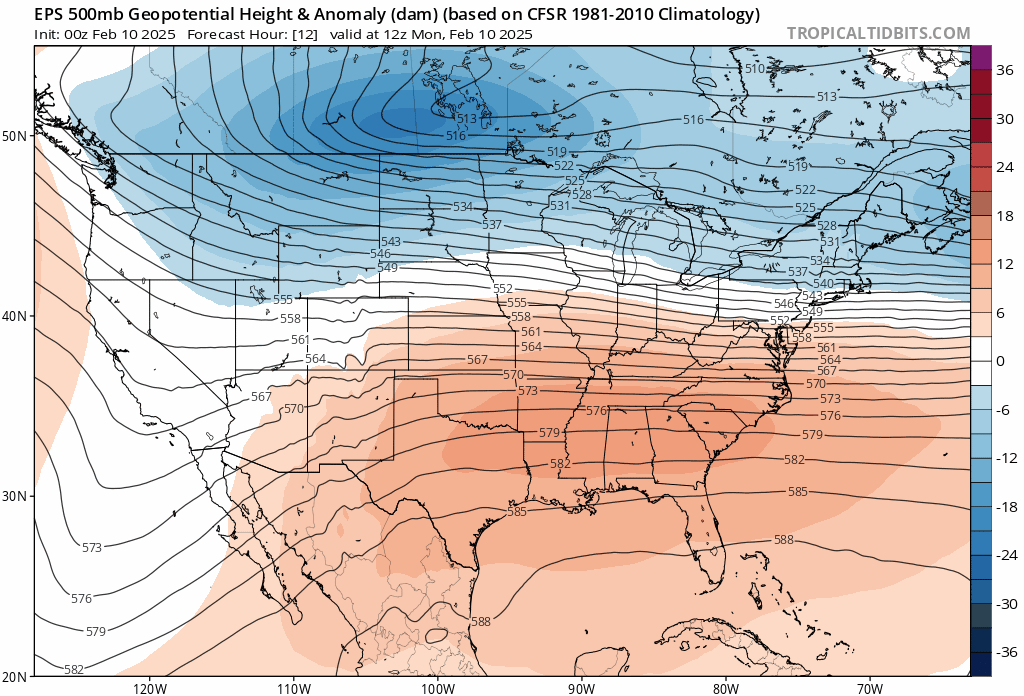
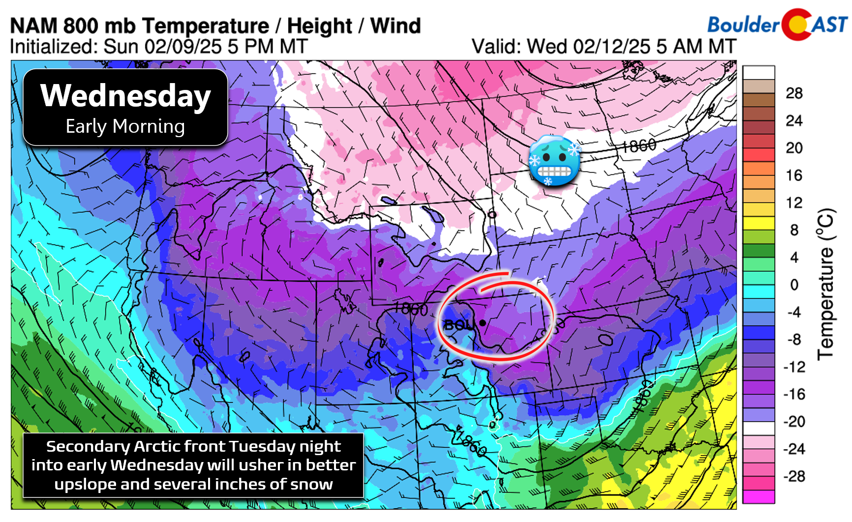
This week’s large-scale weather pattern will feature a cold trough digging into Colorado from western Canada late on Monday which will be accompanied by bitter cold air — not quite as cold as what we saw back in the middle of January, but still well below average for us. As shown in the European ensemble 500mb height anomaly forecast animation below, this trough will remain almost stationary over the state for a few days before exiting eastward by late-week. The upcoming weekend will see a secondary Pacific trough enter from the west, a moisture-rich atmospheric river that will bright heavy snow to the Mountains and a bit of unsettled weather to the Metro area as well.
First things first though, this week’s main trough will be accompanied by two surges of Arctic air originating from far northwestern Canada, the first Monday evening and a second Tuesday night. The secondary front is the colder/stronger of the two, as usual, with the cold airmass spreading across all of Colorado eventually by the middle of the week.
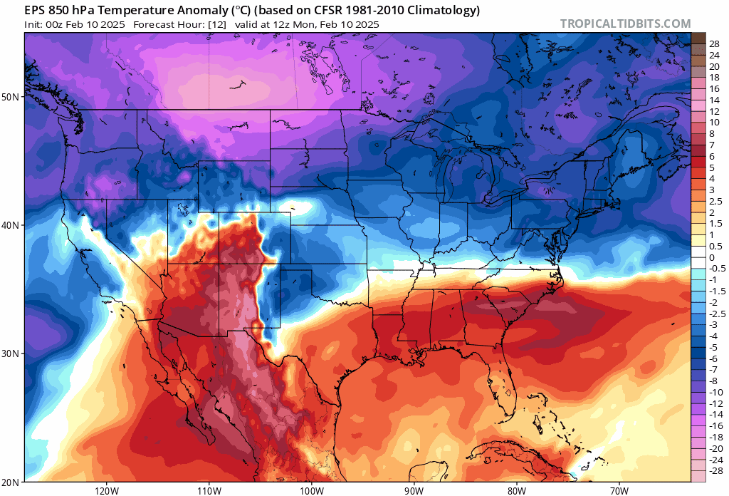
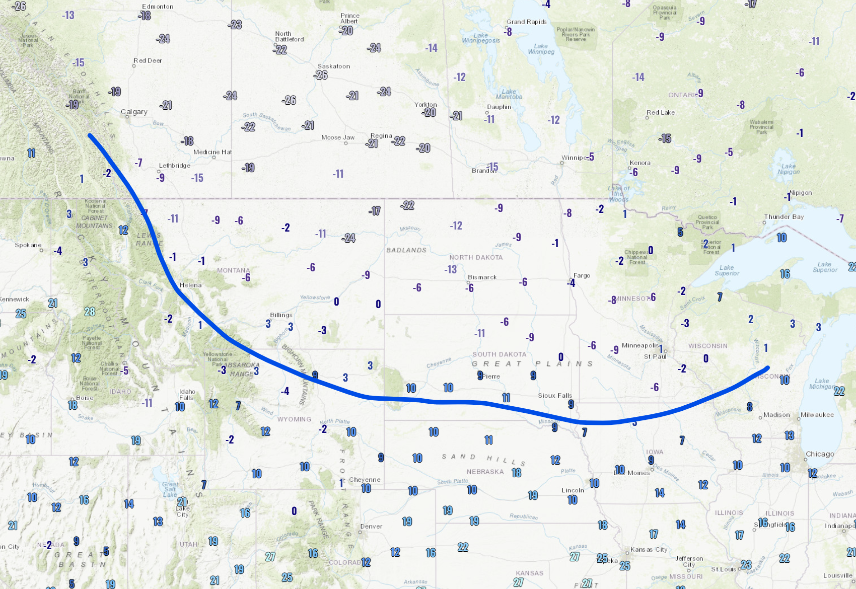
As of Monday morning, the initial Arctic cold front is situated about 300 miles north of Boulder, currently draped across Montana and far northern Wyoming. Temperatures are as cold as the negative 20s in southern Canada behind this front. Wind chills are as cold as -40°F!
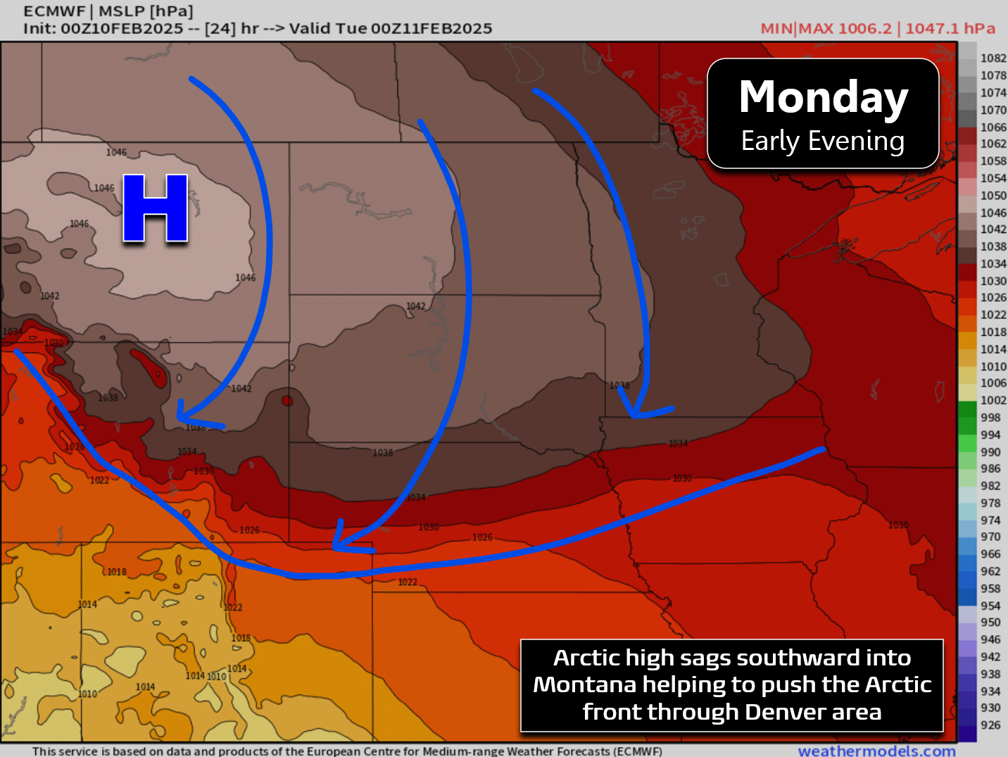
Zonal (westerly) flow across the Rockies will keep the front from moving too much early on Monday, but through the afternoon and evening it will accelerate southward across eastern Colorado, aided on the backside by a strong ~1050 millibar Arctic high pressure in eastern Montana. Our temperatures on Monday should push into the middle 30s before the front arrives during the afternoon hours.
Upslope flow will develop behind the front Monday evening and night, but with little moisture to work with and just weak synoptic forcings, this won’t amount to much actual snowfall across the Denver Metro area. Models have definitely backed off on snow amounts with this first front the last few days.
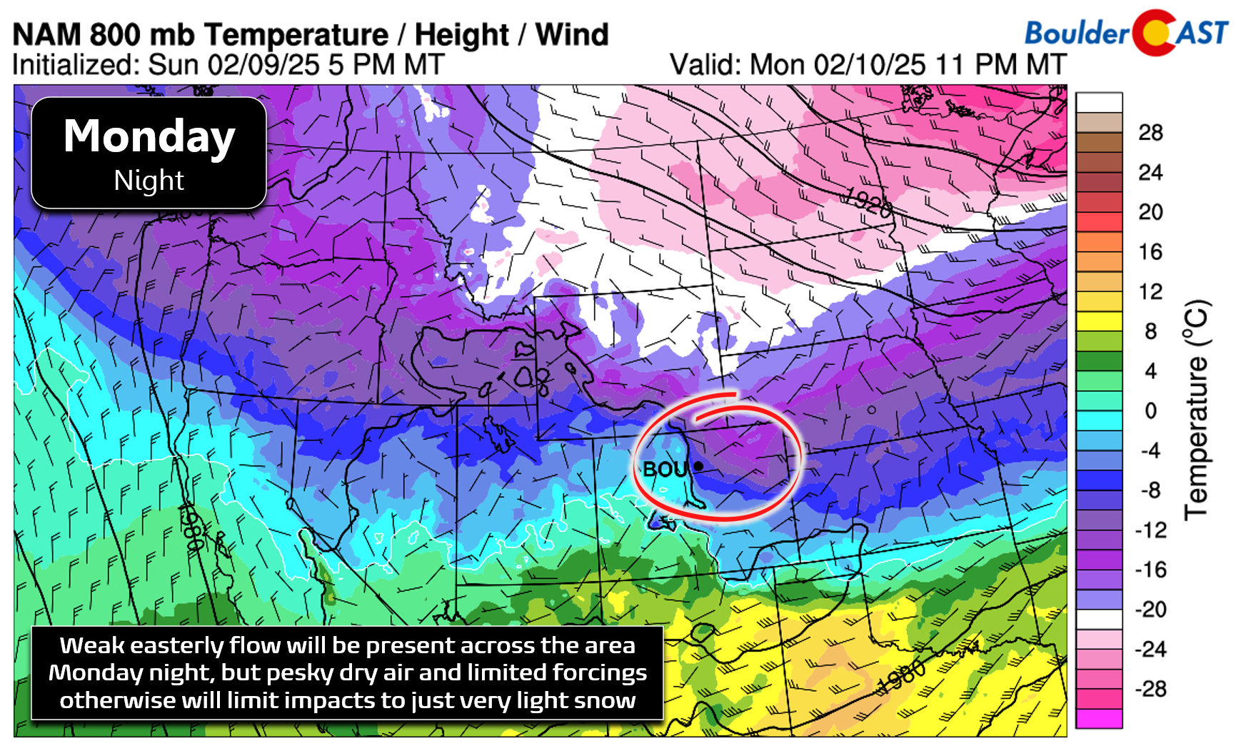
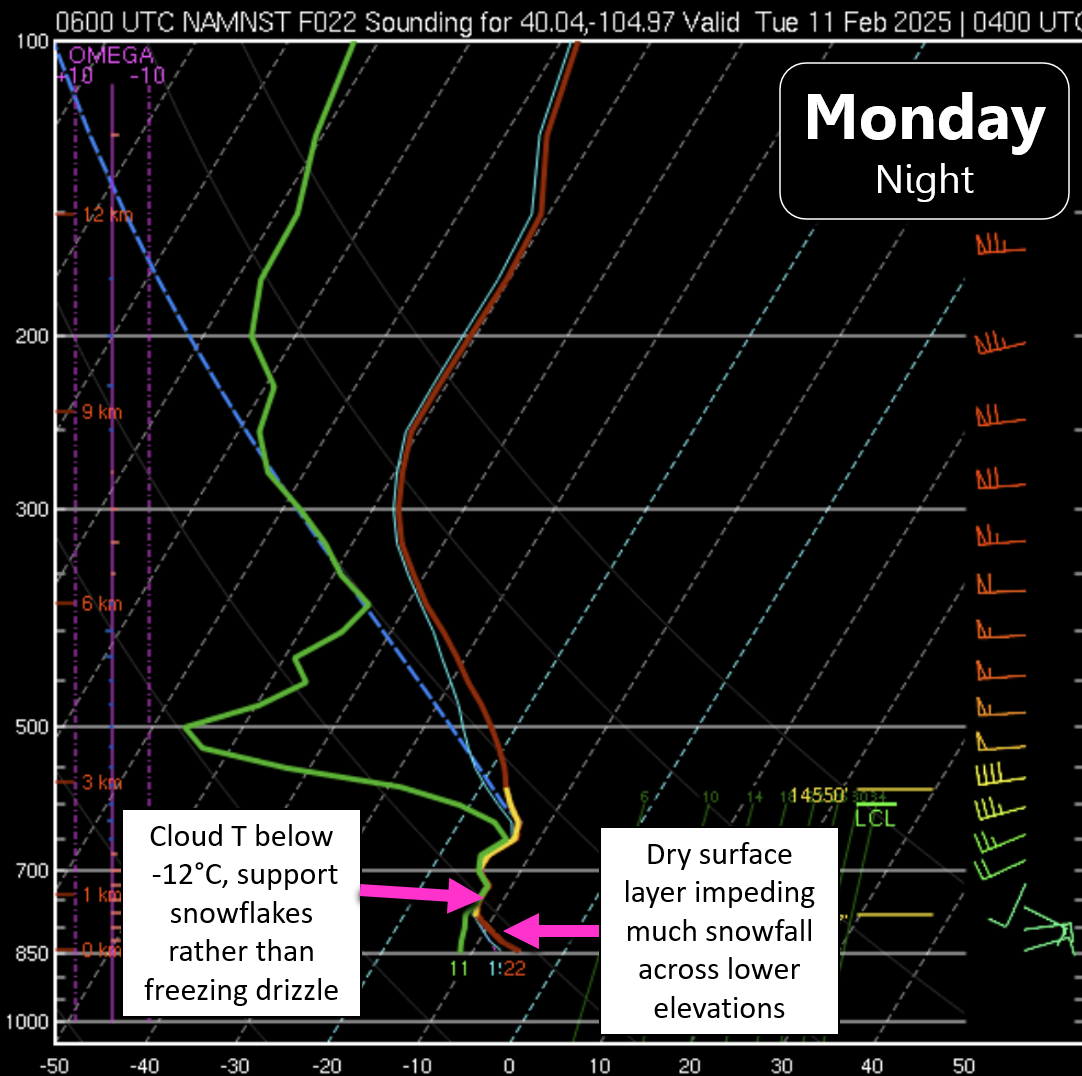
One of the main issues for the lower elevations will be a pesky layer of dry air near the surface. This dry layer will take most of the wind out of the sails of this first Arctic front, with minimal snowfall expected Monday night across the area. The good news is that cloud-top temperatures will be plenty cold enough for snow crystals to form Monday night, rather than freezing drizzle, which could occur under this setup had temperatures been a few degrees warmer.
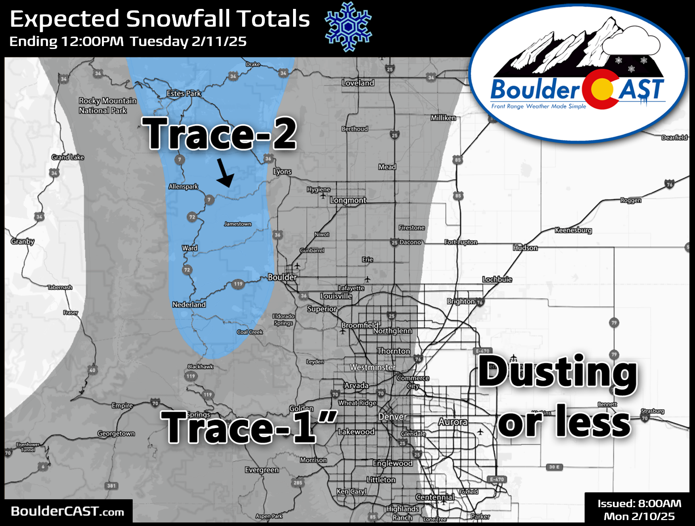
Nonetheless, the dry layer hugging the ground should slowly erode somewhat Monday night into Tuesday morning with a trace to 1″ of snowfall expected by sunrise Tuesday in most locations. Areas in and near the Foothills of Boulder and Larimer Counties can expect the most snow as they will be “above” the drier layer, with perhaps up to 2″ for areas above 7000 feet. Our snowfall forecast map for the first wave of Arctic air Monday evening through Tuesday morning is shown below. Temperatures will be falling into the teens Monday night, so even a small amount of fine-grain snowflakes may create slick travel early Tuesday on the roadways. However, it shouldn’t be all that bad.
High temperatures on Tuesday will be around 20° across the lower elevations, with mostly dry conditions expected through the morning and early afternoon. The secondary Arctic front will work in Tuesday afternoon accompanied by better synoptic forcing, stronger upslope, colder temperatures, a better injection of low-level moisture (goodbye low-level dry air!), and possibly some weak jet energy.
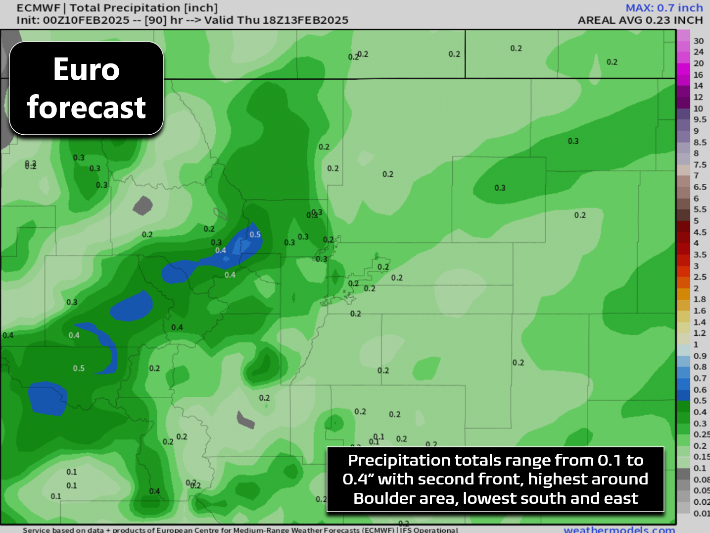
This favorable setup will stick around well into Wednesday, allowing for a prolonged period of light snowfall across the Front Range (12-18+ hours). All of these ingredients will spell out a better chance of snow region-wide Tuesday afternoon into Wednesday afternoon. Precipitation amounts will generally range from 0.1 to 0.4″ as shown in the Euro model forecast below — so not a huge storm for us, but with the bitter cold air entrenched, snow ratios will be up near 20:1 again, leading to decent fluffy snow accumulations across the entire area.
Our preliminary snowfall forecast map for the secondary snow event of the week Tuesday afternoon into Wednesday afternoon is shown below. The highest totals are expected on the Mountains and northern Foothills, including around Boulder.
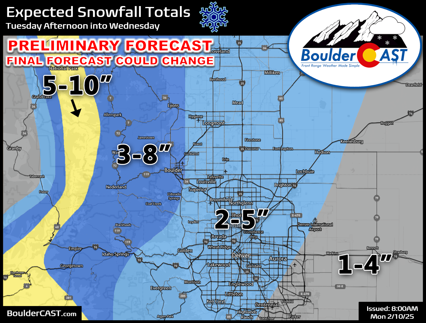
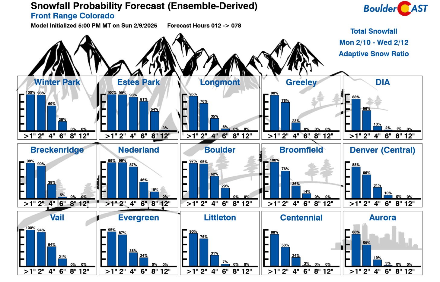
Our latest Snowfall Probability Charts fall right in-line with our forecast above — 1-5″ in Denver, 3-7″ in Boulder, and 4-8″ in the Foothills. We’re still fine-tuning the forecast for this snow event as there remains some model uncertainty in exactly how this event will unfold. The shallow upslope should at least allow for solid totals in the Foothills area, but away from the terrain we have some concerns. Stay tuned for updates on this one.
With light snow falling much of the day and clouds locked in, the colder push of Arctic air midweek will keep high temperatures only in the teens, perhaps even the lower teens for Wednesday. As skies clear out Wednesday night, below zero temperatures are anticipated for much of the area. Most likely readings will be in the negative single digits, with negative teens possible in the usual cold spots (Longmont, Erie, Greeley). On Thursday the Arctic airmass will start to loosen its grasp, aided by the arrival of shortwave ridging from the west. Though skies will be mostly sunny, we will struggle to get above freezing with the cold air stubborn to vacate and mix out.
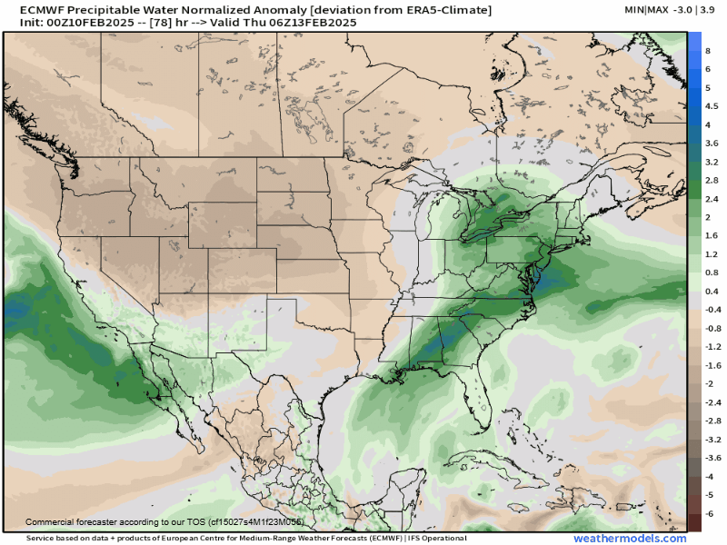
By Friday we should push back into the 40s as warmer southwest flow ensues ahead of the earlier mentioned Pacific trough. An atmospheric river will slam into southern California, with growing concern for flash flooding and mudslides in the recent Los Angeles County burn scars. This muted atmospheric river will reach Colorado on Friday with the central and southern Mountains favored to pick up significant orographic snow. There will be some type of cold front coming in east of the Mountains as well, with early indication that we could see late-day rain/snow showers here in Boulder and Denver as well. Accumulations Friday evening/night are possible for us, but should remain light. To be honest, we haven’t looked too closely at this late-week system yet as most attention remains on the Arctic Blast moving in Monday and lingering through Thursday morning.
We conclude with a high-level summary of this week’s weather:
- First Arctic front moves in Monday afternoon, with very light snow expected Monday night into early Tuesday (less than 1″ of accumulation)
- Cold on Tuesday only near 20 degrees for highs. Light, widespread snow develops during the afternoon and early evening from north to south. Snow continues through Wednesday morning if not afternoon. Total accumulation of 1-5″ in Denver, 3-8″ in Boulder and the Foothills. Snowfall amounts are still being fine-tuned.
- Wednesday will be bitter cold with highs in the low to middle teens. Wednesday night will be the coldest night with lows below zero everywhere.
- Thursday will be pleasantly sunny but cold — only around freezing for highs.
- Friday will see an atmospheric river slam into Colorado with heavy snow in some Mountain ranges. Less certain what happens in the Denver area, but expecting a late-day period of rain/snow changing to all snow Friday night. Minor accumulations possible.
Stay tuned for more and be sure to follow us on Twitter, Bluesky, Facebook, and Threads for impromptu weather updates in the coming days as this Arctic outbreak unfolds, or subscribe to get notified of our long-form updates here. We’ll be back Tuesday and Wednesday mornings with additional Premium Storm discussions diving deeper into the latest model data. Stay warm!
Forecast Specifics:
Monday: Partly cloudy skies and chilly. Highs reach the middle 30s by early afternoon, but fall thereafter as colder air arrives from the northeast. Very light snow will develop during the evening and overnight with up to 1″ of fine-grain accumulation possible by sunrise Tuesday.
Tuesday: Overcast and cold. There may be a few flurries around in the morning, but the day will be largely dry. The next front arrives in the afternoon with widespread light snow developing by early evening. Several inches of fluffy snow will fall Tuesday night into Wednesday. High only around 20 degrees on the Plains with teens in the Foothills.
Wednesday: Bitter cold with widespread light snowfall around in the morning, lingering into early afternoon in some areas. High temperatures only in the low to middle teens on the Plains with single digits in the Foothills. As skies clear Wednesday night, the entire area will drop below zero (0 to -15° Plains, -10 to -20° in the Foothills).
Thursday: After a frigid sunrise below zero, we’ll warm up nicely through the day towards the freezing mark under mostly sunny skies. Temperatures top out in the lower 30s on the Plains with lower 20s in the Foothills.
Friday: A mix of clouds and sun and warmer. A mix of rain/snow showers may develop in the late-day period, turning to all snow Friday evening. Accumulations are expected to be light but keep an eye out. Highs on Friday will be in the 40s to lower 50s on the Plains, with 30s in the Foothills.
Get BoulderCAST updates delivered to your inbox:
DISCLAIMER: This weekly outlook forecast is created Monday morning and covers the entire upcoming week. Accuracy will decrease as the week progresses as this post is NOT updated. To receive daily updated forecasts from our team, among many other perks, subscribe to BoulderCAST Premium.
Go Premium, get all the perks.
Daily Forecast Updates
Get our daily forecast discussion every morning delivered to your inbox.
All Our Model Data
Access to all our Colorado-centric high-resolution weather model graphics. Seriously — every one!
Ski & Hiking Forecasts
6-day forecasts for all the Colorado ski resorts, plus more than 120 hiking trails, including every 14er.
Smoke Forecasts
Wildfire smoke concentration predictions up to 72 hours into the future.
Exclusive Content
Weekend outlooks every Thursday, bonus storm updates, historical data and much more!
No Advertisements
Enjoy ad-free viewing on the entire site.
Enjoy our content? Give it a share!


You must be logged in to post a comment.