The week begins chilly after the dust storm-spawning cold front blew through on Sunday. Temperatures will be up and down through the week ahead, with several waves of Mountain snow expected. More notably, though, an interesting weather setup is developing late in the week that should bring a wave of light snow to the entire Denver Metro area.
This week’s highlights include:
- How about that dust storm which blew through on Sunday?
- Cooler to start the week with Mountain snow developing Monday evening
- Pleasant and warm on Wednesday as a short-lived ridge scoots through
- An interesting forecast is developing late in the week with a good chance of accumulating snow for everyone, heavy in the High Country

DISCLAIMER: This weekly outlook forecast is created Monday morning and covers the entire upcoming week. Accuracy will decrease as the week progresses as this post is NOT updated. To receive daily updated forecasts from our team, subscribe to BoulderCAST Premium.

A doozy of a cold front set the stage for a chilly Monday
The cold front this past Sunday came through the Denver area like a freight train. At BoulderCAST Station, temperatures dropped from the lower 60’s at 2:30PM on Sunday to below freezing by 4:00PM, then continued to fall slowly into the lower 20’s by midnight.
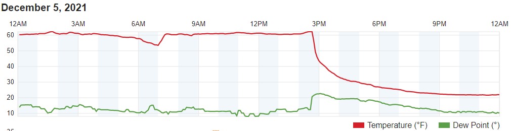
Temperature and dew point graph from BoulderCAST Station on Sunday. Look at that front!
In addition to the drastic drop in temperatures, the front was accompanied by gusty 40MPH winds from the northeast which picked up a plethora of dust from the drought-stricken plains of northeast Colorado (among other less-than-pleasant smells). The result was a brief but substantial dust storm which raced across the Denver area. Here’s a view of downtown as the dust rolled through.
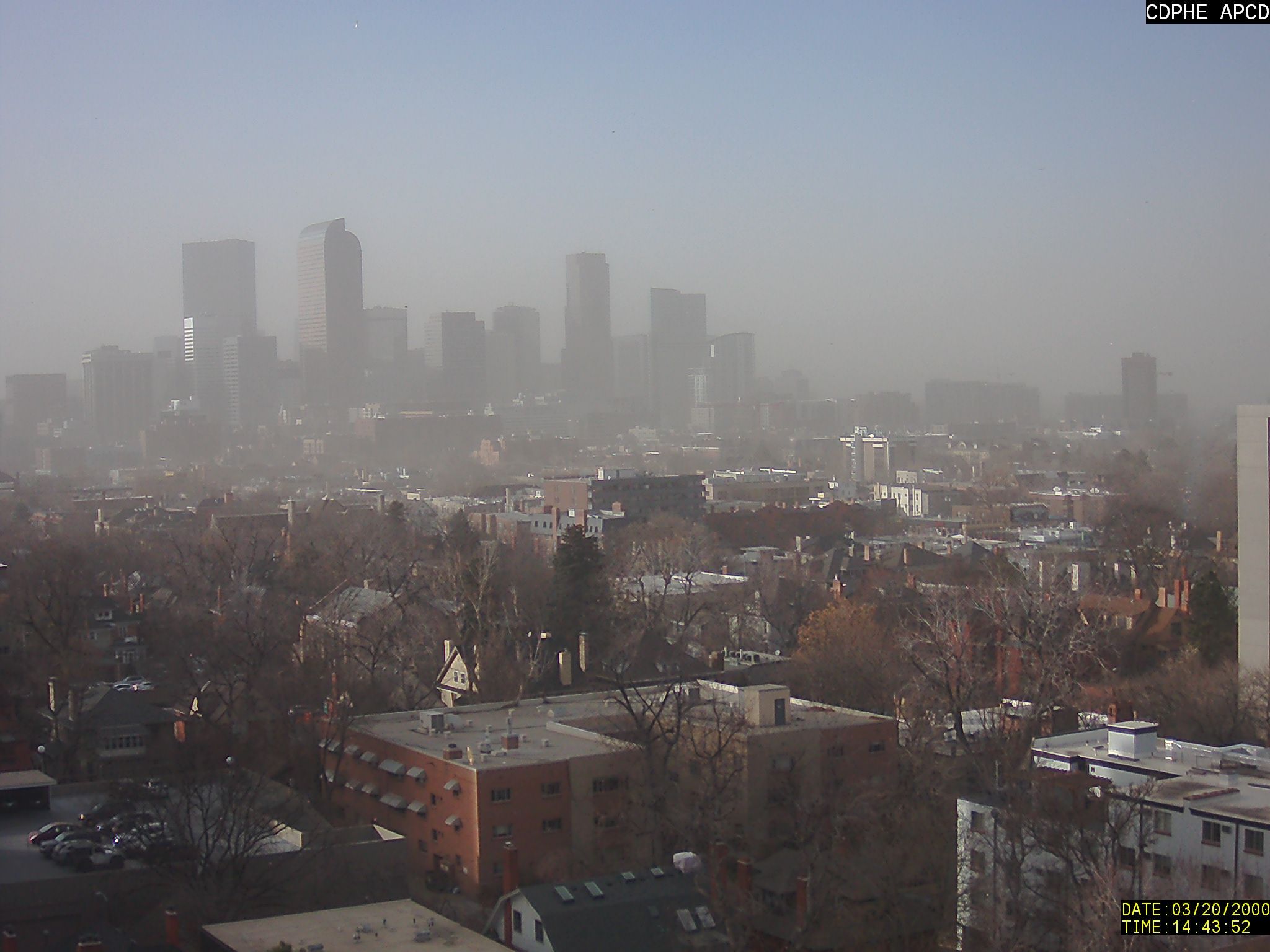
Dust blowing through downtown Denver at 2:45PM Sunday 12/5/21
This is the first true dust storm, also known as a haboob, which we can recall to hit Denver, though it was on the lower end of the scale compared to the larger ones which can occur in desert regions like southern Arizona. The video below of the dust cloud moving through is certainly surreal.
INCOMING!
A #haboob was spotted in #Denver today. Check out this incredible view from Centennial, CO. #COwx pic.twitter.com/GAQhQtv3Yh
— WeatherNation (@WeatherNation) December 5, 2021
Compared to yesterday, we’re some 40 degrees colder this morning across the Denver Metro area with temperatures in the teens and lower 20’s. Despite the shock factor, keep in mind that this is right around where we should be this time of year in early December for overnight lows! Remarkably, we’ve only been this cold a few times this season so far. The shallow cold airmass locked across the Plains has produced a few spotty flurries overnight but nothing in the way of accumulation. Denver still remains snowless this season.

Chilly temperatures early Monday morning across the Front Range
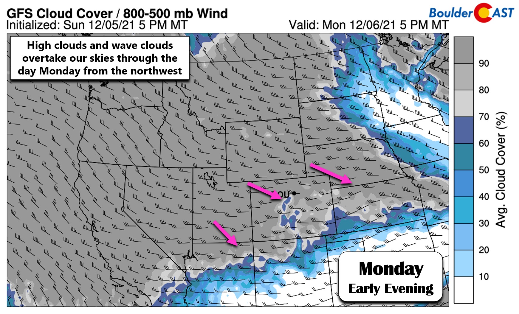
The colder, more seasonal airmass will stick around through the day Monday with temperatures reaching the upper 30’s to lower 40’s across the area. Confidence is low on the exact high temperature for Monday as warmer westerly flow will be attempting to erode the post-frontal cold airmass, though likely only partially succeeding. Furthermore, a weak system is coming ashore in the Pacific Northwest today with a substantial amount of high clouds, visible in the animation below as the green/red swath heading towards Colorado.
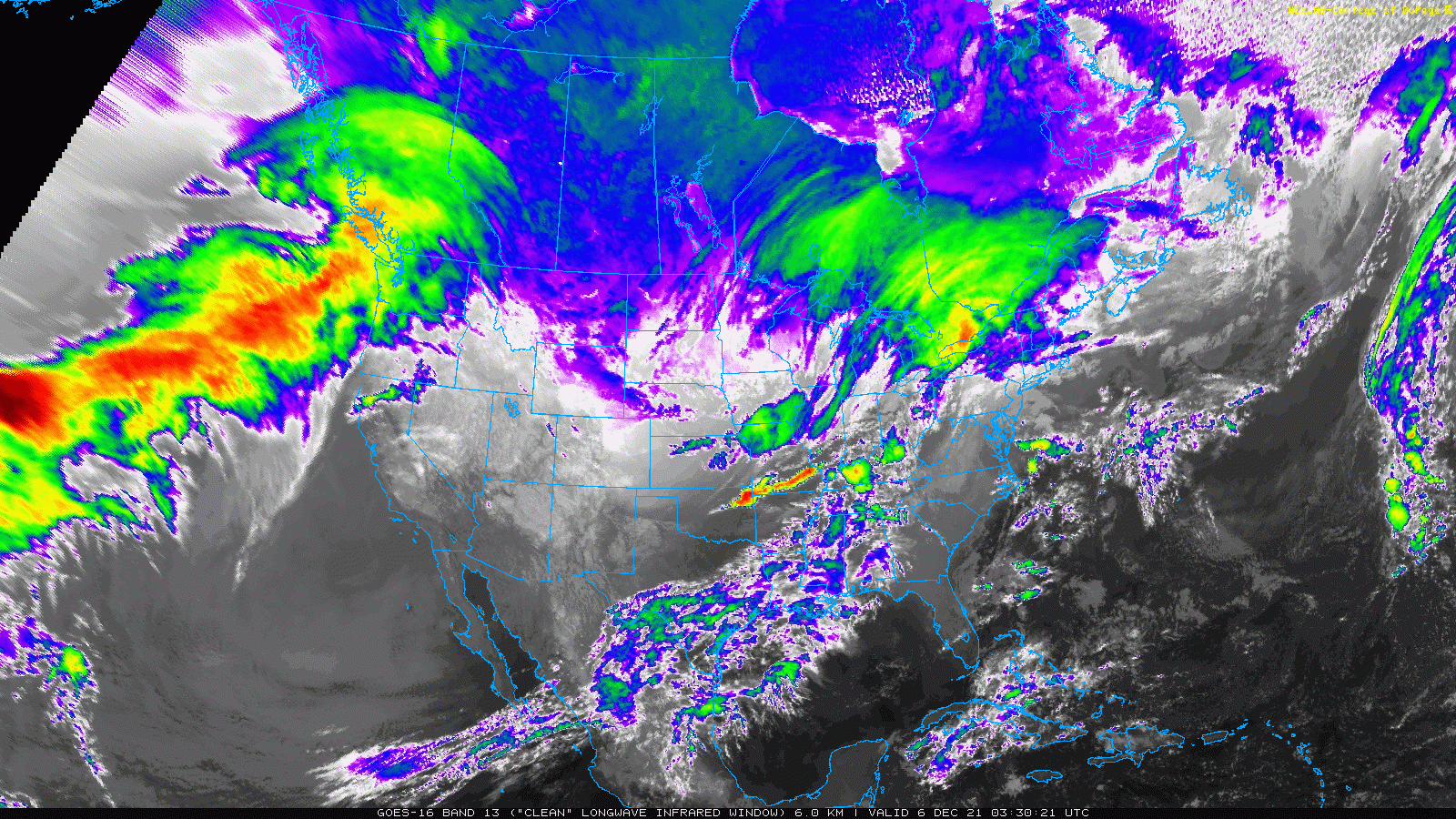
GOES-East infrared satellite animation from early Monday morning
We’ll start Monday with some sunshine but these clouds will be working in through the day helping to suppress the warmth from the already very low-angle December sun.
With that increasing moisture and westerly flow aloft, orographic snow will develop in the Mountains Monday evening and persist into early Tuesday. Under broad westerly flow (as opposed to northwesterly), most of the state’s ranges will see beneficial snow with a widespread 2 to 6″ expected statewide, with locally up to 8″.
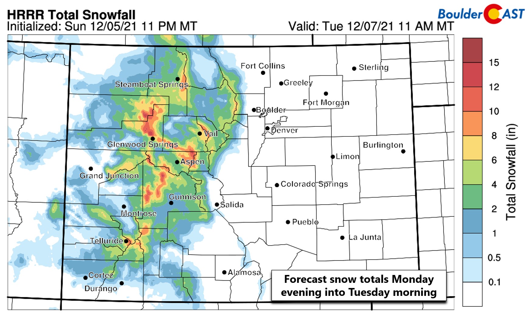
Last week we touched on the possibility that this system could bring some snow east of the Mountains as well, but that no longer appears to be the case as the system has weakened overall and evolved a little further west than models were indicating. There could be a few flurries generally east of the Denver area Monday evening, but nothing at all around Boulder. The timeline forecast below shows the potential for some sun early, but clouds will be ramping up by afternoon.

Moisture in the prevailing flow will be decreasing on Tuesday with snow showers dissipating in the Mountains through the morning hours. The one exception may be across southern Colorado which holds onto the moisture a little longer with snow persisting through the day. For the Boulder-Denver area, clouds will be decreasing with high temperatures warming back towards normal to around 50 degrees.
Wednesday: The nicest day of the week!
By all model accounts, Wednesday will be the most pleasant day of the week as a shortwave and short-lived ridge of high pressure pushes across Colorado. We’ll briefly get a nice southwesterly return flow and temperatures will get close to 60 degrees with a mix of clouds and sunshine. Make sure to enjoy the day as the weather will change abruptly later in the week…

Tracking a late-week storm for Denver’s first snow
Late in the week a Pacific storm system is forecast to come ashore and deepen as it approaches Colorado from the northwest. Most models currently show a rather potent trough pushing across the heart of the Rockies Thursday evening through early Saturday. While this is exciting, we should all keep our expectations in check for now since it is still about four days away. We’ve seen this signature in the models many times already this season, but it has yet to truly materialize for the Front Range with good-looking troughs eventually weakening or shifting northward before they arrive.

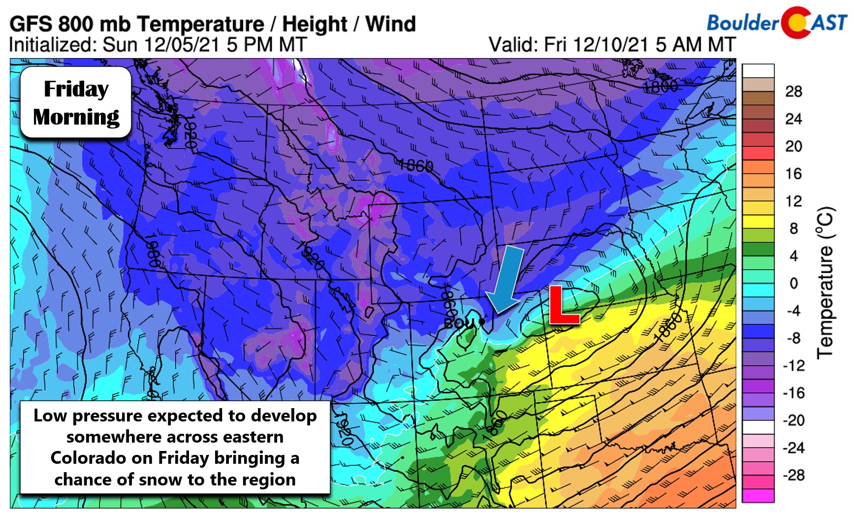
Nonetheless, we do anticipate big changes toward the tail-end of the work-week. The storm is currently slated to reach the Front Range Thursday night with upslope possibly producing a wave of snowfall east of the Mountains. We say possibly because the track is not certain right now, with both the GFS and European models indicating a northern track that would target primarily southeast Wyoming with the heaviest fetch of snowfall. Even with this track, however, a round of light accumulation is still possible if not likely for the Boulder and Denver area. The GFS low-level temperature and wind forecast below for Friday morning shows the colder air and upslope working into the Front Range.
The forecast animation below shows how the GFS model has been trending with each run over the last couple days as the low pressure develops on Friday. A low positioned in southeast Colorado would be ideal, but we’ve seen it come northward at times in various model runs.
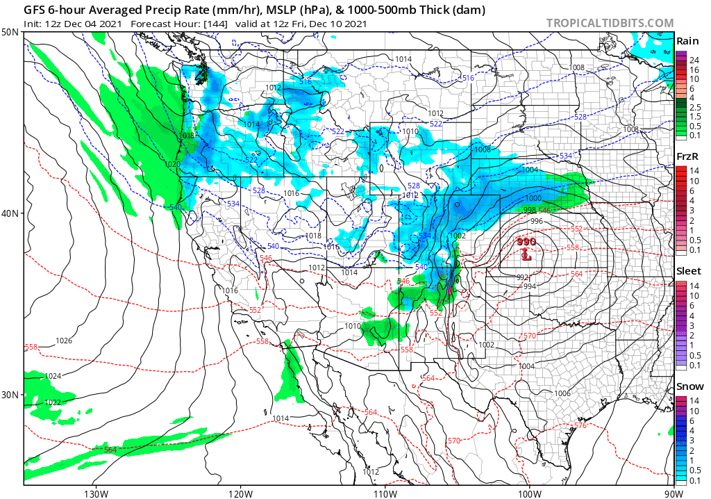
The latest runs of nearly every model indicate light snowfall accumulations with this system resulting from a period of steady upslope and shallow moisture across the Denver Metro area late Thursday night into Friday afternoon — so that’s good news at least. Denver may finally see its first accumulating snow of the season. Anywhere from a dusting to 4″ is on the table at the moment, but with many days to go before this one hits, things can certainly shift either direction.
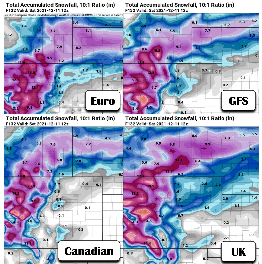
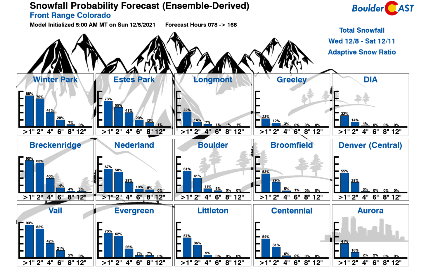
This far out, relying more heavily on the model ensembles is the best forecasting approach. Right now our latest snowfall probabilities don’t look too promising for this late-week storm, with a ~60% chance of seeing more than 1″ of snow in Boulder and Denver, and very low chances of seeing more than 4″ (<10%). Still, this will be an interesting forecast as the week progresses. We’ll continue to monitor the winter weather situation so do check back for updates in the coming days!
To close out the week, Thursday should still be somewhat mild ahead of the main cold front with temperatures topping out in the 50’s. After the front blows through, we may be lucky to reach the freezing mark on Friday with snow falling during at least part of the day. The trough should clear out for the weekend ahead with dry weather expected and moderating temperatures.
Stay up to date with Colorado weather and get notified of our latest forecasts and storm updates:
We respect your privacy. You can unsubscribe at any time.
Forecast Specifics:
Monday: A few morning clouds, then some brief sunshine before high clouds build in the rest of the day. Highs top out in the upper 30’s across the Plains and in the middle 30’s in the Foothills.
Tuesday: Overcast early, then some sunshine later in the day with seasonal temperatures. Highs around 50 degrees on the Plains with upper 30’s in the Foothills.
Wednesday: More sunshine and very mild with temperatures climbing to near 60 degrees on the Plains with middle 40’s in the Foothills. This shall be the nicest day of the week!
Thursday: Partly cloudy and cooler with our next storm approaching the area. Highs in the upper 40’s to middle 50’s on the Plains with upper 30’s in the Foothills.
Friday: Mostly cloudy with snow likely. Highs much colder in the lower to middle 30’s on the Plains with 20’s in the Foothills.
Mountains: Orographic snow will increase across the Mountains Monday after sunset with light snow lingering into Tuesday morning. 2-6″ is possible with locally up to 8″ from this first system. Things will mostly dry out Tuesday afternoon through Wednesday (but we can’t fully rule out spotty snow showers) before the next stronger storm arrives Thursday into Saturday. The Mountains will likely see a round of heavier snow from this late-week trough with temperatures remaining near to below normal.
Help support our team of Front Range weather bloggers by joining BoulderCAST Premium. We talk Boulder and Denver weather every single day. Sign up now to get access to our daily forecast discussions each morning, complete six-day skiing and hiking forecasts powered by machine learning, first-class access to all our Colorado-centric high-resolution weather graphics, bonus storm updates and much more! Or not, we just appreciate your readership!
Spread the word, share the BoulderCAST forecast!


You must be logged in to post a comment.