A doozy of a forecast will unfold this week as extremely cold Arctic air overtakes the Front Range late on Wednesday accompanied by a quick shot of fluffy snowfall. However, the main story will be the bitter cold with wind chills dropping to dangerous levels for an extended period. This may be the coldest air to reach our area in decades. We discuss the timing of the powerful front, just how cold it will get and give our early thoughts on potential snowfall accumulations.
This week’s highlights include:
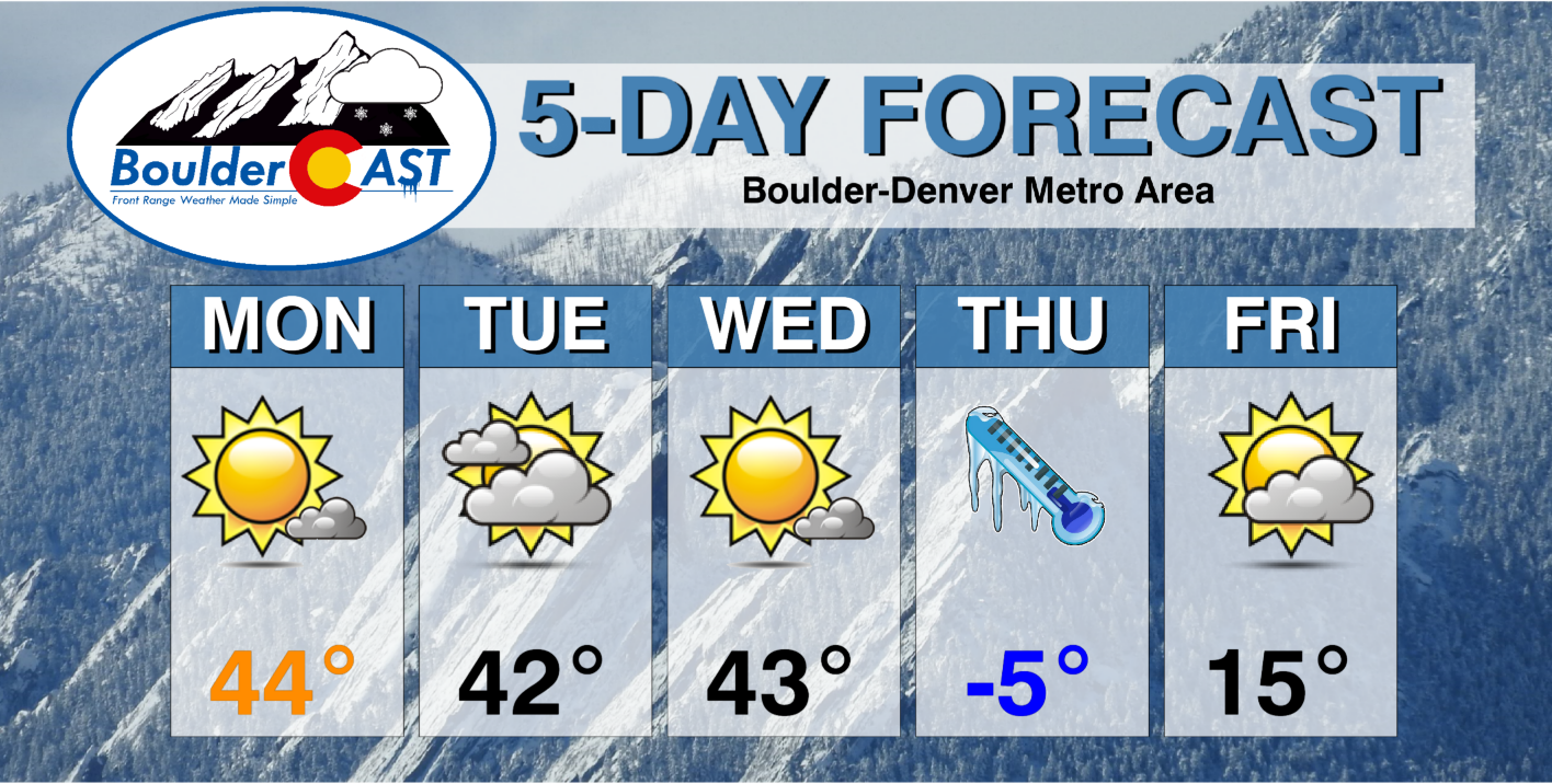
- Monday and Tuesday will be “business as usual” with highs in the low to middle 40s and quiet weather
- Wednesday will be somewhat mild ahead of the Arctic front, but things go south very quickly late in the day
- Temperatures plummet well below zero rapidly with a quick shot of moderate to heavy snow Wednesday evening/night
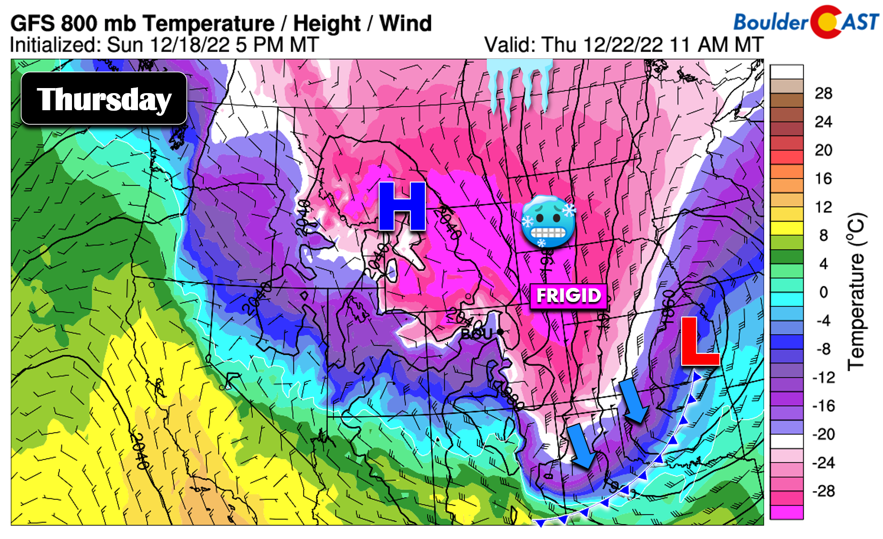
- Thursday’s high temperatures will be below zero, perhaps well below zero, for the entire area
- Coldest temperatures will be Thursday morning and Friday morning in the range of -15 to -25°F
- Friday will be warmer and tranquil but only in the teens
DISCLAIMER: This weekly outlook forecast is created Monday morning and covers the entire upcoming week. Accuracy will decrease as the week progresses as this post is NOT updated. To receive daily updated forecasts from our team, among many other perks, subscribe to BoulderCAST Premium.
A pair of pleasant days to begin the week
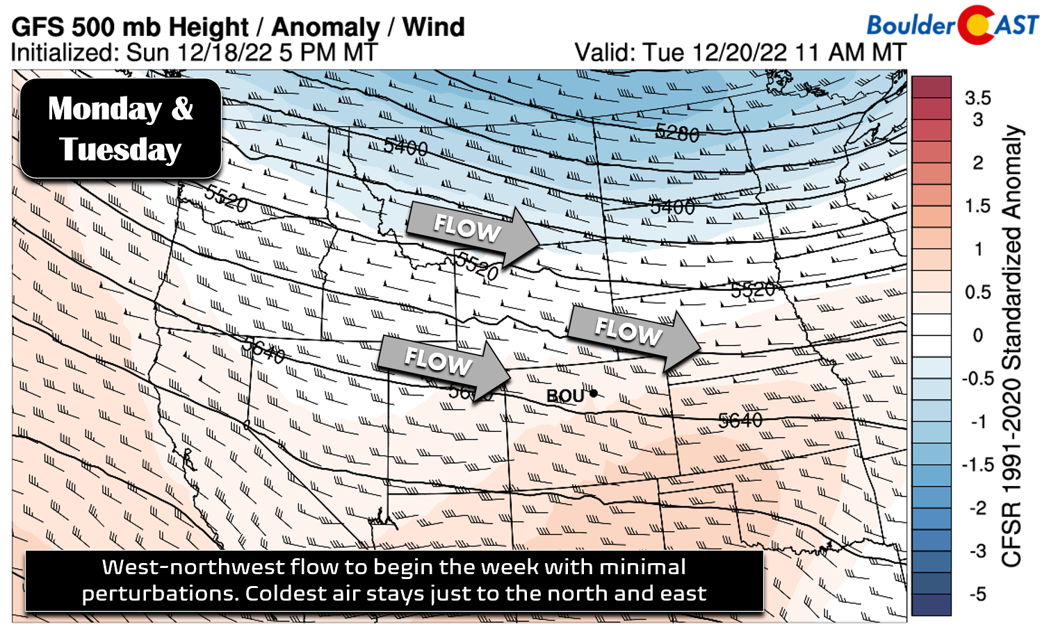
Undoubtedly you’ve heard the murmurs of an extreme and dangerous cold snap headed towards our area later this week. While absolutely true and a major concern in the mid-term forecast, we unfortunately must begin the discussion with the rather mundane “business as usual” weather setup for the first couple of days this week in Colorado. Moderate west-northwest flow will be over the central Rockies Monday and Tuesday leading to quiet conditions for the Front Range, albeit with some gustiness in the Mountains at times. Across the lower elevations, weak downslope and a mix of wave clouds and sun will prevail.
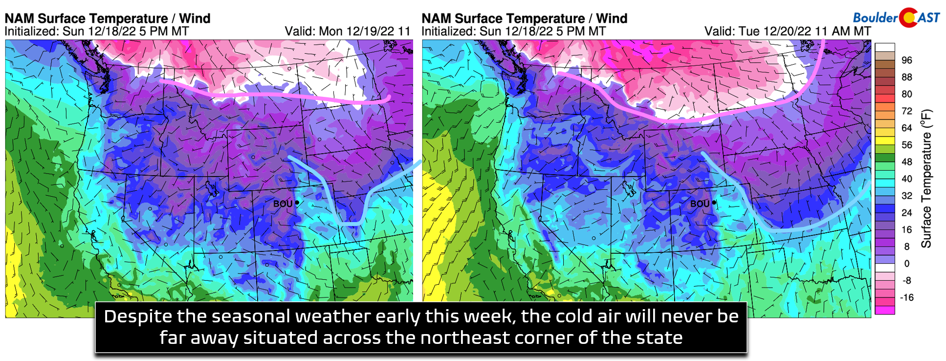
The 500mb map above is somewhat misleading, though. Despite some weak ridging noted aloft over the area, shallow Arctic air lurks beneath this setup, though this colder air will remain out across the northeast corner of Colorado through Tuesday while the Denver Metro area will be milder under downslope. In the surface temperature forecast graphic below, note the position of the lingering cold air both Monday (left) and Tuesday (right) out along the Nebraska and Kansas borders. Also note the position of the secondary, extremely cold airmass which will be steadily marching southward out of central Canada into Montana and the Dakotas. That will come our way as well in due time…
Look for highs in the low to middle 40s both Monday and Tuesday across our area with light winds and partly sunny skies.
The polar plunge begins on Wednesday!
There is always some uncertainty with Arctic outbreaks across our area due to the protection the nearby Mountains sometimes offer by sheltering the Front Range from direct hits. Most global weather models have been advertising this week’s impressive cold blast for the last week or more, but these types of outbreaks are often not well-forecasted that far in advance. Arctic air is extremely dense and has a lot of inertia. Once you get it moving in a certain direction, it tends to keep moving that way, but that initial nudge can be hard to initiate which causes the models to struggle in the extended. It’s a lot easier to get cold air into the northeast corner of Colorado than it is into the Front Range — getting that westward push our way is often a sizable hurdle. Nonetheless, models have stuck to their very cold guns this week and the polar plunge that develops on Wednesday and lasts through Friday is all but confirmed at this point. It’s just a matter of pinning down the details on exactly how cold it will get and how much snow may accompany this weather system which is packing that bitter cold and thus extremely dry Arctic air…
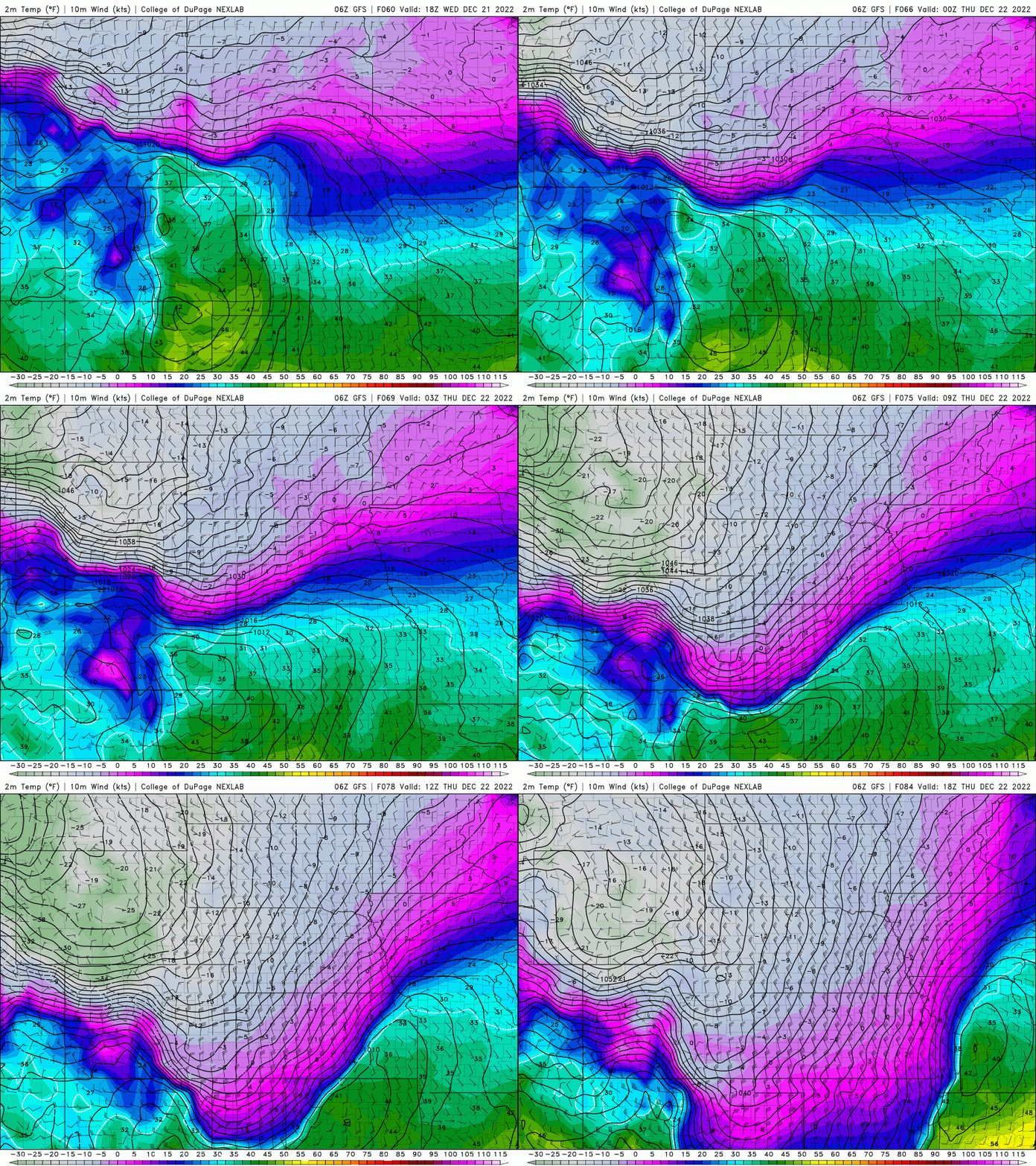
Wednesday will be a day to remember! Most models indicate that the Front Range will be able to dodge the cold air for one more afternoon at least with temperatures climbing into the 40s again before the intense Arctic front arrives in the evening. That seems like the most probable scenario in our opinion, though there are a few models which bring a chilly pre-frontal airmass in beforehand (the one the has been lurking in Nebraska all week), perhaps during the late morning or afternoon. Thus, know that there is some uncertainty with regards to the timing of things and just how warm Wednesday will be. For now though, we’ll expect highs to reach the 40s by afternoon time on Wednesday. Please don’t get lulled to sleep by the rather normal-feeling Wednesday afternoon. The cold front will blast through during the evening hours setting the stage for one of the sharpest drops in temperature we can recall for our area. We’ll literally plummet from 40°F around 3PM down as low as -10°F by midnight. The temperature drop accompanying this front could be some 40°F in one hour or less. Below is a look at the sharp surface front surging through in the latest GFS model run. Look at those temperatures on the backside — those are indeed Fahrenheit, folks!
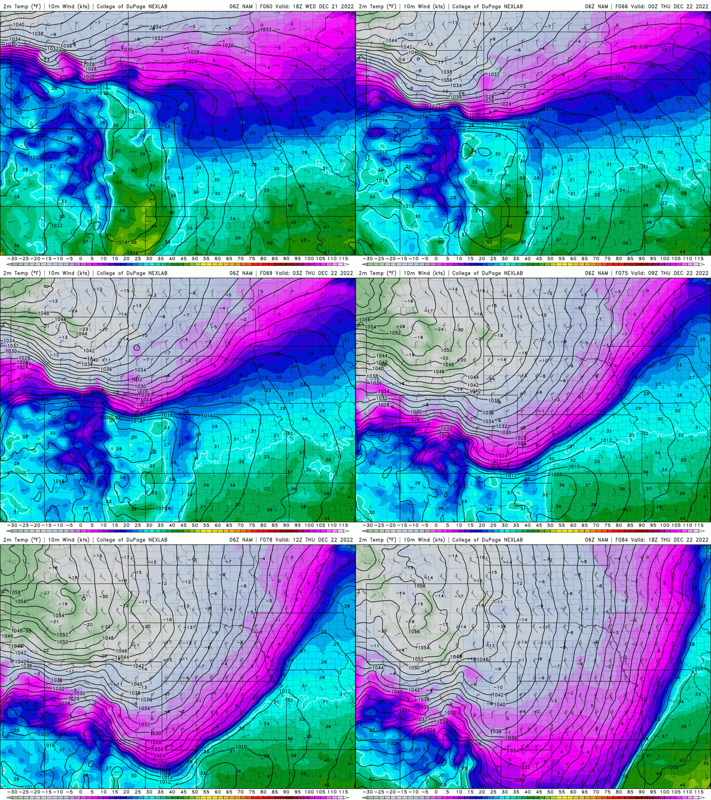
The NAM model is a few hours slower with the front, but the ultimate outcome is the same — dangerous cold taking over Wednesday night!
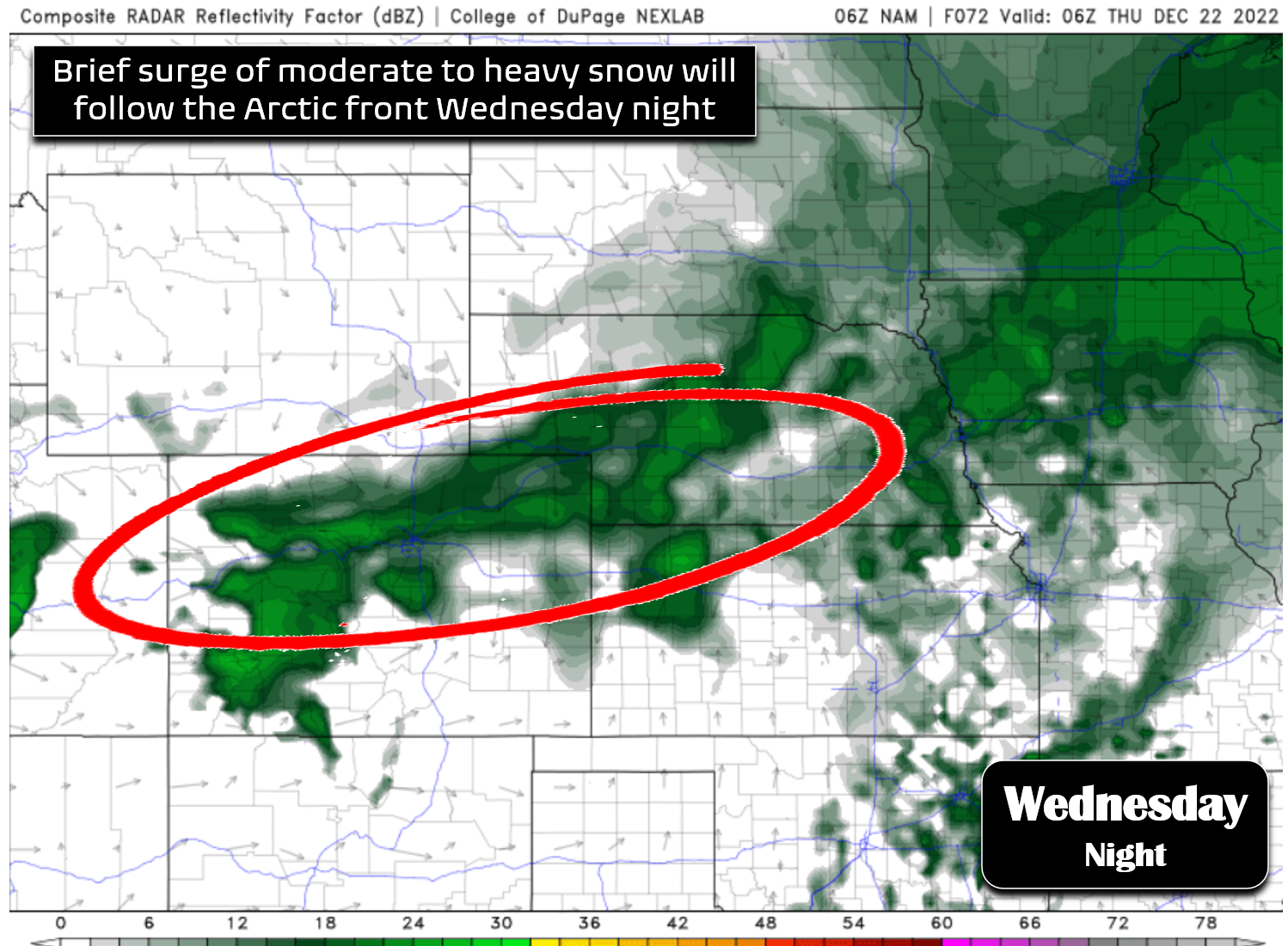
As the cold air surges in across eastern Colorado, there will be a brief window for snowfall to occur, mainly spawned by the powerful front itself but also the overhead jet stream which will put our area somewhat in the favorable left-exit region. We’re fairly confident that there will be a short period of moderate to potentially heavy snowfall just on the backside of the front Wednesday evening/night — that is very common for these Arctic outbreaks. A simulated radar forecast from the NAM model at 11PM Wednesday night is shown below — the narrow band of heavy snow parallel to the front is easy to spot.
This type of setup will not produce a ton of snow in the Boulder-Denver area. There’s only about a 6-hour window for snowfall as the front moves through before the extremely cold, moisture-starved air will filter in and shut things down rapidly. Basically we’re looking at an intense snow band that broad-brushes the area with 2-4″ of fluff Wednesday evening/night, followed by a few hours of lighter upslope snow in the western suburbs which would wrap-up before sunrise on Thursday. The GFS and NAM (shown below), as well as the Euro model, are all predicting less than 0.25″ of moisture across the Metro area with the front. That doesn’t seem like much, but the cold air will promote rather high snow ratios leading to a nice blanket of snow for the area!
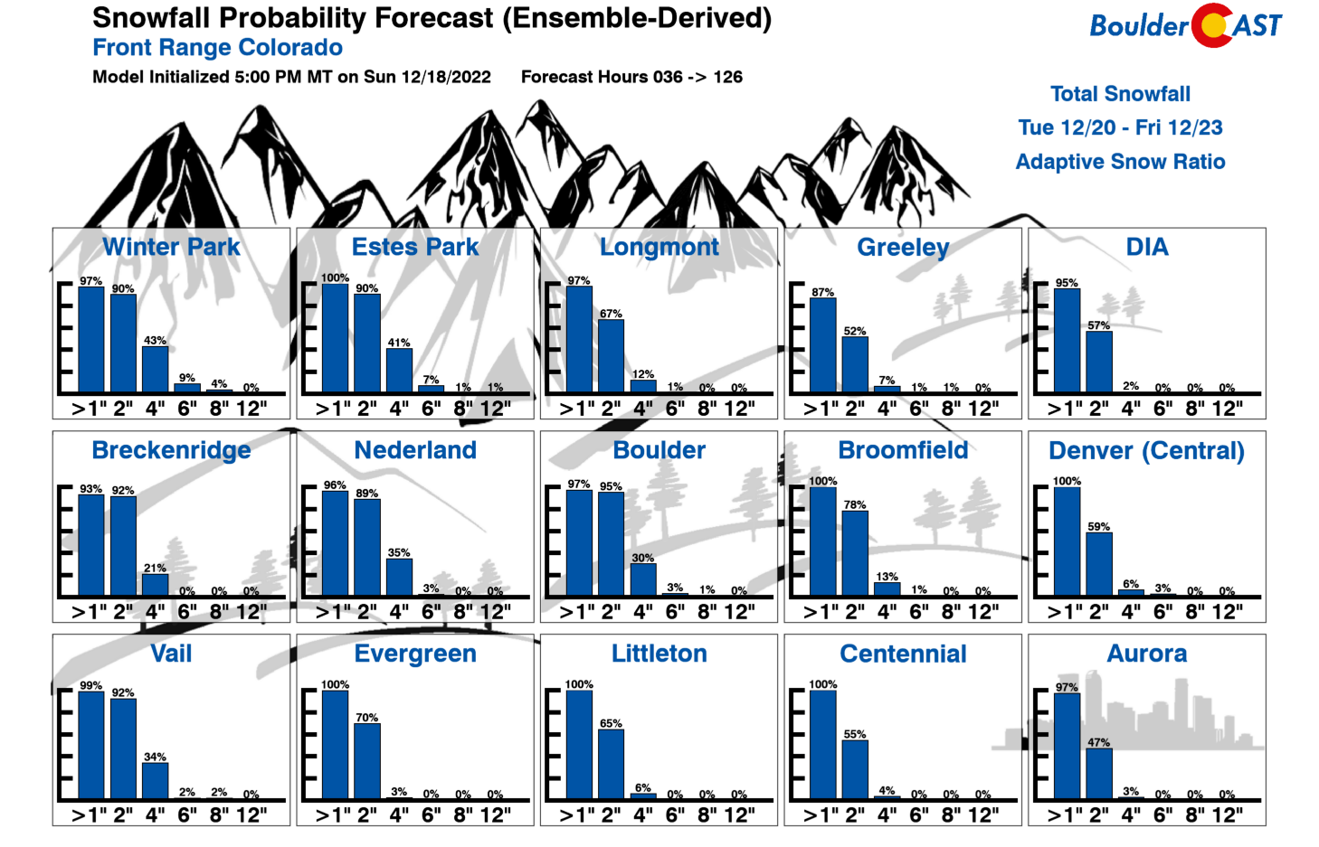
Most of us will pick up a quick 1 to 4″ from this event, but usually snowy spots such as Boulder could see slightly more. Our latest Snowfall Probabilities are in-line with our early expectations for the mid-week snow. Keep in mind that any snow that falls will stick around for several days making for slick travel. Most of the handy chemicals used to lower the melting point of snow on roads/sidewalks won’t function when temperatures are well below zero!
After we bottom out in the negative teens Wednesday night, we are unlikely to warm back above ZERO on Thursday with the coldest core of the polar airmass entrenched over eastern Colorado. Our current forecast calls for a high of -5°F on Thursday in Boulder. That may actually be optimistic as models have been trending colder overall of late…
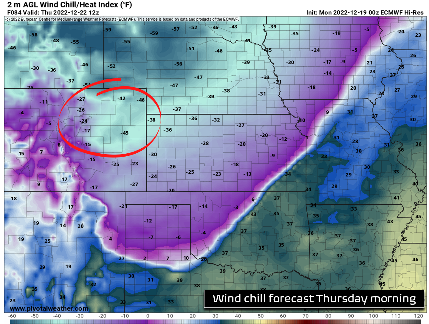
Wind chills will hold at dangerous levels Wednesday night all the way into Friday morning at least. The worst of the winds will reside east of Interstate 25 across the Plains with gusts of 15-30+ MPH Wednesday night into Thursday. Denver and Boulder will be more sheltered from the north-northwest winds by the terrain so it won’t be as dangerous here. Winds chills will bottom out between -20 and -30°F near Boulder but go as low as -50°F in the northeast corner of the state. Definitely take the necessary precautions to protect yourself, family, pets and livestock. Frostbite can occur rapidly in these conditions — trust me, I know all to well from my experience having endured wind chills below -100°F in the recent past.
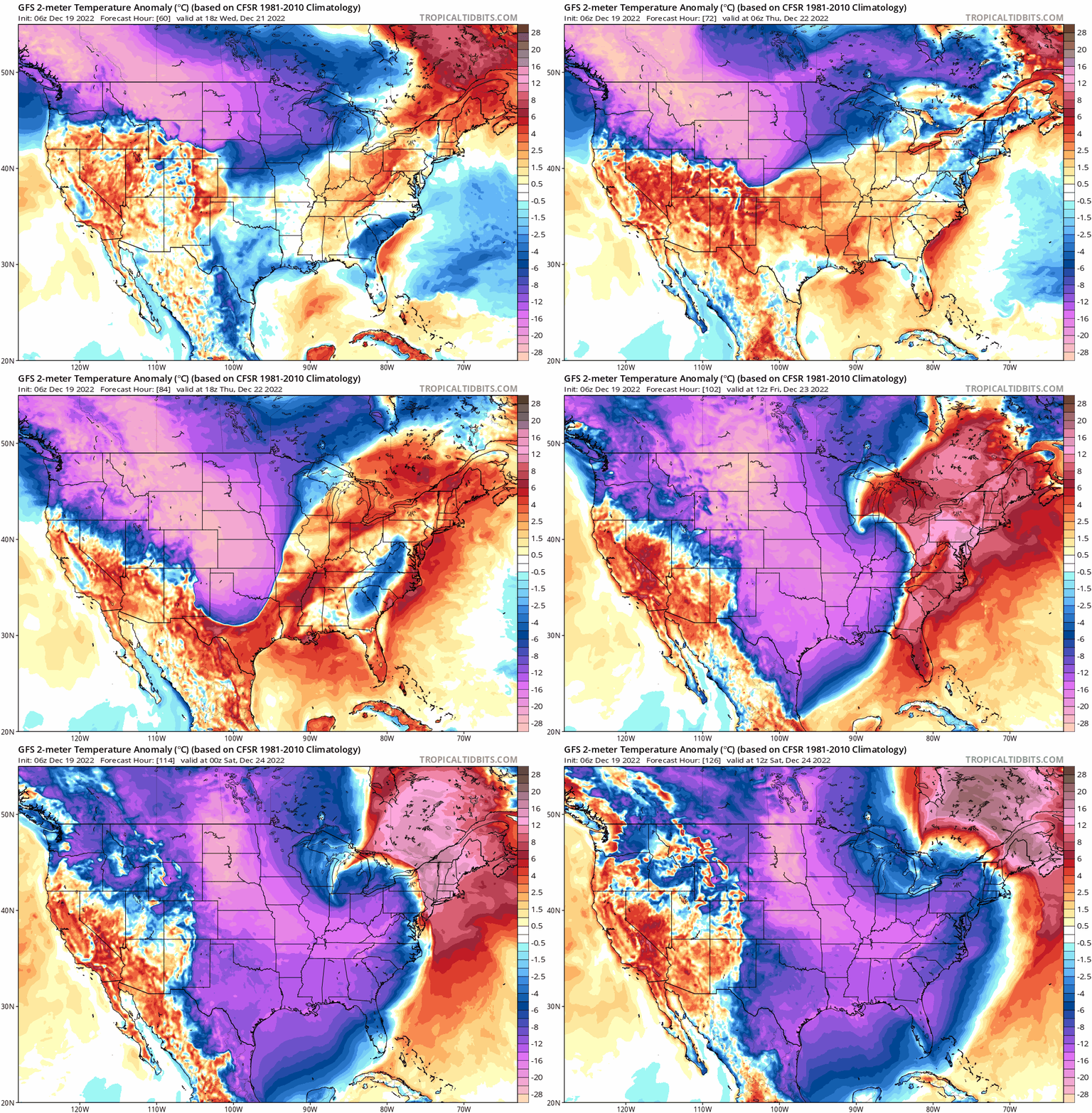
This cold air outbreak ultimately could be one for the record books across much of the nation with Arctic air flooding southward and pushing out the Deep South, the Gulf of Mexico and even Florida. We could very well be looking at another energy crisis in Texas this week.
Thursday night we drop back into the negative teens and 20s again. With some breaks in the cloud cover around, we may even see some areas get colder, perhaps nearing -30°F in the low-lying South Platte River Valley from Greeley to Sterling.
By Friday, the Arctic air starts to moderate a tad with highs expected to get back somewhere into the teens. That’s a long way out in the forecast — so this could change a bit. While still unseasonably cold, Friday will certainly be more manageable and typical for our area in late-December.
The holiday weekend ahead looks mostly quiet across the area, though there could be some light snow in the Mountains Friday night into Saturday. Downslope flow will (hopefully) quickly scour away the Arctic airmass with temperatures warming up nicely for the weekend into the 40s and perhaps even the 50s by Christmas Day! Hooray!
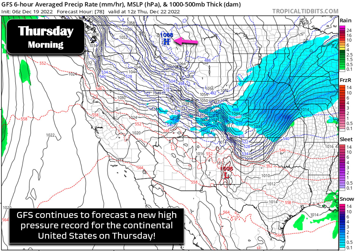
Another less discussed facet this week is the potentially record-breaking Arctic high pressure that is propping up this very cold airmass. The GFS model has consistently been predicting a sea-level pressure over 1060 millibars in Montana. The latest run, shown below, produces an off-the-charts 1068 millibar high. If that verifies, this would shatter the long-standing high pressure record for the continental United States, one which was set at 1064 millibars back in 1983 in Miles City, Montana. It’s important to note that other models are coming in lower right now with this high (Euro 1059mb, Canadian 1059mb), but still this should raise some flags about just how extreme this week will be. Ensembles and climatology suggest this type of cold air outbreak only recurs roughly every 15 to 30 years on average!
Be sure to check back as we’ll post additional forecast updates this week discussing the looming record cold and quick brush of snow.
Forecast Specifics:
Monday: Partly to mostly sunny with highs in the middle 40s on the Plains with lower 30s in the Foothills.
Tuesday: More cloud cover, but still seasonal with highs in the low to middle 40s on the Plains and in the lower 30s in the Foothills.
Wednesday: Partly cloudy and mild by early afternoon reaching the lower to middle 40s again. An intense Arctic front blasts through in the evening bringing a brief wave of snow which could be heavy at times. 2-4″ of accumulation is expected in the evening and overnight. Temperatures plummet well below zero by midnight with wind chills dropping to dangerous levels (-20 to -40°F).
Thursday: Possibly a few lingering light snowflakes in and near the Foothills/Palmer Divide in the early morning. Otherwise, partly to mostly cloudy and extremely cold with highs in the negative single digits on the Plains and in the negative teens in the Foothills. Wind chills will be dangerous throughout the day.
Friday: After another bitter cold morning way below zero, temperatures moderate through the day with highs likely in the teens on the Plains and just above zero in the Foothills.
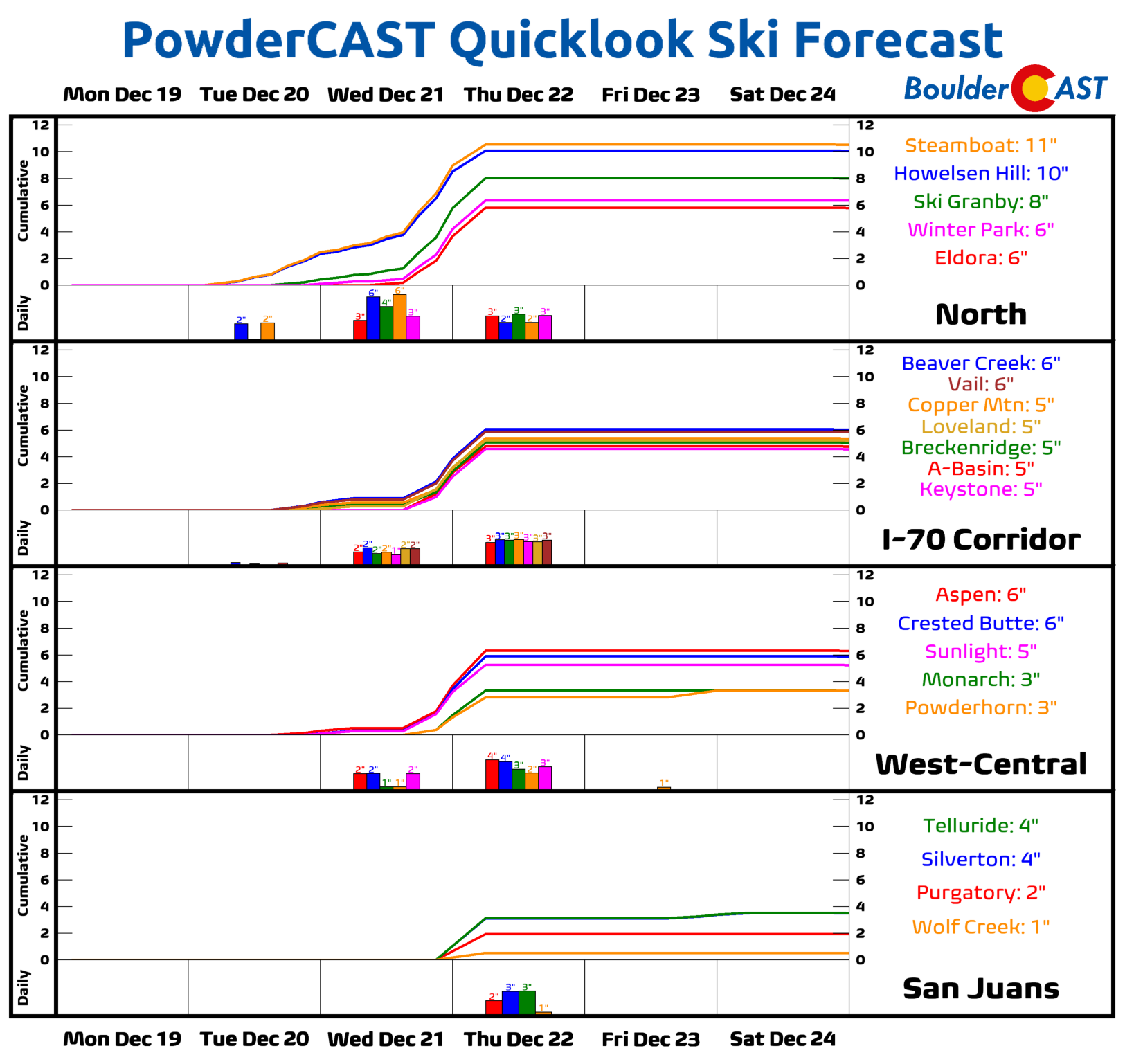
High Country: The northern Mountains will see a shot of snow with the main storm system Tuesday into Thursday along with plummeting temperatures. Places like Steamboat may see a foot of snow. The dangerous cold and wind chills will limit the potential for skiing though. Use extreme caution if heading up the Mountains this week. Otherwise, things quiet down late week with just a slight chance of light Mountain snow Friday night into Saturday as temperatures begin their climb back up towards normal for the holidays.
Help support our team of Front Range weather forecasters by joining BoulderCAST Premium. We talk Boulder and Denver weather every single day. Sign up now to get access to our daily forecast discussion email each morning, complete six-day skiing and hiking forecasts powered by machine learning, first-class access to all our Colorado-centric high-resolution weather graphics, bonus storm updates and much more! Or not, we just appreciate your readership!
Spread the word, share the BoulderCAST forecast!






You must be logged in to post a comment.