The week ahead will remain somewhat cooler and drier than normal as a weak trough stays entrenched and monsoon moisture continues to be difficult to come by. However, a favorable setup for severe thunderstorms will exist across northeast Colorado early in the week with hail the main risk. Overall temperatures will stay mostly below normal in the days ahead but they will trend back towards 90 degrees by week’s end.
This week’s highlights include:
- Converging jet streams over Colorado on Monday will fuel another round of severe thunderstorms, the greatest risk being east of Interstate 25
- Storm chances lingers on Tuesday but storm coverage and intensity is expected to decline — more severe but this time well east of Denver
- Wednesday is the only 100% dry day of the week as shortwave ridging passes through leading to abundant sunshine
- The late week period will see temperatures climb back near 90 degrees with isolated storms returning
- The monsoon has been on a hiatus lately, but that changes for the upcoming weekend
DISCLAIMER: This weekly outlook forecast is created Monday morning and covers the entire upcoming week. Accuracy will decrease as the week progresses as this post is NOT updated. To receive daily updated forecasts from our team, among many other perks, subscribe to BoulderCAST Premium.

Go Premium, get all the perks.
Daily Forecast Updates
Get our daily forecast discussion every morning delivered to your inbox.
All Our Model Data
Access to all our Colorado-centric high-resolution weather model graphics. Seriously — every one!
Ski & Hiking Forecasts
6-day forecasts for all the Colorado ski resorts, plus more than 120 hiking trails, including every 14er.
Smoke Forecasts
Wildfire smoke concentration predictions up to 72 hours into the future.
Exclusive Content
Weekend outlooks every Thursday, bonus storm updates, historical data and much more!
No Advertisements
Enjoy ad-free viewing on the entire site.
Severe threat remains early in the week
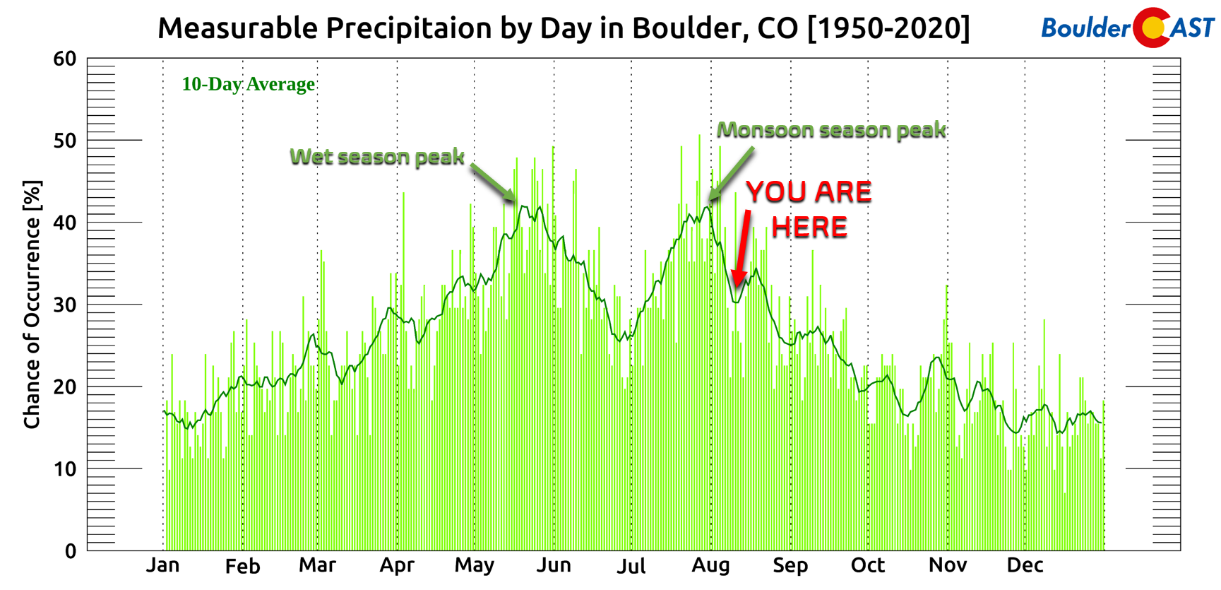
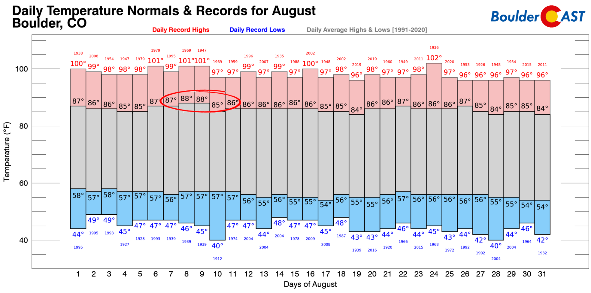
Climatologically speaking, August is a month where both temperatures and precipitation chances decline across the Front Range as we move further away from the apex of summer heat in July and monsoon season slowly winds down. The annual peak in monsoon activity is still discernible in Boulder’s precipitation chance climatology through the end of the August.
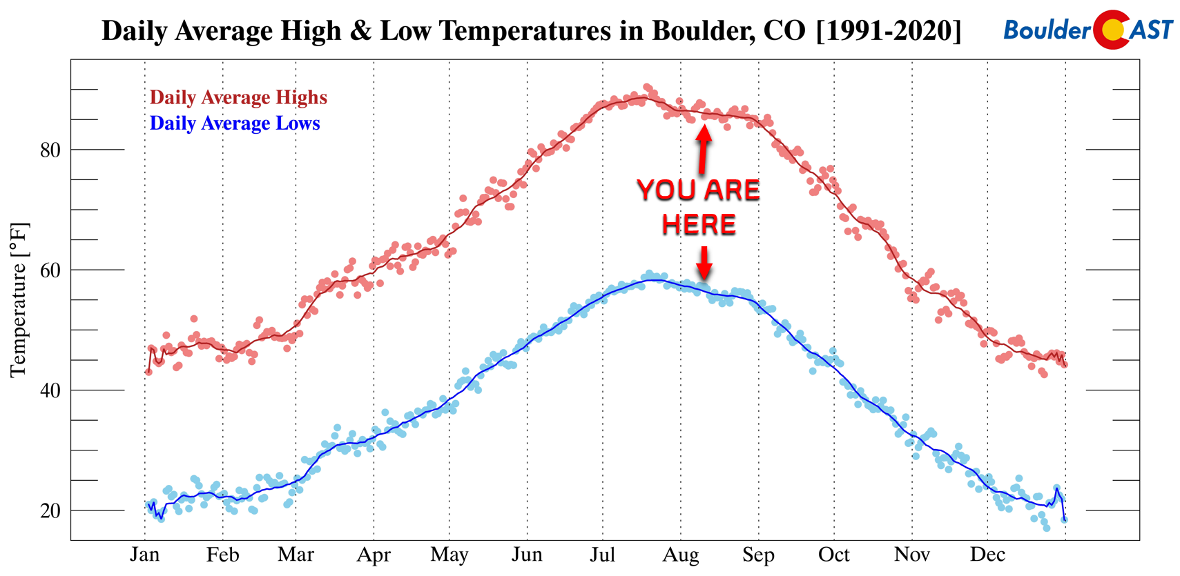
Temperatures typically top out in the mid to upper 80s this time of year, with overnight lows in the upper 50s. Keep this “normal” August weather in mind as we discuss the weather for the week ahead…
While temperatures will indeed be somewhat cooler this week, precipitation chances will linger a bit, including the threat of severe storms on Monday and Tuesday. The setup again is spurred on by anomalously strong jet draped across the central Rockies with generally swift west-northwest flow present over our area. In fact, there are two jets — both the subtropical jet and mid-latitude jets are coming together right over Colorado on Monday!
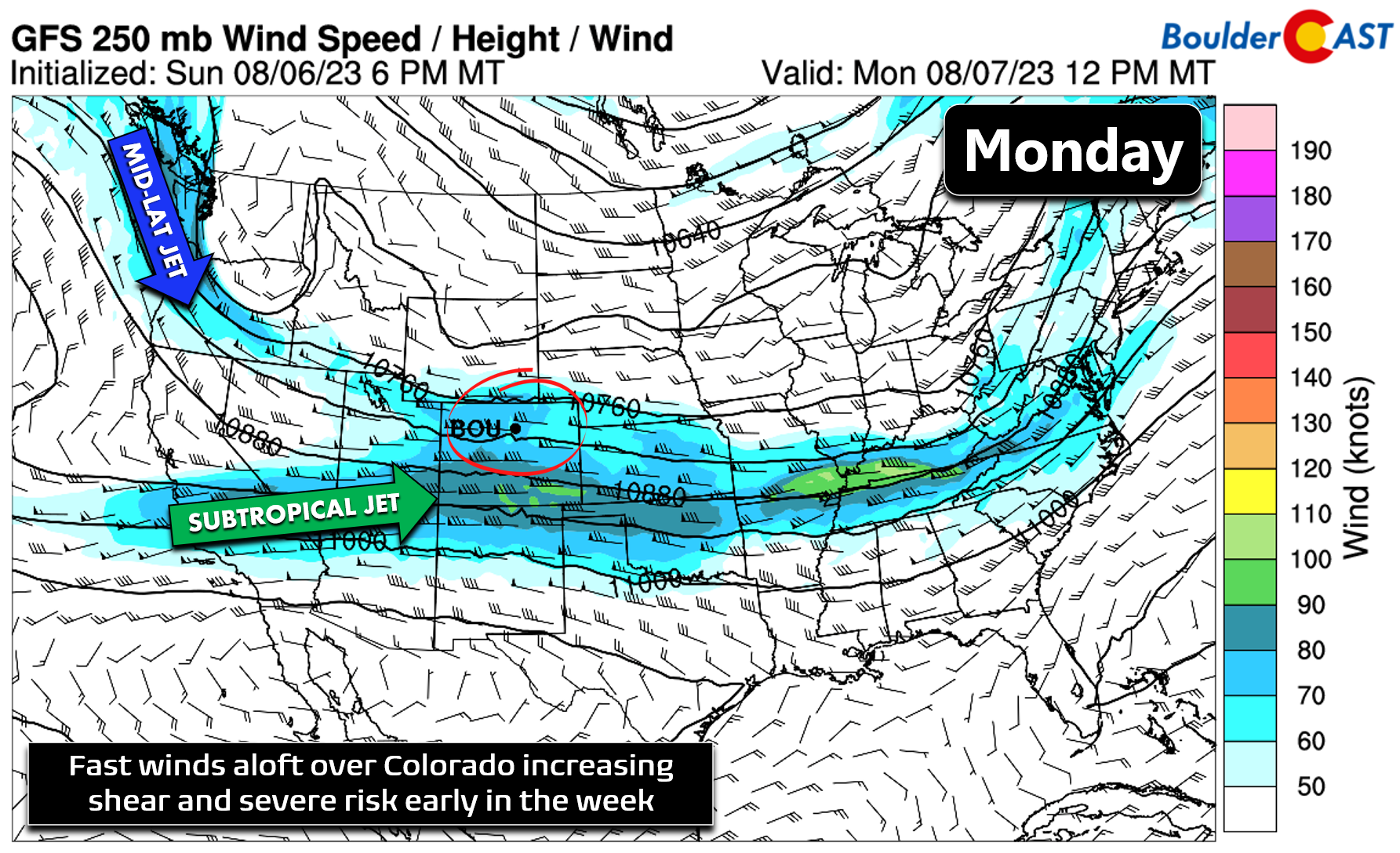
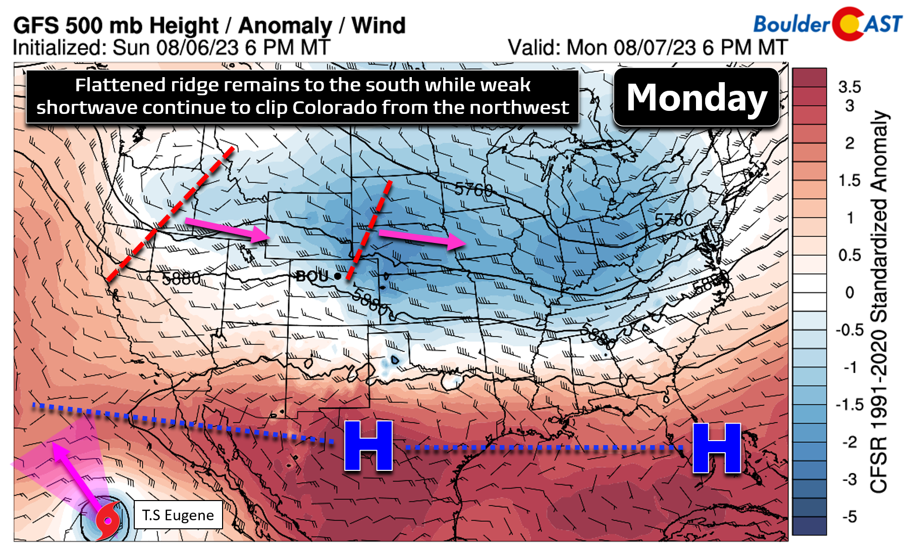
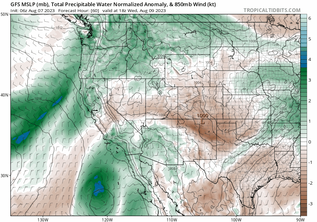
In addition, several embedded shortwaves will aid in overall lift and instability for the area. The large-scale pattern across the nation shows a highly flattened ridge present from coast to coast along the southern tier of the country (red shading). The central and northern part of the United States, including Colorado, remains in an active setup with weak troughing noted (blue shading). Several shortwave systems will progress from west to east in the flow across Colorado in the coming days helping just enough with afternoon thunderstorm development.
The Storm Prediction Center pinpoints eastern Colorado for a Slight Risk of severe thunderstorms on Monday, with eastern sections of the Denver Metro area at Marginal Risk.
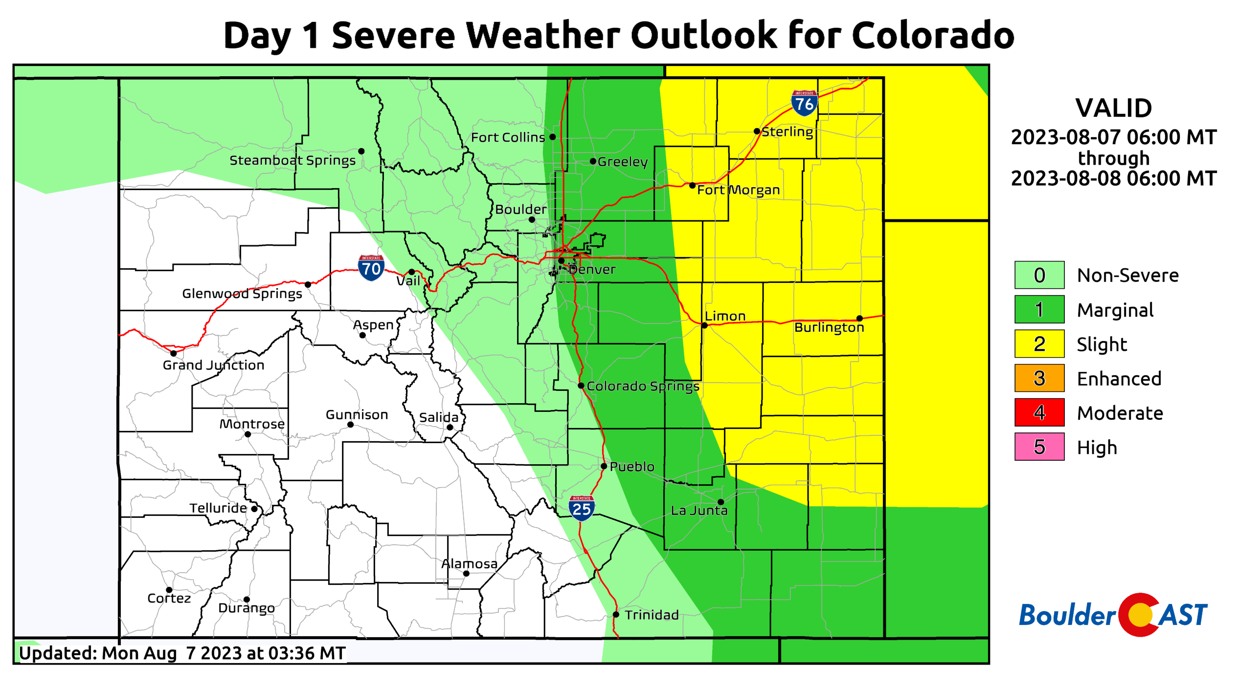
Monday Severe Outlook | SPC
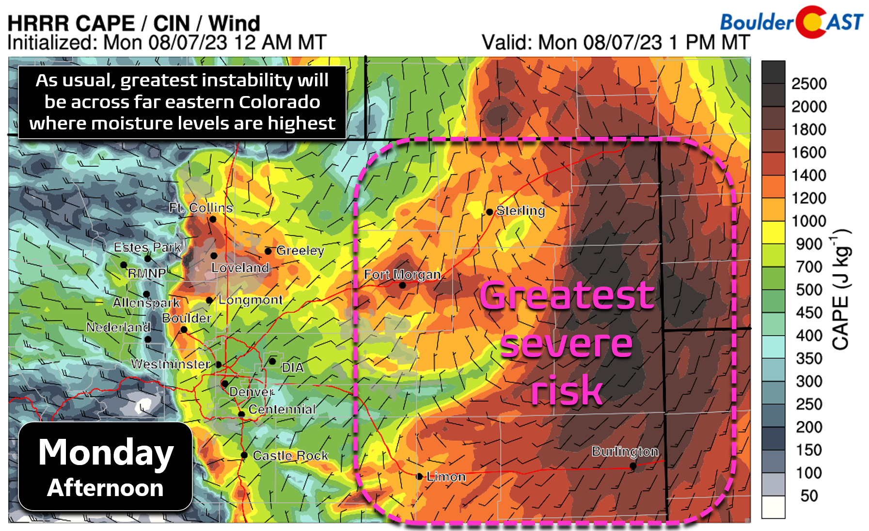
This placement lines up nicely with the CAPE (instability) distribution — 1000 to 2000+ J/kg of instability will exist across far eastern Colorado Monday afternoon. As usual, instability will be lower in the Front Range, but there will still be enough to catch a few weaker storms with a slight risk of severe weather in the afternoon and early evening. Hail up to 1.5″ in diameter is the main risk on Monday with the threat being highest east of Interstate 25.
On Tuesday the risk of severe weather remains for far eastern Colorado, but the Front Range specifically should be mostly in the clear. However, run of the mill showers and storms will be possible once again during the afternoon and evening under partly to mostly cloudy skies. Big hail is the primary risk associated with storms forming out across the northeast corner of the state on Tuesday as well.
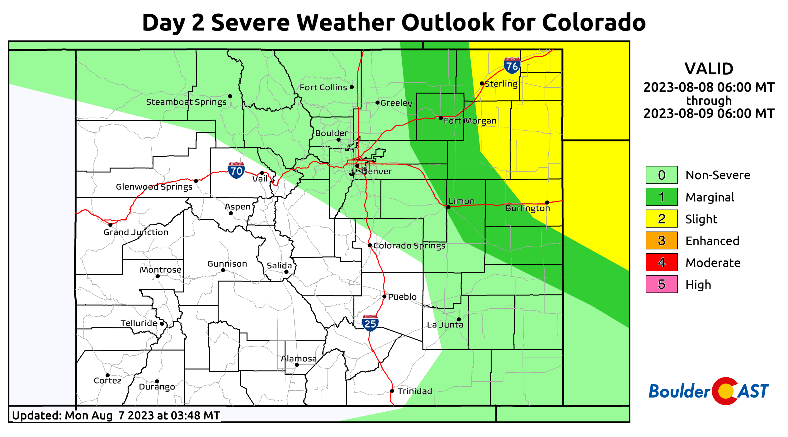
Tuesday Severe Outlook | SPC
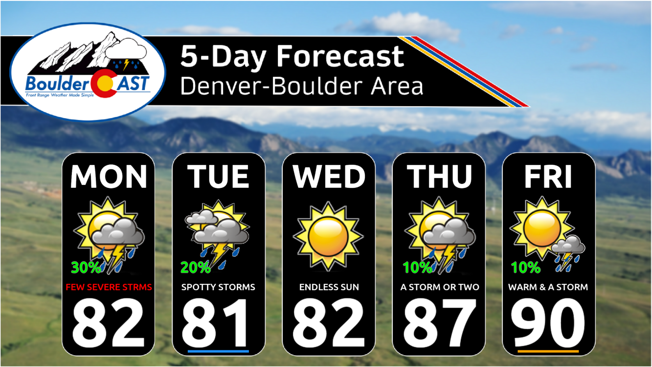
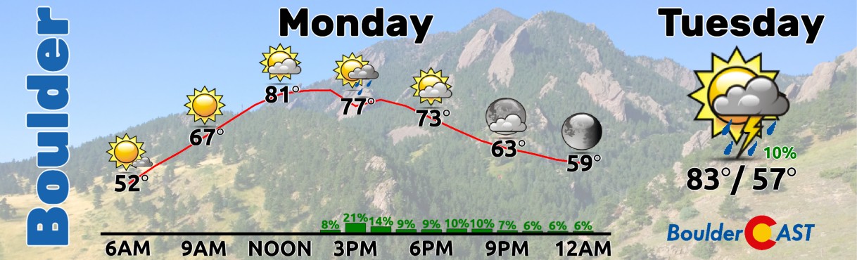
Both Monday and Tuesday will see highs in the lower 80s across the Boulder-Denver area with widely scattered late-day showers and storms.
As mentioned earlier, our average highs this time of year are still in the mid to upper 80s, so this week begins cooler than normal — something that has been all too familiar most of the summer thus far…
Drying out somewhat mid to late week
By Wednesday we start to turn a corner towards calmer weather as notably drier air infiltrates Colorado from the northwest. The primary shortwave departs into the Midwest leaving behind warm and dry air aloft over the region. Brief ridging will be present across the state as well which will translate into Wednesday being the only definitively dry day in our forecast this week.
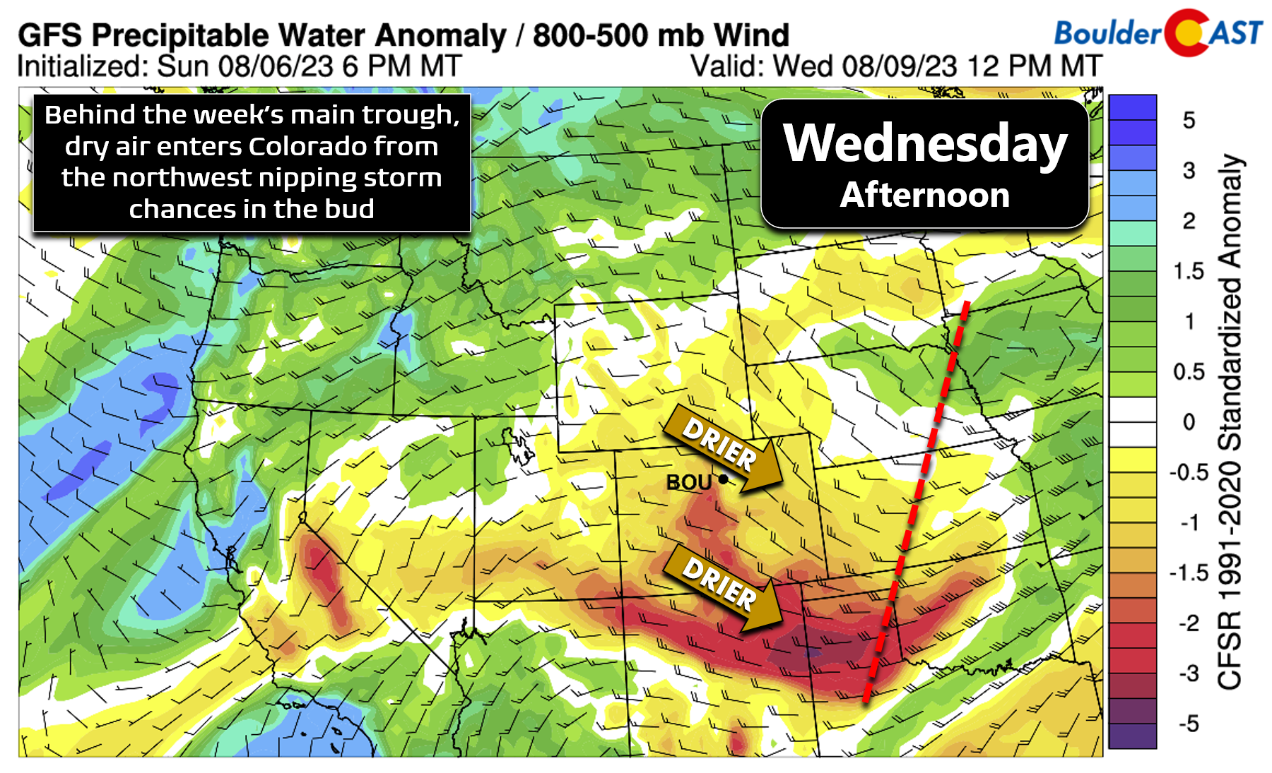
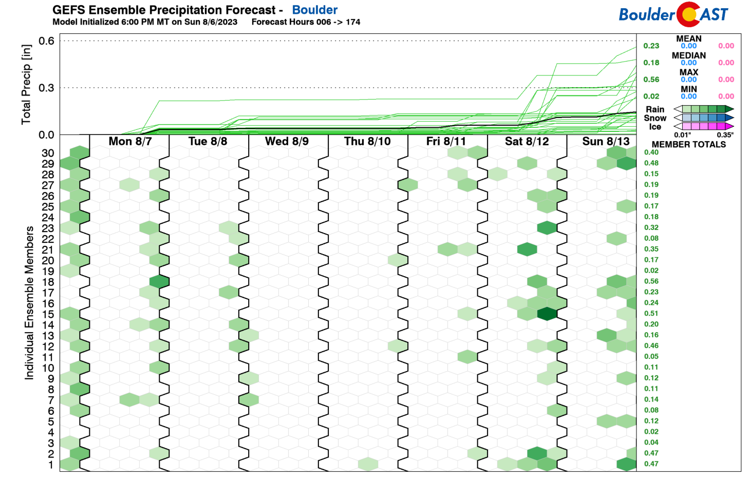
The jet stream will remain across the area at times through the rest of the week, but with limited moisture and lift to work with Wednesday and beyond, we should see mostly dry weather prevail into Thursday and Friday as well, though isolated storms may return to the forecast — particularly in the higher terrain. The GFS ensembles indicate just a spotty hint of storms popping up late week, with perhaps a further uptick for the upcoming weekend — more on that later.
Temperatures will begin to trend upwards during the backend of the week ahead, into the middle to upper 80s by Thursday and in the ballpark of 90 degrees come Friday. For now we’ll include just isolated (~10%) storm chances for the late-week days. Not a bad week overall really — at least once we clear the risk of severe storms on Monday!
Finally, you may have noticed that we have yet to mention the monsoon at all in this post — and that is because it is currently on a hiatus. The flattened yet potent ridge lingering along the Mexican border has obliterated the monsoonal flow into the Desert Southwest of late. This will finally change later this week as the ridge breaks down and the residual moisture from Tropical Storm Eugene advects in from the south. The forecast animation below is for moisture anomaly running from Wednesday through Sunday. Initially we see that very dry air over Colorado midweek. However, by the weekend the surge of subtropical (and even tropical) moisture spreads in from the south. This will fuel an uptick in stormy conditions across the Southwest and also into Colorado this weekend. It doesn’t appear to be a substantial surge though, so at this time we are not expecting any widespread flood risk. However, scattered monsoon storms likely make a return for both Saturday and Sunday across the Front Range.
Have a great week!
Forecast Specifics:
Monday: Partly cloudy with scattered thunderstorms developing during the afternoon and early evening. Storms could be strong to borderline severe, mainly east of Interstate 25, with hail up to 1.5″ in diameter possible. Highs reach the lower 80s on the Plains with upper 60s in the Foothills.
Tuesday: Partly to mostly cloudy with widely scattered showers and thunderstorms. Some storms will be severe well northeast of Denver. Temperatures top out around 80 degrees on the Plains with mid to upper 60s in the Foothills.
Wednesday: Very pleasant with sunny skies and temperatures remaining below normal in the lower 80s. No chance of rain. Highs reach the lower 70s in the Foothills.
Thursday: Increasing clouds with isolated late-day thunderstorms, mainly across the higher terrain. Temperatures warm up into the middle to upper 80s on the Plains with middle 70s in the Foothills.
Friday: Mostly sunny and warm with temperatures warming further towards 90 degrees on the Plains and towards the upper 70s in the Foothills. An isolated storm or two possible late in the day.
DISCLAIMER: This weekly outlook forecast is created Monday morning and covers the entire upcoming week. Accuracy will decrease as the week progresses as this post is NOT updated. To receive daily updated forecasts from our team, among many other perks, subscribe to BoulderCAST Premium.
Go Premium, get all the perks.
Daily Forecast Updates
Get our daily forecast discussion every morning delivered to your inbox.
All Our Model Data
Access to all our Colorado-centric high-resolution weather model graphics. Seriously — every one!
Ski & Hiking Forecasts
6-day forecasts for all the Colorado ski resorts, plus more than 120 hiking trails, including every 14er.
Smoke Forecasts
Wildfire smoke concentration predictions up to 72 hours into the future.
Exclusive Content
Weekend outlooks every Thursday, bonus storm updates, historical data and much more!
No Advertisements
Enjoy ad-free viewing on the entire site.
Get BoulderCAST updates delivered to your inbox:
Enjoy our content? Give it a share!


You must be logged in to post a comment.