This first major heatwave of 2023 will unfold this week across the Front Range as a broad ridge of high pressure produces bountiful sunshine and an influx of warm air from the southwest to Colorado. Multiple days of record high temperatures are expected as most of us soar into the 80s. However, late week a big cooldown is taking shape with rain/snow likely returning on Friday. Read on for all the details of the crazy weather week ahead.
This week’s highlights include:
- A strong ridge of high pressure will spawn a multi-day heatwave across the Front Range with plentiful sunshine as well
- Multiple days of record heat are likely in the Denver Metro with temperatures soaring into the 70s and 80s through Thursday
- Unseasonable warmth and sunny skies will accelerate snowmelt in the Mountains leading to increased runoff and declining ski conditions
- By late week a trough will move in bringing much colder temperatures and a chance of rain and snow for Friday — some accumulation is possible with this system
DISCLAIMER: This weekly outlook forecast is created Monday morning and covers the entire upcoming week. Accuracy will decrease as the week progresses as this post is NOT updated. To receive daily updated forecasts from our team, among many other perks, subscribe to BoulderCAST Premium.

Go Premium, get all the perks.
Daily Forecast Updates
Get our daily forecast discussion every morning delivered to your inbox.
All Our Model Data
Access to all our Colorado-centric high-resolution weather model graphics. Seriously — every one!
Ski & Hiking Forecasts
6-day forecasts for all the Colorado ski resorts, plus more than 120 hiking trails, including every 14er.
Smoke Forecasts
Wildfire smoke concentration predictions up to 72 hours into the future.
Exclusive Content
Weekend outlooks every Thursday, bonus storm updates, historical data and much more!
No Advertisements
Enjoy ad-free viewing on the entire site.
The first heatwave of 2023
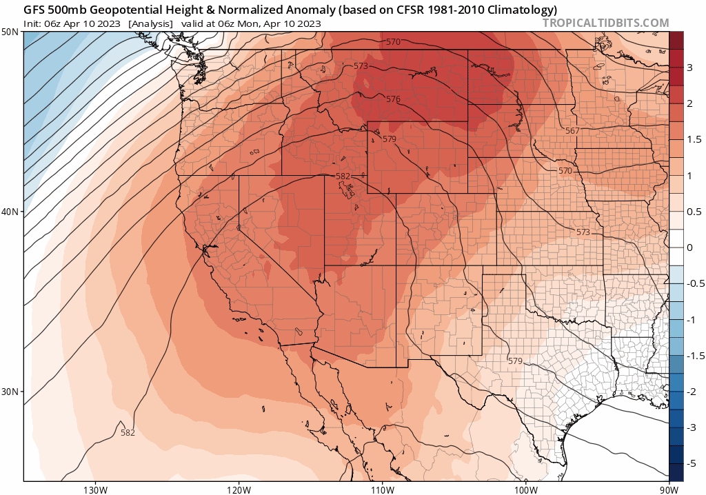
Our weather this week will largely be at the mercy of an intense and broad mid-level ridge of high pressure which will slowly migrate from the Desert Southwest on Monday into the Great Plains by Wednesday. This transition will shift our winds from northwesterly to southwestly and in the process generate a significant multi-day heatwave across the Front Range. Yes we are indeed using the “H” word in April! However, by late in the week, a trough entering by way of the Pacific Northwest is projected to reach Colorado forcing temperatures back below normal with rain/snow chances to follow. The GFS 500mb height anomaly forecast animation below shows both the intense ridge (red/orange shading) Monday through Wednesday and the arrival of the late-week trough (blue shading).
Plentiful sunshine and a quick shift to southwest flow will begin the warm-up for us immediately on Monday with highs reaching the middle 70s for much of the Denver Metro area under completely sunny skies. If you can believe it, Boulder has still not hit 70 degrees officially yet in 2023, a streak stretching back more than 160 days to early November. This streak definitely comes to an end on Monday with 70 degrees all but guaranteed for Boulder.
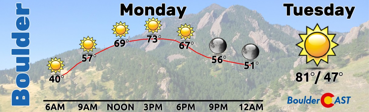
Though Wednesday, strong warming will continue over the area under broad southwest flow and with mostly sunny skies. Each day will see temperatures increase slightly at 700mb which will translate to progressively warmer conditions at the surface for us as well. Both Tuesday and Wednesday should top out in the low to middle 80s.

80-degree temperatures this time of year are overly common in the Front Range. In fact, our current forecast highs for both Tuesday (83°) and Wednesday (82°) are set to eclipse prior daily record highs in Boulder — the one on Wednesday was set 115 years ago in 1908!

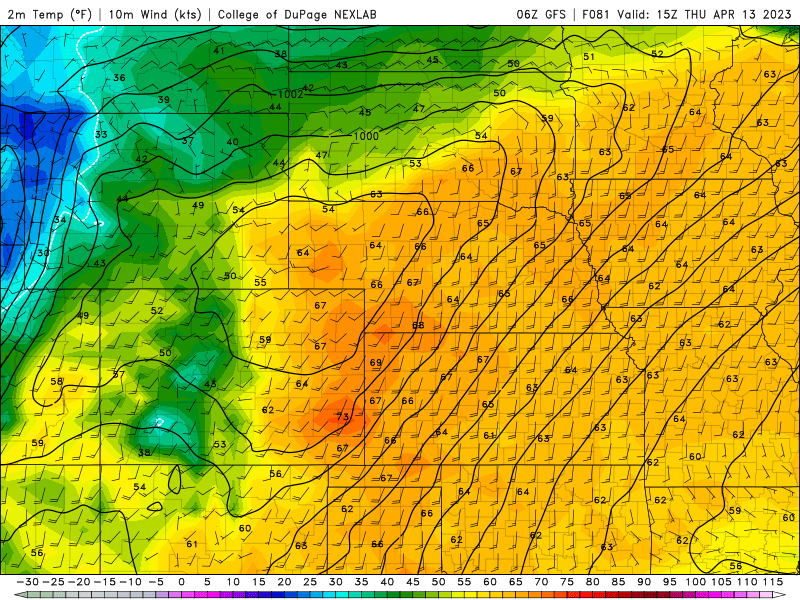
By Thursday, things will begin to change across the Front Range with a substantial influx of mid-level moisture into the area from the southwest ahead of the next storm system. While it still looks to be too dry at the surface to spawn any precipitation here, the widespread cloud cover will help to keep our temperatures slightly cooler on Thursday. While still well above normal, temperatures should drop back into the middle 70s for highs with overcast skies. Thursday will unfortunately be the last warm day of the week…more on that in a moment.

As this is the first major warm spell of 2023 and with Mountain snowpack substantially above normal statewide, we will likely see an uptick in runoff this week as some of the more vulnerable (i.e. lower elevation) snowpack begins to melt off. This will be accelerated through Wednesday afternoon as almost completely sunny skies will exist over Colorado. Currently the South Platte and Arkansas River Basins are sitting right around normal for snowpack, but a significant surplus is present across all of western Colorado. Don’t be surprised to see local creeks and rivers running higher than usual this week.

Much colder with rain/snow on Friday
As the aforementioned late-week trough moves into the central and northern Rockies, a cold front will drop through the Front Range from the north-northwest bringing much cooler temperatures and upslope to the area to close out the week. The current timing of the main cold front is late Thursday evening or Thursday night, though considering the four-day lead time, this could certainly shift a tad.
Low-level moisture will increase behind the front paving the way for not only colder temperatures but also a good chance of rain and snow on Friday. Temperatures generally look to be too warm for snow initially during the day, but by Friday evening and night we could see a transition over to snow across the lower elevations. Accumulations will depend on the ultimate track and timing of the storm, but a couple inches are currently favored in the Foothills and across the Palmer Divide — with mostly just a chilly rain or rain/snow mix in Boulder and Denver. As you can see below, the GFS ensemble mean and median precipitation forecast has more than one-half inch of liquid falling in Boulder between Friday and Saturday with a focus on the former.
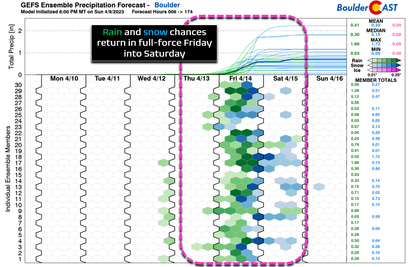
Overall, this pattern shift is definitely something to watch. For now, expect a much colder and gloomy end to the week with drizzle, fog, rain, snow, and overcast skies all on the table. High temperatures will tumble some 30 to 40 degrees back into the lower 40s to end the week — a far cry from the record-setting 80s in the days prior.
The upcoming weekend looks to remain on the cooler side with Saturday likely still being somewhat unsettled with minor rain/snow chances. Sunday should be dry but stays chilly.
Forecast Specifics:
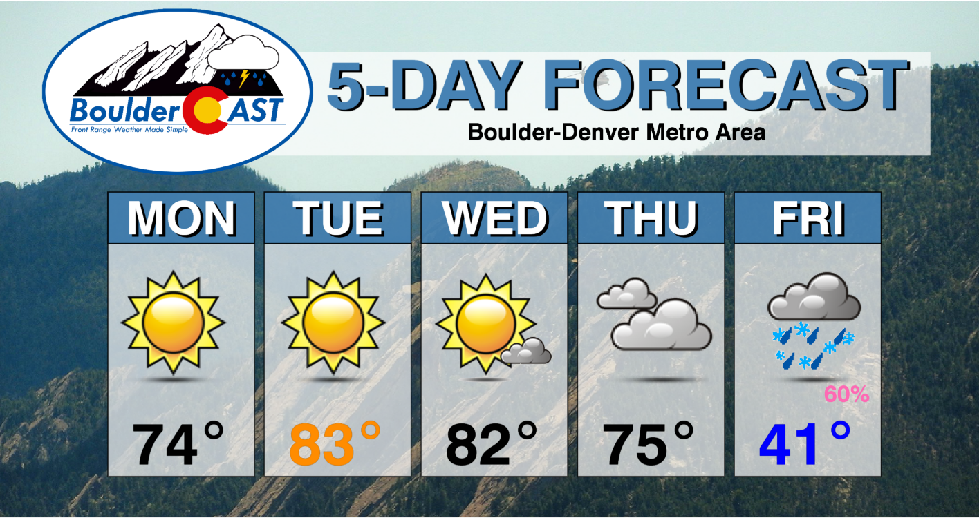
Monday: The epitome of a perfect weather day! Sunny skies and light winds with highs in the middle 70s on the Plains with lower 60s in the Foothills.
Tuesday: Continued full sunshine and much warmer with record highs likely across the Front Range. Temperatures skyrocket into the middle 80s on the Plains with lower 70s in the Foothills.
Wednesday: Record highs likely again. Sunshine early with clouds increasing through the afternoon and early evening. A few sprinkles are possible, mainly in the higher terrain, but most of what develops will evaporate before reaching the ground. Temperatures top out in the lower to middle 80s on the Plains with upper 60s in the Foothills.
Thursday: Plentiful mid and upper-level cloud cover will produce cooler temperatures for the area. A few isolated rain showers are possible in the higher terrain but still staying dry on the lower elevations. Highs reach the middle 70s on the Plains with lower 60s in the Foothills.
Friday: Much colder and cloudy with a good chance of drizzle, rain and/or a rain/snow mix through the day. Some snow accumulation may be possible Friday evening and night, especially for areas above 6000 feet elevation in the Foothills and Palmer Divide. Highs top out only in the upper 30s to middle 40s, with low to middle 30s in the Foothills.
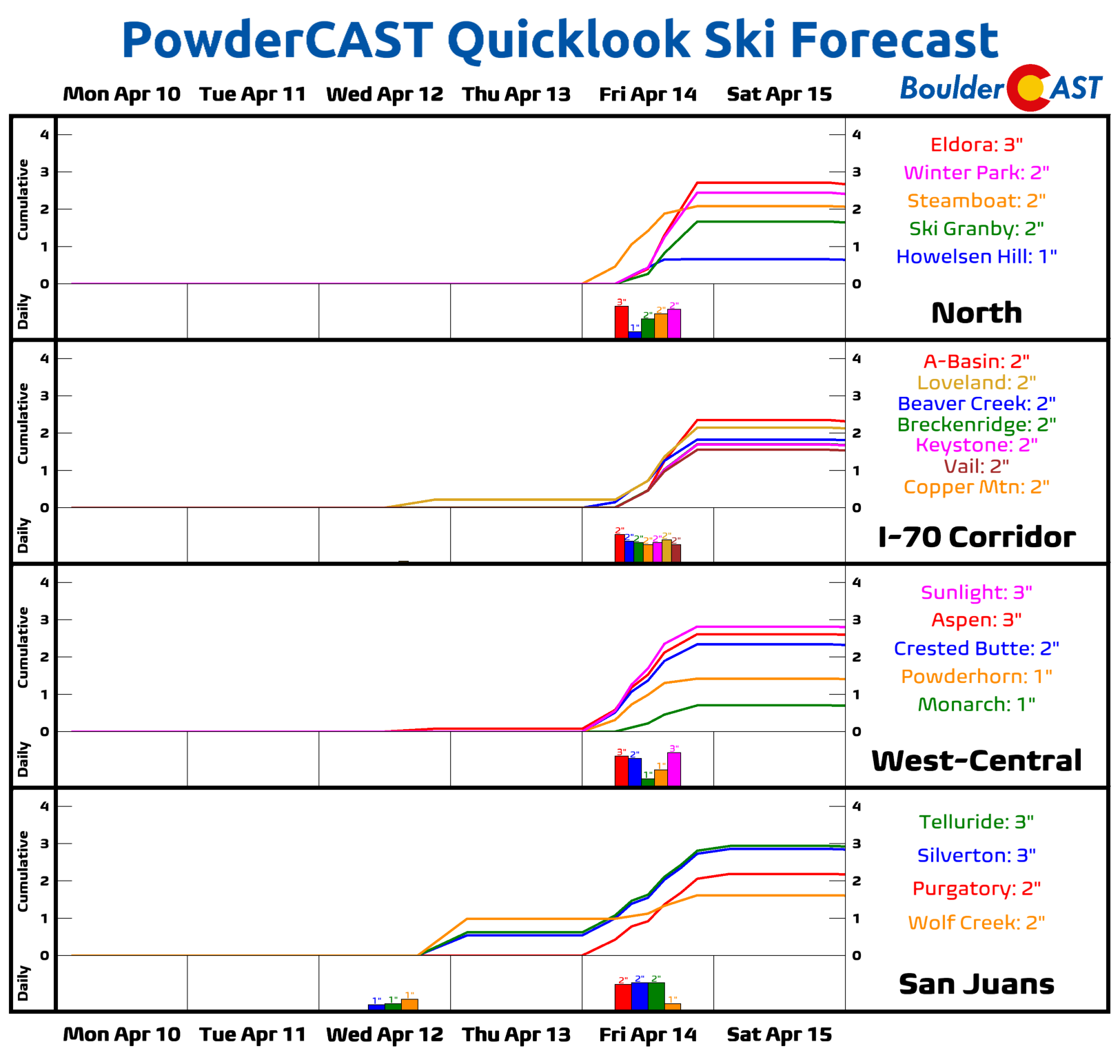
PowderCAST: Unseasonably warm temperatures and sunny skies will accelerate snowmelt across the Mountains this week with significant runoff expected. The late-week system could produce light accumulations of generally 1-5″ for most of the ranges statewide. Overall the powder outlook for the Mountains looks bleak with any resorts still open expecting worsening ski conditions.
DISCLAIMER: This weekly outlook forecast is created Monday morning and covers the entire upcoming week. Accuracy will decrease as the week progresses as this post is NOT updated. To receive daily updated forecasts from our team, among many other perks, subscribe to BoulderCAST Premium.
Go Premium, get all the perks.
Daily Forecast Updates
Get our daily forecast discussion every morning delivered to your inbox.
All Our Model Data
Access to all our Colorado-centric high-resolution weather model graphics. Seriously — every one!
Ski & Hiking Forecasts
6-day forecasts for all the Colorado ski resorts, plus more than 120 hiking trails, including every 14er.
Smoke Forecasts
Wildfire smoke concentration predictions up to 72 hours into the future.
Exclusive Content
Weekend outlooks every Thursday, bonus storm updates, historical data and much more!
No Advertisements
Enjoy ad-free viewing on the entire site.
Spread the word, share the BoulderCAST forecast!


You must be logged in to post a comment.