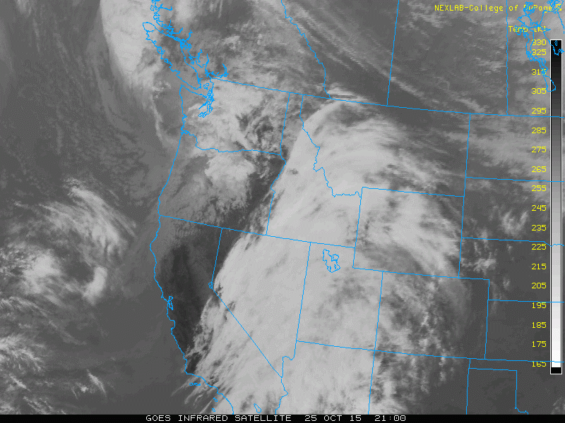
After a very tranquil and mild weekend with temperatures in the upper 60’s, this week’s weather will be cooler and more seasonal. We start off the week under cloudy skies due to an upper level system in the Pacific Northwest. The pattern then turns more active late in the week, with even the potential for a few snowflakes. Continue reading for all the details!
Last week’s weather system dumped our most significant rainfall since mid-May. Nearly all of Boulder County received more than 1.5″ of precipitation, with Boulder officially picking up 1.67″ of rain, while 1.75″ was recorded at BoulderCAST Station. Shown below are radar estimated precipitation totals for the event.
A few inches of wet snow were recorded in the higher Foothills, and a wintery 6-12″ fell in the highest elevations, including Vail and Berthoud Pass. With that, let’s check out the forecast for the upcoming week.
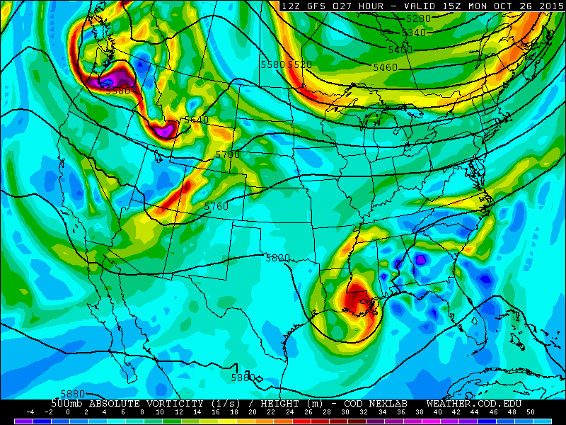
This week’s forecast will focus on a series of low pressure systems coming out of the Eastern Pacific, as well as from Canada. Below shows the 500 mb absolute vorticity and heights from the GFS model for today. The area of low pressure is centered over Washington State, with waves of energy extending southeastward of this main system over Idaho, Wyoming, and western Colorado.
This system is responsible for producing the mid and high-level clouds across Boulder County today and this evening. These clouds are evident in the GFS model when looking at 500 mb relative humidity, with values in Colorado over 90%.
Temperatures will be cooler today compared to Sunday, reaching into the low 60’s. In the mountains west of the Divide, light snow showers will be possible above 9,500 feet with the shortwave advancing from west to east. Over Boulder County, a few isolated showers are possible through the day, but most of us will stay dry.
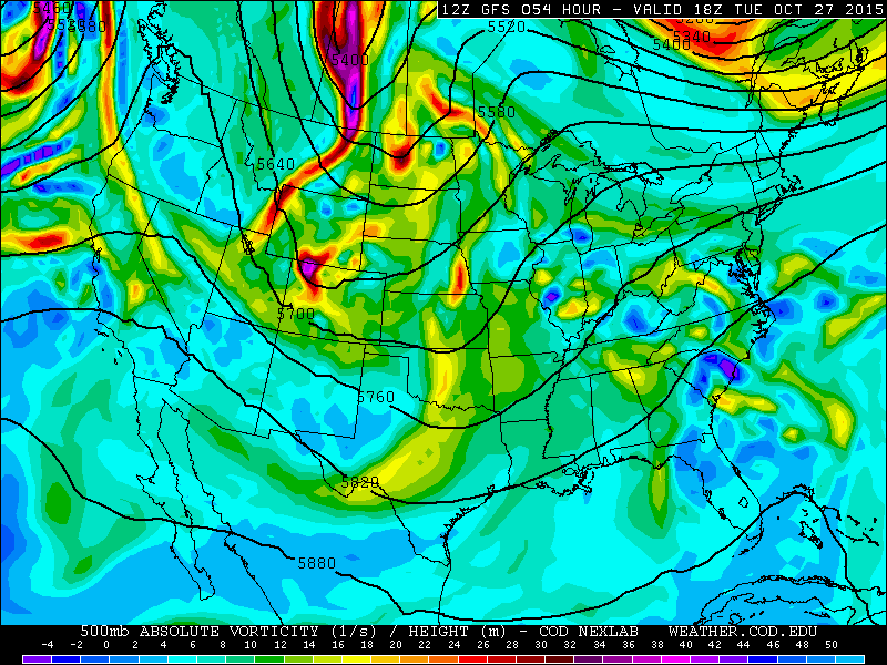
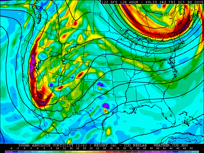
Heading into Tuesday, the upper-level jet stream makes a dive southward from Canada. Below is the forecast at 500 mb from the GFS model. It shows strong area of low pressure diving south out of Saskatchewan. Well ahead of this system, shortwaves dig southward out of Wyoming and reach northwestern Colorado in the afternoon tomorrow. This pattern will help advance a fast moving cold front by mid to late afternoon on Tuesday across Boulder County. Behind the front, colder air will take over and breezy conditions will be likely Tuesday night. Temperatures will only reach into the upper 50’s on the Plains before the front passes. A lack of moisture with this system will keep Boulder County dry for the most part, but a few scattered showers are possible in the early evening with the initial frontal passage.
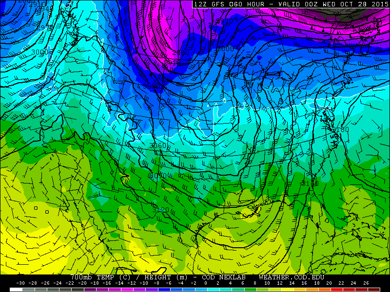
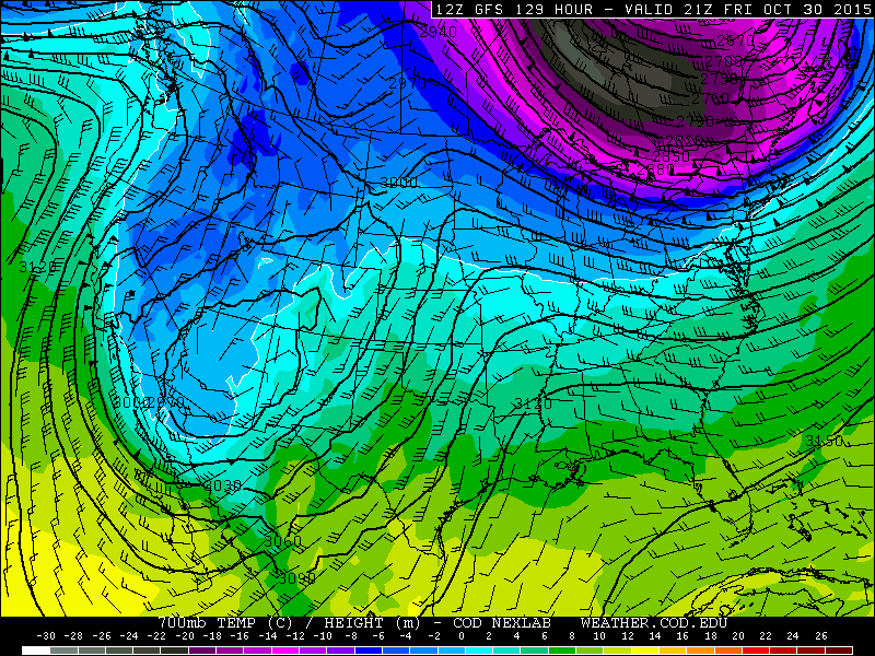
This 500 mb-level pattern indicates a northwesterly flow aloft with upper level divergence favorable for lift across the northwest facing mountain slopes over Colorado. 700 mb temperatures, given below, also indicate colder air, with snow levels likely dropping to 8,000 feet. As a result, snow showers will take place over northwestern Colorado and west of the Divide, with Steamboat being the favored area, with 2-4″ possible by Tuesday night.
Heading into Wednesday, temperatures in Boulder County will rebound back into the low 60’s on the Plains. The majority of the cooler air will impact areas to our east over Kansas and the Midwest, as the strong upper-low diving south out of Canada centers over the Dakotas and Minnesota. Expect lots of sunshine on Wednesday.
As we go into Thursday, Boulder will be in between weather systems. The upper-low over the Midwest (shown below) will be off to our east. At the same time, another trough will push into the Pacific Northwest Wednesday and move south across California on Thursday, causing an increase in clouds for our region. Expect dry conditions with temperatures in the upper 50’s on the Plains.
The forecast turns more active Friday and for the upcoming weekend, just in time for Halloween! Below shows the GFS forecast for Friday, indicating a very strong and deep area of low pressure over Baja and southern Arizona midday Friday. Ahead of this large system, waves of energy eject northeast into New Mexico and Colorado. This will likely produce snow showers in the Mountains of southwestern Colorado. for our region, this system looks to be just a little too far south to impact us on Friday, so expect mostly dry conditions for now. However, there will be lots of clouds, especially in the afternoon. Northeasterly flow will ensue across the Plains on Friday due to this system, and as a result, temperatures will turn colder in the lower 50’s for highs to end the week.
In the extended outlook over Halloween weekend, the weather turns interesting for the trick-or-treaters…
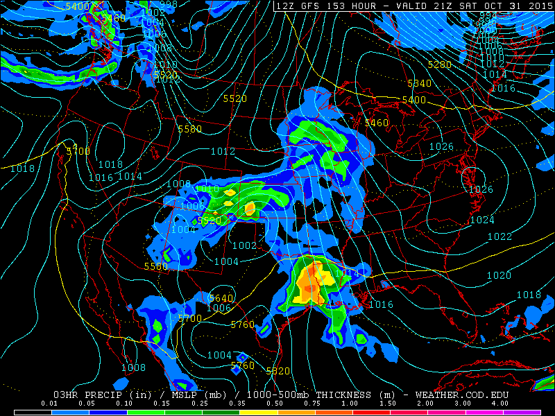
The large upper-level low pressure system discussed earlier will move into southeastern Colorado Saturday night. Right now, the track of this system moves a little too far south to impact Boulder County. However, as you can see on the forecasted precipitation from the GFS model for Saturday, the precipitation reaches as far north as southern Denver. This means the exact track of the system will be key on whether Boulder sees precipitation on Saturday or not. Temperatures appear to be cold enough for a mix of rain and snow, so it is possible we could see our first flakes this weekend. Right now, though, the track favors southeastern Colorado. We will keep you up to date if things change later in the week though!
The Forecast:
Monday: Mostly cloudy skies with scattered light showers in the Foothills and only an isolated shower on the Plains. Highs cooler in the low 60’s on the Plains and mid 50’s in the Foothills.
Tuesday: Sunny skies with highs in the upper 50’s across the Plains and middle 50’s in the Foothills. Turning breezy and cloudy later in the afternoon and evening, with a few scattered showers, breezy northerly winds at 20-30 mph.
Wednesday: Lots of sunshine. High temperatures a little warmer. Low 60’s on the Plains with middle 50’s in the Foothills.
Thursday: Sunny skies giving way to increasing afternoon high clouds. Highs in the upper 50’s across the Plains, with mid 50’s over the Foothills.
Friday: Partly sunny skies becoming mostly cloudy in the afternoon. Isolated showers are possible, mostly south of Denver. Highs much cooler in the lower 50’s for the Plains and Foothills.
High Country Forecast:
Light rain and snow showers across western Colorado Monday and Monday evening with snow levels above 9,500 feet. Snow showers again likely Tuesday and Tuesday night across northwestern Colorado with snow levels dropping to 8,000 ft. Drier conditions Wednesday and Thursday, with more snow showers across southwestern Colorado Friday and Saturday. At this point, the Front Range looks to be the loser for the week.
Extended Outlook:
A large trough of low pressure ejecting out of the southwestern United States over the weekend will result in colder weather with upslope flow, as well as the potential for our season’s first snowfall Saturday night. Right now, though, the system looks to stay south of Boulder, with below normal temperatures over the upcoming weekend.
Source
Mon
Tue
Wed
Thu
Fri


BoulderCAST
62
60
63
59
52


NWS
60
59
58
54
54


AccuWeather
62
62
64
59
53


The Weather Channel
60
58
63
57
50
Last week’s recap:
Here are the results of last week’s forecast. First, the forecasts and observations:
Last week started warm, but things went downhill quick with the arrival of a potent storm system Tuesday evening. BoulderCAST mentioned rain persisting from Tuesday evening into Friday morning. Rain was recorded each day that it was forecast.
Now the error analysis. Shown is the amount of degrees (in Fahrenheit) that each source was off from the mean observed temperature for Boulder. Positive values indicate the forecast was warmer than what actually occurred, while negative values arise from a forecast that was cooler than what was observed.
The trickiest forecast for the week ended up being Thursday. If you recall, we mentioned that would be the troublesome day, since models were diverging on what would happen. Rain and low clouds were more extensive on Thursday than expected, keeping temperatures in the 40’s (9 degrees below forecast).
The bottom row of the error table shows the weekly mean error for each weather outlet, a good measure for who was the best and more consistent “forecaster” for the week. BoulderCAST has returned to first place, having just 3.0 degrees of mean error, including taking best forecast three days of the week (Tues, Wed, and Fri). In last, once again, is the NWS.
—
If you haven’t already done so, follow us on Twitter or Facebook for frequent weather updates and subscribe to the site to get these posts automatically delivered to your email box (enter your email in the sidebar widget to right).






You must be logged in to post a comment.