One of the most widespread Front Range severe weather outbreaks in recent memory is taking shape on Wednesday, though we still have some concerns. Two-inch hail, damaging winds and a few tornadoes are likely across eastern Colorado on Wednesday. Before that however, there will be another more uncertain bout of severe weather Tuesday night for the northern Front Range with big hail the main concern. Let’s get into this two-folded complex forecast!
At a Glance:
- A somewhat uncertain setup may spawn severe thunderstorms Tuesday night north of Denver between 9PM and 3AM — big hail is the primary concern!
- A more widespread wallop of severe storms are expected Wednesday afternoon for essentially the entire Front Range, including the higher terrain
- Wednesday could be one of the most notable severe weather outbreaks in our area in perhaps 5 to 10 years
- Large hail (2″+), damaging winds and a few tornadoes are expected across eastern Colorado Wednesday
- We still have some lingering concerns regarding morning low clouds spoiling the party somewhat, as well as a potential Denver Cyclone interfering
- A round of upslope rain will follow the severe weather Thursday into Friday— most areas should see 1″+ of rain by the end of the week, much more if you believe the Euro!
T
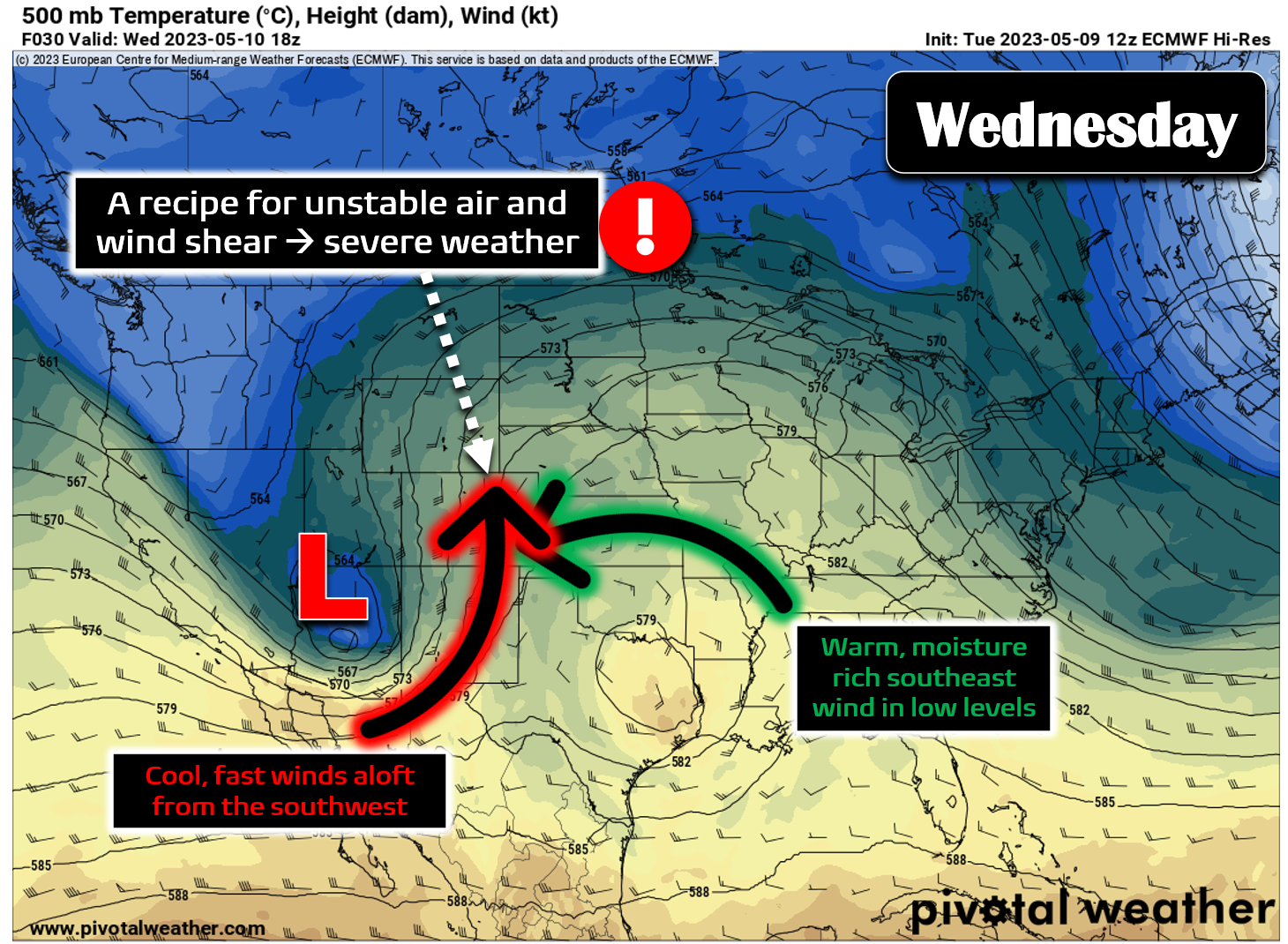
he large-scale weather pattern taking shape for this week filled our team with great anticipation! This time of year, we always keep a lookout for deep troughs coming east out of the Rockies as they create the ideal setup for severe weather across the country. Cool and fast winds wrapping around the base of the trough aloft mingle with the warm and moist low-level easterly winds near ground level resulting in the perfect mix of unstable air and wind shear — the two primary ingredients needed for explosive severe thunderstorms.
Despite the destruction severe weather can cause, it is exciting to forecast it, chase it around like idiots and to help the community prepare for it. Our weekly outlook on Monday included a stern warning that Wednesday was likely to entertain a significant risk for severe weather in our area — and well… here we are with an update!
We’ll start with the massive severe thunderstorm complex currently carving a path of (mainly wind) destruction across Kansas. The outflow of cool and moist air from this behemoth will play a critical role in seeding the Front Range severe threat on Wednesday, and probably even sooner than that!
Keep an eye on the severe weather ongoing in Kansas right now as the cool/moist outflow from this storm complex will reach the Front Range tonight and help set the stage for our severe storms tomorrow! 💣💥#COWx pic.twitter.com/rNLJbiLyiP
— BoulderCAST Weather (@BoulderCAST) May 9, 2023
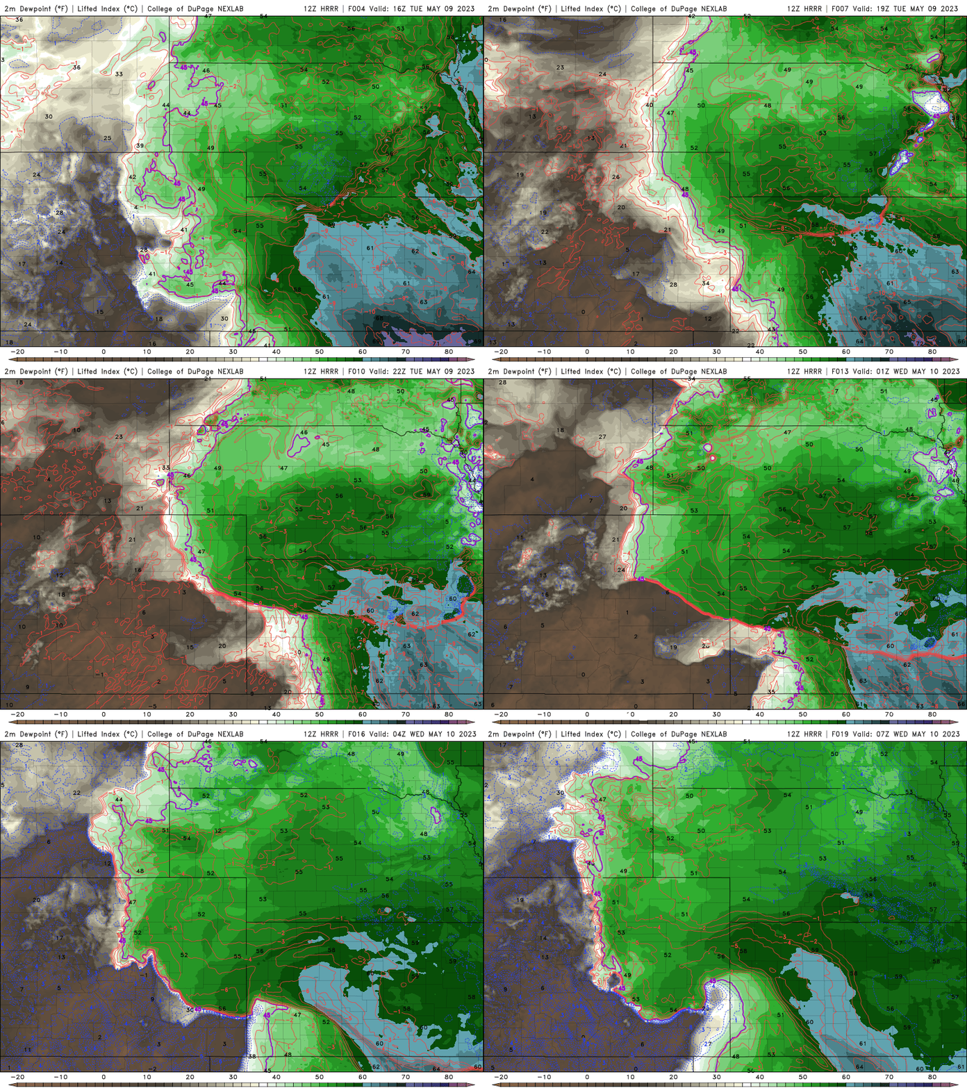
It may not seem intuitive that a batch of thunderstorms some 300 miles away in Kansas could be impactful to our weather, but that is the case in dicey situations such as this. The massive pool of rain-cooled air surging outward from those storms will race into eastern Colorado Tuesday evening. This is shown in the forecast for surface dew points below.
This boundary is projected to fire off additional storms as it moves this way along I-70 towards us. The wall of moist air will eventually surge into the Denver Metro area late Tuesday evening, ultimately banking up against the Foothills. Because of the fast/cooler winds aloft, this moist air could turn a run-of-the-mill quiet spring evening into one with severe storms in the Boulder-Denver area if the capping inversion can be overcome. Here’s a closer look at the low-level moisture rushing into eastern Colorado Tuesday evening via the HRRR model forecast:
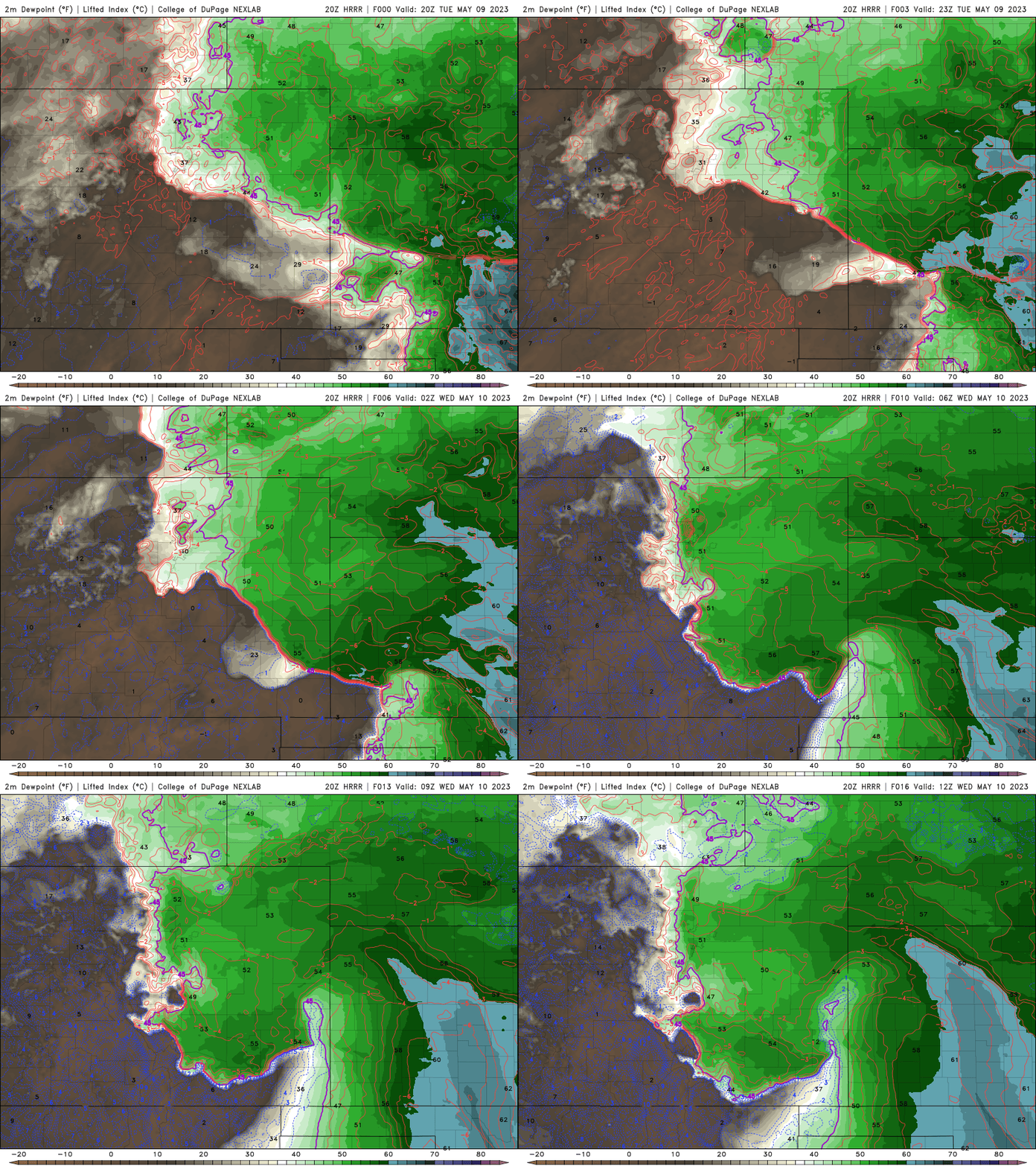
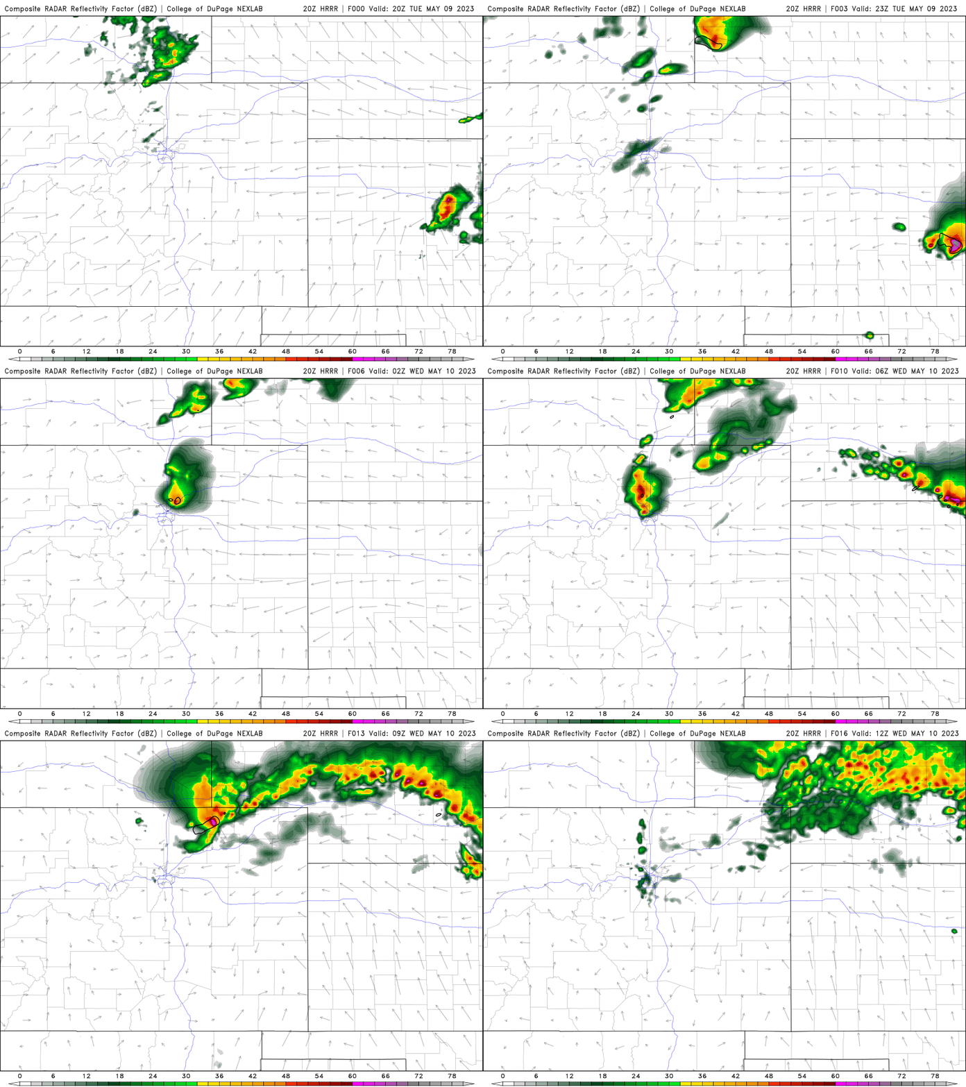
And below is the resulting explosion of strong to severe thunderstorms over the I-25 Corridor from Denver to Cheyenne Tuesday night between 7PM and 4AM. It’s important to remember that this is just a model forecast. The situation is definitely somewhat uncertain given the heavy reliance on that fine-scale boundary of moisture to arrive and play along. The instability and resulting severe storms are not guaranteed to occur, but we have a growing suspicion that they will! We’ve seen plenty of times like this where nothing happens, but equally as many ones where Mother Nature brings out the big guns. The greatest risk area tonight is between Boulder, Fort Collins, and Greeley where the best chance of popping the cap seems to be. The timeframe for the greatest risk is 9PM to 3AM, but that isn’t a definitive window! Big hail 1 to 2″ in diameter and 60MPH wind gusts could occur in these storms Tuesday night — the hail being the more likely inclusion. Keep an eye to the sky and stay connected in case something potentially dangerous to life or property does materialize!
Regardless of what unfolds Tuesday night, the severe weather risk on Wednesday is a somewhat easier forecast, if there really is such a thing! In fact, Wednesday is shaping up to be one of the highest risks for severe weather in the Boulder-Denver area in many years, possibly since the fateful day back in June 2015 that spawned a rare F3 tornado and bountiful 2″+ hailstones. Wednesday’s setup has all the hallmarks of a severe weather outbreak in our area:
- A mid-level trough moving in from the west with moderately strong winds from the south or southwest
- Shallow easterly flow supporting a pool of low-level moisture banked up against the Foothills. Often this is sourced by the prior day’s convection in Kansas or Nebraska.
- Bonus lift from the approaching trough and jet stream, as well as the shallow upslope
- Instability near climatological records for our area
- A possible Denver Cyclone low-level wind setup to help focus the initial convection
- Plentiful sunshine to bake the cake!
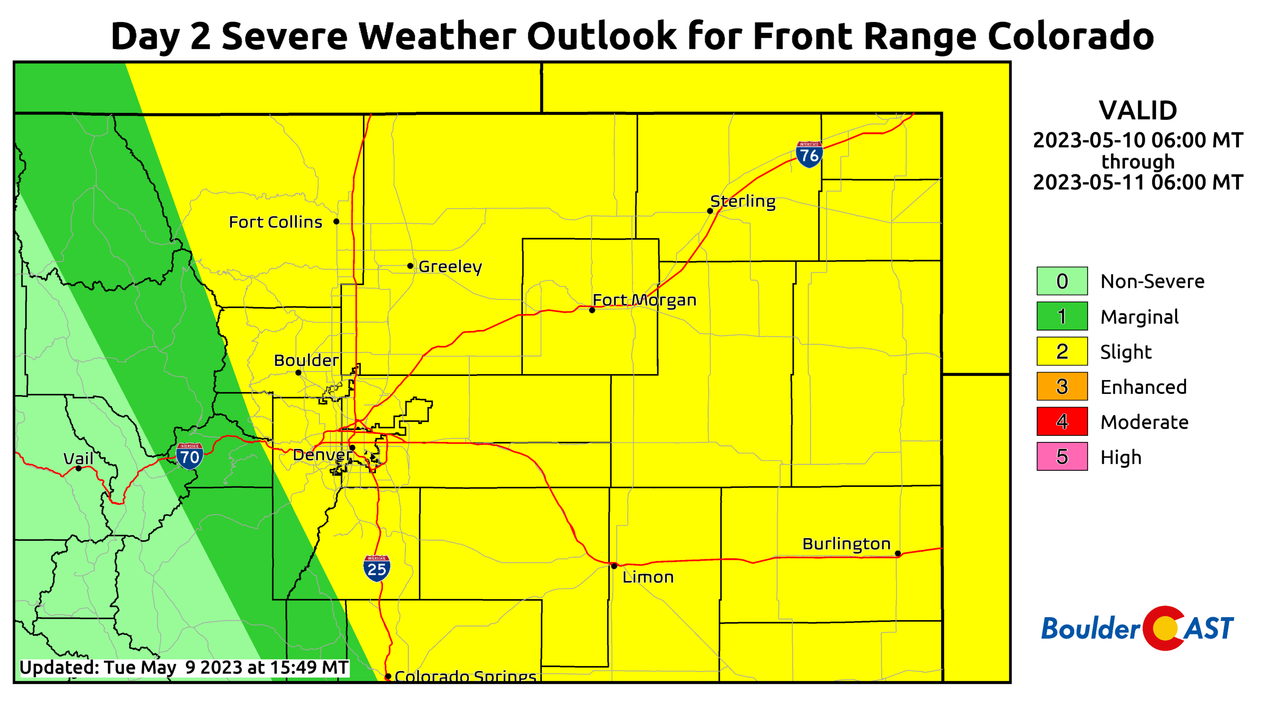
In response to the growing concern for an outbreak, the Storm Prediction Center has slowly been expanding their categorical “Slight Risk” outlook westward the last day or two. Their latest yellow polygon now includes Boulder, the Foothills and even Boulder County’s own 14er — Longs Peak! This is an extremely rare occurrence to have this level of risk this far westward. We really can’t remember seeing it this far west in the last decade or more (and yes, please correct us in the comments if that is not accurate!).
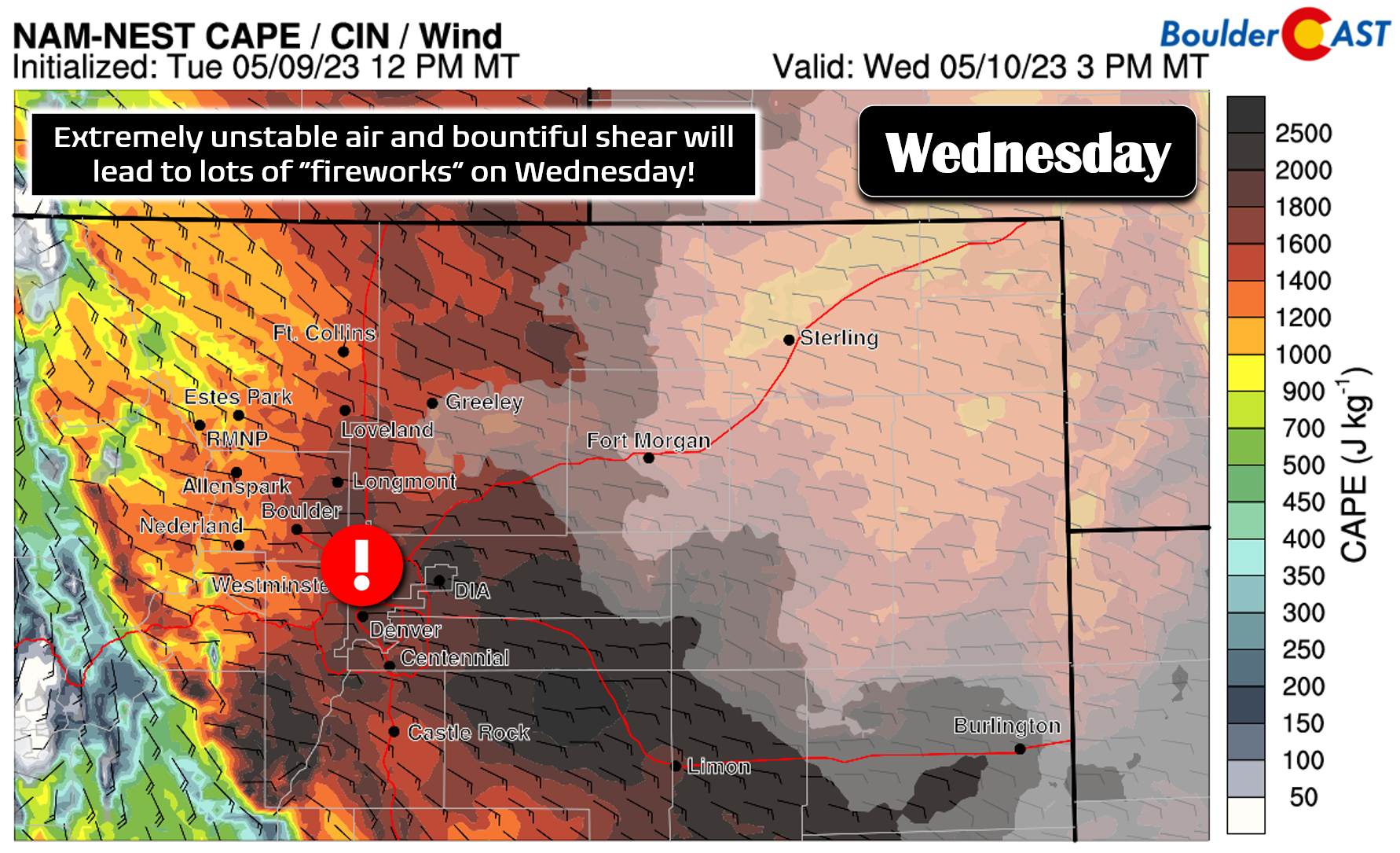
Wednesday’s action will be fast and furious across much of eastern Colorado as the residual moisture that arrived under the cover of darkness sticks around to fuel Wednesday’s happenings. Instability will be “off the charts”, at least by arid Front Range standards, exceeding 1500 J/kg by early afternoon Wednesday in our area.
Storms are expected to rapidly develop over the Mountains and Foothills by midday and move north-northeast through the afternoon and evening. Initially we expect to see lots of discrete supercell development up and down the Front Range, including over the Foothills which doesn’t happen very often. However, storms should cluster and grow as they head off to the northeast through the afternoon and evening. The main threats on Wednesday will be very large hail and damaging winds, though there will likely be a couple tornadoes mixed in as well. Anywhere east of the Continental Divide is at risk on Wednesday. If you are reading this, that probably means YOU!
We do have some concerns about the setup on Wednesday, though. Severe weather is always a tricky sell here in the Denver area with Mother Nature never cooperating fully. That’s why it is so rare to see this magnitude of outbreak here. Moisture is critical for any such outbreak as this, but it will also bring its challenges in the form of potential low cloud development early Wednesday (especially in and near the Foothills). Too many low clouds would limit the warm-up and cut into instability and thus the entire event as a whole. It does look like there will be some low clouds forming early Wednesday morning, especially west of I-25 and around Boulder. It’s hard to say exactly if this will happen given the poor job models have already done handling the moisture pool, but it seems probable. There’s also a risk that a developing Denver Cyclone could pull in drier air south and southwest of Denver. Eventually that will happen anyways, but we don’t want it to happen too soon as it will sweep the instability away to the northeast. Furthermore, a good chunk of the forecast for Wednesday could depend on how the moisture is redistributed around following the potential severe storms Tuesday night. All in all, that promised easy forecast for Wednesday is once again looking to be anything but!
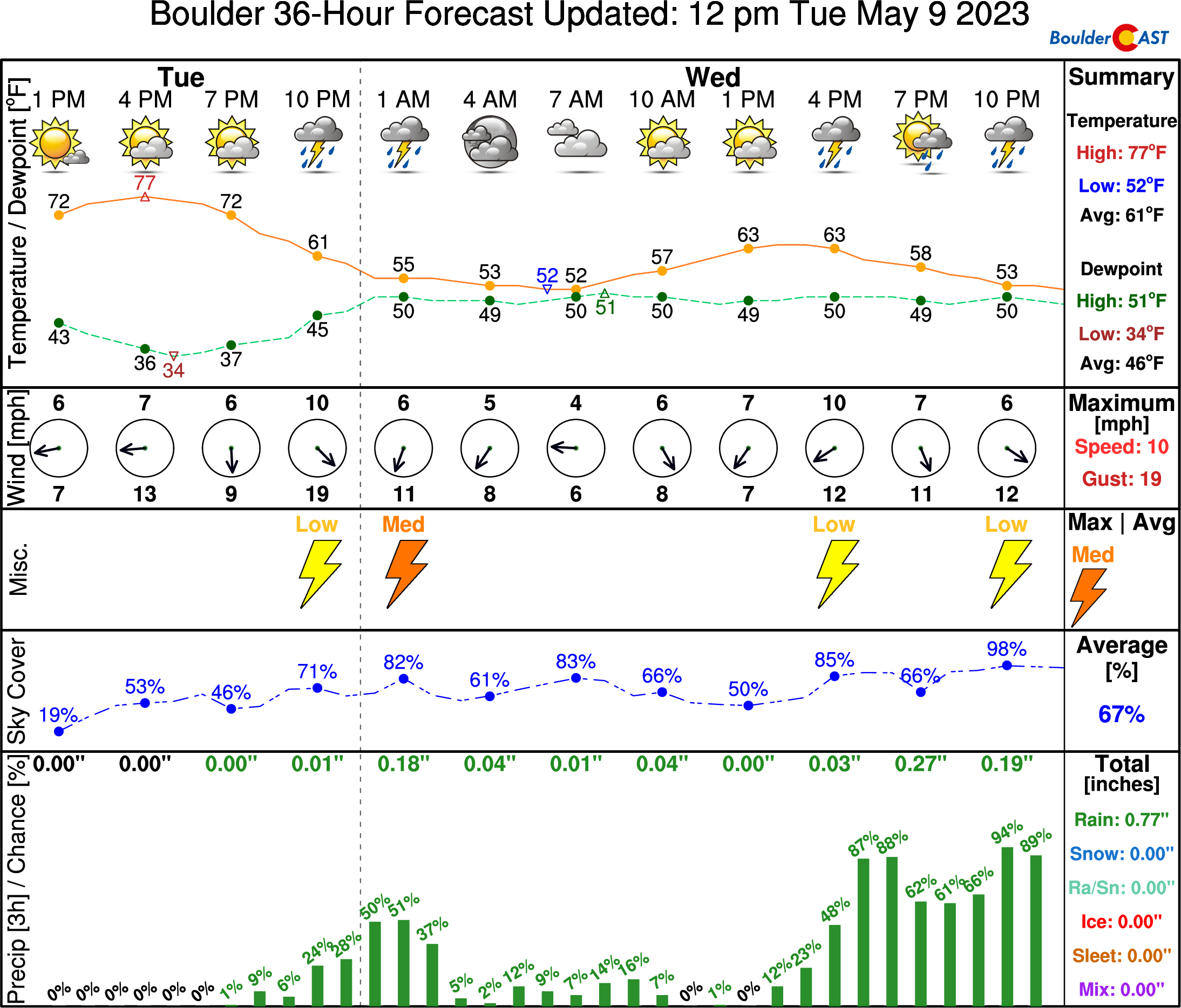
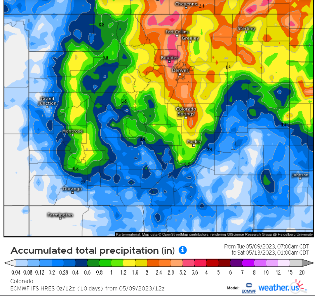
Outside of the severe weather risk, everyone should see a decent soaking of rain in the coming days — whether it be from the severe thunderstorms Tuesday night and Wednesday, or the encore of upslope rains Thursday and Friday from the parent low pressure which kicks out in the High Plains. Anything less than 1″ of rain this week would be a disappointment in our book. If the bullish Euro model is to be believed, we could end up with A LOT more than that:
That’s all for now. Please be weather aware BOTH late Tuesday night and Wednesday afternoon! We’ll be back with an updated Premium forecast discussion Wednesday morning. By then we are hoping to see better model consensus and pinpoint the highest at-risk areas and timing for Round #2. Stay safe!
Daily Forecast Updates
Get our daily forecast discussion every morning delivered to your inbox.
All Our Model Data
Access to all our Colorado-centric high-resolution weather model graphics. Seriously — every one!
Ski & Hiking Forecasts
6-day forecasts for all the Colorado ski resorts, plus more than 120 hiking trails, including every 14er.
Smoke Forecasts
Wildfire smoke concentration predictions up to 72 hours into the future.
Exclusive Content
Weekend outlooks every Thursday, bonus storm updates, historical data and much more!
No Advertisements
Enjoy ad-free viewing on the entire site.
Get BoulderCAST updates delivered to your inbox:
Enjoy our content? Give it a share!



You must be logged in to post a comment.