After a stretch of crisp, dry days to end the week, our weather is gearing up for a big warm-up this weekend, with near-record highs favored by Sunday. This developing warm and unfortunately dry pattern looks likely to stick around well into November. With each passing day, the odds grow that Boulder might challenge its record for the latest first snowfall.
At a Glance:
- Cool and Dry Through Friday: Northwest flow keeps Boulder crisp with highs in the 40s–50s to end the week.
- Halloween Outlook: Cloudy during the day but clearing skies towards sunset. Expect a chilly evening in the 40s to upper 30s, but dry and calm—great trick-or-treating weather for late October.
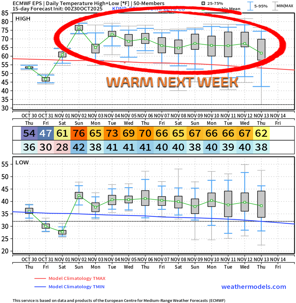
- Weekend Warm-Up: A strong ridge builds in, pushing highs to the low 60s Saturday and mid to upper 70s Sunday—near-record warmth and perfect for outdoor activities.
- Next Week: Mild and Mostly Dry: A weak front Sunday night brings slight cooling Monday (highs in the 60s), but the warm/dry pattern will hold all of next week.
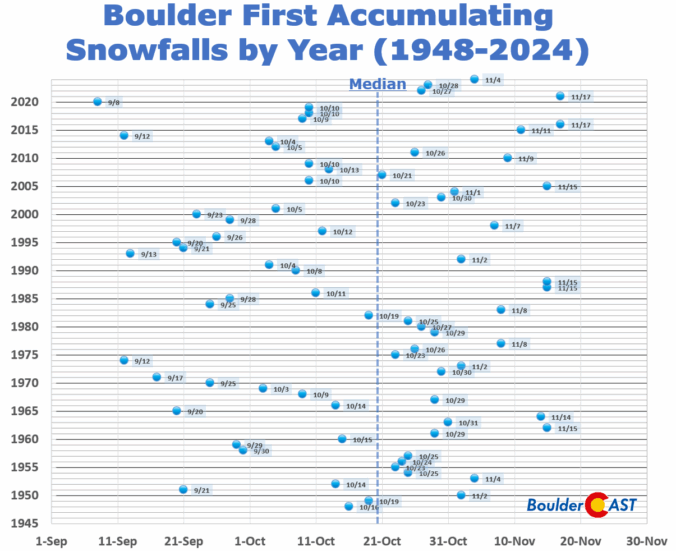
- Where Is The Snow?: Model output and pattern recognition would suggest little to no precipitation through mid November in our area; Boulder may challenge its latest first snowfall record (Nov 17).

Go Premium, get all the perks.
Daily Forecast Updates
Get our daily forecast discussion every morning delivered to your inbox.
All Our Model Data
Access to all our Colorado-centric high-resolution weather model graphics. Seriously — every one!
Ski & Hiking Forecasts
6-day forecasts for all the Colorado ski resorts, plus more than 120 hiking trails, including every 14er.
Smoke Forecasts
Wildfire smoke concentration predictions up to 72 hours into the future.
Exclusive Content
Weekend outlooks every Thursday, bonus storm updates, historical data and much more!
No Advertisements
Enjoy ad-free viewing on the entire site.
Staying cool & crisp through Halloween night
As we detailed in our weekly outlook, we’re locked into a crisp, dry autumn pattern for now, but change is brewing as a strong ridge of high pressure will start moving in from the west this weekend. If we peek at the 500mb height anomaly forecast animation below (running through Monday), we can spot a deep, persistent trough parked over the eastern U.S. That setup will keep Colorado under northwest flow through Saturday—think cool air, clear skies, and that classic fall feel.

Earlier Thursday morning, a weak cold front slid south across the lower elevations. It’s subtle—barely detectable—but seems to be stalled right along I-70, effectively bisecting the Denver Metro. Despite the lack of clouds or precipitation, this front will shave 5–10°F off our highs compared to yesterday. Expect sunny skies and temps in the low to mid 50s.

A pulse of moisture aloft will drift in from the northwest Friday, bringing more cloud cover and keeping daytime highs in the mid to upper 40s. Skies may clear a bit by sunset, but overall it’ll be a gray day. Halloween evening looks dry and calm, but chilly—temps dipping into the 40s and upper 30s. All things considered, not bad for late October in Colorado where snow and bitter cold can be in the cards!

The weekend warm-up
Our warming trend under high pressure will commence on Saturday with temperatures in the lower 60s, followed by mid to upper 70s on Sunday — won’t that feel amazing? Sunday would be perfect for some leaf cleanup or really any outdoor activities. Try to take advantage of what will be a near-record warm early November day if you can!

A weak cold front is expected to slide through Sunday night. Models have been backing off its strength, but we’ll likely see a modest cooldown Monday, with highs dropping into the 60s.

Are we heading towards a record late first snow?
As the western ridge builds and holds across the southern Rockies, we’re likely to stay in a fairly warm pattern most of next week as well, with highs landing in the 60s to lower 70s deep into November.
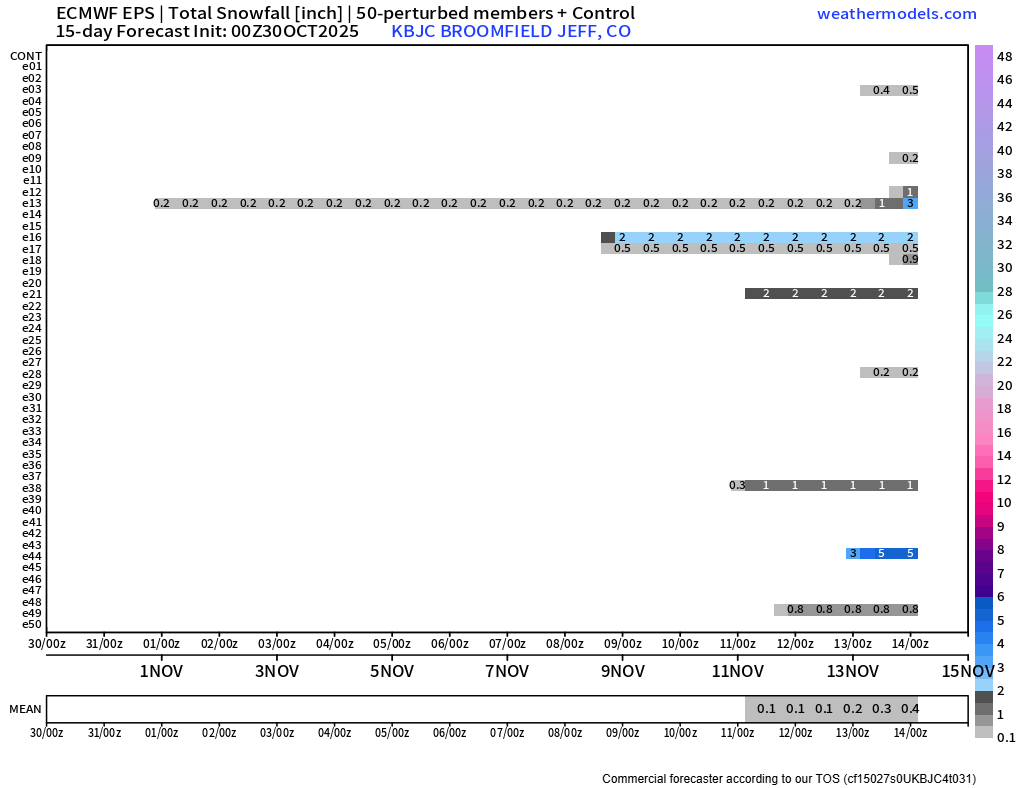
GFS ensembles show zero precipitation for Boulder over the next 7 days. That’s rare for this time of year.

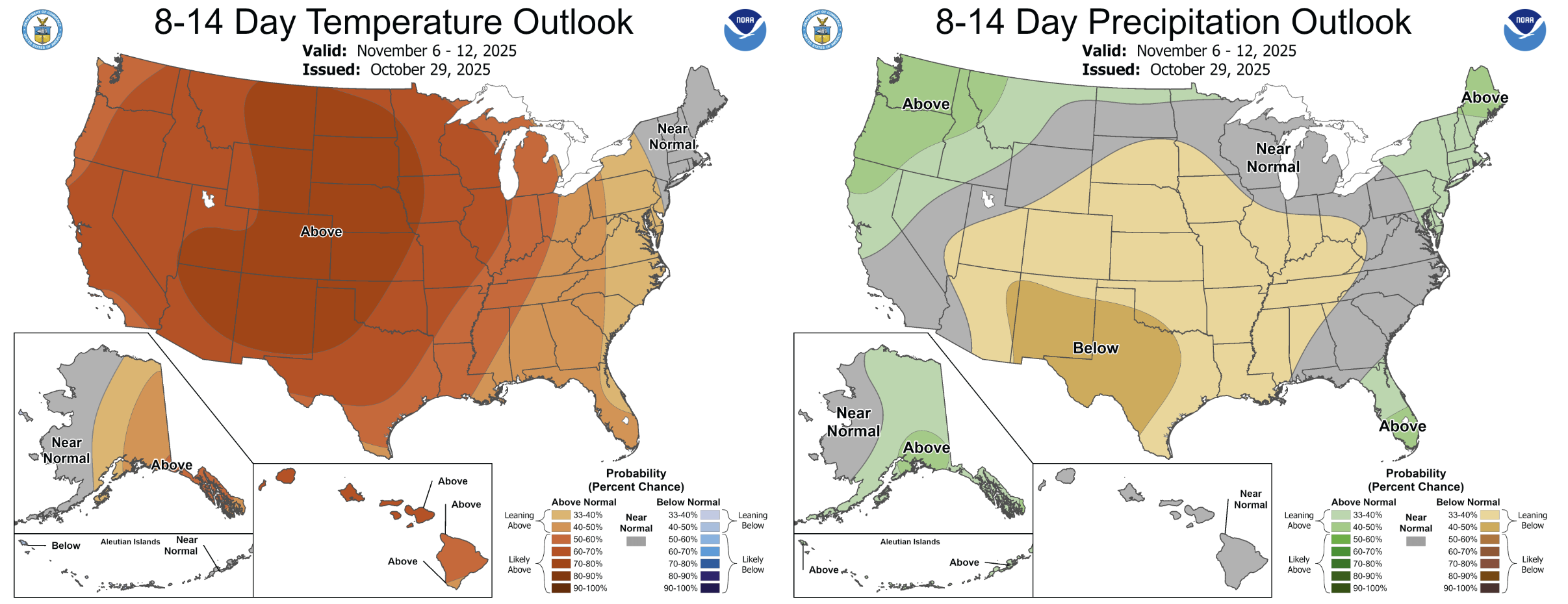
Even looking 8–14 days out, when ensemble accuracy admittedly drops, we’re still not seeing any promising signals for rain or snow. Unless an outlier solution sneaks in and verifies around mid-month, we’re likely staying dry.

That’s exactly how the NOAA Climate Prediction Center is foretelling the second week of November for us right now as well…
Furthermore, only 20% of European ensemble members show any snow through mid-November. That leaves us with an 80% chance of staying snow-free.
If this trend holds, Boulder could very well be chasing its latest first snowfall on record—currently etched into the books as November 17th according to reliable data dating back to 1948.

That’s all we’ve got for you today in this long-range update. Enjoy the continued gorgeous fall weather set to linger for the next 7 to 14 days!
From all of us at BoulderCAST, have a safe and happy Halloween!
![]()
Spread the word—share Colorado weather:
Go Premium, get all the perks.
Daily Forecast Updates
Get our daily forecast discussion every morning delivered to your inbox.
All Our Model Data
Access to all our Colorado-centric high-resolution weather model graphics. Seriously — every one!
Ski & Hiking Forecasts
6-day forecasts for all the Colorado ski resorts, plus more than 120 hiking trails, including every 14er.
Smoke Forecasts
Wildfire smoke concentration predictions up to 72 hours into the future.
Exclusive Content
Weekend outlooks every Thursday, bonus storm updates, historical data and much more!
No Advertisements
Enjoy ad-free viewing on the entire site.


You must be logged in to post a comment.