Front Range weather during the month of May was certainly busy! We got our first taste of summertime thunderstorms, including accumulating hail in spots. There were numerous upslope storms; a few even turned cold enough for snow in Boulder and Denver. La Niña dissipated and the drought showed continued signs of improvement. Here’s a quick and colorful rundown of our weather during May 2021, the notable atmospheric highlights and how it all relates to climatology.
Top Weather Highlights of May 2021:
FIRST THUNDER OF THE YEAR: The first widespread round of thunder in 2021 occurred on May 2nd. Hail and tons of lightning were reported in the Boulder area and later locations to the east as a quick-moving and impressive looking thunderstorm moved off the Foothills and across the northern Front Range.
A storm is brewing! ☔️ #cowx @DenverChannel pic.twitter.com/iLtGhg3VRk
— Pattrik Perez (@PattrikPerez) May 2, 2021
SNOW AGAIN IN MAY? The month began with an onslaught of upslope storm systems which were borderline cold enough for snow across the Denver Metro area. Shortly after the thunderstorm mentioned earlier, temperatures cooled and some snow did mix with the rain in Boulder on May 3rd (just a trace though).
Boulder reported a trace of snow on Monday, the first snowflakes to fall in the city in May since 5/22/2019. Areas above 6500 feet elevation saw between 2 and 8 inches of snow.
Our seasonal snowfall total remains unchanged at 103 inches. #COwx #boulderwx #MaySnow #Spring pic.twitter.com/KCS3NtHuFC
— BoulderCAST Weather (@BoulderCAST) May 4, 2021
A week later on May 10th, it was surprisingly even colder and widespread accumulating snow struck the Front Range. Fortunately it wasn’t much (less than 2″ across the lower elevations), so power outages and tree damage were minimal. Though to be fair, most of the weak limbs were likely already downed by the 2-foot snowstorm in mid-March!
Here's a look at the snowfall totals for this past storm. The highest totals of 12-15" were in the Foothills of Boulder County above 8500 feet.
Boulder recorded just 0.2" of snow from this event, but 1.24" of liquid! Denver a trace of snow and 0.46" of liquid. #COwx #MaySnow pic.twitter.com/krpi9XPLo5
— BoulderCAST Weather (@BoulderCAST) May 12, 2021
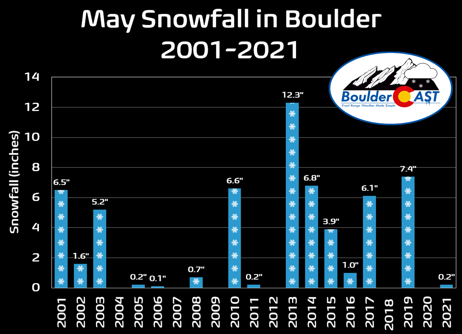
With Boulder officially reporting 0.2″ of snow during the month, the city has now experienced accumulating snow during the month of May 15 out of the last 21 years.
THE CASE OF THE DISAPPEARING DROUGHT: A favorable atmospheric setup across North America, including a big omega block around the middle of May, led to several slow-moving storm systems impacting eastern Colorado during the month, each offering a prolonged period of moist upslope for the Front Range. There were three separate events that produced more than 1.3″ of moisture in Boulder (e.g. #1, #2, #3: Memorial Day Weekend), and another that came in just under 1″. These four major storms made up about 90% of the month’s precipitation.
A DELUGE of moisture dumped across the Front Range the last few days. Estimates and observations show most locations saw between 1 and 2" of rain or melted snow equivalent.
Officially, Boulder saw around 1.5" while Denver (DIA) reported 0.76". #COwx #Boulder #Denver #Rain pic.twitter.com/WgffXSwIlX
— BoulderCAST Weather (@BoulderCAST) May 4, 2021
The full-month’s dump of moisture was spread across all of eastern Colorado, and even some areas in south-central Colorado in the San Luis Valley. The Western Slope picked up little to no precipitation in May (or all of spring really). Places like Moab, Grand Junction, and Salt Lake City all reported well below average precipitation in May.
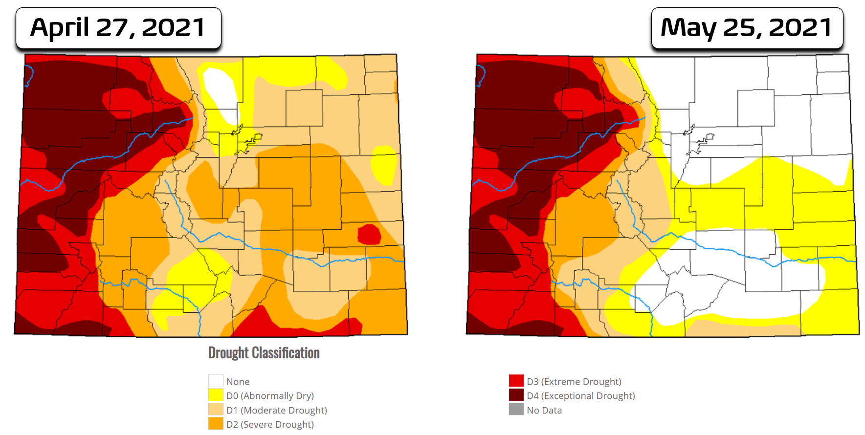
Mother Nature put another dagger into the drought across the region in May. After a wet April, drought was already improving in Boulder at the beginning of the month. This good fortune spread to encompass all of eastern Colorado by the end of May which benefited from the very same wet spring storms.
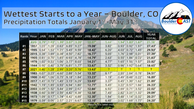
Boulder concluded the month of May with a whopping 5.76″ of precipitation which is 180% of average. This brings the cumulative precipitation total for 2021 to 13.63″, good enough for 7th place all-time since 1894 for the first five months of any calendar year.
The National Weather Service shared a similar graphic for Denver which received 10.49″ of precipitation through the end of May (more than 3″ less than Boulder). This ranked 9th all time for the city to start a calendar year.
After eight straight months with some combination of warm and dry weather in our area, this spring has been a breath of fresh air with cool and wet weather dominating across the Front Range since February. The graphic below says more than we ever could about why the story of the drought has changed so quickly in 2021 for our area!
HAIL YEAH! During one of the heavy and cold thunderstorms on May 17th, a slow-moving cell dumped up to 2″ of hail (yes hail!) in Gunbarrel. It should be on everyone’s bucket list to experience this phenomenon in their lifetime. It’s what we in the business call “plowable hail”! It’s not common, but plowable hail can occur in portions of northeast Colorado particularly in the late spring and early summer months.
Looks like March in Gunbarrel except for the super green grass #9wx #COwx pic.twitter.com/XzzMr2ybw7
— Cory Reppenhagen (@CReppWx) May 17, 2021
R.I.P. LA NIÑA: In case you missed it, La Niña ended officially died during the month of May as sea-surface temperatures warmed in the eastern tropical Pacific Ocean. Though there is still technically a cold anomaly present, the resulting thunderstorm development and wind patterns have shifted away from what is typical during La Niña, so much so that NOAA pronounced the global climatic pattern dead around the middle of the month. 
A WARM, DRY & FIERY SUMMER AHEAD? Despite the wet spring season, a multitude of factors are contributing to the expectation for a warm and dry summer ahead in Colorado. Several signs are pointing to a reduced monsoon season this summer, which by the way follows a nearly non-existent monsoon last year. With the western third of the state locked into devastating drought, the dry times ahead will add fuel to the fire (pardon the pun) across much of the West this summer.
BoulderCAST Premium Flash Sale: Save 25% with promo code JUNE through June 7, 2021.
Help support our team of Front Range weather bloggers by joining BoulderCAST Premium. We talk Boulder and Denver weather every single day. Sign up now to get access to our daily forecast discussions each morning, complete six-day skiing and hiking forecasts powered by machine learning, first-class access to all our Colorado-centric high-resolution weather graphics, bonus storm updates and much more! Or not, we just appreciate your readership!
May 2021 Recap Graphics:
Spread the word, share Colorado weather:
BoulderCAST Premium Flash Sale: Save 25% with promo code JUNE through June 7, 2021.
We discuss Boulder and Denver weather every single day on BoulderCAST Premium. Sign up today to get access to our daily forecast discussions every morning, complete six-day skiing and hiking forecasts powered by machine learning, access to all our Front Range specific weather models, additional storm updates and much more!
Featured image of the snow Front Range by Jason Mowry.


You must be logged in to post a comment.