As May comes to a close, the sizzling heat is about to begin across the Front Range with the official beginning of meteorological summer on Wednesday. We take a look at trends in climatology and offer our predictions for the month of June in Boulder.
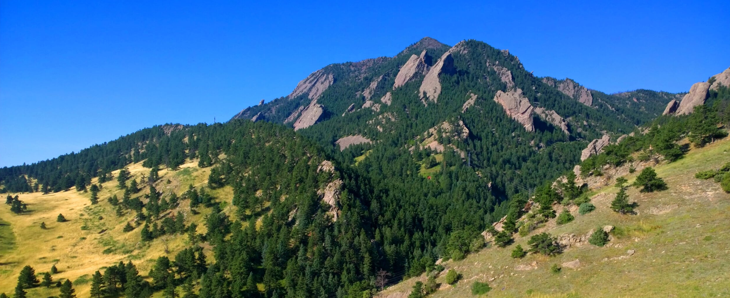
With the spring rainy season coming to a close, a vibrant shade of green covers the land. Contrasting that, the peaks just to the west are often still blanketed in deep snow. June sure is a beautiful time across the Front Range. Let’s take a look of some of June’s weather specifics and finish up with the outlook for next month.
This content is available exclusively to BoulderCAST Premium members until June 1, 2016.
Precipitation
June is Boulder’s fifth wettest month of the year, recording on average just below two inches of precipitation. Typically the month begins on the dry side, with the last week or two going out wet as the summer monsoon starts to kick in.
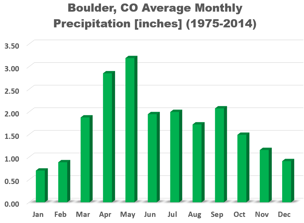
Boulder’s wettest June on record had 7.40″ of precipitation in 1949, while the driest was 1924 where no rain fell at all.
Snow
Hopefully this is the last month we even have to mention snow until September! Though the city has received measurable snowfall as late as June 12th (1.0″ in 1947), snow on the Plains in June is extremely rare, having occurred only five times in the 120-year historical record for Boulder. Chances of snow are greater in the Foothills, but only slightly, and mostly only for the areas above 8,000 feet.
Temperature
June is our third warmest month of the year, with an average daytime high of 82 degrees, increasing from 75 on June 1st, to 85 by June 30th. Quite the warm-up! Our hottest June temperature in the books occurred on June 4, 1954 at 104 degrees.
The warmest June on record was just four years ago in 2012. In the midst of a worrying drought, eastern Colorado was setting all kinds of heat records. After a very warm/dry winter and spring in 2012, the land was parched. Due to a lack of evaporative cooling, drought in our region contributed to intense heat later down the line. This is a prime example of how the atmosphere can feedback on itself. Take a look at how June of 2012 played out below.
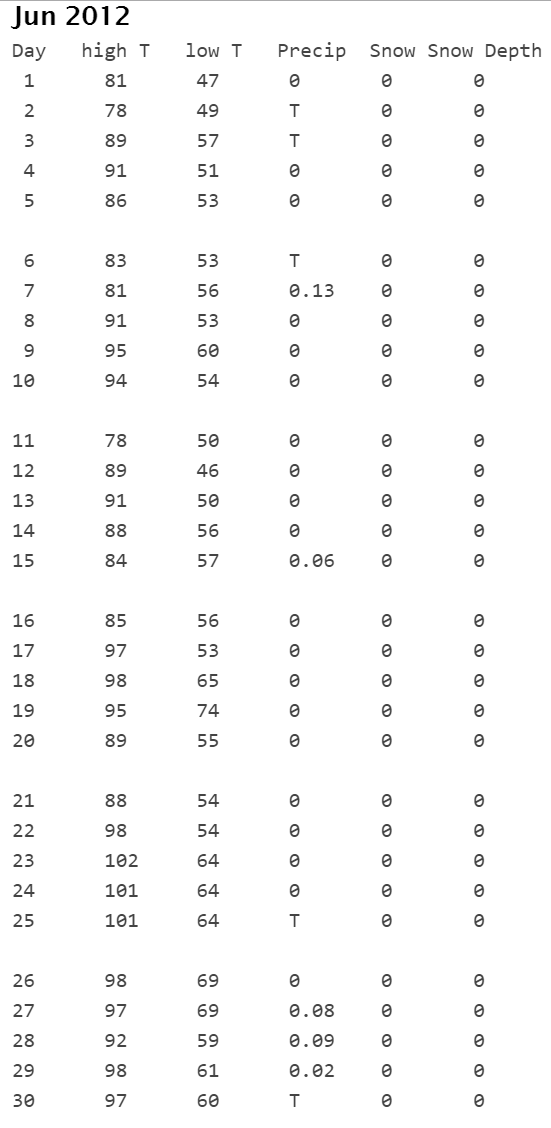
June 2012 had three days above 100 degrees in Boulder, and seven days with temperatures in the upper 90’s! Denver tied its all-time record high temperature on June 25, 2016, soaring to 105 degrees. Not surprisingly, 2012 was a horrific season for wildfires across the state, including the Flagstaff Fire just west of Boulder, which was ignited by lightning on June 26, 2012.
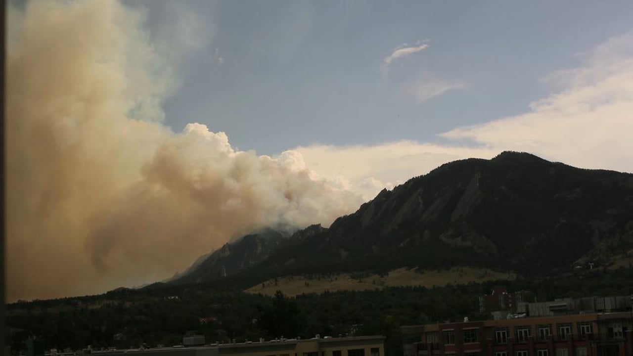
Flagstaff Fire – June 2012 – Boulder, CO
Severe weather
June is Colorado’s most active month for severe weather, with the peak occurring near the middle of the month. We’re talking large hail, damaging winds, and even tornadoes.
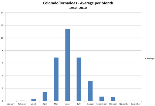
Average tornadoes observed by month in the entire state of Colorado. Data provided by NCDC.
In fact, last June a severe storm produced an EF3 tornado and tennis ball sized hail in northern Boulder County. Luckily no one was injured as the twister struck in the farmland north of Longmont. Tornadoes this close to the Front Range can be especially dangerous considering the high population density of the Denver Metro area.
If there is one time of year we all need to be extra aware of the weather around us, it is during the month of June! We’ll be sure to keep you updated if anything materializes for severe weather across our region.
Outlook for June 2016
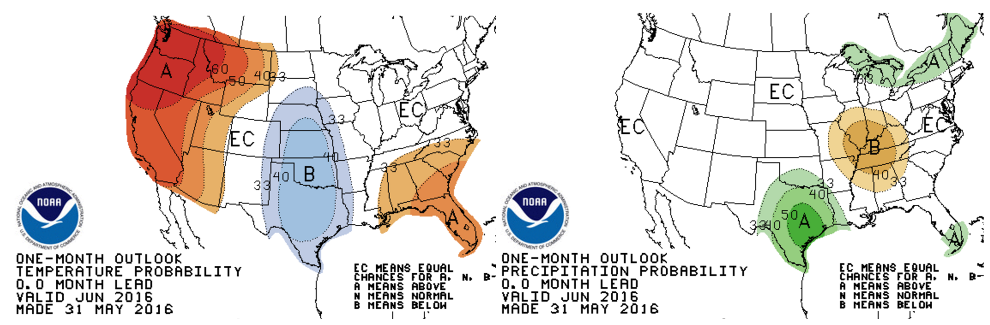
The long-range guidance of the CFS model suggests that the Front Range will be slightly drier than normal for the month of June, with no signal present for our temperatures.

CFSv2 model outlook for the month of June. Temperature anomaly is to the left, while precipitation anomaly is to the right.
Looking at the GFS and European ensembles for the first two weeks of June, both show a more-or-less persistent ridge encapsulating much of the western United States, including Colorado. This would lend to relatively dry and very warm conditions. The loop below is for 500 mb height forecast from the European ensemble from June 1st to 10th, 2016. Lots of red (ridging) across the West. With this signal in multiple models, it’s likely the first half of June will be quite dry and warm.
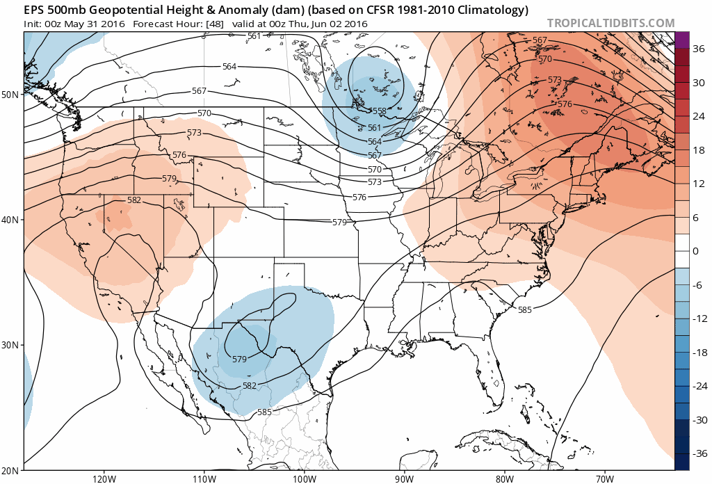
ECMWF ensemble forecast of 500 mb geopotential height for the first 10 days of June
One way we can extrapolate past weather patterns towards predicting future weather is through analogs. Using this technique, we compare recent weather data (from the last few months) to the historical record. Based on our analysis, Boulder’s best analog years for 2016 (heading into June) are 2010, 2003, 1987, 1995, and 1971. Interestingly, just like this year, 2010, 2003, and 1995 were all years in which a weakening El Niño was present.
Based on the top ten analogs, there is indication that this June could be wetter than normal (70% chance). Considering that 1.40″ of rain fell in the first 8 hours of June already, this projection for precipitation seems likely. However, Boulder’s analogs give no insight into temperature (top 10 analogs show equal chances of above and below normal temperatures).
NOAA’s Climate Prediction Center is expecting equal chances of both above and below normal precipitation and temperature for the Front Range (i.e. they aren’t leaning towards anything at all).
Blending everything we are seeing, we are predicting above normal precipitation and near normal temperatures for the month of June in Boulder. There is too much conflicting evidence to say otherwise on temperature. We do expect June to be back-loaded with it’s precipitation, however.
Get out there and enjoy all that the first month of meteorological summer has to offer! The warmer temperatures will be welcomed…the severe weather maybe not so much (unless you are storm chasers like us!).
How did we do last month?
Our May outlook called for below normal temperatures and near normal precipitation (we went against the CPC for precip; they were predicting wetter than normal).
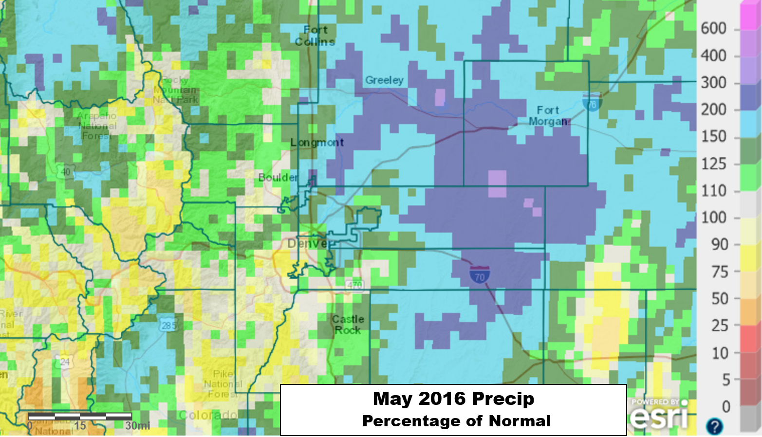
Though May was very wet east of Denver, in Boulder precipitation was much closer to normal. Boulder’s official total for the month was 2.01″ (a little less than one inch below normal). However, at BoulderCAST Station in North Boulder, we measured 2.69″…more or less normal for the month. This demonstrates the largely hit or miss nature of the rain showers during the month and fits in with the radar estimates from the precipitation map above. Click here for a daily weather summer for May 2016.
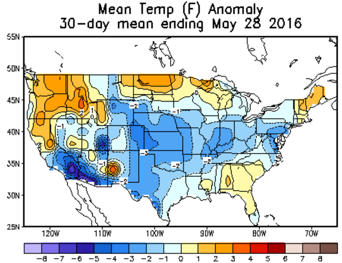
For temperature, Boulder and most of Colorado ended up well below normal during the month of May. Boulder’s mean temperature was 54 degrees, which falls a hefty 4 degrees shy of average. We only had one 80-degree day, and concluded the month with 10 consecutive days having below normal temperatures.
As you can see, both our temperature and precipitation predictions worked out fairly well in May. Let’s hope June cooperates just as much.


You must be logged in to post a comment.