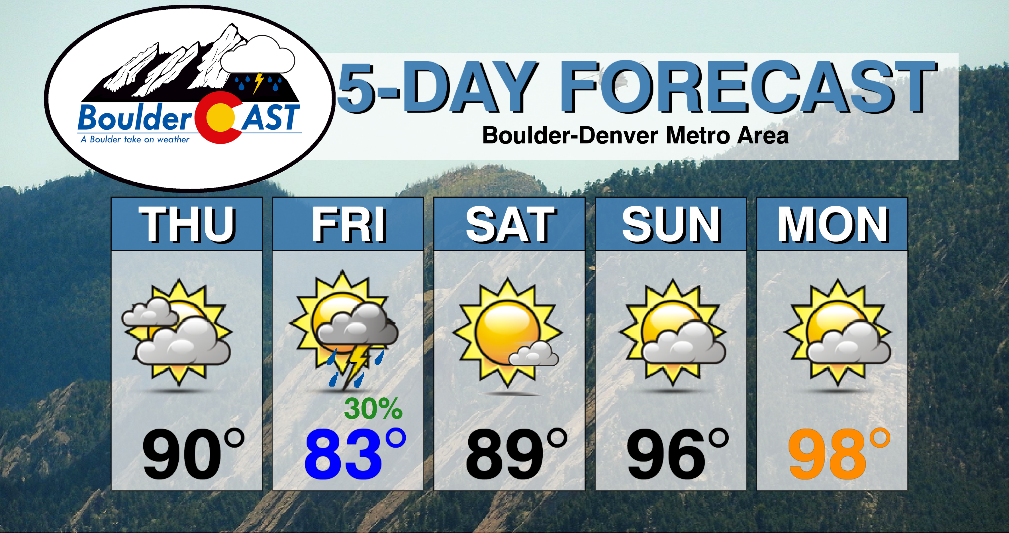
We discuss the outlook for what is shaping up to be a pleasant holiday weekend, albeit under the duress of near-record heat.
DISCLAIMER: This weekend outlook forecast was created Thursday morning and covers the next five days. Accuracy will decrease as time progresses as this post is NOT updated. To receive daily updated forecasts from our team, subscribe to BoulderCAST Premium.
I
n our weekly outlook on Monday, we likened this week’s projected temperatures to a roller-coaster ride. So far, this prediction has panned out with Monday and Tuesday in the 70’s and now Wednesday and Thursday in the 90’s. In fact, Wednesday nearly set a record low AND record high in Boulder on the very same day, climbing all the way to 94 degrees in the afternoon from the chilly morning low of 47 degrees. This was the second largest single-day swing in temperatures in 2019, just one degree behind April 10th when temperatures fell of a cliff during “Bomb Cyclone 2.0”.
The tragic shifts in temperatures this week occurred because of the specific weather pattern in place. A persistent high pressure has been holding across Arizona for some time now, which has taken a big bite of the monsoon this summer. At the same time, a deep trough has developed across the Great Lakes this week, a sign that autumn is nearing closer. This has put Colorado in the transitional zone of northwest flow allowing for a series of cold fronts to impact our area. There was one on Monday, another on Tuesday, and as you can see below, a final cool front is expected to move into northeast Colorado early this afternoon.
Thus, today will be a day of transition as the hot and dry airmass is replaced by a slightly cooler one which has more moisture. Currently high-resolution models have the front moving into the Denver Metro area around the lunch-hour. Before this, most areas should crack 90 degrees, especially in the southern and western suburbs where the front will arrive last. Post front, temperatures will relax back into the 80’s with on-and-off breezy northeasterly winds.

NAM 800 mb temperature and wind forecast for Thursday at 6PM. Cooler air behind the front will be filtering into the Front Range
Despite the influx of low-level moisture behind the front Thursday afternoon, it doesn’t appear it will be enough to counteract the cooling at the surface from the front and the thick deck of alto-stratus clouds (below). Thus the airmass will remain stable with no storms expected.
This stability will go out the window on Friday, however. Clearing skies will allow for more sunshine to fuel the development of late afternoon and evening storms across the Front Range to end the week. Storms will be scattered, so not everyone will see the much-needed rainfall, but do know this will be our best (and only?) chance of rain for the week and weekend. High temperatures on Friday will be slightly cooler in the 80’s.
For the elongated holiday weekend, the high pressure mentioned earlier will migrate northeastward and park itself directly over Colorado. You can see this transition happen in the GFS forecast animation of 500 mb height anomaly below.
Despite Monday being five days away, we see very good agreement among models and their ensembles for this pattern taking hold over the south-central United States. We’re fairly confident in the weather over the next five days as a result.
Overall, this pattern will translate into a rather dry and sunny holiday weekend across almost all of Colorado. Temperatures will be above seasonal values, likely even approaching record highs on both Sunday and Monday in and around Denver with highs in the middle to dare we say upper 90’s. After Friday, our next shot at rain likely won’t come until Tuesday when the next, albeit weak, storm system moves across the cap of the ridge into the northern Great Plains.
From all of us at BoulderCAST, we wish you a joyous holiday weekend. If you’re heading up to the Mountains, don’t forget to check SummitCAST for the latest on what conditions will be like. We’ll be back Monday with our usual weekly weather update.
P.S. If Boulder doesn’t squeak out a little rain on Friday, this August will go down as the second driest in the city’s 128-year climate record! It might be time to do a little rain dance…
P.S.S. All eyes are upon Hurricane Dorian which is tracking towards the southeastern United States. In the most probable scenario, Dorian makes a landfall in eastern Florida late Sunday or early Monday as a devastating Category 3 or 4 hurricane…
Forecast Specifics:
Thursday: Mostly cloudy and hot with highs reaching the lower 90’s by mid-day. Then breezy northeast winds with slightly falling temperatures through the afternoon back in to the 80’s.
Friday: Morning sunshine, then partly cloudy with scattered afternoon and evening thunderstorms. Highs in the lower to middle 80’s.
Saturday: Warmer with increasing clouds. The Metro area should remain dry, but a few isolated storms may pop across the Palmer Divide and southward. Highs in the middle to upper 80’s.
Sunday: Near-record heat with morning sun giving way to partly cloudy skies in the afternoon. Highs in the middle 90’s.
Monday: Near-record heat with morning sun giving way to partly cloudy skies in the afternoon. Highs in the middle 90’s.
.
Share the BoulderCAST forecast!
.


You must be logged in to post a comment.