It’s hard to believe that August is now upon us! Where is the summer going? June and the first half of July were cooler than normal with summer barely making an appearance. The heat has really ramped up over the last three weeks though, including a ten-day stretch of 90-degree weather in Boulder. Should we expect more of the same in August? Read on as we examine Boulder’s climatology and consider the current state of the atmosphere to give our outlook for the next month.
The TL;DR of August 2019
August Climatology
Precipitation
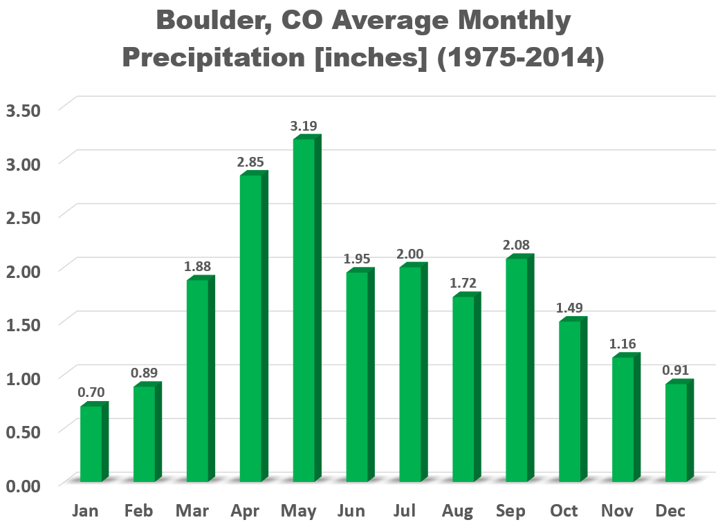
The monsoon is usually in full-force at the beginning of August, but slowly tappers off as the month progresses. August comes in as Boulder’s 7th wettest month on average, with a typical year seeing 1.72″ of rainfall.
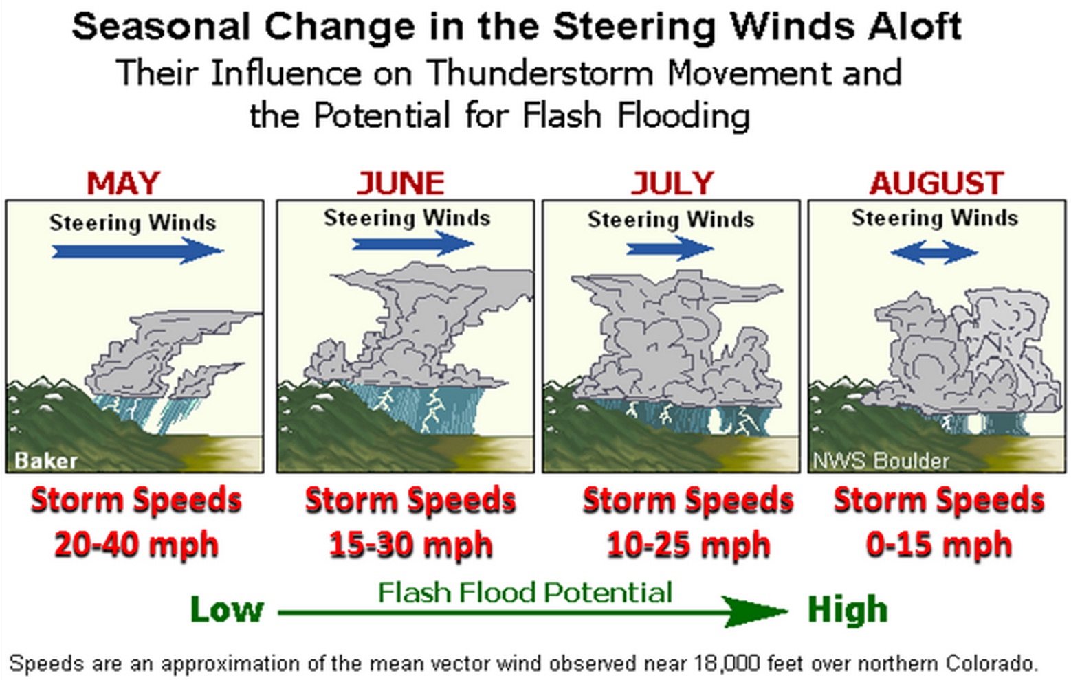
Colorado also tends to see a weakening of the upper-level winds in August as high pressure builds aloft. Combined with the relatively abundant monsoon moisture, these reduced steering winds allow developing thunderstorms to drift very slowly or remain stationary for extended periods of time, bringing the potential for tremendous amounts of rain to fall. This is especially true when you add the remnants of an old frontal boundary to the mix. Just look at today’s forecast…
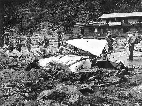
As a result, not surprisingly, some of the worst floods in state history have occurred in (early) August. The Big Thompson Flood of 1976, the deadliest flood in Colorado’s history, occurred on July 31 (just a few hours before August began), and more recently, on August 10, 2013, heavy rain triggered flash floods and mudslides west of Colorado Springs. The last week of July and the first week of August are historically the peak in flash flooding for our region. However, the risk remains elevated into September, when moisture levels finally begin to drop and the upper-level winds pick back up once again (e.g. remember that flood we had in September 2013?).
Wettest August: 7.41″ (1951)
Driest August: 0.03″ (1985)
Temperature
August is Boulder’s second warmest month, having a monthly mean temperature of 71 degrees (July is warmest at 73 degrees). Climatologically, the first of the month begins the decline in average daily high temperature, trending from 85 to 82 degrees by the close of August. The all-time record hottest temperature for the month is 102 degrees, occurring on August 24, 1936. The coldest temperature occurred on the 25th in 1910, when the mercury plummeted to 37 degrees.
Things to watch during the month of August
FLASH FLOODING!
Turn around, don’t drown!
EASTERN PACIFIC TROPICAL CYCLONES
Hurricane season across the eastern Pacific Ocean ramps-up significantly through the month of August. Much more-so than the Atlantic, Pacific hurricanes can and do influence the weather in Colorado through deep tropical moisture injection when they curve northeastward into the Baja Peninsula. The current large-scale pattern, a high pressure center across the Four Corners, does not favor tracks for tropical cyclones towards Colorado. Long-range models show this unfavorable pattern persisting for the first half of the month as well. Nonetheless, it is still something to watch. Two tropical cyclones are active now…Hurricane Erick and Tropical Storm Flossie, both of which are way out to sea and moving away from North America.
A DYING EL NIÑO
It’s likely that sea surface temperatures in the equatorial Pacific Ocean will return to near-average soon, qualifying for “ENSO-neutral” conditions. The latest guidance from both dynamical and statistical climate models suggests that there is about a 60% chance of an El Niño dissipating during the month of August. ENSO-neutral is the favored pattern to persist through the upcoming fall and winter seasons.
LINGERING MONSOON WITH RELAXING HEAT?
We’ve already had 18 days with temperatures hitting at least 90 degrees in Boulder, many of which have come in just the last three weeks. The Climate Prediction Center is predicting elevated odds of not only cooler than normal temperatures, but also above normal rainfall.
Nearly an identical pattern is indicated in the latest runs of the Climate Forecast System model, too…
We think August 2019 will turn out near or slightly below normal in regards to temperatures. Based on the late arrival of the monsoon this year, we’re hopeful that it will stick around a little longer than usual, keeping those afternoon storms popping well into September. Considering the deluge of rain on the table for today (the first of the month), chances are looking good for above normal precipitation as well.
Spread the word, share this content:
.


You must be logged in to post a comment.