
Change is already unfolding across the Front Range with 90’s now a thing of the past for the time being. A series of cold fronts will bring much cooler temperatures to the area in the coming days, with even some Mountain snow sprinkled into the extended outlook. Let’s take a look at the welcomed cool-down we’ve all been anticipating for more than two months.
At a Glance:
- The ridge of high pressure withers away to our south with a cooler pattern developing today through the middle of next week
- Two Canadian storm systems will impact the Front Range Monday and Tuesday
- Highs fall into the 60’s and 70’s, with no 90’s to be found
- Several chances for widespread rainfall, with even some light accumulating snow in the Mountains
Help support our team of Front Range weather bloggers by joining BoulderCAST Premium. We talk Boulder and Denver weather every single day. Sign up now to get access to our daily forecast discussions each morning, complete six-day skiing and hiking forecasts powered by machine learning, first-class access to all our Colorado-centric high-resolution weather graphics, bonus storm updates and much more! Or not, we just appreciate your readership!
Save 30% and Join Premium Today
Goodbye 90’s and good riddance!
It has been a brutally hot summer across the Front Range, particularly during the month of August. Boulder notched its 45th 90-degree day of the year on Thursday reaching a high of 94°F. This puts 2020 into 15th place for the most 90-degree days in a single calendar year (with data stretching back to the late 1800’s). Denver has had a more impressive 67 days above 90 degrees, which ranks at a more studly 2nd place in Denver’s historical record. For reference, the worst of the heat should be behind us now (obviously). After August 28th, Boulder only averages three additional 90-degree days as summer winds down and transitions into autumn.
We just eclipsed 90°F in Boulder again for the 45th time in 2020. This ranks #15 all-time for most 90° days in a calendar year. It may be hard to believe, but historically we average only 3 additional days above 90°F after August 27th: https://t.co/AN31TRHGh3
#COWx #Boulderwx pic.twitter.com/F1bkOqFjzx
— BoulderCAST Weather (@BoulderCAST) August 27, 2020
We’re not going to talk about the heat anymore today, or anytime soon for that matter. If you haven’t noticed, a cold front moved through last night right on schedule with Friday’s afternoon high temperatures dropping around 10 to 15°F compared to Thursday.

The cool and moist airmass that has pushed into northeast Colorado will help fuel more numerous showers and thunderstorms today and for the next several days. Things should get cranking shortly here by mid-afternoon with the chance of storms continuing into Friday evening. Expect highs today in the lower 80’s…the coldest day for us since late July.

HRRR simulated model radar animation for Friday afternoon and evening
Moisture has really increased across the area in the last 24 hours with precipitable water values later today peaking above 1″ across the lower elevations, with some areas even above 1.25″ (shown below). This deep moisture will lead to the possibility of very heavy rainfall rates this evening. Keep an eye to the sky and watch for localized urban flooding. We need the rain, flooding or not!

GFS precipitable water forecast for Friday evening. Deep moisture is present over the Front Range, leading to potential for heavy rain
The cooler and rainier pattern will continue through the upcoming weekend as highs remain below 90 degrees with good chance for showers and storms. Saturday could actually be a fairly gloomy day with a shortwave disturbance passing across Colorado in the morning. Expect a mostly cloudy day with light rain in the morning into mid-day and then isolated storms redeveloping in the evening. Highs reach only the upper 70’s to lower 80’s. What a welcomed change from the heat of late!
Sunday will see more typical summertime weather for us. Highs warm back up into the mid to upper 80’s with increasing clouds and widely scattered afternoon thunderstorms.
Chilly early next week, some Mountain snow
The slight warm-up on Sunday will be short-lived as two colder storm systems will impact the Front Range. The first comes Sunday night followed quickly by the colder of the two systems Monday night that could more directly target Colorado.
The GFS 500mb height anomaly animation below shows the two systems in question dropping out of western Canada. Notice how the second one will be a more significant player for Colorado.

Not to get anyone too excited, but models are showing enough cold air for a light dusting of snow in the Mountains with that secondary system. This is the first time we’ve seen any snow in the models since mid-June! A great sign of the changing seasons, but even still, we’re only talking about a dusting to 1″ or so.

The current timing on any potential snowfall is Monday night into mid-day Tuesday as snow levels drop down to around 10500 to 12000 feet elevation.

With the warm ground surface (it’s still summer after all), accumulation would likely be limited to the very tops of the highest peaks. SummitCAST is showing a prolonged period of light snow chances for most of the 14ers statewide. Here’s a look at the extended forecast for Longs Peak:

Around 1″ or so is currently in the forecast pipeline for all of northern 14ers:

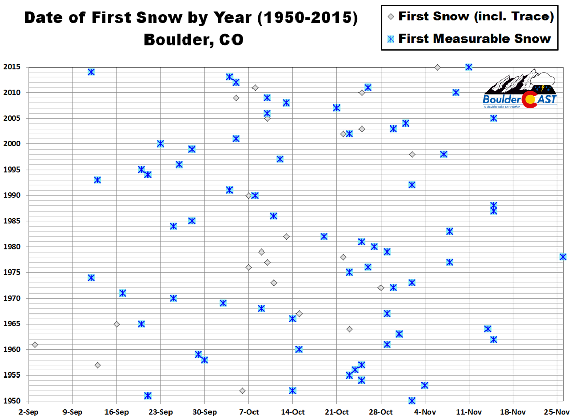
We’ll have to wait and see how things shake out with the Canadian systems next week, but do know at least the potential is there for an early taste of winter weather on Colorado’s highest peaks! And who knows, climatology tells us that the first snow of the season in the city of Boulder could be just two weeks away!
Across the lower elevations of the Boulder-Denver area, rain and much colder temperatures will be the story early next week. At least two “Canadian” cold fronts will drop across the Front Range knocking highs all the way down into the middle 60’s to middle 70’s Monday and Tuesday. It’s been so long since we’ve felt those cool and crisp 60’s! We are definitely ready!

That’s all for now. Check back on Monday for our usual weekly outlook, or just save yourself the trouble and subscribe. Enjoy the cooler weekend and even cooler early week ahead!

Help support our team of Front Range weather bloggers by joining BoulderCAST Premium. We talk Boulder and Denver weather every single day. Sign up now to get access to our daily forecast discussions each morning, complete six-day skiing and hiking forecasts powered by machine learning, first-class access to all our Colorado-centric high-resolution weather graphics, bonus storm updates and much more! Or not, we just appreciate your readership!

.
Subscribe to receive email notifications for BoulderCAST updates:
We respect your privacy. You can unsubscribe at any time.
Spread the word, share this BoulderCAST post:
.


You must be logged in to post a comment.