
After more than two consecutive weeks of hot weather, the pattern is set to shift following the passage of a welcomed cold front Friday evening! While not directly tied to the monsoon, storm chances will ramp up considerably in the near-term. Unfortunately, at the same time weak winds aloft under high pressure will introduce a real risk of flash flooding over the next few days with recent wildfire burn scars at the highest risk (Calwood, Cameron Peak, etc.). We discuss some historical context for July’s weather so far, when the cold front will arrive, how chilly it will be the next few days, and expected rainfall totals by the end of the weekend across the Front Range.
At a glance:
- July has largely been hot and dry for the area, though Boulder is a wet and slightly cooler outlier
- After one more day in the 90’s on Friday, the pattern quickly shifts bringing cooler and wetter weather
- Scattered slow-moving thunderstorms will produce pockets of very heavy rainfall Friday and Saturday
- Flash flooding is possible anywhere in Colorado the next few days, but recent burns scars are at the highest risk
- Late July into early August is the most active time of year for flash flooding in the Front Range
- Remember….. Turn Around, Don’t Drown!
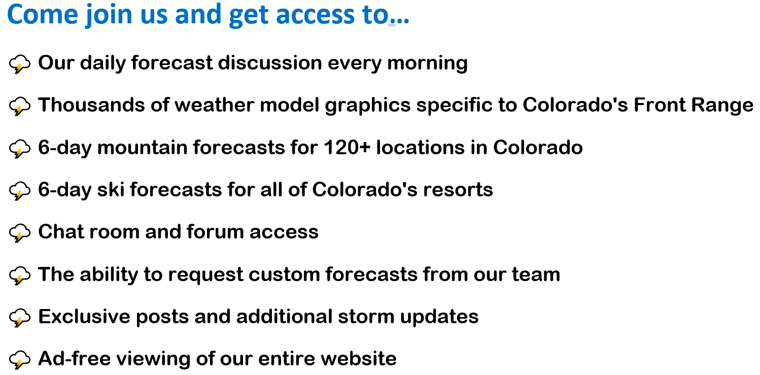
Help support our team of Front Range meteorologists by joining BoulderCAST Premium. Get the most accurate Boulder and Denver weather forecasts delivered to your inbox every single day plus much much more…

*Sale price valid for new subscribers only*
T
here’s no doubt about it. July has been hot! We’re currently riding a 14-day streak of above normal temperatures in the Denver Metro area. The last day that we were cooler than typical was July 15th. Can you remember back that far?
Denver hit the century mark for the fifth time this year earlier this week, which by the way is good enough for 3rd all-time for most triple-digit days in a single year since the late 1800’s.
100-degree days this year: Denver 5, Boulder 0 https://t.co/ekI9ksD3Uz
— BoulderCAST Weather (@BoulderCAST) July 28, 2021
Boulder has yet to reach 100 degrees this year, but not surprisingly is tracking well above normal right now for its count of 90-degree days (see below). We’re up to 25 as of writing.
Outside of the searing heat, a more critical issue this summer has been the lack of monsoon moisture reaching northern Colorado. Since the official start of monsoon season in early July, appreciable rainfall has been hard to come by. This suppressed monsoon pattern is something we warned about in our summer outlook posted more than two months ago. Most of northern and eastern Colorado have been running rainfall deficits so far this month, though portions of the Sangres and San Juans have seen periodic surges of moisture at times, as shown below.
Just about the only city in the Front Range reporting above normal precipitation this month is Boulder, 2.70″ so far, but that is largely due to a pair of highly localized torrential downpours, one on July 1st and another on July 25th. The latter caused significant street flooding in west-central Boulder earlier this week.
>2" of rain fell in less than 90 minutes in parts of Boulder on Sunday. Here's a closer look at the outflow boundary that helped to ignite the strong storm. It travelled ~70 miles from Limon to the base of the Foothills in 4 hours #Boulderwx #COwx
More: https://t.co/KYePKkmfXK pic.twitter.com/z3oDyIDpPa
— BoulderCAST Weather (@BoulderCAST) July 26, 2021
The rest of the Front Range has been mostly dry. Denver in particular has been uncharacteristically parched this month, with Denver International Airport officially recording only 0.23″ of rain through July 29th. If the month ended right now, this would go down as Denver’s 3rd driest July on record! Fortunately, July still has a little life left to live and welcomed rainfall is scheduled to make an appearance just in time!
Surprisingly, the anticipated uptick in rainfall potential today and this weekend will largely NOT be tied directly to the monsoon. Instead, we can thank a strong (by mid-summer standards at least) cold front dropping southward across the Great Plains and ultimately the upslope flow into the Denver Metro area. As you can see in the precipitable water forecast below, monsoon moisture begins in Arizona and southern California but surges awkwardly into the Pacific Northwest. The elevated moisture coming our way over the next few days is instead tied to a cold frontal boundary arriving from the northeast.

GSF precipitable water anomaly forecast animation spanning Friday into next Wednesday
The animation above runs all the way into the middle of next week. For the most part, moisture remains above average across the Front Range during this time, spelling out revolving storm chances for the area…with decent odds for rain much of the next five days before things begin to dry out. It’s worth noting that some of the moisture during this timeframe will indeed be monsoonal (mainly Monday and beyond), but it won’t be taking the typical path to reach us. Instead, an elongated and tilted high pressure center will force the subtropical moisture up into the Pacific Northwest, then eastward across the northern Rockies, and then finally southward into Colorado. This lengthy trek to reach us will strip away some of the available moisture compliments of upstream showers and thunderstorms, but there should be enough left for the Denver area for scattered storms well into next week.
The aforementioned cold front is slated to arrive late in the day Friday, aided partially by outflows from developing thunderstorms moving in from the northwest. Can you spot the cold front diving southward across eastern Colorado and the Great Plains in the surface temperature forecast below?

NAM-NEST surface temperature forecast animation for Friday morning into Saturday night showing the frontal boundary
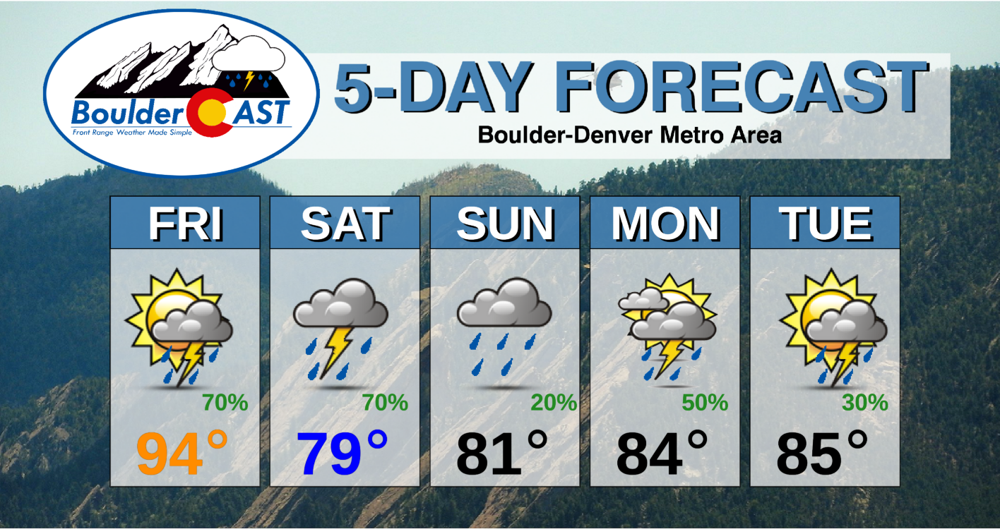
Temperatures today should reach into the 90’s by mid-afternoon on Friday but will quickly fall as the dark clouds and scattered thunderstorms roll off the higher terrain thereafter. Hooray…this it the beginning of a cooler stretch of weather for us! Watch out for scattered thunderstorms to develop by late afternoon, with chances continuing all the way until after midnight Friday night!

Saturday will be much cooler and cloudier with temperatures in the upper 70’s to lower 80’s, a comfortable change from the recent hot stretch. With upslope flow persisting, moisture will actually pile up against the terrain. While it may be too cold, cloudy and dry for storms to develop across the northeast corner of the state on Saturday, areas in and near the Foothills will have ample moisture available and more instability. As a result, scattered to widespread showers and storms will develop during the day Saturday and continue into the evening.
Any storms the next few days will bring bursts of heavy rainfall and storm motions will be slow as well. You know what that means: the flash flood threat will be elevated! Two high-resolution, convection-allowing models (CAMs) are indicating the potential for localized areas to see in excess of 2″ of rain through Saturday night! Will you get lucky?

Flash Flood Watches are now posted for a large portion of Colorado including the entire Denver Metro area for the first time this summer. Note that this is a multi-day watch which runs through Saturday night. This is the real deal, folks!
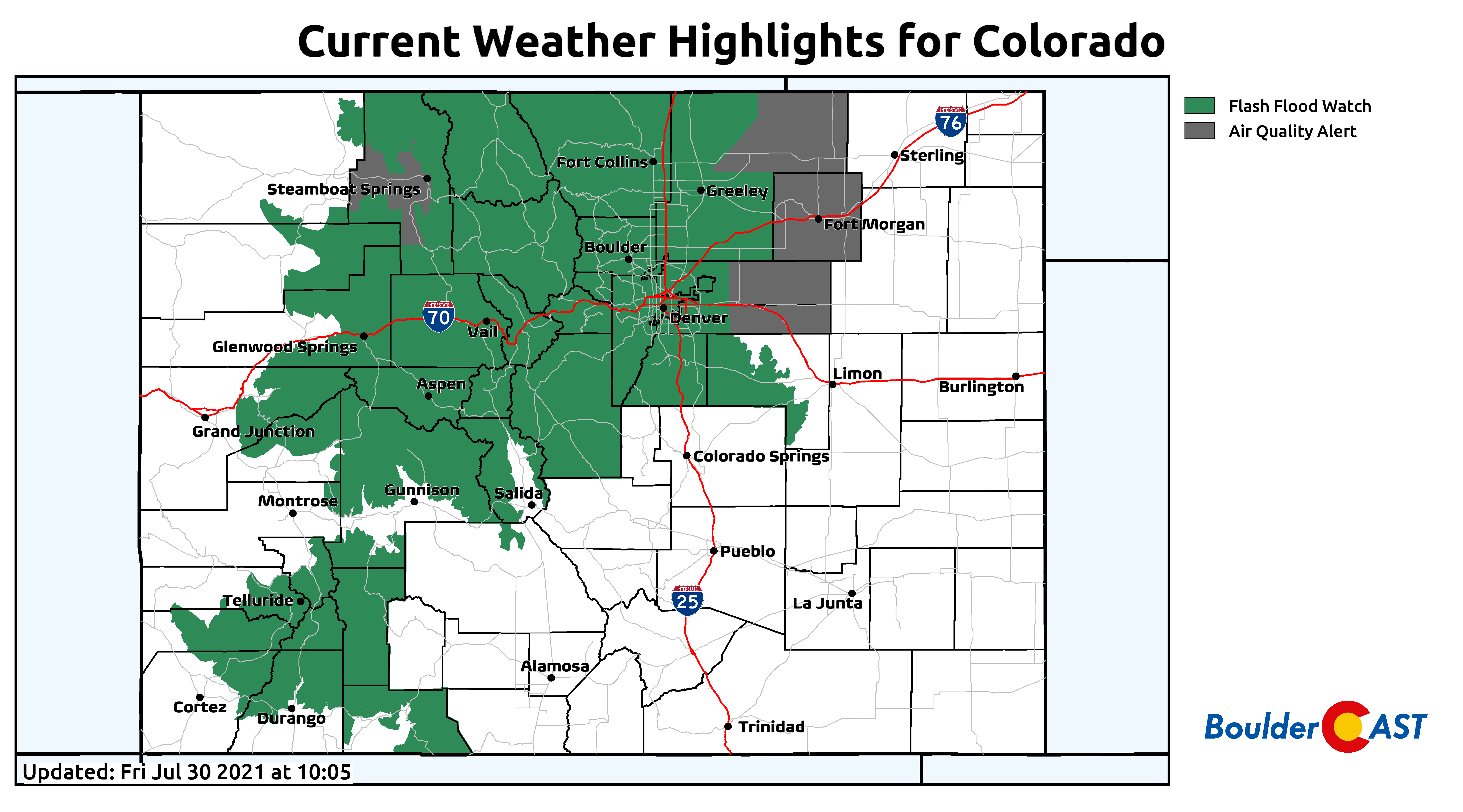
Of course the areas at highest risk this weekend will be recent burn scars from 2020’s record fire season. The National Weather Service has provided this handy graphic showing the timelines of greatest risk for each burn scar. Our team is particularly concerned about the Calwood and Cameron Peak fires Friday and Saturday. If you live downstream from those areas, be very aware this weekend and pay attention to all your devices for flash flood notifications!

The Front Range is no stranger to flash flooding this time of year. Our usual weather pattern facilitates a weakening of the upper-level winds as high pressure builds aloft. Combined with the typically abundant monsoon moisture, these reduced steering winds allow developing thunderstorms to drift very slowly or remain stationary for extended periods of time, bringing the potential for tremendous amounts of rain to fall. This is especially true when you add in cold frontal boundaries arriving from the northeast. That is the exact setup and cause for concern this weekend!
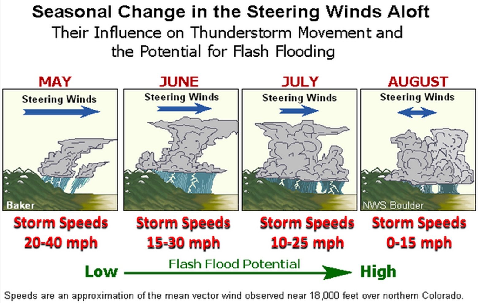
Not surprisingly, some of the worst floods in state history have occurred in late July and early August. The Big Thompson Flood of 1976, the deadliest flood in Colorado’s history, occurred on July 31st, and more recently, on August 10, 2013, heavy rain triggered flash floods and mudslides west of Colorado Springs. The last week of July and the first week of August are historically the peak in flash flooding for our region. However, the risk remains elevated into September, when moisture levels finally begin to drop and the upper-level winds pick up once again (e.g. remember that flood we had in September 2013?).
Sunday we stay cool and dry out a little, but storms look to return in greater numbers for early next week. Temperatures will also trend upwards.
We hope you have an enjoyable yet safe weekend and remember, TURN AROUND…DON’T DROWN!
Stay up to date with Colorado weather and get notified of our latest forecasts and storm updates:
We respect your privacy. You can unsubscribe at any time.
SPECIAL SALE: Use promo code MONSOON to save 25% on an annual subscription to BoulderCAST Premium. This offer ends Monday August 2nd.
Help support our team of Front Range meteorologists by joining BoulderCAST Premium. Get the most accurate Boulder and Denver weather forecasts delivered to your inbox every single day plus much much more…
*Sale price valid for new subscribers only*
.


You must be logged in to post a comment.