Change is happening NOW! After a few days close to 80 degrees in Boulder and Denver, temperatures will tumble today into the 50’s with widespread precipitation developing through the day Tuesday and lingering well into Wednesday. The initial threat will be thunderstorms Tuesday afternoon, but that concern will shift to heavy snow in the Foothills Tuesday evening and night. Let’s take a quick look at the forecast for this spring storm!
We discuss Boulder and Denver weather every single day on BoulderCAST Premium. Sign up today to get access to our daily forecast discussions every morning, complete six-day skiing and hiking forecasts powered by machine learning, access to all our Front Range specific weather models, additional storm updates and much more!

At a Glance:
- A strong Pacific storm will impact the Front Range Tuesday and Wednesday with rain and snow
- Scattered thunderstorms will develop Tuesday afternoon with some turning severe east of Interstate 25
- Widespread rainfall Tuesday night into Wednesday, with wet snow in the Foothills
- Rainfall totals of 1-2″ are expected in Boulder and Denver
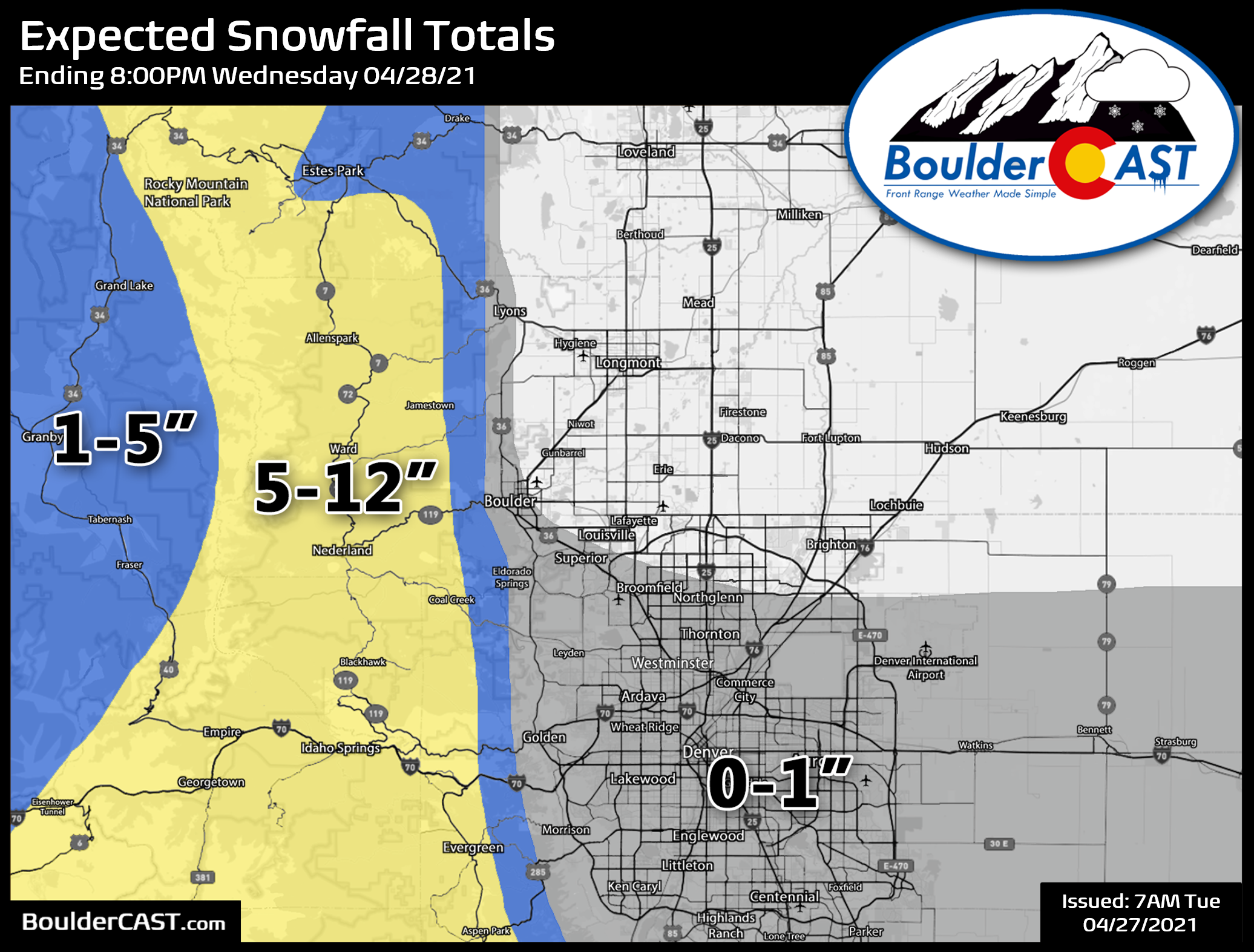
- Snowfall totals of up to 12″ are expected in the Foothills
M
ore relief for the widespread drought in northeast Colorado is on the way as a strong Pacific storm system approaches today with impacts set to linger into Wednesday. The cut-off low will drop from Nevada this morning into Arizona tonight and then across New Mexico on Wednesday.
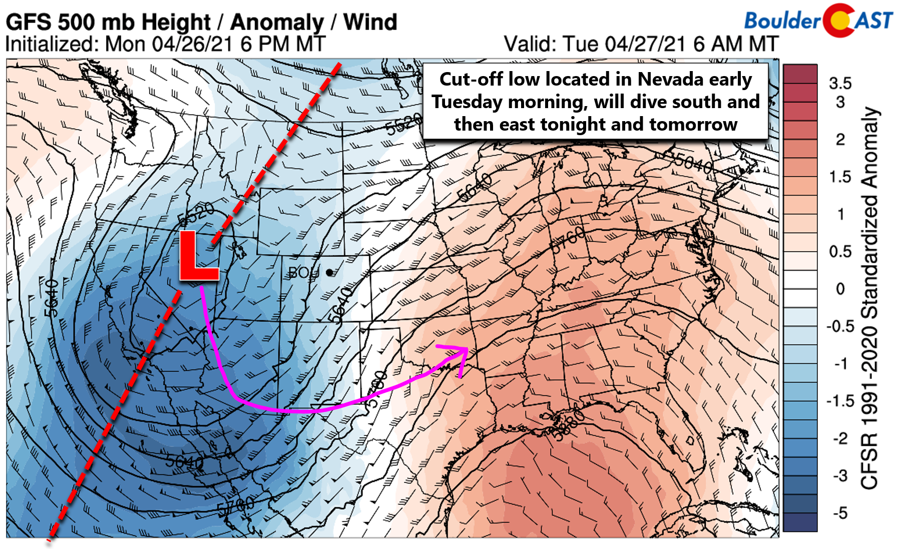
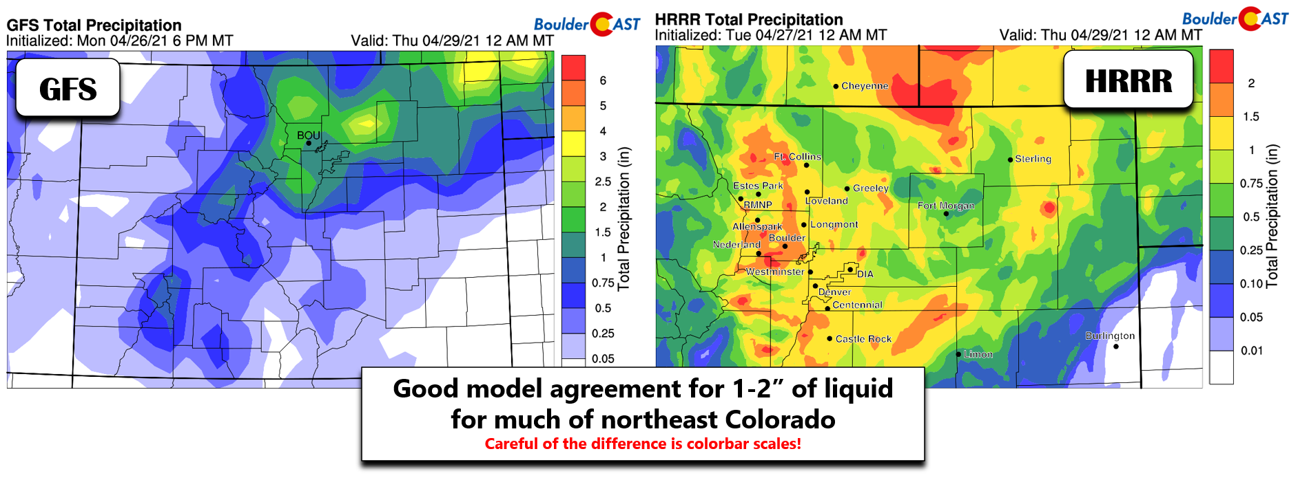
This “pivoting” track will put much of northeast Colorado in a favorable location for precipitation for an extended period of time beginning around midday Tuesday with continuous precipitation lasting into Wednesday afternoon. Global and high-resolution models alike are indicating a fair likelihood that most of the Denver Metro area will see greater than 1″ of liquid by Wednesday evening, with perhaps up to 2″ in some areas.
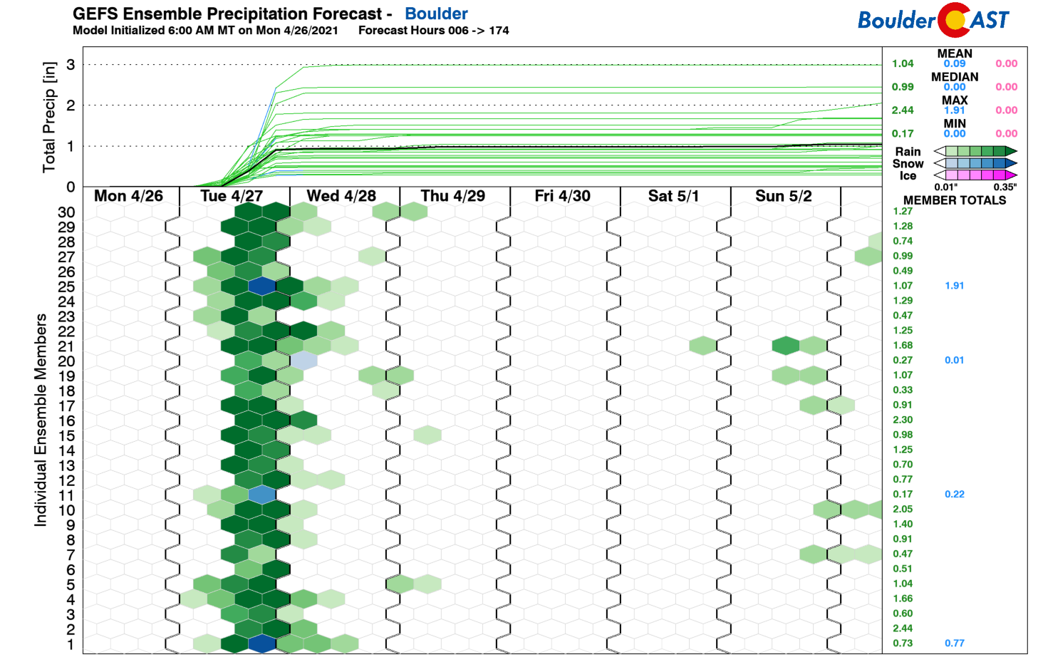
There’s still quite a bit of variation in the ensemble members, with a spread of 0.5″ to 3.0″ of liquid in Boulder (and even a few showing snow!). The ensemble mean and median are right around 1″, though.
Just for kicks, let’s take a look at the latest run of the Euro model. Yep, that’s a 3 to 4″ bullseye of rain right over Boulder and Denver. The Euro is by far the most bullish for the entire event, especially with the convection early on Tuesday afternoon and early evening. We don’t expect totals anywhere near this large, but it does give you an idea of the spring-time ingredients in play today!
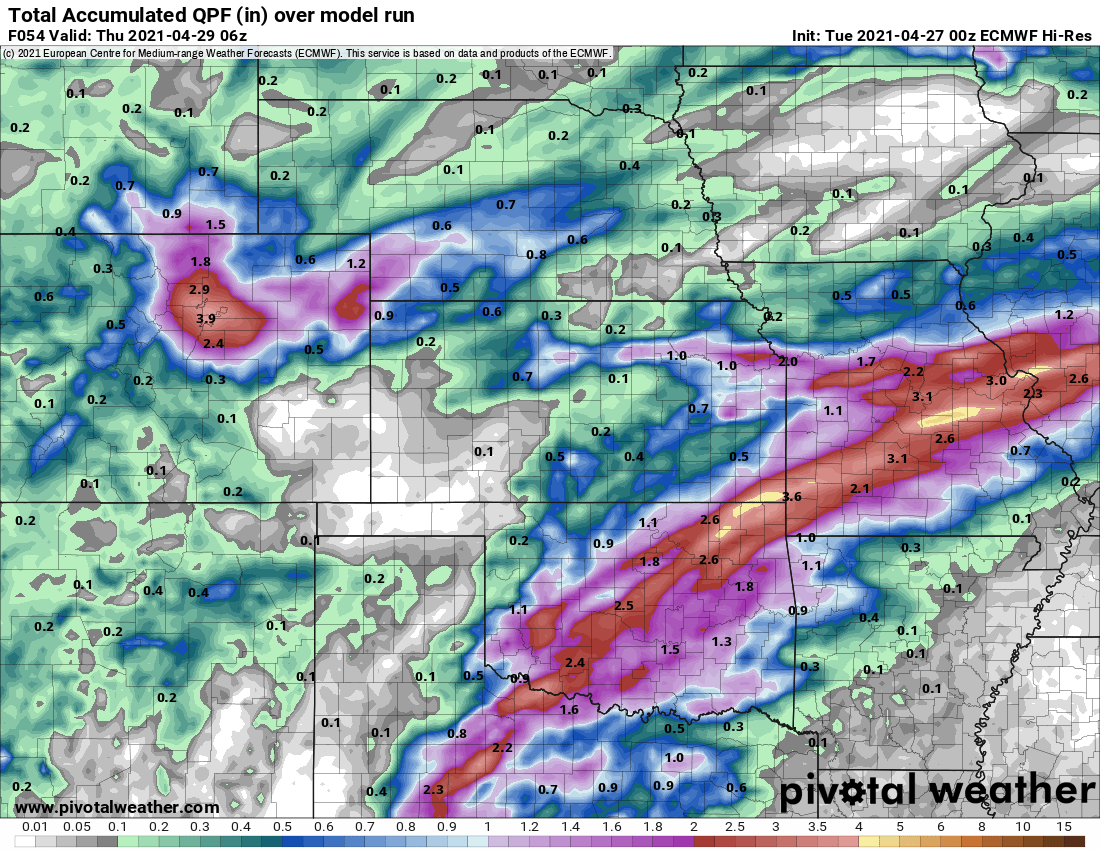
If you don’t have 2″ of rain by sunset Tuesday evening, the Euro has already busted…
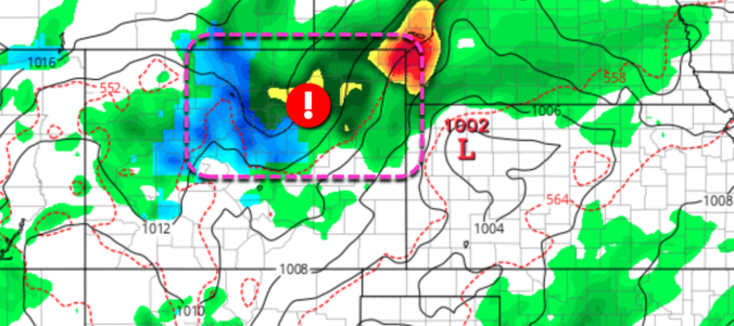
Scattered thunderstorms will develop as early as mid-day Tuesday across the Front Range along a cold front, with storms continuing through the afternoon into early evening. Some of these storms could be severe east of Interstate 25 with 1″ hail and 60 MPH wind gusts. Yes, this is the first chance of severe weather for us in 2021! As the instability dissipates, widespread light to moderate precipitation will continue through the overnight and well into Wednesday.
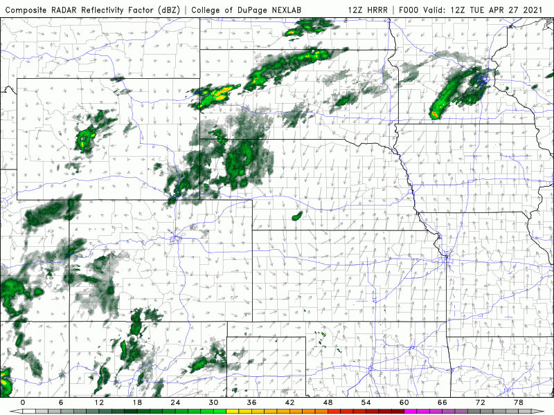
HRRR model-simulated radar animation from Tuesday morning into Wednesday afternoon
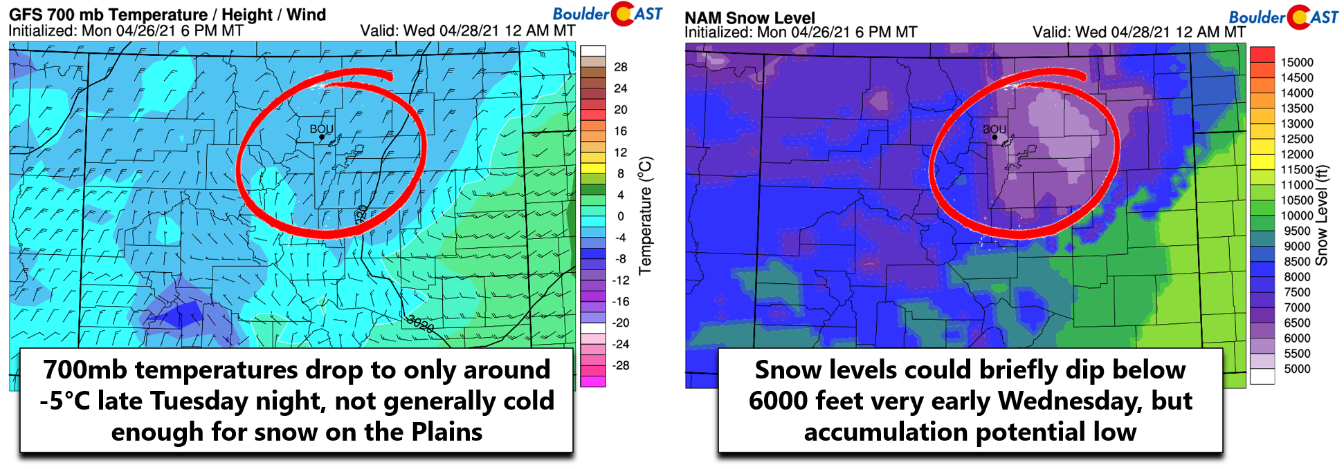
There is some cold air with this system being pulled southward, but not enough to turn rain to snow across the lower elevations, which is good thing this late in the season. 700mb atmospheric temperatures are forecast to only drop to around -3°C Tuesday night into early Wednesday (below left). This is just a degree or three too warm for snow in Boulder and Denver. However, heavy wet snow is expected higher up in the Foothills Tuesday evening into Wednesday morning where temperatures will be below freezing. Our snow-level derivations bottom out right around 5500 feet after midnight Tuesday night into early Wednesday (below right). It’s conceivable that some snowflakes could fall across the lower elevations, but these likely wouldn’t accumulate much at all.
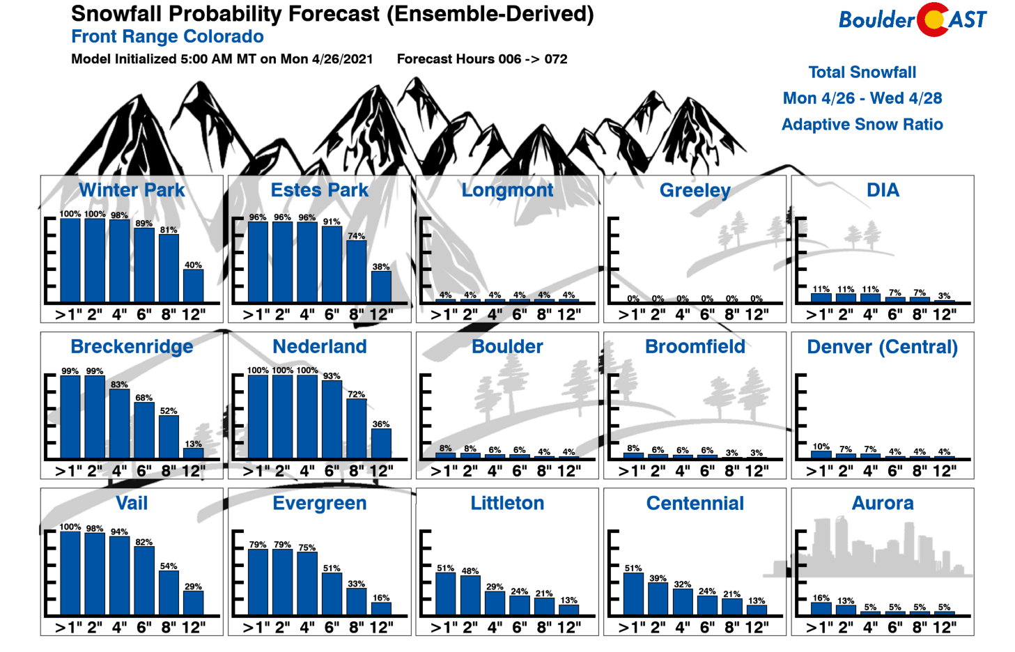
Our Snowfall Probabilities show the potential for sizable accumulations in the Foothills, with 5-12″ likely in places like Nederland. It’s also interesting to note that there are a few colder model outliers that produce some accumulating snow across the Plains (even heavy snow in some cases). The chance of this happening is very slim, though. This storm is just a few degrees too warm!
Our snowfall forecast map for the event is shown below. This covers snow falling Tuesday into Wednesday evening. Conditions will be worst in the Foothills above 7500 feet where wet snow will be falling much of the time. Watch for slushy and snow-packed roadways Tuesday night and Wednesday morning! The lower Foothills between 6000 and 7500 feet could see a dusting up to 5″ of snow (with a high dependence on elevation). Our forecast also includes a very slight chance of a few snowflakes in the western and southern Denver Metro area. We stress that the most likely scenario has just cold rain for everyone below 6000 feet, but it wouldn’t be surprising to see a few snowflakes mix in, especially across local high spots in the topography, such as Centennial, Parker, Golden, or Rocky Flats.
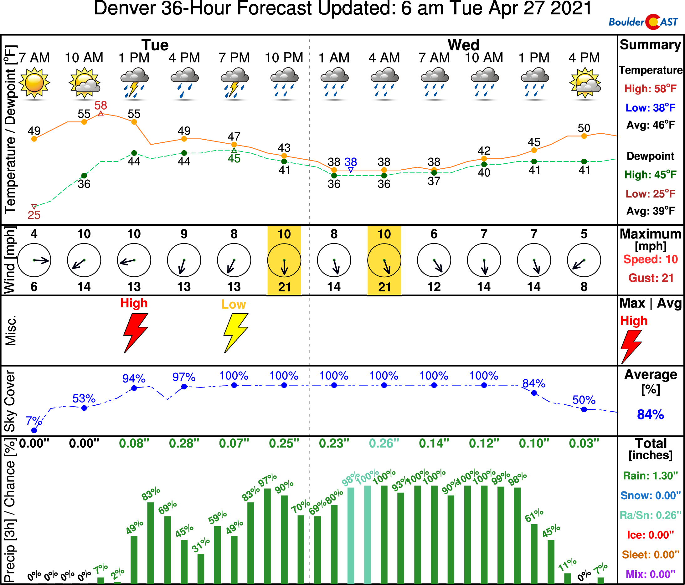
The storm timeline is shown below. Highs Tuesday will be in the 50’s with scattered thunderstorms developing quickly in the afternoon. As temperatures drop into the 40’s and eventually 30’s overnight, widespread light to moderate rain will continue, even into Wednesday afternoon.
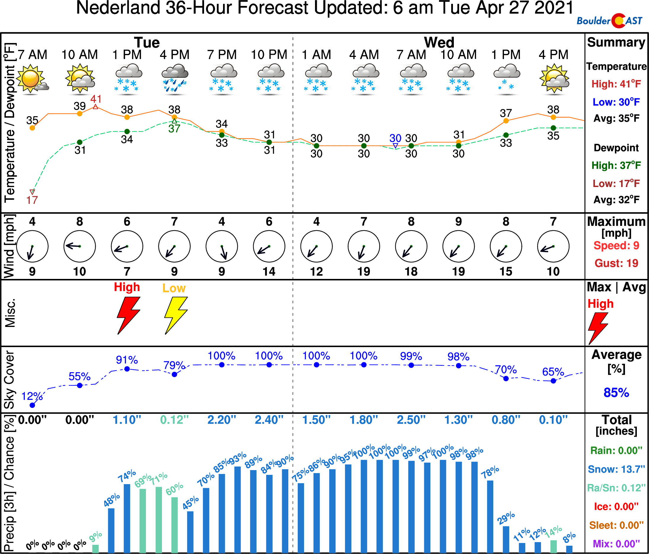
The outlook in the Foothills is much colder with temperatures starting in the 40’s and falling into the 20’s overnight. There will be a brief chance at thunderstorms Tuesday afternoon quickly changing to wet snow by early evening. Snow lingers into Wednesday afternoon.
Brace for a soggy next 24 to 36 hours in Boulder and Denver…and a blanket of wet snow in the higher hills. Gotta love spring in Colorado!
We discuss Boulder and Denver weather every single day on BoulderCAST Premium. Sign up today to get access to our daily forecast discussions every morning, complete six-day skiing and hiking forecasts powered by machine learning, access to all our Front Range specific weather models, additional storm updates and much more!
.
Spread the word, share Colorado’s crazy weather:


You must be logged in to post a comment.