In today’s forecast, we cover a quick-hitting Pacific trough set to bring cooler temperatures and gusty winds to the Metro area today. We also provide an update on the major spring storm eyeing Colorado late in the week.
TODAY’S WEATHER
A quick-moving Pacific trough will be progressing across Colorado today. The impacts will be…
- Cooler temperatures: The trough will bring a cold front through the Denver Metro area by late morning or early afternoon. Though temperatures may initially climb into the 60’s before the front passes, temperatures behind the front will drop into the upper 40’s to low 50’s through the rest of the day.
- Strong winds: Strong flow aloft, downslope winds, and subsidence after the trough passes will lead to a windy day today across the region. Gusts through the day could approach 55 mph out of the west and northwest.
- Isolated rain showers: Northwesterly downslope is generally unfavorable for precipitation east of the Continental Divide. However, the flow will be moist overall, so it won’t be surprising if a few isolated rain showers survive the descent to produce a few rain drops across the Plains. Chances are small, but the best time-frame for this would be late afternoon and early evening.
- Mountain snow: A quick 2 to 5 inches of snow are expected through the afternoon and evening hours today. There is enough instability that a few thunderstorms could form as well, potentially leading to isolated areas of very heavy (but brief) snowfall.
WATCHING THE SPRING STORM FRIDAY & SATURDAY
All eyes are starting to turn to the spring storm set to impact the Front Range later this week. As we mentioned in our weekly outlook yesterday, ingredients appear to be coming together for a very wet Friday and Saturday for our region. We still believe much of the storm will be rain across the lower elevations, with the potential for very heavy snow in the Foothills. The latest GFS total accumulated precipitation forecast has 1 to 3″ of liquid across the Metro area and much of eastern Colorado.
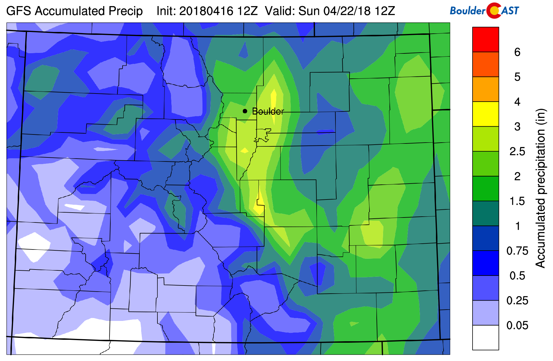
GFS total accumulated precipitation forecast for the upcoming storm.
Shown below is the GFS model 700 mb temperature and wind forecast for Saturday morning at 6:00 AM. The upslope flow into Boulder looks PERFECT…deep, strong, and due northeasterly. However, this is the coldest air indicated by the models right now…and the value is only around -5 degrees Celsius at 700 mb in Boulder. This would mean snow levels around 6,000 feet or so, equating to mostly rain for the Plains. However, given the dynamic strength of the storm, it won’t be surprising if the models trend cooler in the coming days. It may only take a degree or two to swing things towards snow. Confidence is increasing for big snow totals in the Foothills from Colorado Springs northward to the Wyoming border.
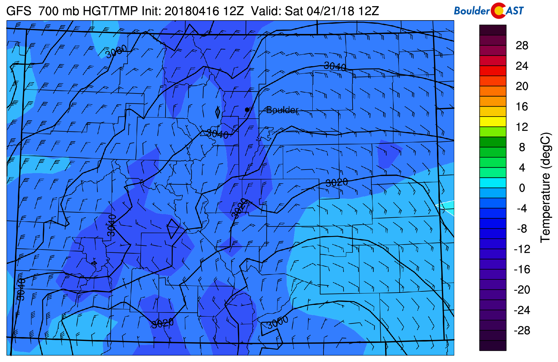
GFS 700 mb temperature and wind forecast for Saturday morning. The upslope pattern looks excellent for precipitation, though temperatures may be too warm for much snow on the Plains.
We’re still three days away, so things are likely to “wiggle” at little before the storm eventually arrives. The trend in the models has taken the track slightly further south over the last 48 hours. We’re not too concerned about this. The strength, duration, and moisture of the storm have remained relatively consistent for many days. Somewhere in eastern Colorado will see an absolute deluge of precipitation Friday and Saturday, whether rain or snow. Right now it looks like our region will at least get a piece of this action. Stay tuned through the week for updates, and also feel free to track the potential for snow yourself over on our SnowTracker page.
These detailed daily forecasts are normally only available to our Premium members. In celebration of BoulderCAST’s three-year anniversary, our daily forecasts will be available to all of our readers through Friday. During this time, use the promo code THREE at checkout to save 33% on an annual Premium membership. This offer ends Friday night at 11:59 PM Mountain Time. Sign up today to get the best BoulderCAST experience, including these daily forecasts every morning, complete 6-day skiing and hiking forecasts, chat room and forum access, early viewing of select content and much more!


You must be logged in to post a comment.