This weekend will surely feel a lot different than recent ones as the first autumn storm system of the year arrives into Colorado — conveniently aligning with the official first day of autumn on Sunday. While a fair amount of uncertainty remains in potential precipitation totals for the Front Range, everyone should see an extended period of light to moderate rainfall from late Saturday afternoon into Sunday morning. Fortunately it is still too warm for frozen precipitation across the lower elevations, but snow will fall in the Mountains accumulating up to several inches. Here’s our latest thoughts on what has turned out to be a tricky storm to forecast!

Go Premium, get all the perks.
Daily Forecast Updates
Get our daily forecast discussion every morning delivered to your inbox.
All Our Model Data
Access to all our Colorado-centric high-resolution weather model graphics. Seriously — every one!
Ski & Hiking Forecasts
6-day forecasts for all the Colorado ski resorts, plus more than 120 hiking trails, including every 14er.
Smoke Forecasts
Wildfire smoke concentration predictions up to 72 hours into the future.
Exclusive Content
Weekend outlooks every Thursday, bonus storm updates, historical data and much more!
No Advertisements
Enjoy ad-free viewing on the entire site.
UPDATED Saturday 9/21/2024 9AM: A subtle but prolific downward trend in all models for rainfall amounts was observed as the storm approaches. Thus, we have reduced predicted rainfall amounts by ~30%. See the updated rainfall map.
We first alerted you to this incoming storm system way back on Monday morning, with a clear warning that the timing and ultimate outcome from it were still quite uncertain for the Front Range. That’s not a surprise of course— the storm was a solid five days out at that point. Since then, we’ve been closely tracking this storm’s evolution through the week. Originally models were projecting a more northward track which favored Cheyenne rather than Denver. Slowly but surely, model solutions have zeroed in on a trajectory that is now much further south and more favorable for widespread soaking rains in the Denver Metro area. The storm has also slowed down considerably compared to original model projections. A slower storm should help us accumulate more rainfall, but the devil is always in the details…
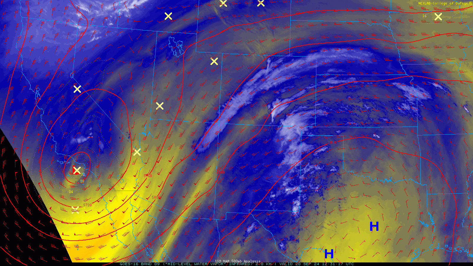
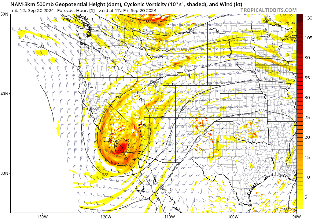
As of writing Friday afternoon, the impressive yet compact low pressure causing all the hubbub is spinning near San Diego, California. It doesn’t have a lot going on right now with the core of the low pressure surrounded by an expanse of dry air. This will change, however, as the storm heads east towards Colorado this weekend and taps into moisture from the Gulf of Mexico.
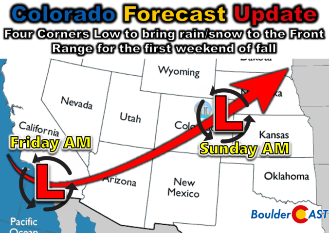
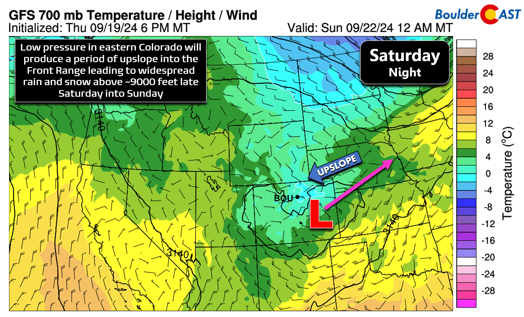
The latest model consensus is for the mid-level low to track northeastward, passing across the Four Corners Saturday evening and then into northeast Colorado by Sunday morning. This will spread large-scale lift across the entire state, and once the storm gets into position southeast of Denver, decent upslope flow will ensue across our area aiding in rainfall development.
Upslope flow will technically begin early Saturday morning as a strong cold front passes through the area from the north. This will make Saturday our coldest day in several weeks with highs only in the upper 60s or so for Denver and Boulder. However, it’s not until Saturday afternoon and evening that upslope and moisture can work in tandem. The GFS forecast graphic below shows due easterly winds above Boulder at midnight Saturday night, but only at ~15MPH. We expect to see fairly widespread light to moderate precipitation much of Saturday night as the storm slowly rakes across the Centennial State. Upslope flow will remain in-place until around midday Sunday before the storm slowly departs into Nebraska.
At this point, the track of the storm is pretty well locked in, which is good news as it has been fluctuating quite a bit in recent days. However, the exact amount of rainfall we will receive is still somewhat uncertain owing to slight differences in the wind fields generated across the Metro area from the rather petite low pressure, and how quickly the storm exits east (among other factors). For example, check out the latest European ensemble accumulated precipitation forecasts below (there are 50 member lines). There are three relatively distinct clusters of outcomes being indicated:
- Significant rain event of 2 to 3″ (10% chance)
- Large rain event of 1 to 1.5″ (40% chance)
- Medium rain event of 0.3 to 0.8″ (50% chance)
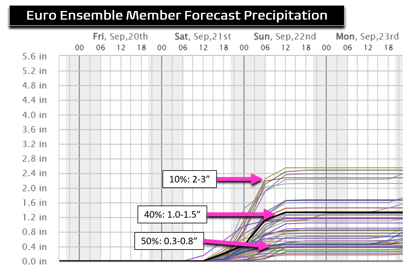
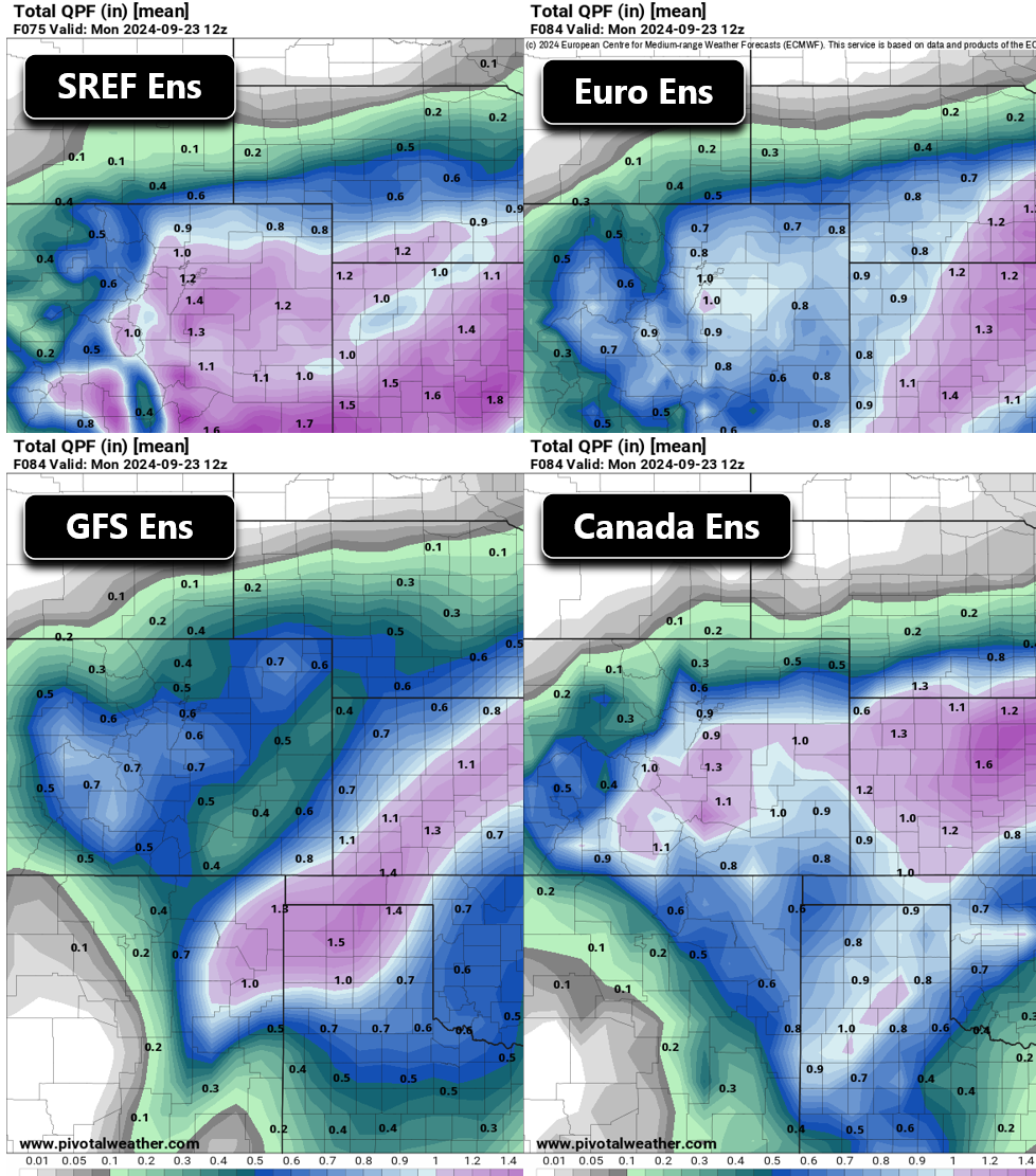
There has definitely been a trend in recent days of nixing the high-end outcomes and moving the overall average lower towards less rain. Still, this weekend’s storm should provide our area with the most significant and widespread rainfall we’ve seen in months. Given the lingering uncertainty in amounts, we’ll focus mostly on ensemble output, instead of any single model run. The mean precipitation forecast from four different ensemble suites are shown below, most of which lean towards 0.5 to 1″ of rainfall in the Denver Metro area this weekend. There is decent consistency here, but remember there are 100+ individual model runs going into these four graphics!
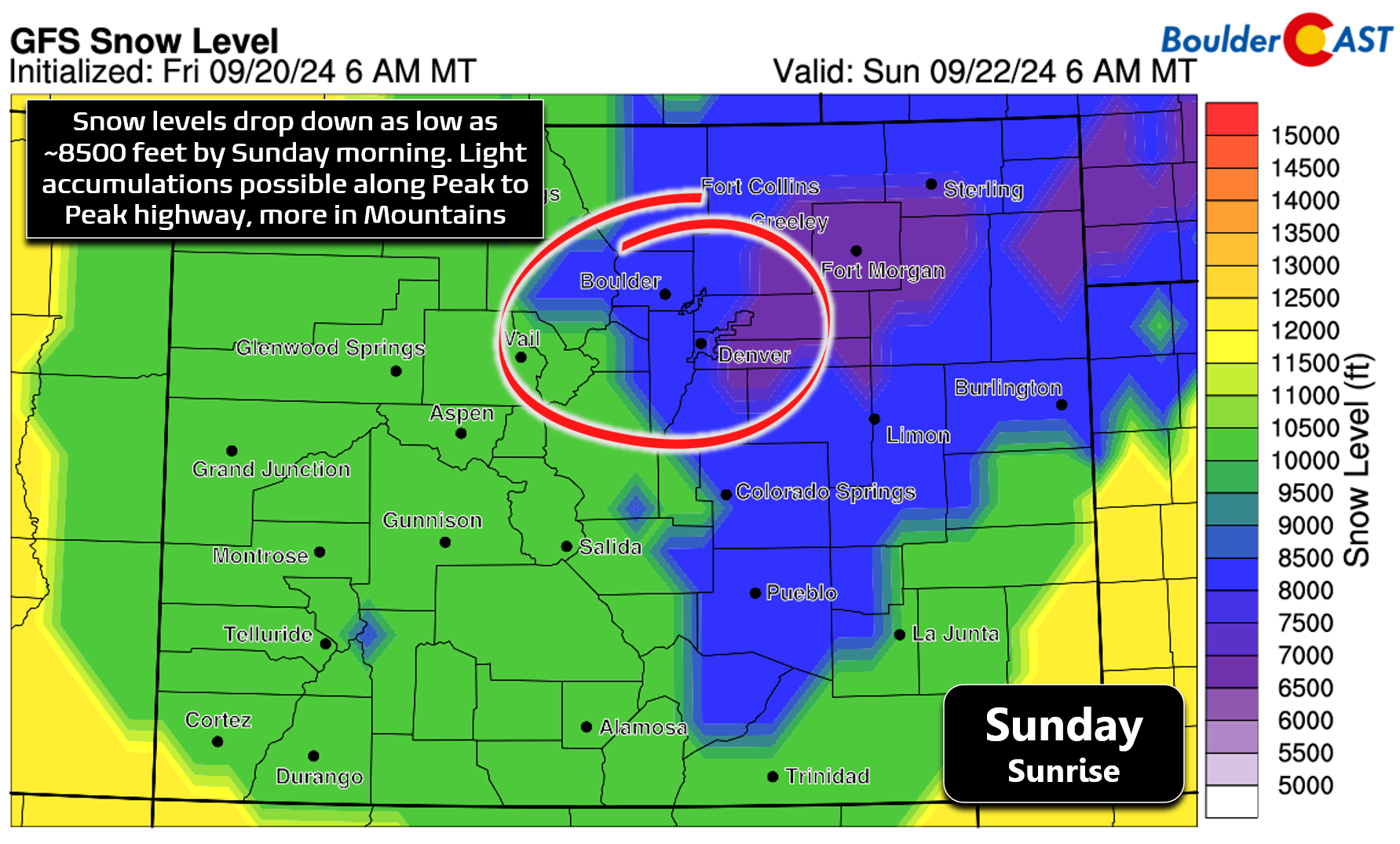
Finally, our first autumn storm wouldn’t be complete without some of the white stuff. While thankfully temperatures won’t be cold enough for snow across the lower elevations — but as you know, it is certainly possible this time of year — it will be cold enough for snow in the Mountains and highest Foothills this weekend. Snow levels are projected to drop down to around 8500-9000 feet late Saturday night into Sunday morning. Several inches of accumulation will be possible, especially above 10,000 feet on east-facing slopes of the Continental Divide. If you’re headed up to do some leaf peeping this weekend, plan to encounter wet and/or snowy conditions, though in general pass-level roads should remain mostly just wet or slushy.
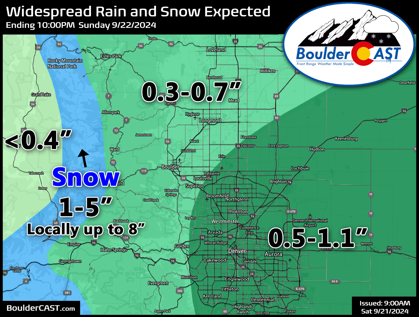
Our expected precipitation total forecast map is shown below (Updated!). Most of us should see anywhere from 0.3 to 1.1″ of rainfall this weekend, with the highest totals favored from Denver east and south. Boulder is most likely to receive 0.3 to 0.6″ of rain. The Mountains can expect 1 to 5″ of fresh snow above 9000 feet with locally up to 8″. It will be drier west of the Divide with too warm of temperatures for snow leading to mostly rain showers over there in places like Granby and Grand Lake.
Here’s the current forecast timeline:
- Friday: Morning high clouds becoming sunnier eventually with a high temperature in the mid to upper 80s.
- Saturday: Sunny skies in the morning becoming overcast during the day. A pre-dawn cold front will tumble temperatures, topping out only in the upper 60s by afternoon. North and northeast winds will be gusty at times up to 20 MPH. Rain showers, with perhaps a few rumbles of thunder, will spread into the area by early evening, with widespread light to moderate stratiform rain continuing through the overnight.
- Sunday: Widespread light to moderate rain in the morning (snow in the Mountains), with rain becoming more scattered throughout the day, fully ending during the afternoon or early evening. There could be some blue skies before sunset but don’t count on that. Temperatures struggle and likely fail to get out of the 50s during the day.
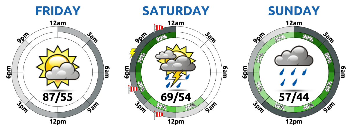
Though it will be chilly and breezy behind a cold front, Saturday morning will probably offer the best weather conditions for outdoor activities the entire weekend. Keep that in mind if you’re planning any leaf-peeping adventures or trying to squeak out just one more 14er this year. That’s all for now. Enjoy the wet weather accompanying the changing seasons this weekend! The first snow for the lower elevations is climatologically becoming more likely with each passing day…
Get BoulderCAST updates delivered to your inbox:
Go Premium, get all the perks.
Daily Forecast Updates
Get our daily forecast discussion every morning delivered to your inbox.
All Our Model Data
Access to all our Colorado-centric high-resolution weather model graphics. Seriously — every one!
Ski & Hiking Forecasts
6-day forecasts for all the Colorado ski resorts, plus more than 120 hiking trails, including every 14er.
Smoke Forecasts
Wildfire smoke concentration predictions up to 72 hours into the future.
Exclusive Content
Weekend outlooks every Thursday, bonus storm updates, historical data and much more!
No Advertisements
Enjoy ad-free viewing on the entire site.
Enjoy our content? Help us out and give it a share:


You must be logged in to post a comment.