Category: Winter Weather (Page 38 of 134)
These posts contain some discussion of the white stuff, whether it be mountain snow pack or a Front Range snowstorm.

The cold front which will initiate the bands of snowfall Friday night is still located approximately 150 miles north of Denver but it is heading this way quickly. We discuss the latest on the approaching system and provide a few final details on timing for what should be a widespread light accumulation of snow for everyone overnight.

As our snow season begins to wind down across the Front Range, our Winter Storm Updates are arriving to your inbox less and less. However, an interesting setup knocking on the door will create a quick chance of banded snowfall Friday night with everyone poised to see some white stuff accumulate. Let’s discuss the latest on the approaching snow bands including their timing, travel impacts and ultimately how much snow will stick.
The week starts off rather warm under increasingly strong southwest flow aloft. This will culminate in elevated fire danger on Tuesday with dry and gusty winds in place. The mid to late week period will turn unsettled and much colder with a series of low pressure systems and cold fronts lining up that will bring at least two chances for Front Range rain and snow during the period. Read on for more details.
The cold front has moved through overnight and temperatures have tumbled considerably. Rain and snow showers are already beginning to develop across the area and this trend will continue through the day. We discuss the latest on the approaching storm and provide some final details on what should be a rather soggy and/or snowy next 18 hours depending on your elevation.
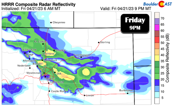
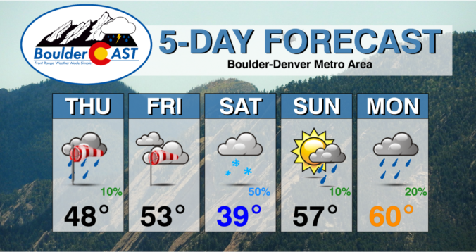
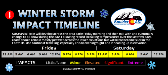
We hope you enjoyed the taste of summer as temperatures soared into the 70s and 80s the last several days because we will be paying for that warmth in short order as much colder temperatures and snowflakes take over the Front Range to end the week. A tricky forecast is set to unfold over the area Friday into Saturday with rain changing to wet spring snow for everyone. Up to 10″ could fall in the higher Foothills communities with even slushy accumulations on the table for the Denver-Boulder area. Let’s discuss the latest on the approaching winter storm.

Live View of Boulder

Current Conditions

Live Radar

Recent Premium Posts

BoulderCAST Daily – Fri 01/16/26 | High wind event gives northeast Colorado a rare day with critical fire danger AND cold temperatures–stay weather aware!
🌡️ Cold front crash‑landing: Temps plunged ~20° in minutes last night as a …
BoulderCAST Daily – Thu 01/15/26 | Fire Danger Today Before a Cold Front Tonight
🔥 Fire danger rising — Warm and windy today ahead of a strong …
BoulderCAST Daily – Wed 01/14/26 | A gorgeous Wednesday ahead of increasing fire danger & a stronger cold front tomorrow
🌬️ Weak front overnight — A weak cold front slipped through around 9:30 …
3-Day Forecast

Trending Content

© 2026 Front Range Weather, LLC