
A recap of yesterday’s hailstorms, a discussion of today’s forecast which contains more hail, and a look at the eye of Category 4 Hurricane Bud from GOES-16.
Category: Severe Weather (Page 19 of 21)
The posts contain discussion of severe weather in our region, including forecasts, outlooks, and recaps of events involving large hail, damaging winds, and tornadoes.

The weather pattern for the week ahead will exhibit shades of the middle of summer with a ridge of high pressure parked across the south-central United States. As a result, temperatures in the Metro area will soar into the 90’s with only limited chances for rainfall through the week. This forecast doesn’t bode well for the meager snowpack remaining across the High Country.
Premium Storm Update (Thu May 3 at 6:00 AM) Strong cyclogenesis and upslope: Moderate lower elevation rain and heavy snow in the Foothills is falling this morning as 40 mph upslope briefly surges into the Metro area. READ NOW
—
We provide a quick forecast update as a vigorous storm system bears down on Colorado. Our forecast includes widespread soaking rain, borderline severe thunderstorms, and a snowfall forecast map for the higher elevations.
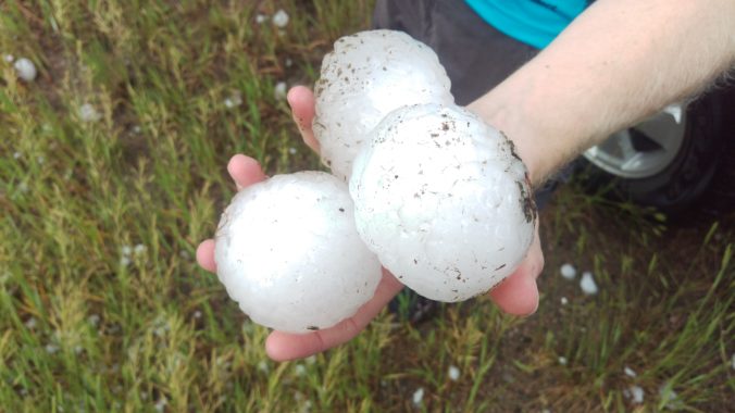
On May 8th 2017, a severe thunderstorm formed over the western suburbs of Denver around 2:30 PM Mountain Time. Hailstones up to 2.75″ in diameter pummeled cars and structures causing a total of $1.4 Billion (that’s billion with a “B”!) in damage, thereby becoming the costliest hailstorm in state history. We take a look back at this historic storm, and give you warning of the impending insurance spikes for 2018.
After record-setting heat the last two days, the first wave of cooler air arrives early this afternoon. Then, an actual cold front is set to move in later tonight. Before that however, we’ll have to survive a few hail-producing severe storms this afternoon.

Our weather this week will be typical for mid-June. The initial focus will be the threat of severe thunderstorms Monday afternoon and evening, with tornadoes a viable concern. This will be followed by sunny and warm weather the rest of the week. High Country conditions will be exceptional this week, too.

May 2017 has already cracked the top 10 for wettest Mays on record in Boulder. Unfortunately, this trend looks to continue right until the end of the month. Read on for the soggy details as we provide our complete forecast for Memorial Day weekend.

Live View of Boulder

Current Conditions

Live Radar

Recent Premium Posts

BoulderCAST Daily – Tue 06/02/26 | Storms Reload This Afternoon, But With Noticeably Less Bite
❄️ Monday delivered lots of hail to northeast Colorado, with one supercell tracking …
BoulderCAST Daily – Sun 05/31/26 | Dry and warm today but rain chances increase this week
🌦️ Overall dry and warm Sunday, though cannot rule out a very widely …
BoulderCAST Daily – Sat 05/30/26 | A stray shower today as most activity resides well east of Denver
🌦️ Spotty showers today, mainly well east of the Denver Metro area, where …
3-Day Forecast

Trending Content

© 2026 Front Range Weather, LLC