


Category: Severe Weather (Page 20 of 22)
The posts contain discussion of severe weather in our region, including forecasts, outlooks, and recaps of events involving large hail, damaging winds, and tornadoes.
Premium Storm Update (Thu May 3 at 6:00 AM) Strong cyclogenesis and upslope: Moderate lower elevation rain and heavy snow in the Foothills is falling this morning as 40 mph upslope briefly surges into the Metro area. READ NOW
—
We provide a quick forecast update as a vigorous storm system bears down on Colorado. Our forecast includes widespread soaking rain, borderline severe thunderstorms, and a snowfall forecast map for the higher elevations.
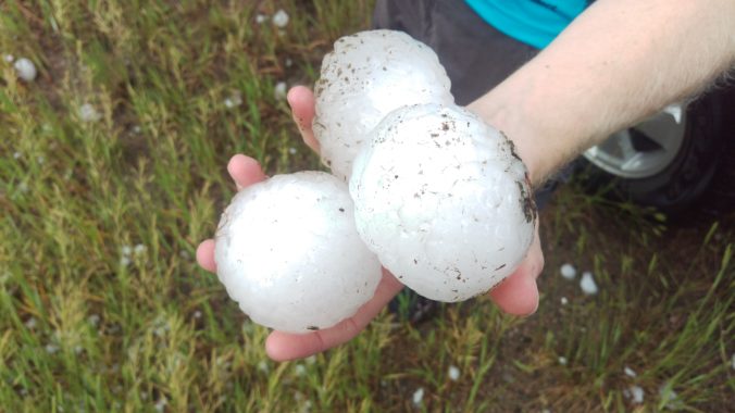
On May 8th 2017, a severe thunderstorm formed over the western suburbs of Denver around 2:30 PM Mountain Time. Hailstones up to 2.75″ in diameter pummeled cars and structures causing a total of $1.4 Billion (that’s billion with a “B”!) in damage, thereby becoming the costliest hailstorm in state history. We take a look back at this historic storm, and give you warning of the impending insurance spikes for 2018.
After record-setting heat the last two days, the first wave of cooler air arrives early this afternoon. Then, an actual cold front is set to move in later tonight. Before that however, we’ll have to survive a few hail-producing severe storms this afternoon.

Our weather this week will be typical for mid-June. The initial focus will be the threat of severe thunderstorms Monday afternoon and evening, with tornadoes a viable concern. This will be followed by sunny and warm weather the rest of the week. High Country conditions will be exceptional this week, too.

May 2017 has already cracked the top 10 for wettest Mays on record in Boulder. Unfortunately, this trend looks to continue right until the end of the month. Read on for the soggy details as we provide our complete forecast for Memorial Day weekend.
Our rainiest month has delivered this week with beneficial moisture falling across all of the Front Range. And of course, let’s not forget Monday’s insane hailstorm in downtown Denver, Lakewood, and Arvada. Here are cumulative rain totals this week through 7:00 AM Thursday:
- Boulder – 1.80″
- Golden – 1.72″
- Nederland – 1.45″
- BoulderCAST Station – 1.39″
- Downtown Denver – 1.30
- Broomfield – 0.95″
- Louisville – 0.89″
- Longmont – 0.75″
- Denver Int’l Airport – 0.75″
With three and a half “days of Seattle” out of the way, we’ll revert to “typical Colorado” in short order. Sunshine returns and temperatures rebound to near 80 degrees tomorrow and into the weekend.

Our weather turned quite warm to end the week, with Friday, Saturday and Sunday well above average in the 80’s across much of the Metro area. Unfortunately, this week will see a gradual drop in temperatures all thanks to a large cut-off low pressure system churning slowly across the Desert Southwest. It also looks to be a wet week overall, especially Tuesday and Wednesday. All the details can be found in our week ahead outlook, so read on…

Live View of Boulder

Current Conditions

Live Radar

Latest Smoke Forecast

Recent Premium Posts

BoulderCAST Daily – Fri 08/28/26 | The 90s Continue with Isolated Afternoon Storms Through the Weekend
☁️ Daily isolated storms this weekend with cloudy skies: Activity will be isolated …
This Weekend in Colorado Weather: Storm Chances Shrink While Heat Surges Into the Weekend
🌧️ Monsoon finally delivered Wednesday: Boulder and Denver both snagged a bout of …
BoulderCAST Daily – Wed 08/26/26 | Front Range Braces for a Few Severe Storms with Large Hail Today
🌩️ Severe storms possible — We’re still looking at scattered thunderstorms developing later …
3-Day Forecast

Trending Content



© 2026 Front Range Weather, LLC