Category: Monsoon (Page 11 of 12)
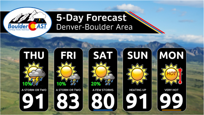
Get ready for summer! A largely hot and dry forecast will be in the cards this week as an anomalous ridge of high pressure develops to our south pumping in air from the Deserts. There will be a few chances for isolated storms, with the best chance coming towards week’s end as a frontal system tries to make its way into the area from the north. Read on for details as the first “heatwave” of 2023 unfolds across the Front Range.
After a hot and dry Monday, the rest of the week ahead will see cooler and stormy conditions unfold across the Front Range, the the focus centered on another damaging hail outbreak on the Fourth of July holiday. Much cooler weather arrives Wednesday with at least one cold-related historical record up for grabs. The Southwest monsoon remains delayed with little hope of it arriving anytime soon. Let’s take a look at yet another active week in Colorado weather!
Whether you like it or not, Front Range Colorado has finally turned a corner on the cool and soggy weather lingering across the area the last few months — just in time for the first day of summer on Wednesday! While the week ahead will offer a few chances for rain, and even some severe storms at times, the overall trend heading into the end of June will be towards drier and hotter weather. Let’s take a look!

Hint: All of the clues are related to Boulder, Denver, and/or Colorado weather. OK, well most of the clues…

August 2022 followed the trend of the rest of the summer as another hot and somewhat dry month across the Front Range. August began very warm, cooled off around the middle of the month as monsoon moisture surged, and finally once again turned toasty by months’ end. Here’s a quick and colorful graphical recap of our weather during August and how it relates to climatology.
After a couple cooler weeks, a new ridge of high pressure will form over Utah and dominate the extended forecast across the Front Range leading to a lengthy stretch of 90-degree days accompanied by little to no rainfall. The upcoming Labor Day weekend looks pretty nice across the area as the warmth continues but with some storms popping up in the Mountains. Let’s take a look at the weather week ahead.
Drier weather takes hold for most of the Front Range through about midweek as high pressure and reduced moisture move in. The latter half of the week will feature an uptick in storm chances with a series of disturbances moving into the area. Temperatures will largely stay close to normal in the 80s as monsoon season comes to an end for northeast Colorado. Read on for more details.

Live View of Boulder

Current Conditions

Live Radar

Recent Premium Posts

BoulderCAST Daily – Sat 05/02/26 | A pleasant and warm first weekend in May
☀️Warming up for the first weekend in May, with upper 60s to near …
BoulderCAST Daily – Fri 05/01/26 | Warming up this weekend
🌡️ Warming up this weekend, from the upper 50s-60 today to the upper …
BoulderCAST Daily – Tue 04/28/26 | Staying cool with a couple showers, the late-week storm is still the main event despite trending south
🌧️ Morning wave = main show, with light rain showers and Foothills wet …
3-Day Forecast

Trending Content

© 2026 Front Range Weather, LLC