The week ahead will feature persistent northwest flow across the northern Rockies which will keep things sunny, mostly dry and generally mild for us in the Front Range. Overall temperatures will be up and down with the only chance of rain for the week coming late in the day Tuesday. There’s no snow in the pipeline either, but frost will be possible Thursday morning especially in outlying areas. Read on for our complete outlook of the weather week ahead.
Category: Forecast (Page 62 of 169)
The first full week of October will feature a few cold frontal passages, one in the beginning and another toward the end. Both will be accompanied by the chance of rain showers and below normal temperatures. In between these two systems, drier weather and near seasonal conditions will be the norm under weak ridging aloft. Sorry folks! There’s still no snow nor any freezing temperatures in the pipeline for the Denver Metro area. Read on for more details.
The first full week of autumn will be rather tame across the Front Range. A ridge of high pressure will provide warm and mostly dry conditions through Thursday for the area, but a storm system is eyeing the region Friday into Saturday with rain and some Mountain snow on the way. Read on for all the details.
Get ready — we’ll have shades of both summer and fall this week! An anomalous ridge of high pressure over the southern Great Plains will lead to a dry and hot first few days. However, a strong storm system out West and its attendant cold front will bring well below normal temperatures and rain showers Wednesday into Thursday, our first taste autumn perhaps. The late-week period will turn more seasonal for Colorado. Read on for all the details.
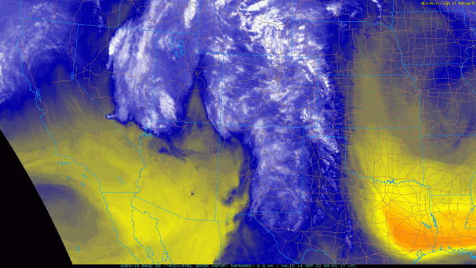
⦁❶⦁ Remnant tropical moisture from once-Hurricane Kay is fully-entrenched across the state today
⦁❷⦁ Widely scattered afternoon and evening showers and storms expected with highs around 80 degrees
⦁❸⦁ The moisture lingers through Friday and so too will the (slight) rainfall chances
⦁❹⦁ A deep trough develops along the West Coast this weekend but it may never reach Colorado
After setting multiple record high temperatures during the heatwave last week followed by a pleasantly cooler weekend, this week our temperatures will stay mostly above normal with some chances for rain mixed in as the remnants of Hurricane Kay pass across the Rockies. The week will end warm and mostly dry with that same trend continuing through the upcoming weekend. Let’s take a look at the weather week ahead for the Front Range.
The extreme heatwave unfolding across the West continues in full-force for one more day in Colorado. Unfortunately, the hottest temperatures thus far still lie ahead on Thursday alongside elevated fire danger. The end is in sight though — two cold fronts bring a taste of autumn this weekend. We discuss how hot it will get Thursday, the timing of the big changes, and just how chilly it will be this weekend.
The ongoing brutal heatwave will continue for Labor Day and through the first full week of September. A strong and anomalous ridge parks itself over the Utah region through Thursday resulting in hot and dry weather in the 90s across the Denver area. Record highs are likely under this setup and we may even see some triple digits at times as well. The light at the end of the tunnel is a welcomed cold front currently scheduled to arrive on Friday.

Live View of Boulder

Current Conditions

Live Radar

Latest Smoke Forecast

Recent Premium Posts

BoulderCAST Daily – Wed 07/15/26 | The Ridge Rules the Rockies as Hot, Dry Pattern Holds Firm
🔥 Heat dome setup continues — A strong, stationary 500 mb ridge keeps …
BoulderCAST Daily – Tue 07/14/26 | The Front Range Continues to Bake Under Expansive Ridge
🔥 Heat streak continues — Boulder hit 97°F for the third time in …
BoulderCAST Daily – Sun 07/12/26 | Hot weather for a good chunk of the coming week
🥵 🔥 Heat for a good chunk of the week: Upper 90s through …
3-Day Forecast

Trending Content

© 2026 Front Range Weather, LLC