The first full week of October will feature a few cold frontal passages, one in the beginning and another toward the end. Both will be accompanied by the chance of rain showers and below normal temperatures. In between these two systems, drier weather and near seasonal conditions will be the norm under weak ridging aloft. Sorry folks! There’s still no snow nor any freezing temperatures in the pipeline for the Denver Metro area. Read on for more details.
This week’s highlights include:
- Two cold fronts will impact the Front Range in the extended — one on Monday and another late in the week
- The two frontal passages will warrant chances of rain/showers, along with below normal temperatures in the 50s and 60s
- Drier weather takes hold Wednesday and Thursday as weak ridging aloft develops to our west — this will spell out a short warming trend as well
- The late-week cold front could usher in low clouds, drizzle, and highs in the 50s
DISCLAIMER: This weekly outlook forecast is created Monday morning and covers the entire upcoming week. Accuracy will decrease as the week progresses as this post is NOT updated. To receive daily updated forecasts from our team, among many other perks, subscribe to BoulderCAST Premium.

Cold front #1 moves in tonight
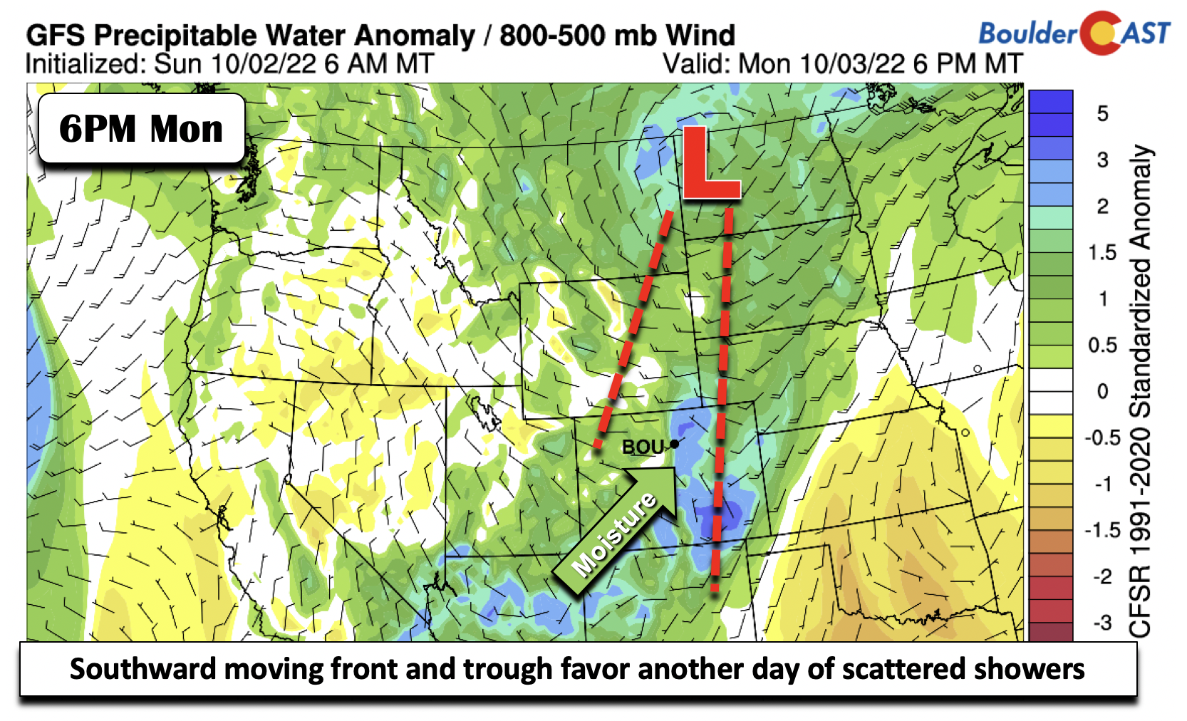
The pesky trough that has been to our west-northwest the entirety of this past weekend is still over the region, currently over eastern Montana. A shear axis extends from the trough into western Wyoming and eastern Utah to northwest Arizona. Thus, with the axis still needing to push through to the east, we’ll again be somewhat unsettled Monday afternoon/evening. The axis will move east on Tuesday, leading to a drier trend in the forecast.

As expected, moisture remains elevated across the state ahead of the trough axis on Monday. Precipitable water reaches some 0.7 inches by late afternoon, well above the daily normal of 0.4 inches and slightly above the 90th percentile of 0.64 inches.
Temperature-wise, there is a cold front that will drop down through the area from Wyoming tonight. This is tied to a weak low pressure in central North Dakota. A surface trough is also present in far eastern Colorado and western Nebraska. Clouds will be fairly prevalent Monday but there will be some early-day breaks of sunshine. Highs will be close to normal in the upper 60s in Boulder to the low 70s in Denver.
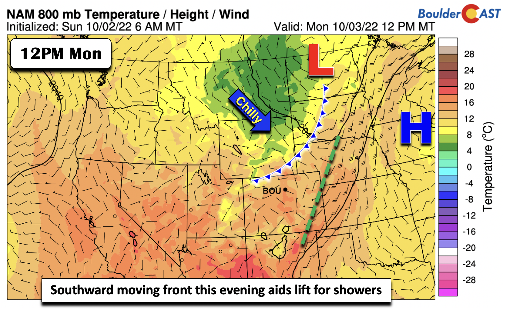
As for precipitation chances with the trough and front, the pattern is kinda messy in the sense that there are multiple surface boundaries that could initiate showers. The first is the cold front to our northwest, that should fire scattered showers from the northwest, tracking east-southeast Monday afternoon/evening. How much of this holds together as it crosses the Continental Divide is unclear. A secondary trough boundary to our east may also produce isolated showers but that will be far removed from us. Our main forcing will be the northwestern front and mid-level trough, combined with weak surface instability. We don’t expect a widespread rain as a result Monday afternoon/evening, but it’s still a decent chance of rain at 30-40%. Any showers will weaken by late evening. There could be a few rumbles of thunder mixed in as well with small hail and brief moderate rainfall.
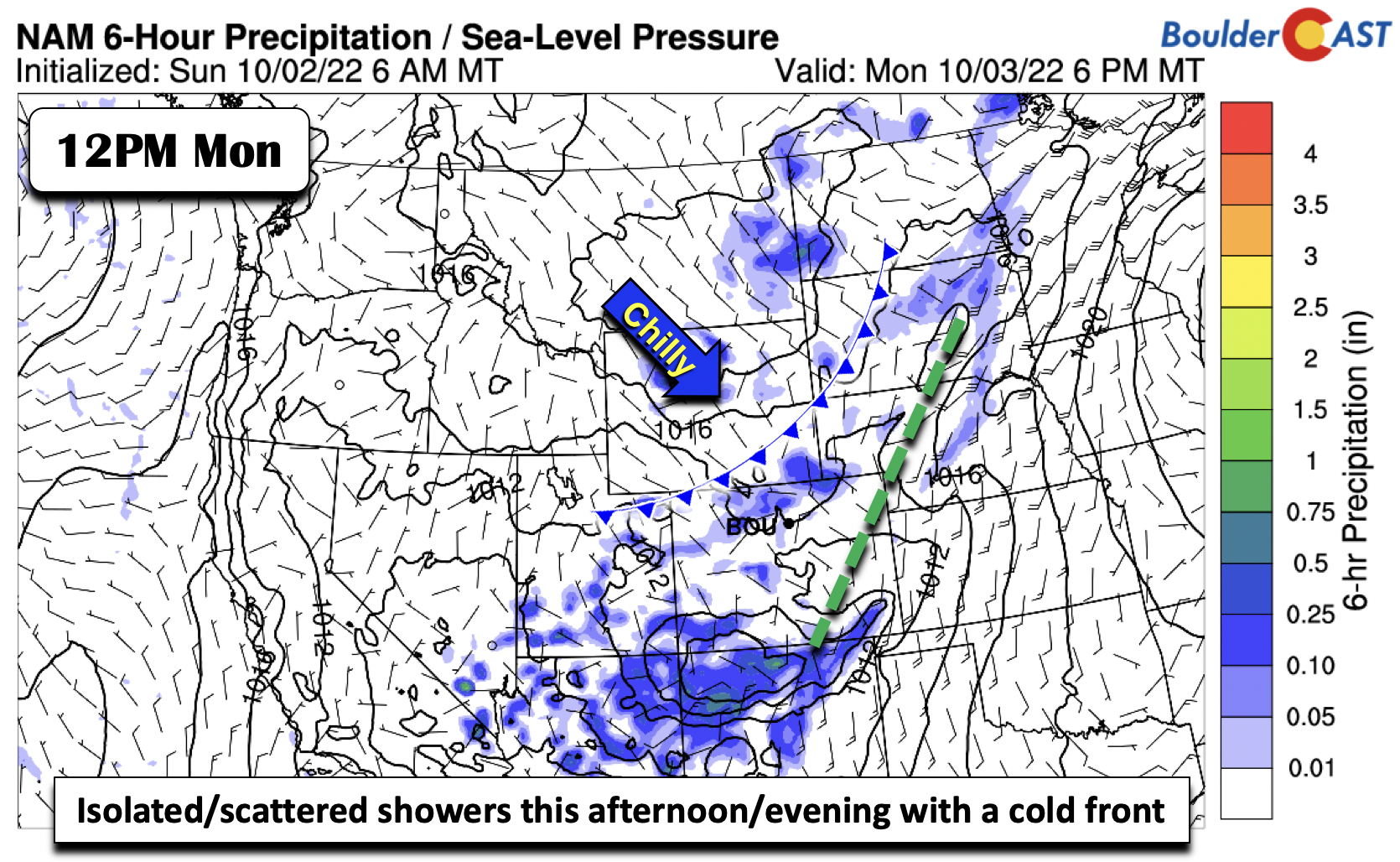
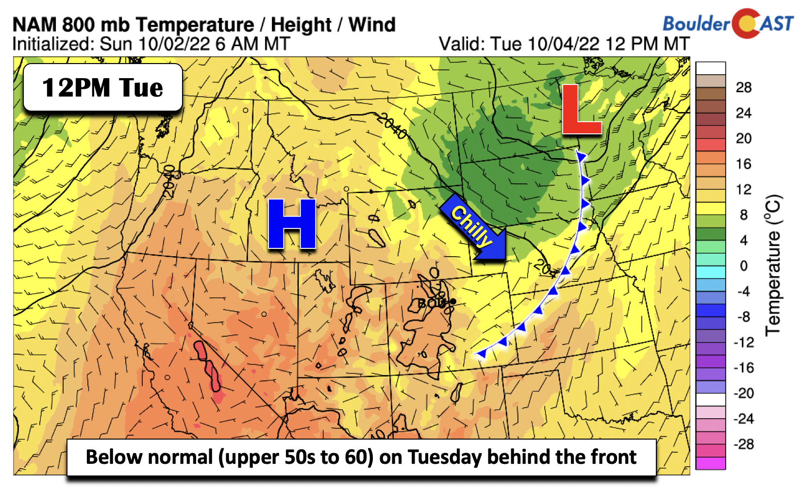
The front pushes through Tuesday, settling along southeast Colorado and eastern Nebraska, as the surface low moves into northwest Minnesota. Upslope flow on the Front Range will make for a chilly day some 10 to 12°F below normal in the upper 50s to around 60 degrees. Morning clouds and some patchy drizzle should trend toward drier conditions and more sunshine for the afternoon. There is a slight chance (10-20%) of some afternoon light showers with the upslope, but most of us should stay dry.
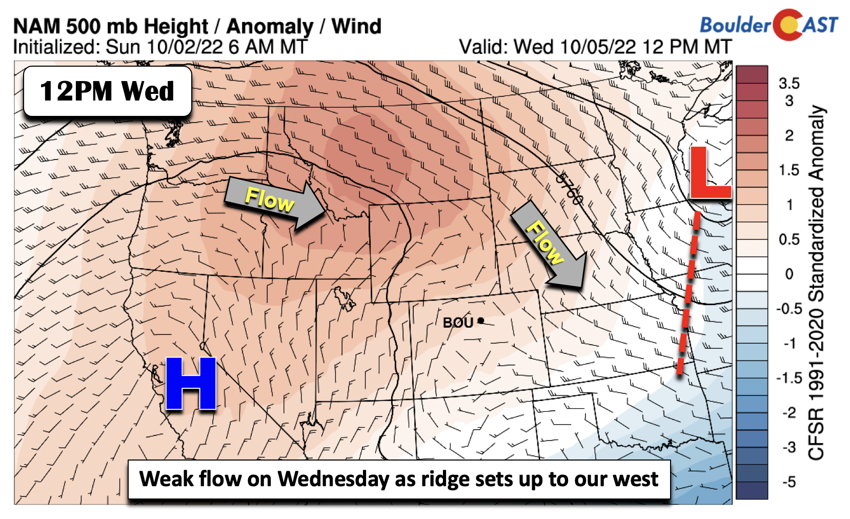
Slight warming trend come midweek
By Wednesday, the mid-level trough shifts into the Mississippi Valley. Hooray! A weak mid-level ridge develops over California and extends into Montana. Colorado will more or less be situated between the ridge and the trough with weak flow out of the east-northeast. So while this will favor a warming/drying trend Wednesday into Thursday with highs reaching the upper 60s to lower 70s and back to normal, it won’t be a big warm-up for us with the lack of strong warm air advection from the south or southwest.
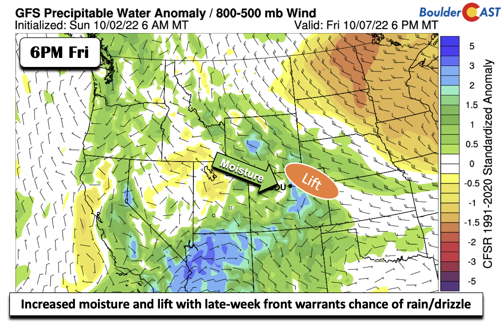
Cold front #2 may be quite chilly with light rain/drizzle
Our second cold front of the week is currently poised to move through late Thursday to early Friday. A deep and elongated trough is forecast by the models to extend from the upper Great Plains/central Canada into the Mid-Atlantic by early Friday. That will bring in increasing northwest flow aloft into our region and allow a front to slide down from the east-northeast. Usually these cold fronts under this pattern move through faster than anticipated so we can’t fully time it just yet — just know that sometime Thursday seems most favored right now.

At the low-levels by midday Friday, the front will extend from the Front Range into the Mid-Mississippi and Ohio Valleys to the northeast US. Unseasonably chilly temperatures will follow over most of the areas north of this boundary, including northeast Colorado.

Anomalies from the ECMWF on Friday indicate the potential for highs to be well below normal, possibly only in the middle 50s or cooler.

The ECMWF and Canadian guidance is a tad stronger with an impressive surface high (1040 mb) settling into the Dakotas by Friday. The GFS is a shade weaker at 1036 mb and is not as far south with the position, which is why it is warmer than the other guidance for high temperatures. We are following the cooler side of guidance given better agreement with the ensemble data.
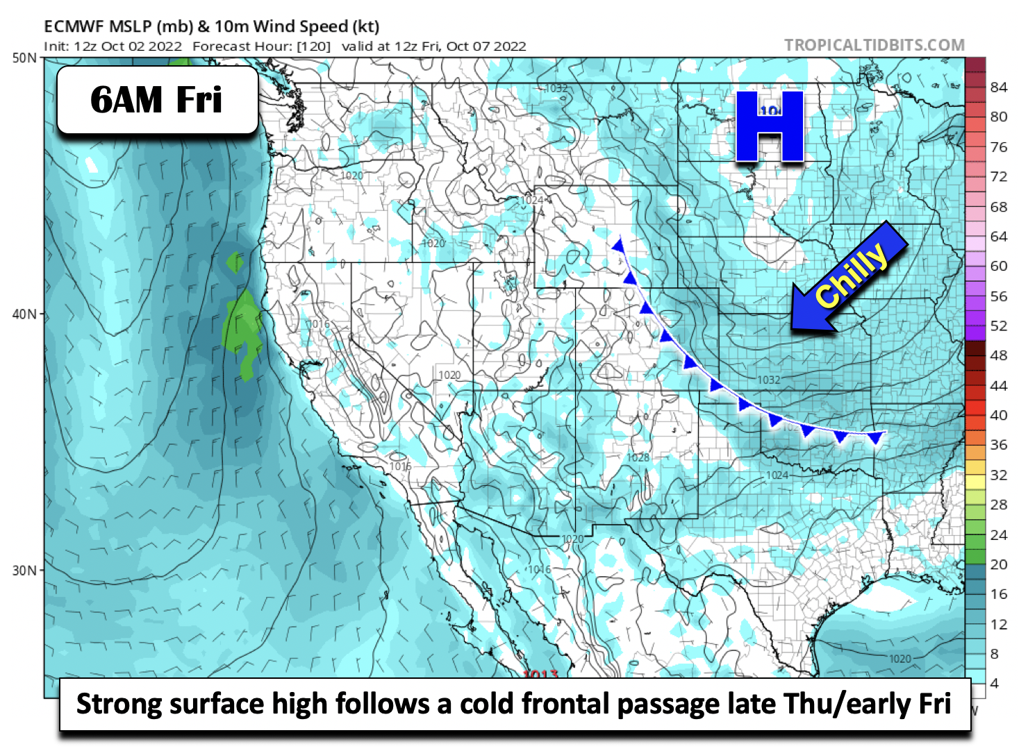
Usually these fronts will usher in low clouds with the moist upslope flow ensuing behind it. Given the strength of the surface high pressure, we think there is a good chance this will happen later this week as well. Additionally, lift from the nearby trough may aid in frontogenetical forcing for some light rain Friday into Saturday along/atop the surface front. As usual, things will could change with this autumnal pattern late-week so do check back for updates.
Finally, today (Monday October 3rd) is the LAST day to enter you prediction to our 2022 First Snowfall Contest. Make sure to get your entry in ASAP.
Forecast Specifics:
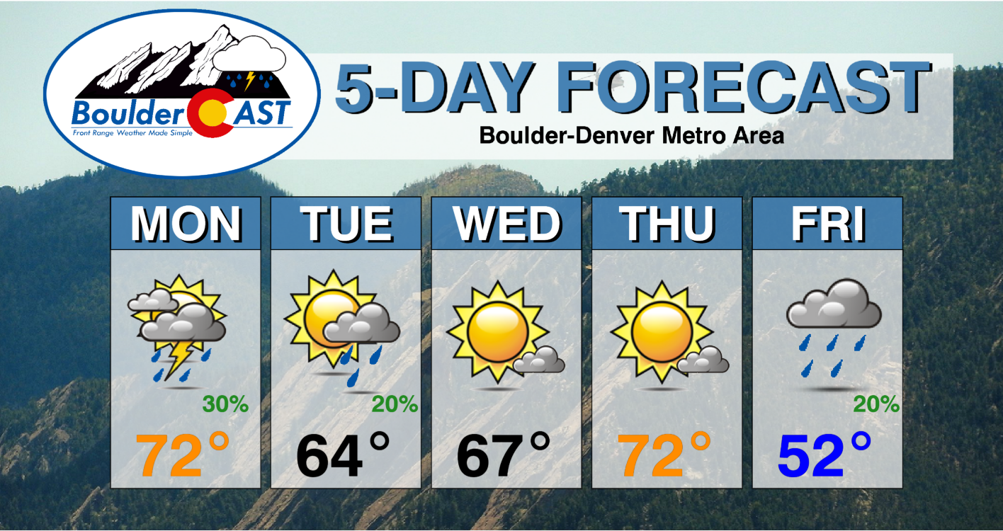
Monday: Clouds and sun with scattered showers in the afternoon/evening. Highs in the upper 60s to lower 70s on the Plains and upper 50s in the Foothills.
Tuesday: Cooler with highs in the low to middle 60s on the Plains and near 50 in the Foothills. Early morning low clouds/drizzle will give way to partly cloudy skies and a slight chance of afternoon showers.
Wednesday: Sunny and warmer with highs in the upper 60s for the Plains and middle 50s in the Foothills.
Thursday: Partly to mostly sunny and warmer with temperatures reaching the lower 70s for the Plains and near 60 in the Foothills.
Friday: Chilly and likely gloomy with highs only in the upper 40s middle 50s for the Plains and lower 40s in the Foothills with overcast skies and a slight chance of drizzle/light rain.
High Country: Rain chances will largely be found Monday (area-wide) and Tuesday (south and west). Some light accumulating snow is possible mainly near and above treeline. Drier weather is forecast Wednesday and Thursday, with a slight chance of late-week showers or high-elevation snow showers Friday into Saturday.
Help support our team of Front Range weather bloggers by joining BoulderCAST Premium. We talk Boulder and Denver weather every single day. Sign up now to get access to our daily forecast discussions each morning, complete six-day skiing and hiking forecasts powered by machine learning, first-class access to all our Colorado-centric high-resolution weather graphics, bonus storm updates and much more! Or not, we just appreciate your readership!
Spread the word, share the BoulderCAST forecast!


You must be logged in to post a comment.