


Category: Forecast (Page 57 of 169)
The week ahead will indeed be an active one across the Front Range as an unsettled pattern remains entrenched across the western United States for the foreseeable future. This will spell out periods of gusty downslope winds, persistently cool temperatures and at least one or two chances for snowfall this week in our area, with the best shot coming Wednesday evening and night.
The sun is out but temperatures are way below zero this Thursday morning! Here’s a few highlights from the ongoing Arctic blast as snow wraps up and a slow warming trend begins across the Front Range.
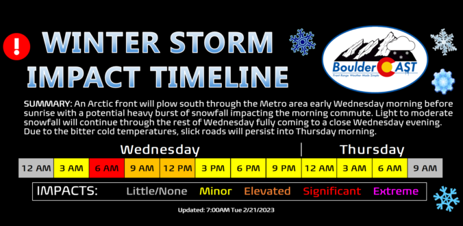
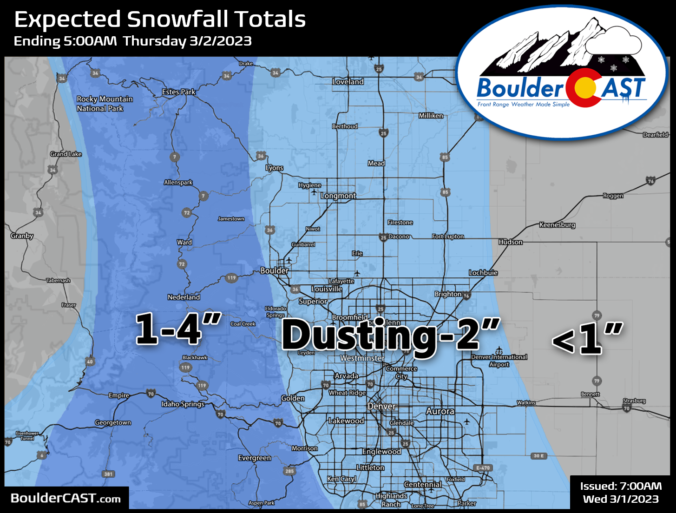
A massive and complex storm is set to slam the entire western United States over the next several days. The Front Range will catch the bitter cold and snowy side of the storm with up to a foot of snowfall possible by Wednesday night alongside record-challenging frigid temperatures. We discuss the latest timing of things, just how cold it will get, the most likely snowfall amounts for the area, and the overall impacts expected from the looming winter storm.
Premium Storm Update (2/21/23 7:00PM): After a beautiful time in the 60s Tuesday, things are starting to look more stormy out there as the sun sets behind darkened clouds. It’s hard to believe, but snow will be falling in less than 12 hours in most areas with temperatures dropping into the single digits and teens in a flash! We run through a final check of the models looking at snow amounts, travel impacts and those cold temperatures. READ HERE
The week starts out mild and at times breezy under a split-flow regime aloft combined with downslope flow at the surface. A deep and highly anomalous trough digs across the western US, Colorado, and Great Plains Wednesday and Thursday, bringing snowfall and record cold for late February. Confidence is increasing for several inches of snow to accompany the cold over portions of the Plains Wednesday, primarily from Boulder northward. The Arctic air slowly retreats by week’s end as a ridge in the southeast US builds westward.
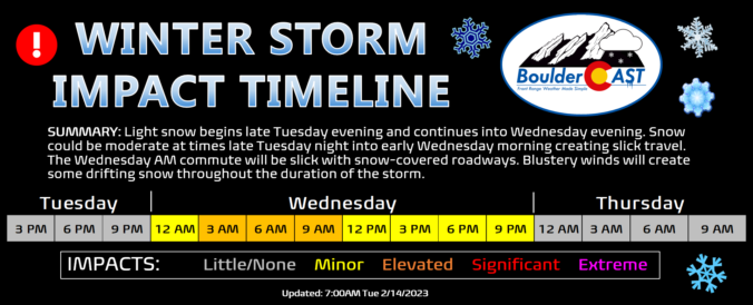
After a nearly two week hiatus in accumulating snowfall, the white stuff returns to the Front Range Tuesday night into Wednesday with a long-duration light snowfall event knocking on the door. Let’s take a look at the latest timing, snowfall amounts, and impacts of the impending winter storm.
Premium Storm Update (2/14/23 3:00PM): Things are coming together nicely with our storm and the snowfall developing late Tuesday evening remains on-track. We run through a final check of the models regarding snow amounts, including a discussion of low and high-end potential for this storm and when it will finally wrap-up on Wednesday! READ HERE
This week will begin and end rather mild, but sandwiched in between will be the return of bitter cold temperatures and widespread snowfall. Though models have trended further south with the midweek snowstorm, everyone should pick up some of the white stuff. Let’s take a look at the roller-coaster of weather set to unfold this week in the Front Range.
There will be two chances of snow to contend with this week, but neither will be much of a concern for us. A few flurries or snow showers are possible on Monday as a weak wave passes through. Later on, a stronger trough approaches with a cold front late Wednesday into Thursday, where colder temperatures in the 30s and gusty winds will be the primary impacts. Current indications of this mid-week system favor the better chance of snow in the High Country, but there could be a brief burst of snowflakes across the lower elevations as well. Read on for more details.

Live View of Boulder

Current Conditions

Live Radar
Latest Smoke Forecast

Recent Premium Posts

BoulderCAST Daily – Wed 07/15/26 | The Ridge Rules the Rockies as Hot, Dry Pattern Holds Firm
🔥 Heat dome setup continues — A strong, stationary 500 mb ridge keeps …
BoulderCAST Daily – Tue 07/14/26 | The Front Range Continues to Bake Under Expansive Ridge
🔥 Heat streak continues — Boulder hit 97°F for the third time in …
BoulderCAST Daily – Sun 07/12/26 | Hot weather for a good chunk of the coming week
🥵 🔥 Heat for a good chunk of the week: Upper 90s through …
3-Day Forecast

Trending Content



© 2026 Front Range Weather, LLC