Sunday’s record-breaking November heat will give way to a dramatic cooldown on Monday, with temperatures plunging 20 to 30 degrees and wave clouds rolling in over the Front Range. The week ahead stays dry and mostly mild, but a few weak cold fronts will stir up some wind and day-to-day temperature swings. And while the forecast looks quiet for now, ensemble models are starting to hint at a colder, potentially snowier shift next week.
Category: Forecast (Page 5 of 164)
After a stretch of crisp, dry days to end the week, our weather is gearing up for a big warm-up this weekend, with near-record highs favored by Sunday. This developing warm and unfortunately dry pattern looks likely to stick around well into November. With each passing day, the odds grow that Boulder might challenge its record for the latest first snowfall.
Bundle up and brace for an eventful week of fall weather across the Front Range as temperatures turn colder! Gusty winds and even a few thundershowers on Monday will precede a frontal boundary set to bring the season’s coldest air yet. Read on for all the details of the week ahead, including a discussion of nightly hard freezes, the Halloween forecast, and a weekend warm-up that might just make you forget it’s the start of November…
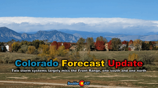
Clouds roll in Thursday as a compact storm system approaches from the southwest—but don’t expect much more than a few sprinkles and high mountain snow. Boulder and Denver stay mostly dry, with mild temps in the 60s and a sunnier stretch ahead for Friday and Saturday. A stronger trough will arrive Sunday into early next week, bringing gusty winds and a taste of cooler fall air, but once again little in the way of meaningful rain or snow east of the Mountains. Read on for all the details.
This week’s forecast is anything but boring in the Front Range. A fast-moving autumn storm is stirring up the atmosphere on Monday with jet-driven Mountain snow, powerful downslope winds, and a fire-weather setup that demands caution. And once the winds die down? A hard freeze will slam the door on the growing season for the entire area Monday night. Read on for a full breakdown of the very active weather unfolding in Colorado on Monday, plus a peek towards the quieter days ahead.
This week will feature a dynamic stretch of autumn weather in the Front Range including dramatic temperature swings, another influx of tropical moisture, and a midweek warm surge that could push us near 80°F. Following all of that, a late-week trough will bring a chilly front and our best shot at rain, plus there’s a weekend wildcard that might even produce some snow. Curious what’s driving all this weather? We break down the atmospheric setup, moisture sources, and ensemble model data in our latest weekly outlook.

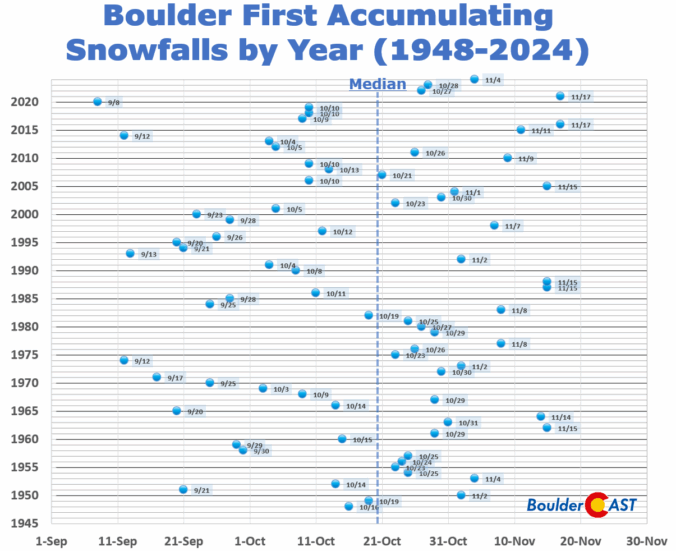
11th Annual BoulderCAST First Snowfall Contest
Ready to toss that first snowball of the season? Maybe you’ve already waxed your skis, shelled out for that pricey Epic Pass, or jumped the gun on snow tires (again). Well, hold onto your mittens—Boulder’s first big snow could be just around the corner, or not! Mother Nature has been playing tricks on us lately. In the past five years alone, we’ve seen both the earliest and latest first snows on record. But, what will 2025 bring? That’s where you come in.
We’re kicking off our annual First Snow Contest! Please take a look at Boulder’s snowfall history within, then submit your best guess for when the first measurable snow (≥0.1″) will fall in Boulder—and how much will accumulate. The closest guesses will win a selection of prizes!
*This contest is now closed to entries*
This week’s weather in the Front Range will be a bit of a rollercoaster. After Sunday night’s soaking rain and snow, Monday kicks off with fog, drizzle, and stubborn clouds before a midweek warm-up brings back the sunshine. But don’t get too cozy: frost season is knocking on the door, and snow signals are starting to flicker in the long-range models. Read on for the full breakdown, including what to expect today, what time rain showers will return later in the day Monday, and when late-season gardeners should start watching for frost and snowflakes.
P.S. Don’t forget to submit your entry to our 2025 First Snow Contest which closes Tuesday night at midnight!

Live View of Boulder

Current Conditions

Live Radar

Recent Premium Posts

BoulderCAST Daily – Tue 02/10/26 | Much cooler for our Tuesday with rain/snow arriving into the Mountains by Wednesday morning
🌡️ After Monday’s 70° warmth, a late‑night cold front has brought an end …
BoulderCAST Daily – Sun 02/08/26 | Mild for Super Bowl Sunday
☀️ Mild through Monday: Highs in the mid 60s to low 70s through …
BoulderCAST Daily – Sat 02/07/26 | A few wave clouds today but still quite mild
☀️ Mild through the weekend: Highs in the mid 60s to low 70s …
3-Day Forecast

Trending Content

© 2026 Front Range Weather, LLC