Hold onto your hats, Colorado—today’s forecast isn’t just another breezy afternoon. A fast‑developing mountain wave event is lining up to deliver some of the strongest winds we’ve seen in quite some time, with Boulder squarely in the bullseye for this event. We’re talking winds that can go from calm to extreme in minutes, near-critical fire danger with every gust, and even the likelihood of planned and unplanned power outages. Add in mountain snow squalls and a sharp cold front tonight, and it’s definitely a busy day in Colorado weather. Read on for the full breakdown of timing, impacts, and what you need to know to stay safe as the event unfolds.
Category: Forecast (Page 3 of 164)
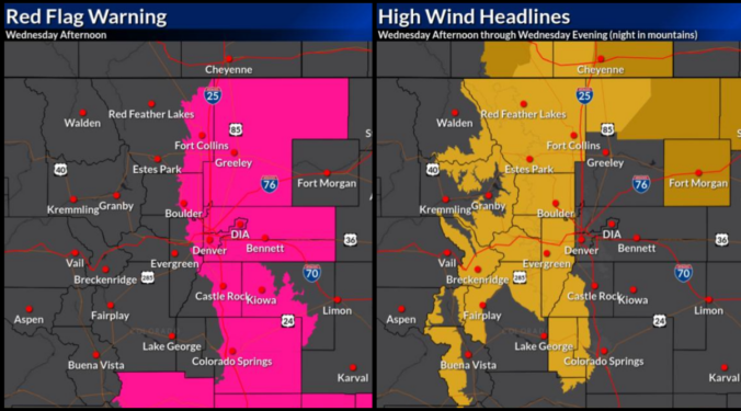
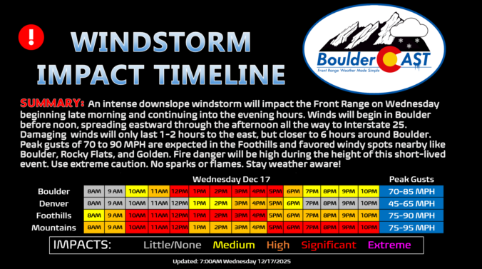
If you thought Monday’s sunshine was the start of a quiet week, think again. The next 48 hours will bring a dramatic shift in our weather —starting with breezy but pleasant conditions Tuesday, then escalating into a powerful downslope windstorm with heightened fire danger on Wednesday. And just when you think it’s wrapping up, a sharp cold front will crash the party with blustery conditions and even a chance for rain and snow Wednesday evening.
We’ll break down what to expect, where the strongest winds will hit, and how this event stacks up against the day of the Marshall Fire. Plus, we’ll look at the potential for Xcel power shutoffs (spoiler: it’s going to be happen).
The Front Range has been defined by relentless warmth, gusty winds, and bone‑dry conditions of late—and that theme isn’t breaking anytime soon. Even with a strong cold front charging through midweek, the cooldown will be pitiful, dropping us only back to “normal” while lasting only a single day, and it comes at the price of near‑critical fire danger beforehand. With highs hovering near or above 60° almost every day leading into Christmas and precipitation chances close to zero, a brown holiday is essentially guaranteed for the Boulder–Denver area. Read on for our full outlook of our weather heading into the holiday period.
The Front Range finally saw its first real snow of the season last week, with Boulder picking up about 8 inches and the Foothills a bit more. The Mountains then cashed in over the weekend, stacking up one to four feet of powder. While this moisture is a welcome boost to our lagging snowpack, it’s not enough to erase drought concerns—but fire risk this year looks very different than the setup before the Marshall Fire. Looking ahead, the story shifts from snow to wind: multiple high‑wind events are on tap for the Foothills this week, while Boulder and Denver stay mostly dry and mild with highs in the 50s to 60s with occasional breeziness. Read on for the full breakdown of this week’s weather.
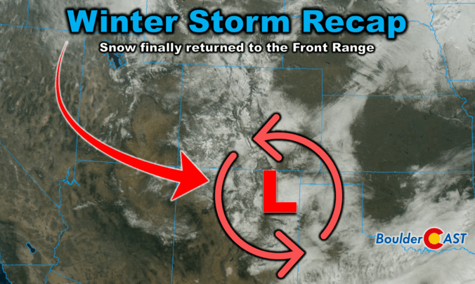
Winter finally showed up in style this week along the Front Range. After a sluggish start to the season, our first true snowstorm delivered nearly 18 hours of steady flakes, painting Boulder, Denver, and much of Colorado in white. But this wasn’t just a simple upslope event—there were some fascinating atmospheric twists that kept the snow machine running longer than expected. We review the storm setup and snowfall totals which greatly favored the western side of the Metro area including Boulder.

Snow has been falling steadily since midnight, turning the Front Range into a real winter wonderland on this Wednesday. We review the regional snowfall totals so far, and discuss the latest forecast details, including when we expect this snowstorm to loosen its grasp on the Front Range.
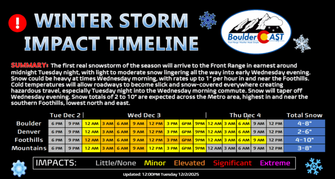
Snow season has finally arrived along the Front Range, and this week’s storm looks ready to deliver more than just a token dusting. After Thanksgiving’s overhyped flurries broke our snow drought, we’re now tracking a midweek system with real staying power—nearly 24 hours of upslope flow, solid moisture, and model agreement pointing to a medium‑impact event. Boulder, Denver, and the Foothills are all in line for several inches, with tricky travel expected Wednesday morning. Curious how much snow your neighborhood could see? We break down the setup, snow totals, and timing…
Winter’s first real punch is on the way… After a quiet start to the week, all eyes turn to Wednesday as a stronger storm system sets its sights on the Front Range. Sunshine today and mild temps Tuesday won’t last long—by midweek, upslope flow and Arctic air will combine to deliver widespread snow and a chilly temperatures to the entire Denver Metro area. How much will fall, and who gets the brunt of it? We break down the latest model guidance, timing, and impacts.

Live View of Boulder

Current Conditions

Live Radar

Recent Premium Posts

BoulderCAST Daily – Tue 02/10/26 | Much cooler for our Tuesday with rain/snow arriving into the Mountains by Wednesday morning
🌡️ After Monday’s 70° warmth, a late‑night cold front has brought an end …
BoulderCAST Daily – Sun 02/08/26 | Mild for Super Bowl Sunday
☀️ Mild through Monday: Highs in the mid 60s to low 70s through …
BoulderCAST Daily – Sat 02/07/26 | A few wave clouds today but still quite mild
☀️ Mild through the weekend: Highs in the mid 60s to low 70s …
3-Day Forecast

Trending Content

© 2026 Front Range Weather, LLC