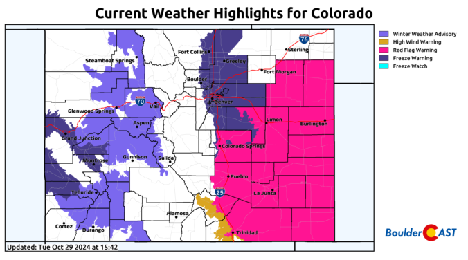
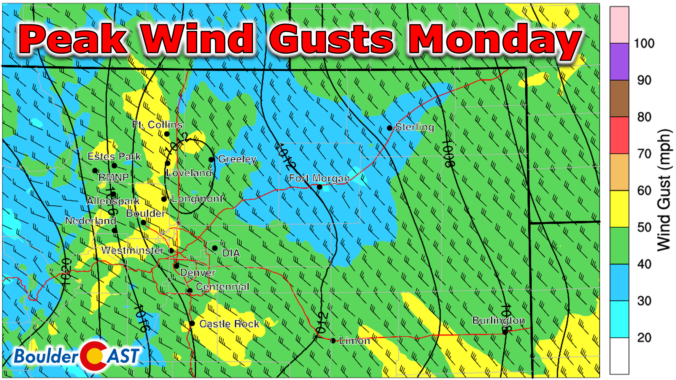
The second week of September will bring a prolonged period of unseasonable warmth to the Front Range along with minimal rainfall. The early to mid-week period will actually have slight chances for rain, but late-week will have much drier air and gusty winds leading to elevated fire danger. Temperatures will remain close to 90 degrees every single day in the extended, with some influx of wildfire smoke at times from the Pacific Northwest. Read on for all the details.
August brought welcomed change to the Front Range with the elusive American Southwest Monsoon finally making a late appearance. While much of the area ended with below normal rainfall in August, it was notably wetter than months prior leading to a slight improvement in the regional drought. It was also hot in August, with overall temperatures and the number of 90-degree days landing above normal. Here’s a quick and colorful graphical recap of our weather during August and how it relates to climatology.
September is finally upon us — what a great time of the year this is in Colorado! Mother Nature will deliver rather varied weather this week in the Front Range. Hot temperatures and high pressure will give way to a Pacific trough by midweek. Clouds will be on the increase alongside the risk of severe thunderstorms for Wednesday, with even a touch of snow in our highest elevations. Things will clear out nicely for the upcoming weekend leading to gorgeous and seasonal late-summer conditions. Read on for all the details.
After three months with barely any rainfall, our parched vegetation unfortunately ignited at the end of July with several large wildfires taking off in the Front Range burning more than 12,000 acres combined. Unsurprisingly, drought further expanded in July and numerous jurisdictions enacting fire bans. Overall temperatures during the month were close to normal following several periods of ups and downs. Here’s a quick and colorful graphical recap of our weather during July and how it relates to climatology.
Our scorching hot, two-week-long heatwave will finally come to an end later this week, but not before we endure a few more days. A cold front is slated to arrive into the Denver area late Wednesday finally knocking us out of the 90s. This front will also come with an enhanced chance of rainfall, though monsoon moisture is still largely lacking. Despite daily chances for rain this week, our existing fires will continue to smolder and the risk of new fire ignitions remains uncomfortably high.
Between the extreme heat, thick smoke and new wildfire ignitions, this week has been quite the disaster in the Front Range! Our fuels have been primed for weeks now and our team has been vocal regarding this inevitable outcome, but things unravelled much quicker than even we expected this week with something like ten wildland fires in the Front Range just since Monday, in total burning more than 9,000 acres of forest! The weekend unfortunately won’t offer much reprieve from the heat, fire or drought, but we are tracking a potential shift next week towards wetter and cooler conditions. We provide an update on the local fires, the ongoing heatwave, the widespread smoke, and when actual raindrops may return to the forecast.
© 2025 Front Range Weather, LLC