The weather week ahead in Colorado will initially be focused on a series of weak shortwaves tracking from west to east across the state. A more potent trough will develop later in the week but uncertainty lies in its overall track and moisture availability this far out. Together these systems will lead to low-end chances of showers and storms each day this week, although most of us will see more dry time than not. As for temperatures, they will mostly hover a few degrees above normal in the lower 80s each day — a fitting end to the summer season which wraps up on Friday!
This week’s highlights include:
- Temperatures this week hover around or slightly above normal close to 80 degrees
- A series of weak shortwave disturbances will offer low-end rain chances Monday and Tuesday
- A more potent system could bring rain Thursday or Friday, but uncertainty lies in its track and the moisture availability
- Gusty winds will follow a cold front late Friday with elevated fire danger and then a potential downslope wind event Friday night
- The upcoming weekend will be notably cooler but likely sunny, a fitting first few days of autumn
DISCLAIMER: This weekly outlook forecast is created Monday morning and covers the entire upcoming week. Accuracy will decrease as the week progresses as this post is NOT updated. To receive daily updated forecasts from our team, among many other perks, subscribe to BoulderCAST Premium.

Go Premium, get all the perks.
Daily Forecast Updates
Get our daily forecast discussion every morning delivered to your inbox.
All Our Model Data
Access to all our Colorado-centric high-resolution weather model graphics. Seriously — every one!
Ski & Hiking Forecasts
6-day forecasts for all the Colorado ski resorts, plus more than 120 hiking trails, including every 14er.
Smoke Forecasts
Wildfire smoke concentration predictions up to 72 hours into the future.
Exclusive Content
Weekend outlooks every Thursday, bonus storm updates, historical data and much more!
No Advertisements
Enjoy ad-free viewing on the entire site.
A few disturbances warrant low-end shower chances to start
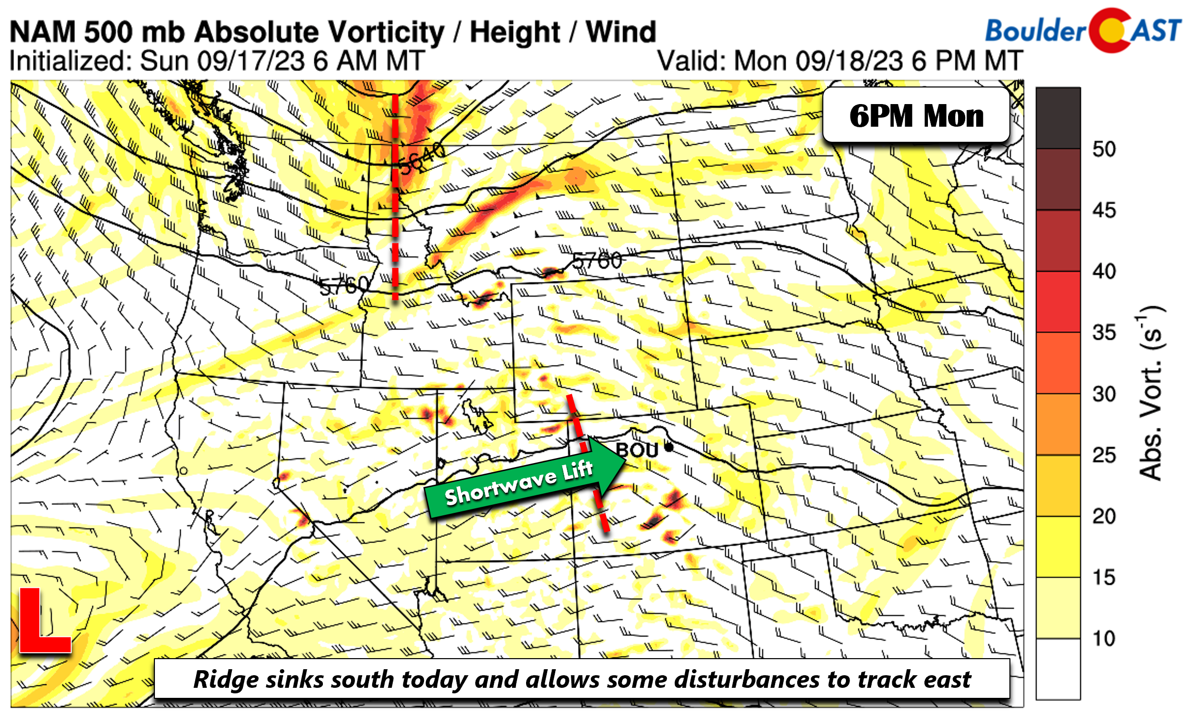
The first few days of the week will entertain a few shortwave disturbances tracking from west to east across the northern Rockies. The ridge from the weekend will slide to our south and allow a somewhat more moist zonal flow to ensue. Embedded in that flow will be some shortwave energy passing through Colorado both Monday (shown below) and Tuesday.
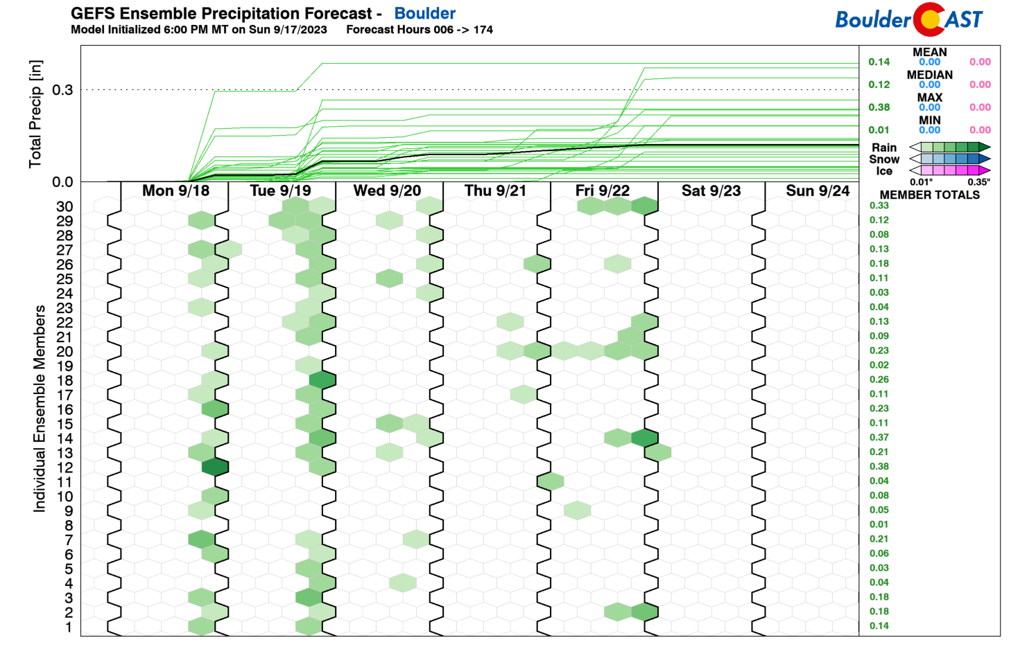
The GEFS precipitation outlook for the week shows us the chances of showers or storms Monday and Tuesday which are tied directly to the run-of-the-mill shortwaves in the zonal flow. We also see continued but lesser chances of rain the rest of the week — we’ll discuss that in a moment!
The figure below shows the energy tracking east for Tuesday afternoon and evening. You’ll notice very little change from Monday, although a trough over Montana and Idaho will aid in providing a tad more lift across the Front Range. As such, our rain chances should be higher Tuesday relative to Monday.
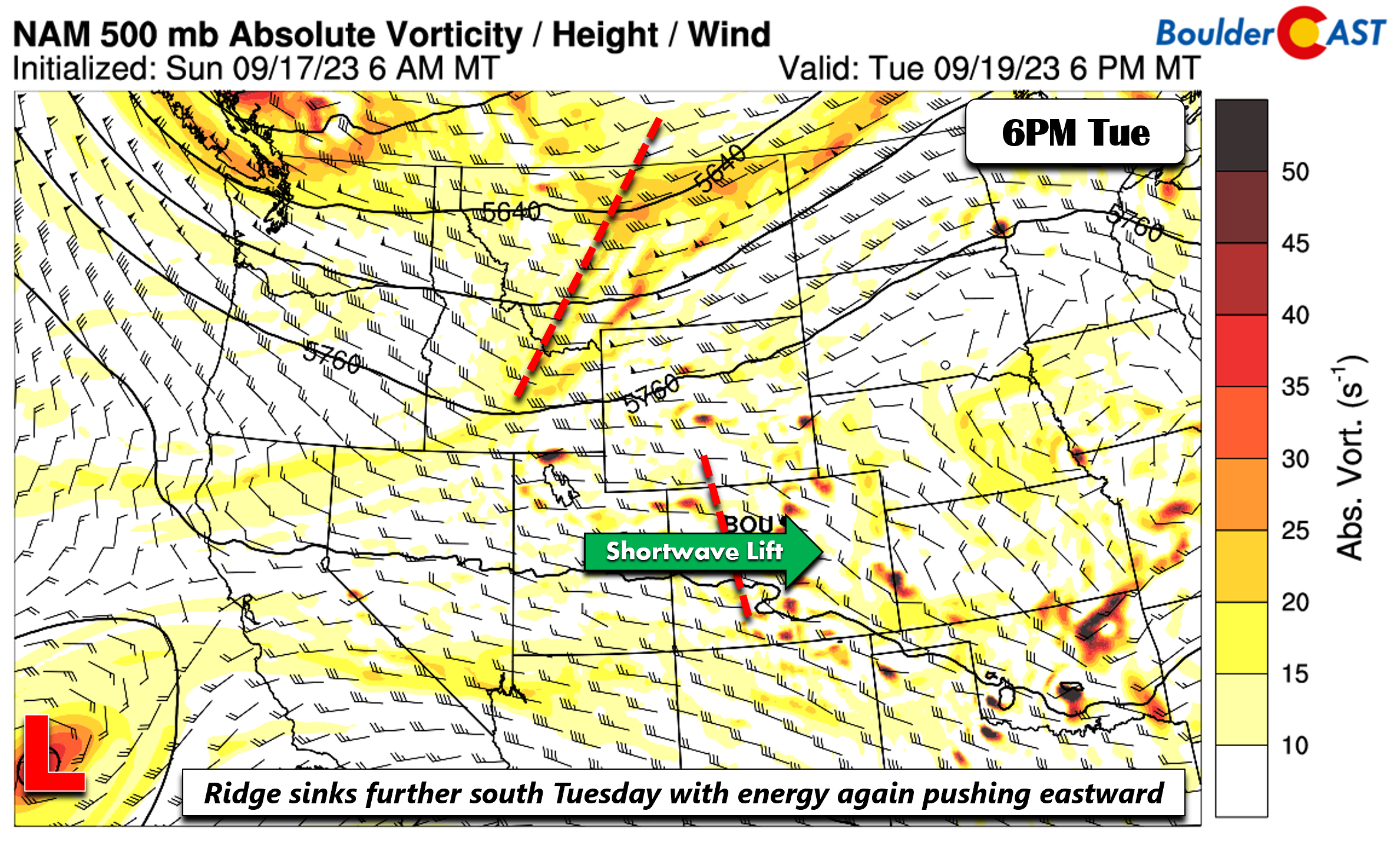
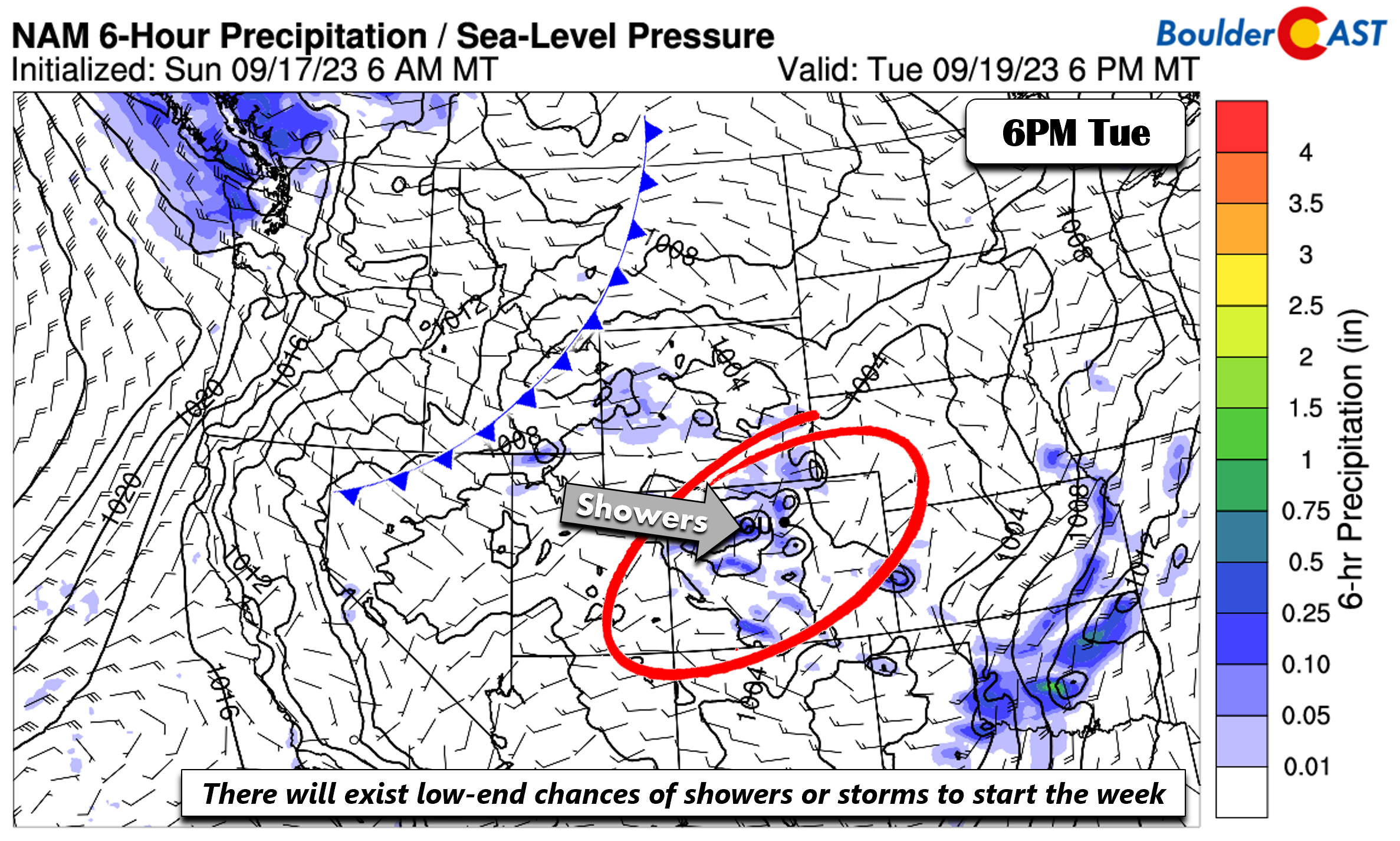
The NAM precipitation forecast on Tuesday shows the shower activity first developing across the higher terrain and then reaching the Plains later in the day into the evening. Overall, rain chances early in the week will be on the low-end of the spectrum, only around 10 to 30%. Any potential storms are not expected to be severe given weak shear and low instability across the Plains.
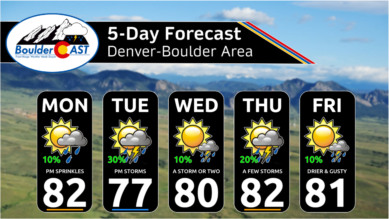
Temperatures Monday and Tuesday, and in fact, most of the week, will hover around 80 degrees. A lee trough will largely exist most of the week, favoring an overall downslope flow pattern east of the Mountains. This is one reason why our rain chances will be low to start the week as this will promote sinking and drying air.

More active late in the week — but uncertain on rain chances
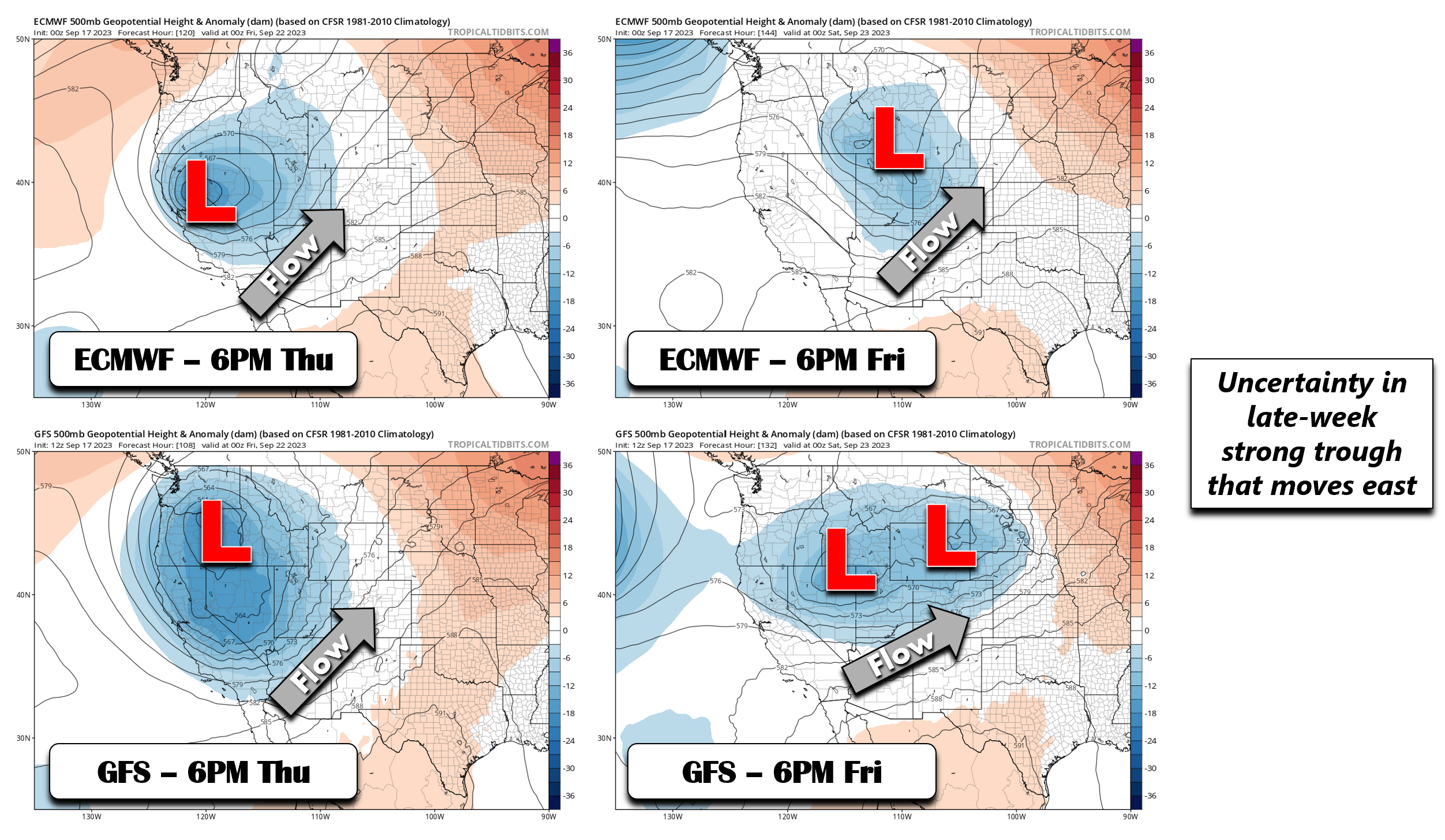
As we head into the middle to latter part of the week, the ridge will inch northward on Wednesday. As that happens, disturbances will get shunted a tad to our north and should keep us largely dry for midweek. However by late in the week, the ECMWF, GFS and other modeling guidance are showing a deep trough that will track eastward Thursday into Saturday. As usual, the ECMWF and GFS are not in agreement on its location, timing, and strength at this point. The ECMWF shows a deep trough over northern California Thursday that reaches western Wyoming Friday. The GFS shows a more elongated trough Thursday, centered over eastern Oregon, tracking it east into eastern Wyoming later Friday.
The one similarity between the models this far out is that a strong cold front will likely push through sometime Friday or Friday night (see below). Before that happens, models show a deeper fetch of moisture surging up from Mexico on Thursday. By Friday, most guidance has the atmosphere drying out as the cold front slides east. This frontal passage may combine with a tighter height gradient to promote dry and gusty winds Friday afternoon or night, which could favor increased fire danger over the state. Some signs also point to a mountain wave developing for strong downslope winds behind this front.
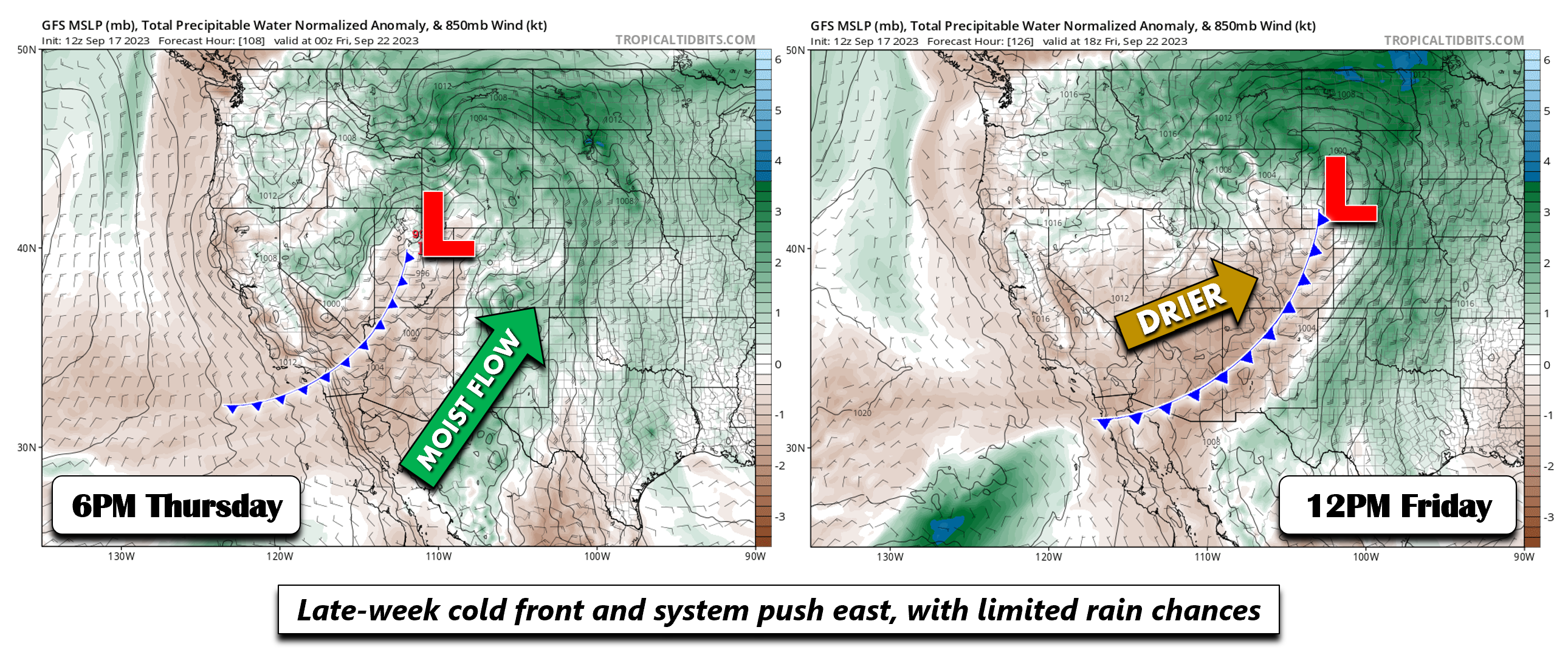
As for precipitation chances, confidence is not very high on when and if we will see measurable rainfall. For one, a broad downslope flow at the surface may limit shower coverage with this system. Secondly, the current track would favor areas east and north of Colorado. As it stands, it would appear Thursday would be our best chance for late-week showers, albeit still on the low-end at around 20%.
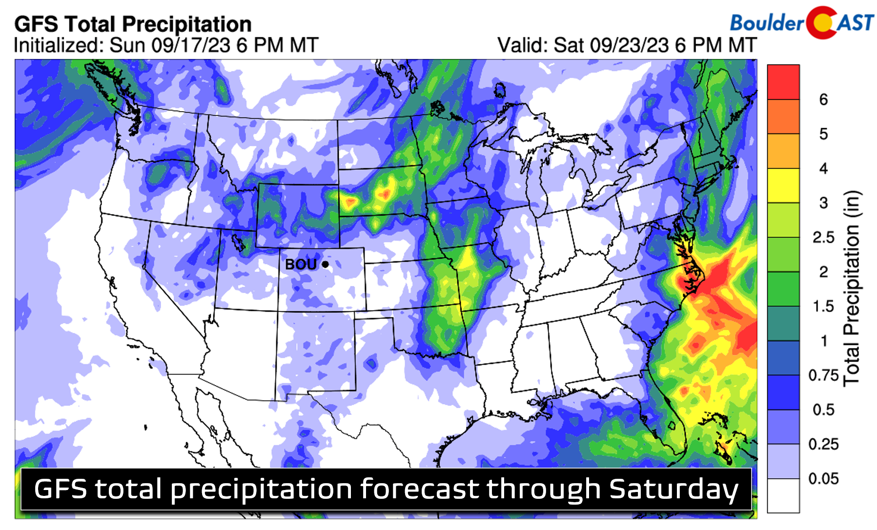
While we remain hopeful that most of our area will see at least one bout of rain this week, we’re not overly optimistic. Even the wettest days won’t impact everyone. With that in mind, enjoy the continued warm weather in the days ahead — extended stretches in the 80s like this are certainly running on borrowed time! The first day of autumn is Saturday after all…
The upcoming weekend should be somewhat cooler than normal behind the aforementioned cold front. Look for highs to “fall” back into the lower 70s for the weekend with sunshine looking increasingly widespread. Enjoy!
Forecast Specifics:
Monday: Partly sunny skies giving way to increasing clouds and a 10% chance of a sprinkle or light t-shower. Highs in the lower to mid 80s for the Plains and lower 70s in the Foothills.
Tuesday: Partly cloudy with a 20-30% chance of showers and storms with highs in the upper 70s for the Plains and upper 60s for the Foothills.
Wednesday: Mostly sunny and largely dry with highs in the lower 80s for the Plains and lower 70s in the Foothills. A stray shower or two may for in the late-day period with little consequence.
Thursday: Partly cloudy with a 20% chance of showers or storms. Highs in the lower to mid 80s on the Plains and lower 70s in the Foothills.
Friday: Mostly sunny, gusty and mild with a 10% chance of showers. Highs near 80 on the Plains and upper 60s in the Foothills. A downslope wind event may unfold Friday evening or night.
Weekend: Dry behind a departing storm system, but cooler. Look for highs in the lower 70s both Saturday and Sunday with likely mostly sunny skies.
DISCLAIMER: This weekly outlook forecast is created Monday morning and covers the entire upcoming week. Accuracy will decrease as the week progresses as this post is NOT updated. To receive daily updated forecasts from our team, among many other perks, subscribe to BoulderCAST Premium.
Go Premium, get all the perks.
Daily Forecast Updates
Get our daily forecast discussion every morning delivered to your inbox.
All Our Model Data
Access to all our Colorado-centric high-resolution weather model graphics. Seriously — every one!
Ski & Hiking Forecasts
6-day forecasts for all the Colorado ski resorts, plus more than 120 hiking trails, including every 14er.
Smoke Forecasts
Wildfire smoke concentration predictions up to 72 hours into the future.
Exclusive Content
Weekend outlooks every Thursday, bonus storm updates, historical data and much more!
No Advertisements
Enjoy ad-free viewing on the entire site.
Get BoulderCAST updates delivered to your inbox:
Enjoy our content? Give it a share!


You must be logged in to post a comment.