Happy President’s Day! A winter storm is impacting northern Colorado with snow and much colder temperatures today through Wednesday. Models are latching onto a track the will produce a sharp gradient in snow amounts across the Denver Metro area. Read on for our full forecast.
Update (7:00 PM Monday evening): Heavy snow has been falling intermittently across the northwestern Metro area for the last few hours, especially from Boulder northeastward into Longmont along a stationary jet-forced snow band (shown below). Snow totals of 4 to 8″ have been reported thus far in these areas. Snow intensity should be diminishing over the next few hours as the jet moves east. 1 to 4″ of additional accumulation can be expected if this band moves over your area this evening (mostly north of Interstate 70).

OVERVIEW
When we first alerted you to this storm on Friday, our main concern was that the track was too far north, keeping most of the energy across Wyoming. While this does remain an issue to some degree, the models have inched things southward over the last few days. Winter weather will indeed be impacting the Front Range for an extended period beginning late last night with freezing fog and drizzle, and continuing with snow into Tuesday.
The atmospheric ingredients coming together over Colorado are not that great with this system, something we are all surely accustomed to by now. However, the best aspect of this storm will be its slow progression. The 500 mb vorticity maps below for Monday afternoon (left) and Tuesday afternoon (right) show the storm barely making any eastward progress. We will remain in a marginally favorable location for snow beginning this morning and continuing into Tuesday night, a near 48-hour window for winter.
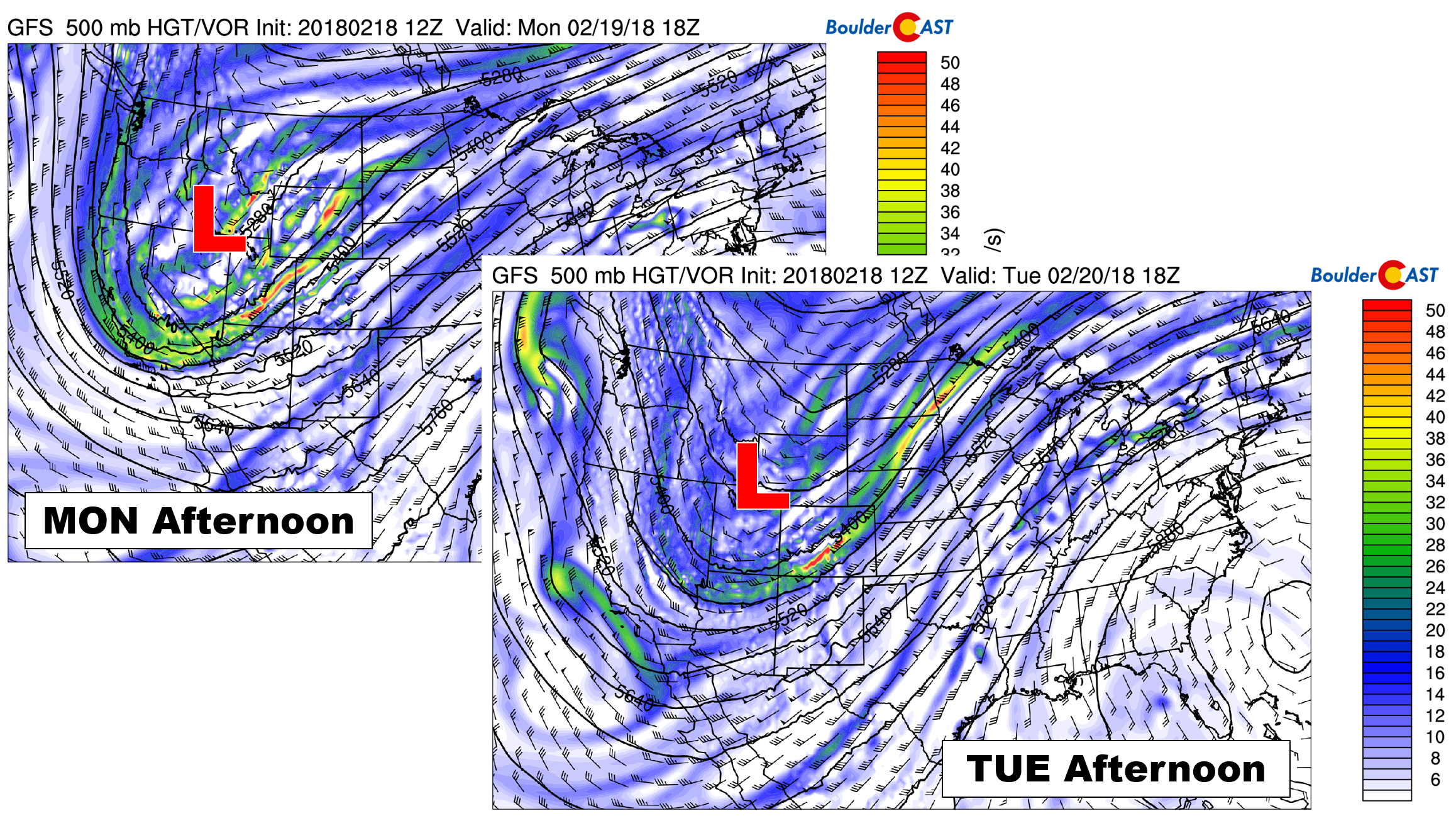
GFS 500 mb vorticity maps for Monday afternoon (left) and Tuesday afternoon (right) show the storm’s slow movement.
Forcing for snow will actually come in three separate waves. Whether snow fully ceases between each remains to be seen, but it is not likely. This is especially true in and near the base of the Foothills where light upslope will continue from now through Tuesday night…
1) Weak frontal forcing Monday morning brings light snow, freezing drizzle
Overnight, there was a four to six hour period of light freezing mist or drizzle across the area. Overlapping with midnight, Denver officially added two more counts of freezing drizzle, bringing the 2017-18 winter total to 11 calendar days. This is more occurrences than the prior six years combined.
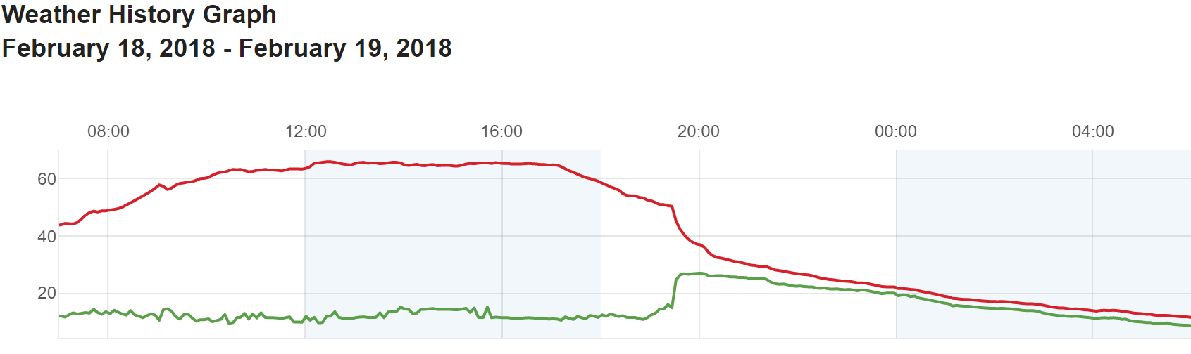
After highs in the 60’s yesterday, the graph below of temperature at BoulderCAST Station (red line) shows the cold frontal passage around 8:00 PM Sunday evening. As of 7:00 AM Monday, we are reporting a chilly 11 degrees.
At least here in Boulder at 5600 feet elevation, everything was initially glazed in ice around 3:00 AM. Things have since turned over to snow, with fluffy accumulations nearing 1″ already. We expect the shallow upslope flow to keep light snow going intermittently through the day near Boulder. Additional accumulations before 3:00 PM will be less than 2″ in most cases. East and south of Denver, things will probably quiet down for much of the day as southeasterly flow downslopes from the Palmer Divide, until #2 arrives….
2) Jet-forced snow Monday afternoon and evening
While upslope will generally be light and moisture not all that exceptional, a passing jet streak this afternoon and evening should add fuel to the fire, spawning several jet-forced heavy snow bands across the Metro area. The 250 mb wind forecast for this evening shows that northern Colorado will be in the right entrance of the jet.
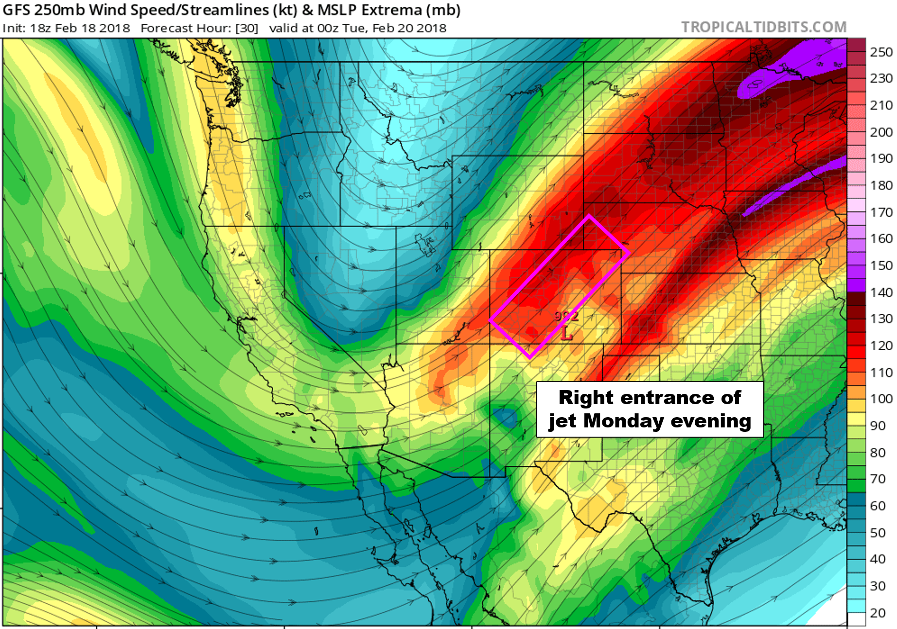
GFS 250 mb wind forecast for Monday evening showing the favorable position of the jet.
Snow bands will be oriented southwest to northeast, and due to the position of the jet, will mostly favor the northwestern Metro area. We’re talking from Broomfield to Boulder, northward towards Fort Collins. With favorable dendritic snow growth aloft, snowfall rates will near 2″ per hour in these bands. Look for the jet banding to begin later this afternoon and continue through the evening. The jet will move eastward by midnight, bringing an end to this threat of banded snow.
The Denver Metro area will likely be split in half for snow today as that is the current trend agreed upon by the GFS, Euro, and HRRR models. The core of the heavier snow is expected to remain north and west of Broomfield. The line of demarcation between a small amount of snow and many inches could be sharp this evening.

GFS modeled snowfall forecast for the entire event. The heaviest core of snow will situate north of Denver in a line from Boulder to Greeley.
The HRRR model reflectivity for 6:00 PM Monday evening lines up with the placement of the bands from the GFS:

HRRR simulated reflectivity for Monday evening showing heavy jet-forced snow band
And the NAM model:

Overall, we’re seeing very good agreement in the models for a feature that typically has limited predictability. We think that 3 to 6″ of jet snowfall Monday evening is a safe bet for Boulder, Longmont, and Estes Park. We’re actually even concerned that totals in a narrow band somewhere near Boulder or Broomfield could be higher than this due to the stationary nature of the banding. In fact, the latest run of the HRRR produces a swath of 10-12″ of snow near Broomfield this evening.
3) Lighter upslope snow Monday night into Tuesday morning
Just as the jet moves eastward, a secondary push of upslope will enter into the region tonight before midnight. The NAM meteogram below shows this deeper and stronger upslope push (boxed in purple). The upslope reaches a depth of around 725 mb. Not great, but good enough to enhance snowfall across Boulder and most of the lower to middle Foothills.

NAM model time-height plot of winter speed and direction. Highlighted in purple is a reinforcing push of upslope Monday night.
This secondary push of upslope should produce another 1 to 3″ for the western Metro area and Foothills by Tuesday afternoon.
Snow totals
Summing everything up, our snowfall forecast map is shown below. Keep in mind this snow will be falling across an extended period…one which has already begun but will continue into Tuesday afternoon. The best chances for moderate to heavy snow will be late Monday afternoon until midnight Monday night. With the “X-Factor” of jet-forced snow, it’s hard to say for sure the precise locations where these bands will land Monday evening. The few places that get hit hardest may top 10 or 12″ tonight.

And no, Longmont…there was NOT a mistake with our snowfall map. You actually have a decent chance at seeing more than 3″ of snow for once!
Eastern Boulder County should see advisory criteria for snow met this evening. We expect the NWS to at least tack on Boulder to the existing Winter Weather Advisory later this morning. The advisory currently only covers the higher elevations and Fort Collins.

The COLD lingers
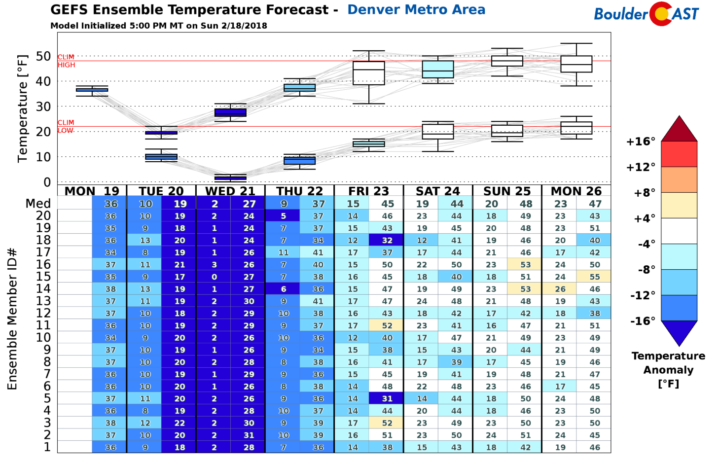
The cold air will make for snow-packed road conditions, especially during Monday evening’s rush hour into Tuesday morning. Highs Monday and Tuesday will only be in the TEENS. Temperatures Wednesday morning will be close to zero across the Plains, and below zero in the Foothills and Mountains. The ensemble temperature forecast shows the cold air lingering through much of the upcoming week. More on this extended cool-down in our weekly outlook tomorrow…
Let it snow!
Share our forecast:
.


You must be logged in to post a comment.