
Our forecast for the holiday weekend covers two separate wind storms, very warm weather across the Plains, and President’s Day snowfall.
Yesterday’s upper-level distrubance brought impressive convective precipitation to the Metro area. The cumulus cloud structure was stunning for the middle of February. There were even a few lightning strikes with this system across western Colorado and Utah, a sign that spring isn’t all that far away. Take that Phil!

Lightning strikes that occurred Wednesday into Thursday showing a few flashes across Utah and western Colorado.
Parts of southern Denver recorded 1 to 2″ of snow from the convective bands of precipitation Thursday evening. The northern Metro area, including Boulder, saw a few flakes up to 1/2″ of snow. This was in-line with our Premium forecast from yesterday morning.
High pressure is now in control across Colorado and the entire central United States. For the rest of Friday, expect sunny skies with temperatures pushing to near 40 degrees.
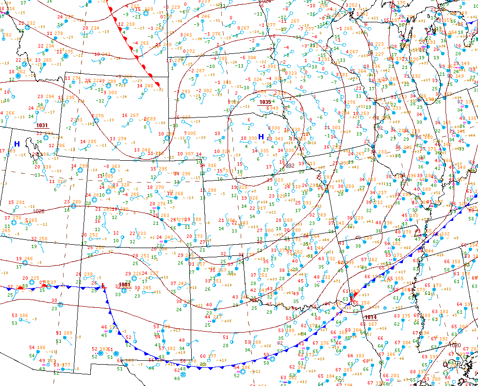
Surface map for Friday morning. High pressure is centered over Nebraska. Yesterday’s cold front is moving through Texas this morning.
Windstorm2
The main weather focus over the weekend will be the potential for two separate high wind events across the Mountains and Foothills.
A jet streak will be passing just to our north throughout Friday night. This will put northern Colorado in the right-exit region, an area favored for subsidence. This combined with a warm (stable) layer near the peaks of the Continental Divide will help cascade strong winds down across the lee slopes of the Mountains and the Foothills tonight.

3KM NAM forecast sounding over Boulder for 5AM Saturday morning. The stable layer aloft is highlighted. This layer is approximately 10,000 to 15,000 feet elevation.
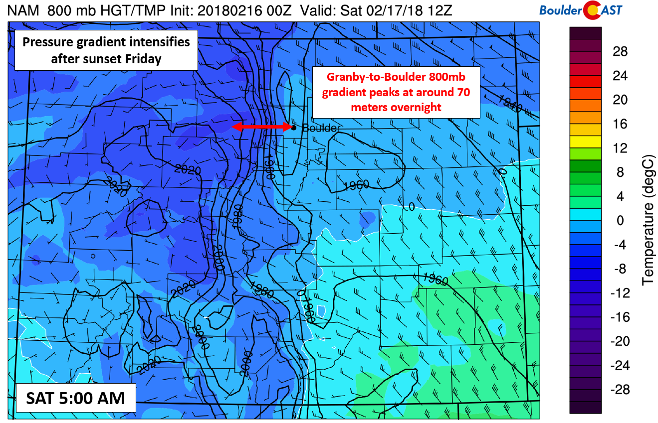
The NAM 800 mb temperature and wind map below shows the Granby-Boulder height gradient at 5:00 AM Saturday will be nearing 70 meters. Everything we are seeing in the models indicates gusts of 55 to 70 mph will be possible in the Foothills from around midnight Friday night into Saturday morning. It doesn’t appear Boulder will get in on the action much, though some brief gusts of 30 to 40 mph seem at least plausible during this time.
After winds die down slightly during the day Saturday, another potentially stronger round will develop Saturday night. The timeline of 800 mb Granby-Boulder height gradient is shown below. Notice the first event peaks Saturday in the early morning, and the second redevelops Saturday night into Sunday morning.

While the Saturday night event is forecast to have stronger gradients overall, the other components will NOT be as favorable to bring these winds down in elevation. Model uncertainty is still somewhat high for this second event, however. Winds near and just east of the Divide could gust to 75+ mph. Further down into the Foothills, winds look less intense than Friday night. The blade separating extreme wind and basically nothing is a fine one with downslope wind storms. This will be the case Saturday night. For now, we expect the secondary wind storm to be confined mainly above 10,000 feet where little if anyone actually lives. The tundra may experience near blizzard conditions due to recent fresh snow through the weekend. Keep that in mind if you’re heading to the High Country to ski or snowshoe. Plan ahead for cold and blustery weather!
The warm before the storm
On the bright side, the lower elevations will be the beneficiary of downslope warmth from the wind events in the higher elevations this weekend. Temperatures Saturday will be in the 50’s, with 60’s on Sunday. Higher-resolution models are even showing temperatures nearing 70 degrees on Sunday. Not quite record warmth, but it sure will feel like spring! Sunny skies will prevail both days this weekend (outside of a few wave clouds Sunday morning).
Another snowy federal holiday
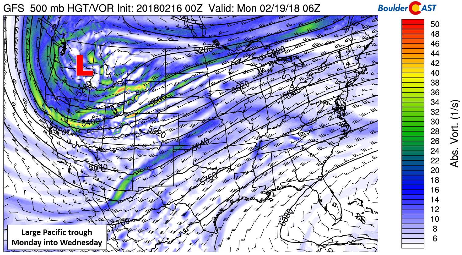
By end-of-day Sunday, a Pacific storm system will be entering the picture. The 500 mb vorticity map below shows the position of the system Sunday night. It has quite the breadth….the largest we have seen in many weeks for Colorado.
This trough will bring a potent cold front into northeast Colorado on Monday. The timing varies slightly across the models from the morning hours through the afternoon. Behind this front, much colder air and upslope will filter into the Front Range.
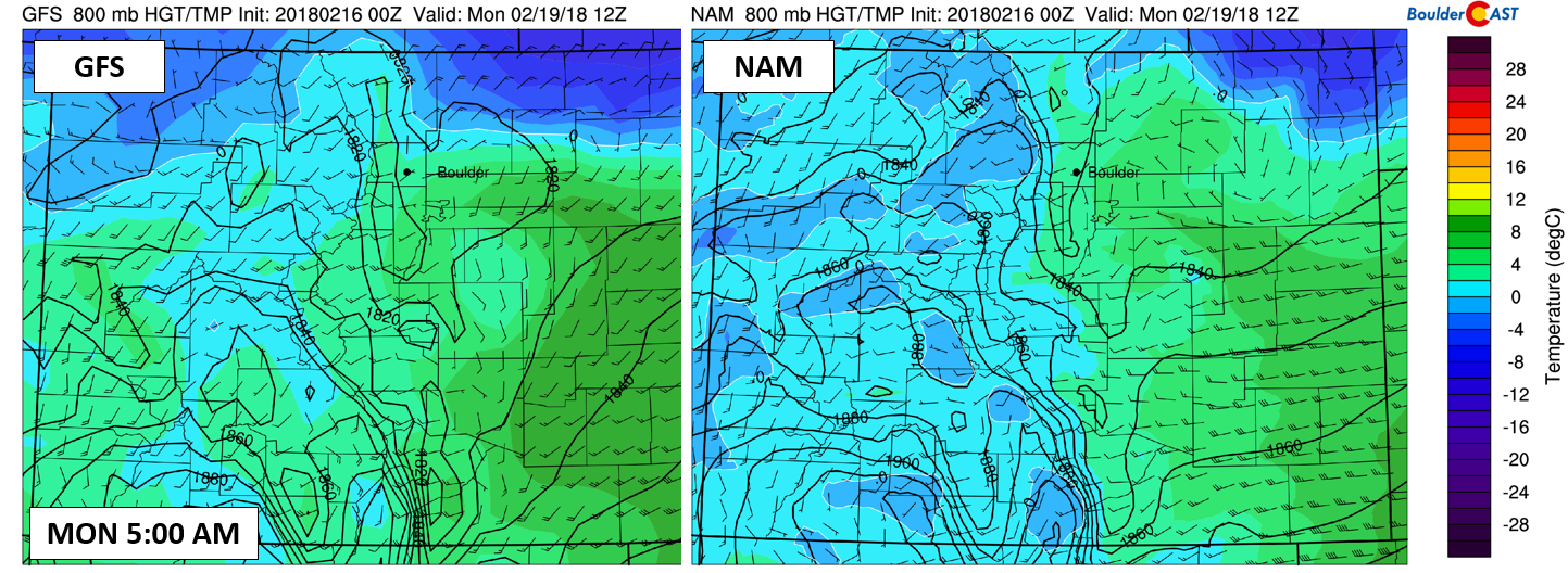
800 mb temperature and wind forecast for Monday morning at 5:00 AM from the GFS (left) and NAM (right) showing the cold front entering northeast Colorado. The exact timing of the front on Monday is uncertain now.
Temperatures will tumble significantly for first half of the week from where they will be this weekend. A recent addition to our suite of Premium Ensembles are 8-day temperature forecasts. You can see the dramatic shift in temperatures early next week. Highs Monday will probably be in the 30’s. Tuesday we’ll be stuck in the 20’s if things go as planned.

The best large-scale forcing from the Pacific trough is currently forecast to remain north of our area, from Fort Collins into central Wyoming. However, there is time for things to change and become snowier for us. One favorable aspect for this storm is its large scale and relatively slow movement. This alone should at least keep the upslope and chances for snow in our forecast from Monday morning into Tuesday afternoon or evening. The duration of this upcoming event looks to be much longer than the quick-movers of late. The precipitation ensemble forecast below from the GFS shows the extended chance of snow nicely.
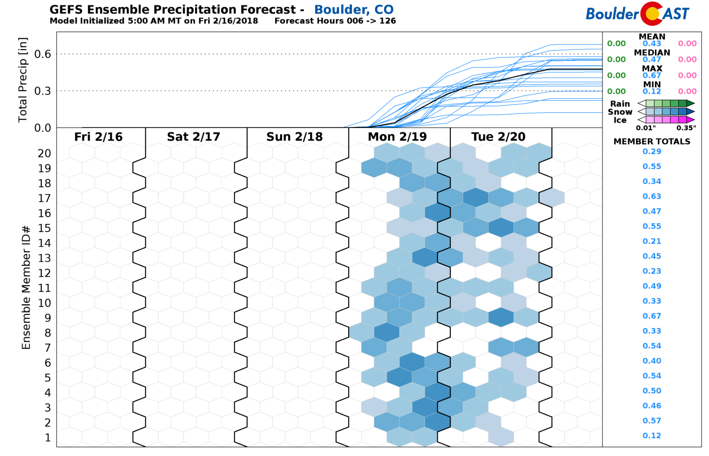
Snowfall amounts are uncertain at this time, but plan for wintry weather the second half of Monday and the first half of Tuesday. The Metro area will likely be socked in with cold air and clouds on Tuesday. The Euro model has highs only in the teens! Not an official forecast by any means, but as it stands now, the latest run of the GFS model produces 4 to 8″ of snow for us from the storm, with more than a foot up near Fort Collins and in the Foothills of Larimer Country. This storm synoptically has a great look to me. However, the finer details will need to be ironed out in the coming days. We’ll keep you updated through the weekend as things develop. Join BoulderCAST Premium for daily updates this weekend, and every day, in fact!
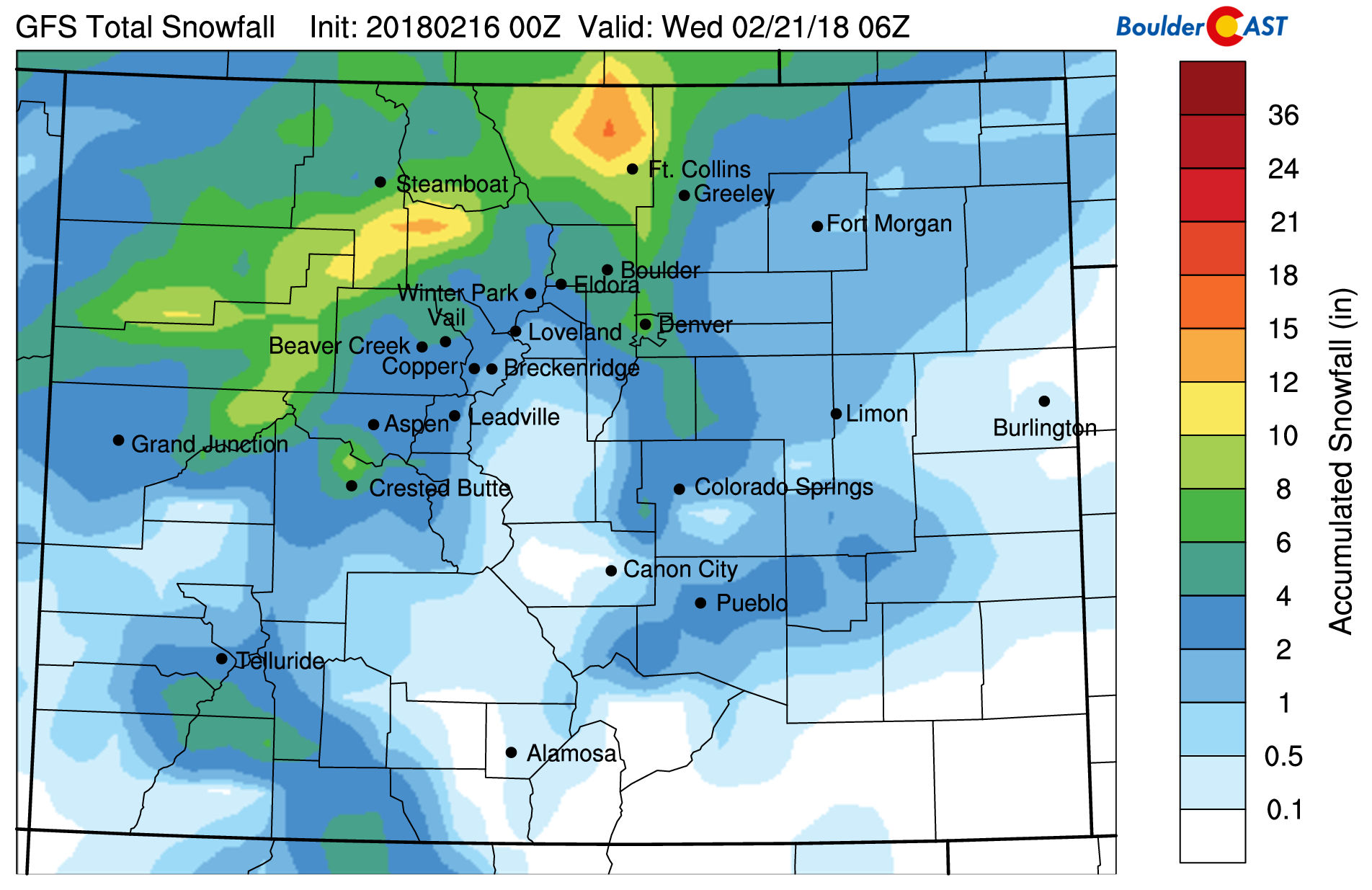
GFS model-derived snowfall forecast for snow Monday into Tuesday. This is only one model’s forecast for the event (four days lead time as well).
Help spread accurate weather knowledge…share this post:
.


You must be logged in to post a comment.