Despite substantial uncertainty earlier in the week, a potent winter storm is taking aim on Eastern Colorado for Thursday and Friday! Just about everyone will see some of the white stuff, with some areas likely measuring their accumulation in feet by Friday evening. How much snow will you get? Read on to find out.
.
It is a classic April snow storm for the Front Range. The mountains will rack up 1 to 3 feet of snow, which is much needed to avoid drought and to enhance the currently-lacking snow-pack. So, if you have any skiing left in you, this weekend might be the best for powder! However, with this storm, the devil is in the details for lower elevations, but we will try to discuss the main factors at play for this event, focusing on the three vital ingredients necessary for any precipitation event: moisture, instability, and lift. Models have come into general agreement, including the NAM (North American Mesoscale), GFS (Global Forecast System), ECMWF (European Centre for Medium Range Weather Forecasts), and WRF (Weather Research and Forecasting) models.
1. Synoptic Weather Situation
The map below shows the 500 mb pressure level map of vorticity (shaded) and geopotential heights (contoured) for the current time (Wednesday morning at 15Z) from the GFS. This is courtesy of College of DuPage weather. As you can see, the upper level low pressure system is currently to our west across Utah. This system will become “cut-off” from the main jet stream to the north over the next day. However, a subtropical jet to the south across Arizona and California will help push the system through, albeit quite slowly.

This system will rotate cyclonically (counterclockwise) from today into Thursday, and by tomorrow will be located over the Four Corners region. The real action for Boulder occurs tomorrow night into Friday afternoon. The below figure shows the 500 mb map tomorrow evening from the GFS.

As you can see, the system is right over the four corners region. This is a prime location for snowfall for the Front Range and Foothills near Boulder. This setup will lead to a strong and deep upslope flow across Boulder county.
2. Moisture
Moisture will be plentiful with this storm system. Precipitable water (PW), which is defined as the total water content throughout the depth of the troposphere if you were to precipitate all of this moisture out, would equate to an amount in inches. PW values are on the order of ~ 0.5 to 0.7 inches, which indicates good moisture for this time of the year. As you can see from the PW plot below, the mean upper level flow is from the east and southeast, indicating moisture may be coming from the Gulf as well as the Pacific Ocean. Also, dewpoints at the suface will be in the low and mid 30’s, which indicates decent moisture as well. The two figures below show the PWs and surface dewpoints from the NAM at the height of the event (tomorrow night).


3. Instability
Given that this is a Spring storm, we also need to focus on instability in the atmosphere, which can be diagnosed using the Convective Available Potential Energy (CAPE). This is shown in the below figure, which shows that there is actually some instability present during this storm tomorrow night. This indicates we could see some thunder snow possibly, as well as some thunder storms with the regions of rainfall as well. CAPE values are between 25-500 J/kg. These values are very minor at best. However, given the strong dynamics with the storm, could be important for precipitation amounts and snowfall rates.

4. Lift
Lift comprises a couple things. For Boulder county, we need to not only focus on the upper levels, but also the surface, since upslope easterly and northeasterly flow is important due to proximity to the Foothills.
First, let’s discuss the upper level forcing, diagnosed using the upper level jet stream and associated upper level divergence/convergence. The below figure shows the 250 mb level with wind speed and wind direction plotted from the NAM. The wind speed is contoured. The upper level flow shows two jet streaks to focus on. The first is the one extending from southern Arizona, eastward into the Texas panhandle. The left exit region of this jet will produce divergence over eastern CO. The secondary jet streak extends from western Kansas, westward into the foothills. This secondary jet streak puts Boulder county in the left exit region of the jet, a favorable region for upper level divergence. So we have excellent upper level forcing and lift.

The most favorable flow for precipitation in Boulder is a northeasterly wind. The below figure shows the NAM 700 mb temperature (contoured) and wind barbs (plotted) for Thursday night. As you can see, the 700 mb flow is northeasterly and is quite strong at 20-30 knots, indicating a strong upslope flow in the mid levels of the atmosphere. Temperatures are a little warmer than one would like for snow, with temperatures about -2 to -4 degrees Celsius. Also evident is a strong southeasterly flow over southeastern CO, indicative of a deep push of moisture into Colorado. This may be part of the Warm Conveyor Belt.

The surface flow also indicates a strong northeasterly upslope flow, showing that we have deep upslope flow from the surface through a relatively deep layer of the atmosphere. This coupled with upper level divergence from the jet indicates strong lift with this large low pressure system. The below figure shows the 850 mb pressure level temperatures (contoured) and wind (plotted). This is a level just below the elevation of Boulder. The surface low is centered on southeastern CO.

5. Uncertainties
There are a lot of uncertainties with this storm. While the track of the storm is fairly consistent among the different forecast models, the one uncertainty is the temperatures at the surface, which will be key to whether we get rain or snow in Boulder. The below figure shows the surface wet-bulb temperature, which is defined as the lowest temperature that can be reached by evaporating water into the air. In essence, that means that the wet-bulb temperature defines the temperature near saturation. As you can see below, which is for Thursday night at midnight, the wet-bulb temperature is between the low and middle 30’s, with low 30’s in the Foothills. So it will likely be snow for those of us in the foothills. But for Boulder, its more uncertain. From our perspective, the models may be a little too warm. We have seen very similar situations in previous Aprils, with a fair amount of accumulating snow being observed in Boulder. Given the strong upper level dynamics, dynamic cooling with the heavier precipitation bands could easily cool the low levels to freezing, changing rain to snow rather quickly.

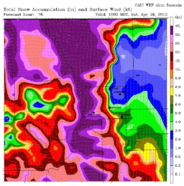
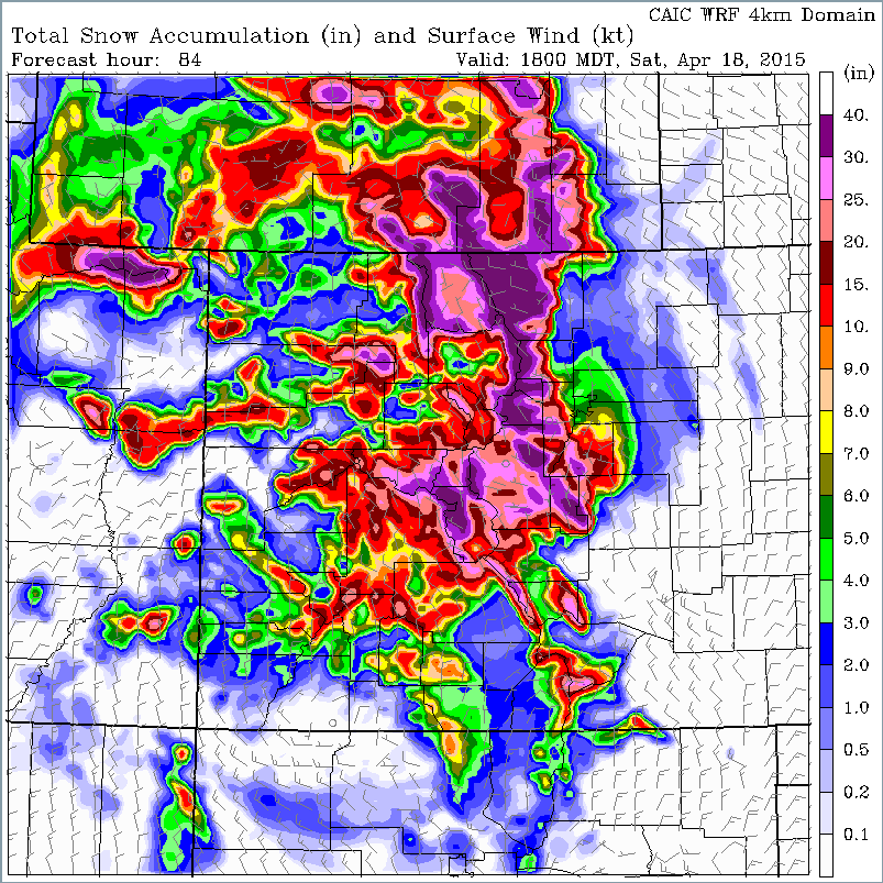
Another uncertainty is the time of year, April. A high spring sun-angle, combined with warm ground temperatures, will be a road block to accumulation. Given the warm ground, we would suspect most accumulations will be on grassy surfaces in the city of Boulder through the duration of the storm. The below figure shows the total precipitation (snowfall only) for Colorado from the WRF model through Saturday. The WRF tends to overestimate precipitation totals. However, as you can see, a large section of the state will see precipitation, with the mountains over a foot of snow, and between 1-2 feet in the foothills west of Boulder.
6. Forecast
As mentioned earlier, the prime time for this storm event will be Thursday night into Friday morning given the track and timing of the storm.
For Thursday, the cold front will have pushed through already, and easterly flow will become northeasterly during the afternoon hours. Clouds will increase during the day and temperatures will begin in the 40’s with dropping temperatures by mid to late afternoon into the 30’s. We would not be surprised if precipitation in the form of rain starts in the late morning or early afternoon. And there could be a few snow showers mixed in, but no accumulation. The heavier precipitation will be Thursday night, after 6pm. Expect a mix of rain and snow early on, transitioning over to mostly snow between 10 pm and midnight for Boulder and the surrounding plains. In the foothills, this transition will be soon. If the storm trends colder, this changeover to snow could occur sooner in all areas. The heaviest precipitation should taper off by late Friday morning. The GFS is hinting at another possible wave Friday evening as the system rotates eastward. However, given the upper level flow Friday switching to northwesterly, this secondary hit will be much less significant.
7. Snow Amounts:
Foothills of Boulder County: This should be primarily a snow event for the Foothills, as snow levels should be at or below 6500 feet through the duration of the storm. 10 to 20” of snow is certainly possible, given the strong dynamics, moisture, and lift with the system. Precipitation amounts from the models are consistently showing 1.5 inches of liquid equivalent, which given snow to liquid ratios of 10:1, yields the forecasted snowfall amounts.
Boulder County Plains: This will be the trickiest forecast. Given dew points in the low and middle 30’s and wet-bulb temperatures near to above freezing, most snow accumulations will have to be on grassy surfaces. However, as mentioned before, dynamic cooling and the likely warm bias of the model temperatures, we could see 4-6 ” in the city. If the temperatures trend warmer, 2-4” is more likely, but if trending colder, 6-10”would be possible. Heading eastward on the plains of Boulder County, less favorable upslope will produce snowfall an inch or two less, in all scenarios.
Denver Metro: Since Denver is going to be slightly warmer than Boulder, amounts in the 1-5” range are possible. However, larger uncertainties exist here, depending on where the heavy banded precipitation sets up, and the impact of the warmer wet-bulb temperatures.
High Country: It looks like perfect ski weather for April. The San Juan mountains should get 6-10” of snow, which will be good for their snowpack. This snow will primarily occur in this region Thursday. Northwestern Colorado and near Steamboat, skiers will be treated to up to a foot of snow, likely occurring tonight into Friday. The Sawatch, Park, and Front Range mountains will get dumped on Thursday night and Friday as the flow becomes more easterly and northerly. Expect 12-24” of snow in this region, with up to 36” possible on favorable east facing slopes. It is likely avalanches will occur Friday and Saturday, so exercise caution. Drivers of I-70 should be careful if out Thursday night and Friday as several of the passes will get snow packed, including Vail Pass and Loveland Pass. The best time to get fresh powder for skiing will be Friday and Saturday. Though Saturday looks to be the better day given the improving travel conditions. Enjoy skiing if you go up this weekend!
—
Stay tuned! The subtle nuances of this storm are sure to evolve over the next 24 to 36 hours and we will be updating you. The models never handle cut-off low pressure systems very well. Stay up to date by subscribing to BoulderCAST for email updates and also by following us on Twitter and Facebook. All of this can be done near the top of the page in the right-hand sidebar!


You must be logged in to post a comment.