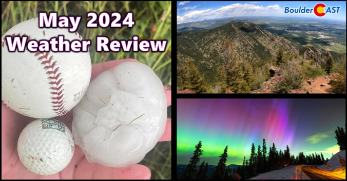
2024 began very soggy across the Front Range, but the month of May did a complete one-eighty concluding as Boulder’s driest in 50 years and 2nd driest since record-keeping began in the late 1800s. Other notable weather events during the month include the once-in-a-lifetime northern lights display visible across almost the entire United States and also what is likely to be yet another “billion-dollar hailstorm” which slammed parts of the Denver Metro area on May 30th. Here’s a quick and colorful graphical recap of our weather during May and how it relates to climatology.
Author: BoulderCAST Team (Page 9 of 45)
This post had major contributions from at least two members of our team. The more meteorologists the better, right?
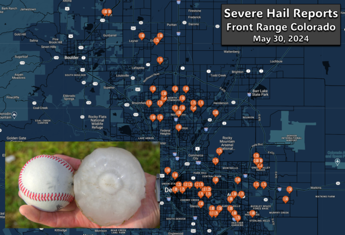
A pair of severe, supercell thunderstorms exploded across the northern Front Range late Thursday evening with very little advanced notice for residents. Hail larger than baseballs caused significant property damage on the northern and northeastern Metro area — roofing, siding, car windows and gardens stood no chance against the onslaught. The hail repair and insurance scammers are probably already knocking on doors this morning or making cold calls! We take a look at where the largest hail fell and why the forecast was so poor.
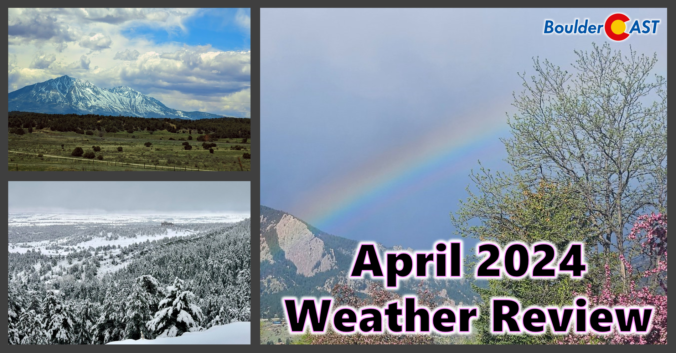
Despite having a two-week-long dry stretch thrown into the mix, the month of April concluded wetter than normal for most of the Front Range. However, much of this moisture came from a soaking rainstorm (with a little snow) near the end of the month. Nonetheless, 2024 has begun as one of the all-time wettest in Boulder. We also endured an intense downslope windstorm near the beginning of April, but who could forget that? Xcel Energy customers sure wouldn’t! Here’s a quick and colorful graphical recap of our weather during April and how it relates to climatology.
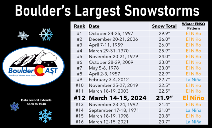
The month of March was fairly dry and chilly most of the time, but we can’t forget the historic El Niño snowstorm which slammed the entire Front Range around the middle of the month. Snow totals of 1 to 2 feet occurred in Boulder and Denver with up to 5 feet fell in the nearby Foothills. Here’s a quick and colorful graphical recap of our weather during March and how it relates to climatology.
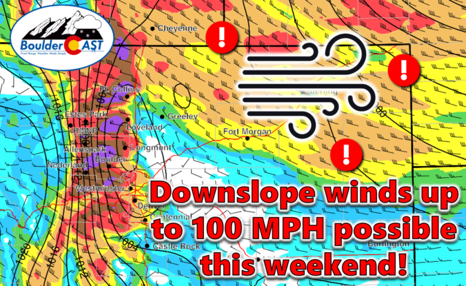
An exceptionally strong spring storm is approaching Colorado which will develop into a big ol’ blizzard in the coming days. However, unlike the last few storms which have been direct hits on the Front Range, this one will track further north leading to more wind than precipitation in our area. After a warm and gusty Friday with high fire danger, the incoming storm will bring colder temperatures and a brief chance of rain/snow showers on Saturday. The biggest impacts from this system, though, will come in the form of prolonged damaging downslope winds. We take a look at the large-scale atmospheric setup and discuss the potential snowfall amounts and which unlucky areas have a chance at wind gusts up to 100 MPH this weekend.
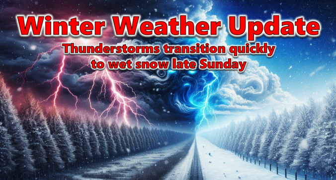
After a lengthy stretch of relatively quiet weather this past week as we officially transitioned from winter to spring, things are set to change on Sunday as a quick-moving storm system races into Colorado from the west with rain, hail, and thunder Sunday afternoon transitioning to heavy snow by Sunday evening. Several inches of accumulation will be possible with this storm, favoring the Palmer Divide and southern Foothills, but for the most part it’s moving too quickly to generate significant snow in our area. Winds will gust upwards of 45 MPH at times Sunday evening and night creating brief near-blizzard conditions in some locations. Read on as we discuss the latest forecast details, timing, and our projected snowfall amounts.
UPDATE (Sun 3/24/2024 8AM): Snowfall amounts were adjusted upwards an inch or two in some areas. Check our updated snowfall forecast map near the end of the post. Otherwise, the going forecast looks fine with afternoon thunderstorms quickly changing to snow after 6PM. Snow could be very heavy at times Sunday evening with 2″/hr snowfall rates. Gusty winds will create blowing snow and reduced visibility as well. Snow is still expected to end late Sunday night after midnight.
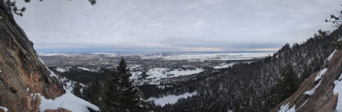
As promised, a well-advertised spring-like snowstorm delivered the goods to (almost) the entire Front Range this week with over four feet of snow falling in the Foothills and up to 2 feet across the lower elevations. We take a look back at this odd, moisture-infused winter storm, discussing how the difficult forecast evolved during the lead up and ultimately how much rain and snow pummeled the area.

Live View of Boulder

Current Conditions

Live Radar

Recent Premium Posts

BoulderCAST Daily – Sun 01/11/26 | A mild Sunday with readings reaching the 50s
🌤️ Mild & Melty Sunday: Light winds and patchy clouds, with lingering snowpack …
BoulderCAST Daily – Sat 01/10/26| Widespread sunshine and moderating temperatures this weekend as our recent snow melts off
🌤️ Calm Saturday: Winter storm systems have departed the state, leaving behind a …
BoulderCAST Daily – Fri 01/09/26| Snow ends quickly this morning with a quieter weekend in store
❄️ Overnight snow bands: A second push of upslope after midnight sparked narrow …
3-Day Forecast

Trending Content

© 2026 Front Range Weather, LLC