Author: Ben Castellani (Page 83 of 301)
Ben grew up in southwestern Pennsylvania and holds both a bachelor's and a master's degree in Meteorology, the latter being from CU Boulder. His hometown received nearly three feet of snow from the Storm of the Century back in March of 1993, sparking his initial interest in impactful weather. Ben currently works on remote sensing and data analysis software at NV5 Geospatial Software in Boulder.

We concluded the already very snowy and cold month of November with even more snow and cold on Tuesday. A brief period of moderate to heavy snow led to a slick morning commute in many areas, with some of the coldest air of the season filtering in as the snow cleared out. Let’s take a look at the snowfall totals across the area, review November’s weather so far, and discuss the largely pleasant weather that lies ahead.
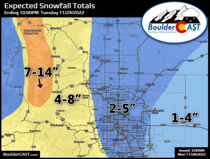
After a largely quiet and long Thanksgiving weekend, things get going quickly this week with widespread accumulating snow developing across the Front Range late Monday night into Tuesday alongside much colder conditions. Afterwards, the rest of the week will see moderating temperatures and generally dry/quiet weather, but we are tracking more snow in the Mountains on Friday. Read on for all the details.

Live View of Boulder

Current Conditions

Live Radar

Recent Premium Posts

BoulderCAST Daily – Tue 04/28/26 | Staying cool with a couple showers, the late-week storm is still the main event despite trending south
🌧️ Morning wave = main show, with light rain showers and Foothills wet …
BoulderCAST Daily – Sun 04/26/26 | Showers and some storms later today and this evening
🌧️ A wet afternoon and early evening, with showers and a few rumbles …
BoulderCAST Daily – Sat 04/25/26 | Cooler today and wet Sunday into early next week
🌧️ A wet latter part of the weekend, with showers and a few …
3-Day Forecast

Trending Content

© 2026 Front Range Weather, LLC