
After a hot and dry Monday, the rest of the week ahead will see cooler and stormy conditions unfold across the Front Range, the the focus centered on another damaging hail outbreak on the Fourth of July holiday. Much cooler weather arrives Wednesday with at least one cold-related historical record up for grabs. The Southwest monsoon remains delayed with little hope of it arriving anytime soon. Let’s take a look at yet another active week in Colorado weather!
Author: Ben Castellani (Page 70 of 303)
Ben grew up in southwestern Pennsylvania and holds both a bachelor's and a master's degree in Meteorology, the latter being from CU Boulder. His hometown received nearly three feet of snow from the Storm of the Century back in March of 1993, sparking his initial interest in impactful weather. Ben currently works on remote sensing and data analysis software at NV5 Geospatial Software in Boulder.
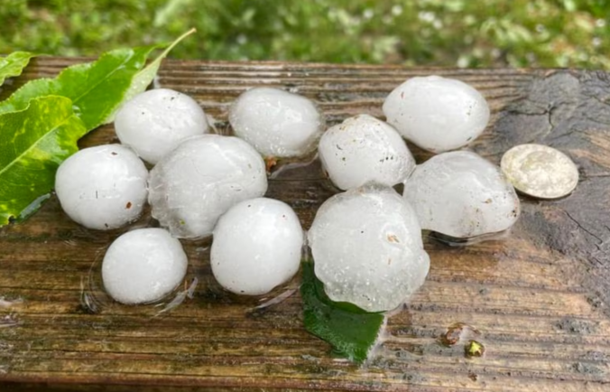
Yesterday was absolutely wild across essentially all of eastern Colorado as dozens of supercell thunderstorms slammed the region with widespread damaging hail and flooding rains, while up to a dozen tornadoes touched down on the far eastern Plains. Fortunately, Mother Nature’s encore performance of severe weather on Thursday isn’t expect to be quite as bad, but the risk remains relatively high again for damaging hail and locally flooding downpours in the Front Range. Let’s dive in! (yes, that was a pun)


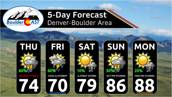
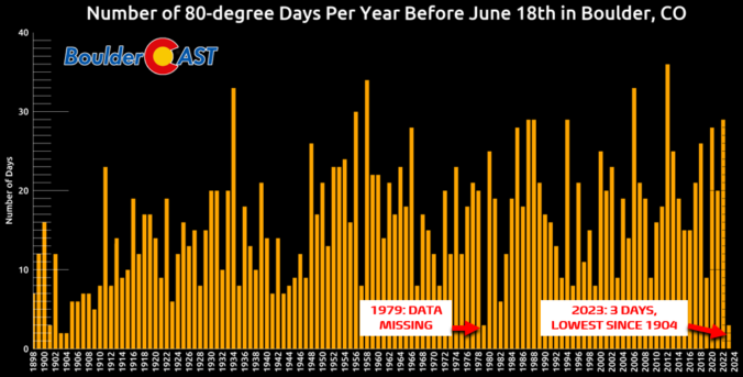
Whether you like it or not, Front Range Colorado has finally turned a corner on the cool and soggy weather lingering across the area the last few months — just in time for the first day of summer on Wednesday! While the week ahead will offer a few chances for rain, and even some severe storms at times, the overall trend heading into the end of June will be towards drier and hotter weather. Let’s take a look!
NOTICE: Due to the federal holiday, our usual Monday weekly outlook will be posted instead on Tuesday. Please check back then for the latest on Front Range weather!

Live View of Boulder

Current Conditions

Live Radar

Recent Premium Posts

BoulderCAST Daily – Sun 05/31/26 | Dry and warm today but rain chances increase this week
🌦️ Overall dry and warm Sunday, though cannot rule out a very widely …
BoulderCAST Daily – Sat 05/30/26 | A stray shower today as most activity resides well east of Denver
🌦️ Spotty showers today, mainly well east of the Denver Metro area, where …
BoulderCAST Daily – Fri 05/29/26 | A Marginal Risk of Severe Isolated Storms
🌦️ Spotty showers this afternoon, mainly noon and 4 PM, with highs in …
3-Day Forecast

Trending Content

© 2026 Front Range Weather, LLC